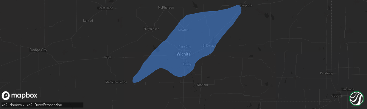
Hail Map in Wichita, KS on July 2, 2024
The weather event in Wichita, KS on July 2, 2024 includes Hail, Wind, and Tornado maps. 12 states and 523 cities were impacted and suffered possible damage. The total estimated number of properties impacted is 0.
Hail
Wind
Tornado
0
Estimated number of impacted properties by a 1.00" hail or larger0
Estimated number of impacted properties by a 1.75" hail or larger0
Estimated number of impacted properties by a 2.50" hail or largerStorm reports in Wichita, KS
Wichita, KS
| Date | Description |
|---|---|
| 07/02/20245:58 PM CDT | Awos station kaao 2 ese bel aire. |
| 07/02/20245:55 PM CDT | Reported several large tree limbs down in riverside park. |
| 07/02/20245:50 PM CDT | Trees down. Report came in via social media. |
| 07/02/20245:50 PM CDT | Tree blocking road near 21st and tyler. |
| 07/02/20245:49 PM CDT | Reported by kake broadcast media. |
| 07/02/20245:46 PM CDT | Large tree down on home near 13th and west. Report came in via social media. |
| 07/02/20245:45 PM CDT | A local report indicates 60 MPH wind near 1 SE Wichita Eisenhower |
| 07/02/20245:32 PM CDT | A local report indicates 59 MPH wind near 1 SE Wichita Eisenhower |
| 07/02/20245:32 PM CDT | A local report indicates 65 MPH wind near 3 NW Wichita Eisenhower |
All States Impacted by Hail Map on July 2, 2024
All Cities Impacted by Hail Map on July 2, 2024
- New Salem, ND
- Hazen, ND
- Beulah, ND
- Center, ND
- Stanton, ND
- Washburn, ND
- Exeter, NE
- Milligan, NE
- Friend, NE
- Geneva, NE
- Dorchester, NE
- Milford, NE
- Palmyra, NE
- Walton, NE
- Elmwood, NE
- Eagle, NE
- Bennet, NE
- Lincoln, NE
- Denton, NE
- Roca, NE
- Crete, NE
- Martell, NE
- Pleasant Dale, NE
- Malcolm, NE
- Davey, NE
- Raymond, NE
- Hogeland, MT
- Monticello, NM
- Hillsboro, NM
- Los Alamos, NM
- Benson, AZ
- Winterset, IA
- Griswold, IA
- Prole, IA
- Stanberry, MO
- Albany, MO
- Milo, IA
- Ackworth, IA
- Indianola, IA
- Knoxville, IA
- Pleasantville, IA
- Osceola, IA
- Swan, IA
- Humeston, IA
- Corydon, IA
- Saint Charles, IA
- Chariton, IA
- New Virginia, IA
- Murray, IA
- Otley, IA
- Pella, IA
- Darlington, MO
- King City, MO
- Raton, NM
- Truro, IA
- Laguna, NM
- San Simon, AZ
- Bowie, AZ
- Princeton, MO
- Mercer, MO
- Russell, IA
- Harvey, IA
- Cainsville, MO
- Sully, IA
- McFall, MO
- Martinsville, MO
- Bethany, MO
- New Hampton, MO
- Attica, KS
- Spivey, KS
- Harper, KS
- Kingman, KS
- Rea, MO
- Union Star, MO
- Ridgeway, MO
- Magdalena, NM
- Promise City, IA
- Allerton, IA
- Lineville, IA
- New Sharon, IA
- Savannah, MO
- Melrose, IA
- Montezuma, IA
- Barnes City, IA
- Deep River, IA
- Gibson, IA
- Murdock, KS
- Norwich, KS
- Milton, KS
- Cheney, KS
- Keswick, IA
- What Cheer, IA
- Webster, IA
- Folsom, NM
- Seymour, IA
- Plano, IA
- Albia, IA
- North English, IA
- Viola, KS
- Garden Plain, KS
- Goddard, KS
- Andale, KS
- Mount Hope, KS
- Gilman City, MO
- Mystic, IA
- Centerville, IA
- Oskaloosa, IA
- Rose Hill, IA
- Cedar, IA
- Fremont, IA
- Hedrick, IA
- Delta, IA
- Ottumwa, IA
- Bloomfield, IA
- Drakesville, IA
- Moulton, IA
- Hayesville, IA
- Agency, IA
- Martinsburg, IA
- Eldon, IA
- Floris, IA
- Sigourney, IA
- Guernsey, IA
- Marengo, IA
- Ladora, IA
- Williamsburg, IA
- Victor, IA
- South English, IA
- Millersburg, IA
- Keota, IA
- Wellman, IA
- Parnell, IA
- Harper, IA
- Packwood, IA
- Ollie, IA
- Batavia, IA
- Atchison, KS
- Rushville, MO
- Haven, KS
- Moravia, IA
- Powersville, MO
- Lucerne, MO
- Clearwater, KS
- Conway Springs, KS
- Wellington, KS
- Wichita, KS
- Colwich, KS
- Belle Plaine, KS
- Peck, KS
- Haysville, KS
- Pretty Prairie, KS
- Valley Center, KS
- Maize, KS
- Sedgwick, KS
- Mulvane, KS
- Kechi, KS
- Derby, KS
- Carmen, OK
- Cherokee, OK
- Helena, OK
- Jet, OK
- Childress, TX
- Faucett, MO
- De Kalb, MO
- Saint Joseph, MO
- Tucson, AZ
- Unionville, MO
- Spickard, MO
- Manchester, OK
- Anthony, KS
- Galata, MT
- Kalona, IA
- Clarksdale, MO
- Oxford, IA
- Council Grove, KS
- Jarales, NM
- Richland, IA
- Newtown, MO
- Pollock, MO
- Wakita, OK
- Nash, OK
- Halstead, KS
- Newton, KS
- Bentley, KS
- Burrton, KS
- North Newton, KS
- Walton, KS
- Mcconnell Afb, KS
- Benton, KS
- Andover, KS
- Greenwich, KS
- Augusta, KS
- Rose Hill, KS
- Douglass, KS
- Whitewater, KS
- Hesston, KS
- Moundridge, KS
- Elbing, KS
- Potwin, KS
- Peabody, KS
- Towanda, KS
- El Dorado, KS
- Leon, KS
- Burns, KS
- Florence, KS
- Marion, KS
- Hillsboro, KS
- Selma, IA
- Brighton, IA
- Libertyville, IA
- Douds, IA
- Washington, IA
- West Chester, IA
- Fairfield, IA
- Riverside, IA
- Iowa City, IA
- Tiffin, IA
- North Liberty, IA
- Coralville, IA
- Solon, IA
- West Branch, IA
- Ainsworth, IA
- Hills, IA
- Tipton, IA
- West Liberty, IA
- Lone Tree, IA
- Harris, MO
- Galt, MO
- Pattonsburg, MO
- Americus, KS
- Maysville, MO
- Amity, MO
- Arenas Valley, NM
- Agency, MO
- Gower, MO
- Nichols, IA
- Columbus Junction, IA
- Conesville, IA
- Mechanicsville, IA
- Atalissa, IA
- Wilton, IA
- Moscow, IA
- Crawfordsville, IA
- Wayland, IA
- Mount Pleasant, IA
- Grandview, IA
- Muscatine, IA
- Wapello, IA
- Columbus City, IA
- Letts, IA
- Illinois City, IL
- Fruitland, IA
- Durant, IA
- Grenville, NM
- Milan, MO
- Admire, KS
- Allen, KS
- Weatherby, MO
- Cedar Point, KS
- Cassoday, KS
- Dacoma, OK
- Strong City, KS
- Elmdale, KS
- Lincolnville, KS
- Cottonwood Falls, KS
- Matfield Green, KS
- Taylor Ridge, IL
- Davenport, IA
- Stockton, IA
- Bennett, IA
- Buffalo, IA
- Walcott, IA
- Blue Grass, IA
- Clarence, IA
- Montpelier, IA
- New Liberty, IA
- Lowden, IA
- Stanwood, IA
- Lisbon, IA
- Wheatland, IA
- Oxford Junction, IA
- Dixon, IA
- Emporia, KS
- Birmingham, IA
- Humphreys, MO
- Milton, IA
- Keosauqua, IA
- Dearborn, MO
- Platte City, MO
- Camden Point, MO
- Green City, MO
- Rock Island, IL
- Milan, IL
- Reynolds, IL
- Andalusia, IL
- New Boston, IL
- Joy, IL
- Calamus, IA
- Osco, IL
- Moline, IL
- Donahue, IA
- Sherrard, IL
- Eldridge, IA
- Orion, IL
- East Moline, IL
- Coal Valley, IL
- Bettendorf, IA
- Silvis, IL
- Delmar, IA
- Lost Nation, IA
- Carbon Cliff, IL
- Hampton, IL
- Pleasant Valley, IA
- Colona, IL
- Grand Mound, IA
- Long Grove, IA
- Maquoketa, IA
- De Witt, IA
- Geneseo, IL
- Port Byron, IL
- Rapids City, IL
- Princeton, IA
- Le Claire, IA
- Hillsdale, IL
- Stockport, IA
- Trenton, MO
- Olpe, KS
- Osborn, MO
- Easton, MO
- Stewartsville, MO
- Plattsburg, MO
- Turney, MO
- Cameron, MO
- Kingston, MO
- Winston, MO
- Kidder, MO
- Hamilton, MO
- Jameson, MO
- Altamont, MO
- Gallatin, MO
- Ludlow, MO
- Breckenridge, MO
- Utica, MO
- Lock Springs, MO
- Chillicothe, MO
- Mooresville, MO
- Jamesport, MO
- Camanche, IA
- McCausland, IA
- Goose Lake, IA
- Charlotte, IA
- Welton, IA
- Cordova, IL
- Clinton, IA
- Bryant, IA
- Low Moor, IA
- Fulton, IL
- Albany, IL
- Erie, IL
- Prophetstown, IL
- Hingham, MT
- New London, IA
- Hillsboro, IA
- Salem, IA
- Linwood, KS
- Tonganoxie, KS
- Clayton, NM
- Fenton, IL
- Lyndon, IL
- Morrison, IL
- Chula, MO
- Laredo, MO
- Wheeling, MO
- Linneus, MO
- Meadville, MO
- Laclede, MO
- Brookfield, MO
- Browning, MO
- Purdin, MO
- Edgerton, MO
- Trimble, MO
- Lathrop, MO
- Polo, MO
- Cowgill, MO
- Braymer, MO
- Sterling, IL
- Thomson, IL
- Chadwick, IL
- Sabula, IA
- Winigan, MO
- Novinger, MO
- Ethel, MO
- Green Castle, MO
- Elmer, MO
- La Plata, MO
- Kirksville, MO
- New Boston, MO
- Holt, MO
- Aline, OK
- Lawson, MO
- Brashear, MO
- Gibbs, MO
- Greentop, MO
- Hurdland, MO
- Baring, MO
- Edina, MO
- Novelty, MO
- Mutual, OK
- Nortonville, KS
- Cummings, KS
- Basehor, KS
- Bonner Springs, KS
- Leavenworth, KS
- Kansas City, KS
- Shawnee, KS
- Kansas City, MO
- Waldron, MO
- Riverside, MO
- Liberty, MO
- Excelsior Springs, MO
- Rayville, MO
- Richmond, MO
- Knox City, MO
- La Belle, MO
- Lewistown, MO
- Monticello, MO
- Mooreland, OK
- Valley Falls, KS
- Overland Park, KS
- Arnett, OK
- Rutledge, MO
- Memphis, MO
- Olathe, KS
- Williamstown, MO
- Vici, OK
- Prairie Village, KS
- Leawood, KS
- Grandview, MO
- Bucklin, MO
- Dawn, MO
- Lees Summit, MO
- Independence, MO
- Blue Springs, MO
- Greenwood, MO
- Pleasant Hill, MO
- Belton, MO
- Raymore, MO
- Lone Jack, MO
- Kingsville, MO
- Grain Valley, MO
- Buckner, MO
- Napoleon, MO
- Sibley, MO
- Bates City, MO
- Wellington, MO
- Oak Grove, MO
- Odessa, MO
- New Cambria, MO
- Weston, MO
- Holden, MO
- Seiling, OK
- Taloga, OK
- Chester, OK
- Fairview, OK
- Lexington, MO
- Mayview, MO
- Centerview, MO
- Amarillo, TX
- Sharon, OK
- Troy, KS
- Sedan, NM
- Fritch, TX
- Macomb, IL
- Industry, IL
- Brunswick, MO
- Denton, KS
- Bendena, KS
- Colchester, IL
- Littleton, IL
- Callao, MO
- Keytesville, MO
- Marceline, MO
- Salisbury, MO
- Vermont, IL
- Adair, IL
- Table Grove, IL
- Astoria, IL
- Rushville, IL
- Walsenburg, CO
- Cumberland, IA
- Ipava, IL
- Clifton Hill, MO
- Lewistown, IL
- Smithfield, IL
- Huntsville, MO
- Dalton, MO
- Cosby, MO
- Helena, MO
- Excello, MO
- Jacksonville, MO
- Cairo, MO
- Macon, MO
- Moberly, MO
- Dalhart, TX
- Higbee, MO
- Clark, MO
- Madison, MO
- Sturgeon, MO
- Centralia, MO
- Stratford, TX
- Texhoma, OK
- Masterson, TX
- Rocky Ford, CO
- Ulysses, KS
- La Junta, CO
- Karval, CO
- Hugo, CO
- Manzanola, CO
- Fowler, CO
- Olney Springs, CO
- Ordway, CO
- Sugar City, CO
- Cheraw, CO


