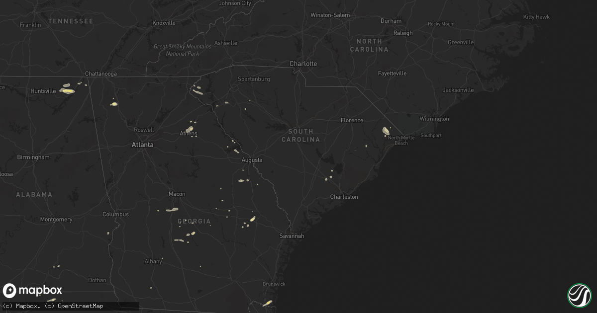
Hail Map in South Carolina on July 2, 2015
Get this storm
July 2 map
$229
one time, instant access
Download today. No call, no setup
Keep the $229
Bought the map and want the full workflow? Apply the entire $229 to a subscription within 7 days. None of it is wasted.
Every map, not just this one
This buys you this map. Subscription and you get every map we run, in the markets you choose from a few cities to whole states to nationwide. Plus real-time alerts the moment a storm fires.
Contact data
Name, contact info, occupancy, even credit band for addresses in the footprint. You go from where it hit to who to call.
Become the source they trust
Unlimited branding weather history reports on demand. You already have the documented answer ready for the property owner, and you are the one who showed up with it.
Property data and RoofTrace estimates
Pull up any address you have got, its value and the exact code rules for that jurisdiction, straight from One Click Code. Then RoofTrace estimates the squares, pitch, and roof value, priced the way you price.
Storm reports in South Carolina
South Carolina
| Date | Description |
|---|---|
| 07/02/20156:57 PM CDT | Tree down on orangeburg rd at dorchester rd. |
| 07/02/20156:54 PM CDT | A tree was blown down along dolphin point drive on cat island. Time of event was estimated from radar data. |
| 07/02/20156:54 PM CDT | County warning point reports several trees down on hilton head island. |
| 07/02/20156:54 PM CDT | County warning point reports several trees down on hilton head island. |
| 07/02/20156:46 PM CDT | County warning point reports several trees down on ladys island. |
| 07/02/20156:43 PM CDT | Multiple trees were blown down in the port royal area. Time of event was estimated from radar data. |
| 07/02/20156:40 PM CDT | County warning point reports numerous trees down in and around beaufort. |
| 07/02/20156:35 PM CDT | Several trees were blown down in the burton area. One tree fell on a house. Time of event was estimated from radar data. |
| 07/02/20156:33 PM CDT | A tree was blown down along pinckney colony road. Time of event was estimated from radar data. |
| 07/02/20156:31 PM CDT | Report of tree in roadway on park ave near turbeville hwy. |
| 07/02/20156:25 PM CDT | South carolina highway patrol reported a tree down on jacksonboro road near cottageville. Time of event was estimated from radar data. |
| 07/02/20156:17 PM CDT | Sc state highway patrol reports a tree down in the 9700 block of jacksonboro rd |
| 07/02/20156:06 PM CDT | Sc state hwy patrol reports a tree down on interstate 95 nb at mile marker 46 |
| 07/02/20156:00 PM CDT | Sc state hwy patrol reports tree down in 4800 block of peirce rd |
| 07/02/20155:58 PM CDT | South carolina highway patrol reported a tree down on forks road near the sineath road intersection. Time of event was estimated from radar data. |
| 07/02/20155:55 PM CDT | Sc state highway patrol reports a tree down in the 6700 block of rehoboth rd |
| 07/02/20155:50 PM CDT | Tree down at the intersection of seven acres rd and cypress grove ln |
| 07/02/20155:37 PM CDT | Sc state hwy patrol reports a tree down on us rt 601 just north of crocketville |
| 07/02/20155:34 PM CDT | Sc state hwy patrol reports tree down on hope well rd near the intersection with grass hill rd |
| 07/02/20155:28 PM CDT | A tree was blown down onto power lines and a power pole was snapped at the intersection of reed street and south parler avenue. |
| 07/02/20155:01 PM CDT | Sc highway patrol reported trees down near re davis elementary school. Time estimated from radar. |
| 07/02/20154:58 PM CDT | Report of powerlines down in roadway near at intersection of e old marion hwy and weatherford ln. Time estimated by radar. |
| 07/02/20154:53 PM CDT | Sc highway patrol reported trees in the roadway on plowden mill road and radical road in sumter. Time estimated from radar. |
| 07/02/20154:46 PM CDT | Report of tree in roadway near intersection of gilchrist rd and wire rd. Time estimated by radar. |
| 07/02/20154:38 PM CDT | A tree was reported down near the intersection of pocket road and charleston road. The time was estimated based on radar data. |
| 07/02/20154:36 PM CDT | Report of tree down on e mciver rd near wellman rd. Time estimated by radar. |
| 07/02/20154:24 PM CDT | Reported several trees down along gardenia road. |
| 07/02/20154:24 PM CDT | Trained spotter reported via social media trees down in the town of north and a measured wind gust of 52 mph. |
| 07/02/20154:21 PM CDT | Report of tree in roadway at intersection of pocket rd and oxford rd. Time estimated by radar. |
| 07/02/20154:21 PM CDT | A tree was reported down in the 600 block of gilchrist road. The time was estimated based on radar data. |
| 07/02/20154:17 PM CDT | Report of tree down on n main st near citi trends. Time estimated by radar. |
| 07/02/20153:57 PM CDT | Sc highway patrol reported trees down in north augusta near the 5th street bridge. |
| 07/02/20153:55 PM CDT | Wagt reported a tree on a house along radiance drive in n. Augusta. |
| 07/02/20153:52 PM CDT | Richland county mesonet reported a wind gust of 70 mph atop williams brice stadium. |
| 07/02/20153:47 PM CDT | Public reported through twitter that a tree fell on a house in the olympia neighborhood of columbia. |
| 07/02/20153:45 PM CDT | Sc highway patrol reported trees down near the intersection of gardners terrace road and highway 321. |
| 07/02/20153:29 PM CDT | Sheriff dispatch reported trees down along white oak church road. |
| 07/02/20153:28 PM CDT | Highway department reported trees down along whaley pond road near gooseberry court. |
| 07/02/20153:25 PM CDT | Sheriff dispatch reported trees down along old river road. |
| 07/02/20153:25 PM CDT | Sc highway patrol reported trees down along old graniteville road and along i 20 near vaucluse. Time estimated from radar. |
| 07/02/20153:21 PM CDT | Sheriff dispatch reported trees down along 9th street in winnsboro mills. |
| 07/02/20153:20 PM CDT | Trees down near the town of kershaw. |
| 07/02/20153:20 PM CDT | Public reported large branches down near dutch fork high school via social media. |
| 07/02/20153:05 PM CDT | Sheriff dispatch reported trees down along garrett road. |
| 07/02/20153:04 PM CDT | Trees down along highway 121/72 |
| 07/02/20153:00 PM CDT | Sc highway patrol reported trees down near the intersection of mt pleasant rd and ringer road. |
| 07/02/20152:48 PM CDT | Highway patrol reported trees down near the intersection of highway 176 and route 121. |
| 07/02/20152:44 PM CDT | Highway patrol reported trees down along jalapa road between i-26 and highway 76. |
| 07/02/20152:40 PM CDT | Tree down on hwy 56 s and hwy 560 |
| 07/02/20152:40 PM CDT | Highway patrol reported trees down along i-26 near mile marker 63. |
| 07/02/20152:40 PM CDT | Tree down on hwy 56 s and milton rd |
| 07/02/20152:40 PM CDT | Trees down on hwy 26 just south of clinton |
| 07/02/20152:35 PM CDT | 30 ft tall oak tree down on presbyterian college campus |
| 07/02/20152:15 PM CDT | Tree down near eastside baptist church. Time estimated from radar |
| 07/02/20152:15 PM CDT | Power lines down off pond view dr. Time estimated from radar |
| 07/02/20151:45 PM CDT | Tree and powerlines down off vinewood st in piedmont |
| 07/02/20151:45 PM CDT | Tree down on fairview rd at hwy 418 in simpsonville |
| 07/02/20151:45 PM CDT | Tree down off hwy 25 |
| 07/02/20151:40 PM CDT | Trees down at e calhoun st and old colony rd |
| 07/02/20151:40 PM CDT | Tree down in piedmont near bonanza cir |
| 07/02/20151:00 PM CDT | Trees down on poplar springs rd near seneca post office |
| 07/02/201512:35 PM CDT | Trees down on battlecreek rd and damascus church rd |
| 07/01/20157:28 PM CDT | Large bradford pear tree broken in half by wind on rosemead rd |
| 07/01/20157:28 PM CDT | Tree down on lucas st by shem creek |
All States Impacted by Hail Map on July 2, 2015
Cities Impacted by Hail Map on July 2, 2015
- Mancos, CO
- Turpin, OK
- Geneva, NE
- Shickley, NE
- Sutton, NE
- Manhattan, KS
- Fowler, KS
- Meade, KS
- Frankford, DE
- Selbyville, DE
- Cimarron, NM
- Perry, OK
- Jemez Springs, NM
- Ravenden, AR
- Mountain Rest, SC
- Walhalla, SC
- Westminster, SC
- Grants, NM
- Nakina, NC
- Cochran, GA
- Hawkinsville, GA
- Sapello, NM
- Loris, SC
- Garden City, KS
- Coweta, OK
- Porter, OK
- Broken Arrow, OK
- Wagoner, OK
- Tulsa, OK
- Hollywood, AL
- Scottsboro, AL
- Willcox, AZ
- La Crosse, KS
- Bison, KS
- Rockledge, FL
- Merritt Island, FL
- Melbourne, FL
- Cocoa, FL
- Chester, OK
- Silver City, NM
- Glendale, UT
- Russell, KS
- Waldo, KS
- Paradise, KS
- Davenport, NE
- Cleveland, NM
- Bellemont, AZ
- Nicholson, GA
- Colbert, GA
- Athens, GA
- Hull, GA
- Stevenson, AL
- York, NE
- Bradshaw, NE
- Polk, NE
- Henderson, NE
- Billings, OK
- Siloam Springs, AR
- Lithia, FL
- Roswell, NM
- Venus, FL
- Perryton, TX
- Howard, CO
- Greenway, AR
- Piggott, AR
- Rector, AR
- Burke, SD
- Reading, KS
- Luther, OK
- Edmond, OK
- Laurel Hill, FL
- Laramie, WY
- Sardis, GA
- Aynor, SC
- Conway, SC
- Galivants Ferry, SC
- Tijeras, NM
- Guthrie, OK
- Englewood, KS
- Plains, KS
- Hulbert, OK
- Dozier, AL
- Brantley, AL
- Eastman, GA
- Metter, GA
- Register, GA
- Owasso, OK
- Douglas, AZ
- Forgan, OK
- Maramec, OK
- Cleveland, OK
- Harriet, AR
- Marshall, AR
- Keysville, GA
- Waynesboro, GA
- Louisville, GA
- Cuba, KS
- Belleville, KS
- Agenda, KS
- Gate, OK
- Supai, AZ
- Beaver, OK
- Mcville, ND
- Pekin, ND
- Calhoun, GA
- Dora, MO
- Brixey, MO
- Flippin, AR
- Mountain Home, AR
- Henryetta, OK
- Okmulgee, OK
- Saint Marys, GA
- Kings Bay, GA
- Kingsland, GA
- Yulee, FL
- Aurora, KS
- East Dublin, GA
- Pittsview, AL
- Panhandle, TX
- Jay, OK
- Booker, TX
- Canadian, TX
- Virginia Beach, VA
- Laurens, SC
- Watts, OK
- Colcord, OK
- Dolores, CO
- Fort Myers, FL
- Lehigh Acres, FL
- Portal, GA
- Clinton, KY
- Claremore, OK
- Buena Vista, NM
- Pitts, GA
- Cordele, GA
- Miami, TX
- Orderville, UT
- Elida, NM
- Portales, NM
- Pep, NM
- Paragould, AR
- Natoma, KS
- Rawlins, WY
- Abilene, KS
- Estancia, NM
- Ripley, OK
- Perkins, OK
- Stillwater, OK
- Shattuck, OK
- Fort Gibson, OK
- Claude, TX
- Reynolds, GA
- North Fort Myers, FL
- Punta Gorda, FL
- Sugar Valley, GA
- Pie Town, NM
- Cassville, MO
- Exeter, MO
- Seligman, MO
- Washburn, MO
- Clay Center, KS
- Laverne, OK
- Forest River, ND
- Follett, TX
- Miltonvale, KS
- Minneapolis, KS
- Fairview, OK
- Weleetka, OK
- Chesapeake, VA
- Abbeville, GA
- Hebron, NE
- Deshler, NE
- Hope, KS
- Muskogee, OK
- Huntsville, AR
- Berryville, AR
- Walnut Ridge, AR
- Bono, AR
- Adrian, GA
- Swainsboro, GA
- Mutual, OK
- Eureka Springs, AR
- Medina, TN
- Humboldt, TN
- Pelham, GA
- New Concord, KY
- Cotopaxi, CO
- Durango, CO
- Purdy, MO
- Butterfield, MO
- Buford, WY
- Tie Siding, WY
- Valrico, FL
- Bradleyville, MO
- Cross, SC
- Wellington, TX
- Shamrock, TX
- Danielsville, GA
- Everton, AR
- Western Grove, AR
- Arcadia, FL
- Belton, SC
- Torreon, NM
- Labelle, FL
- Moore Haven, FL
- Great Bend, KS
- Scandia, KS
- Tompkinsville, KY
- Mount Hermon, KY
- Alicia, AR
- Crestview, FL
- Hephzibah, GA
- Blythe, GA
- Lincolnton, GA
- Lake City, FL
- Lake Placid, FL
- Cuba, NM
- Baker, FL
- Pierceville, KS
- Kathleen, GA
- Bonaire, GA
- Fort Valley, GA
- Perry, GA
- Warner Robins, GA
- Quail, TX
- Mooreland, OK
- Brookland, AR
- Lake City, AR
- Littlefield, AZ
- Oklahoma City, OK
- Arcadia, OK
- Fackler, AL
- Westcliffe, CO
- Trenton, AL
- Woodville, AL
- Monette, AR
- Leachville, AR
- Bluewater, NM
- Jennings, OK
- Towaoc, CO
- Waterloo, SC
- Smithville, AR
- Lynn, AR
- Hampton, NE
- Hordville, NE
- Solomon, KS
- Rochelle, GA
- Hugoton, KS
- Tuckerman, AR
- Newport, AR
- Lakemont, GA
- Munden, KS
- Sylvester, GA
- Strawberry, AR
- Dublin, GA
- Cashion, OK
- Balko, OK
- Kingstree, SC
- Commerce, GA
- Estero, FL
- Brockwell, AR
- Pineville, AR
- Calico Rock, AR
- Salida, CO
- Bristow, OK
- Clarendon, TX
- Loxahatchee, FL
- Jones, OK
- Higdon, AL
- Flat Rock, AL
- Ocate, NM
- Yellville, AR
- Sandia Park, NM
- Ridgeville, SC
- Jonesboro, AR
- Alma, KS
- Hemingway, SC
- Berlin, MD
- Ocean City, MD
- Reeds Spring, MO
- Admire, KS
- Clifton, AZ
- Morenci, AZ
- Pawnee Rock, KS
- Mchenry, ND
- Soperton, GA
- Tarrytown, GA
- Naples, FL
- Datil, NM
- Bayfield, CO
- Willacoochee, GA
- Wray, GA
- Long Creek, SC
- Fargo, OK
- Lenora, KS
- Sperry, OK
- Rush Center, KS
- Wrightsville, GA
- Bonita Springs, FL
- Nekoma, KS
- Arnoldsville, GA
- Crawford, GA
- Blanding, UT
- Hays, KS
- Davisboro, GA
- Hoisington, KS
- Smithfield, NC
- Selma, NC
- Defuniak Springs, FL
- Longford, KS
- Hardy, AR
- Williford, AR
- Appling, GA
- Anderson, SC
- Claxton, GA
- Collins, GA
- Cobbtown, GA
- Hawthorne, FL
- Locust Grove, OK
- Peggs, OK
- Jewell, KS
- Black Rock, AR
- Larned, KS
- Center, CO
- Saguache, CO


