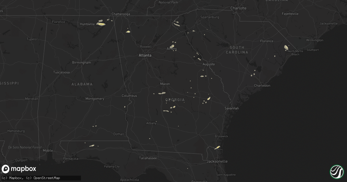
Hail Map in Georgia on July 2, 2015
Get this storm
July 2 map
$229
one time, instant access
Download today. No call, no setup
Keep the $229
Bought the map and want the full workflow? Apply the entire $229 to a subscription within 7 days. None of it is wasted.
Every map, not just this one
This buys you this map. Subscription and you get every map we run, in the markets you choose from a few cities to whole states to nationwide. Plus real-time alerts the moment a storm fires.
Contact data
Name, contact info, occupancy, even credit band for addresses in the footprint. You go from where it hit to who to call.
Become the source they trust
Unlimited branding weather history reports on demand. You already have the documented answer ready for the property owner, and you are the one who showed up with it.
Property data and RoofTrace estimates
Pull up any address you have got, its value and the exact code rules for that jurisdiction, straight from One Click Code. Then RoofTrace estimates the squares, pitch, and roof value, priced the way you price.
Storm reports in Georgia
Georgia
| Date | Description |
|---|---|
| 07/02/20156:45 PM CDT | A local report indicates 58 MPH wind near 1 SSW TYBEE ISLAND |
| 07/02/20156:00 PM CDT | Liberty county emergency manager reports many trees blown down in and around riceboro extending to the long county border. Trees brought down many power lines resulting |
| 07/02/20155:47 PM CDT | Tree down near the intersection of hwy 119 and hwy 80 north of ellabell. |
| 07/02/20155:45 PM CDT | Numerous large tree limbs...as large as 6 to 8 inches...down around the town of ludowici |
| 07/02/20155:25 PM CDT | Numerous large pine trees and limbs down near the east georgia regional medical center |
| 07/02/20155:13 PM CDT | Tree down across cyril p burkhalter road |
| 07/02/20155:00 PM CDT | Numerous trees down along statesboro highway near sylvania |
| 07/02/20154:57 PM CDT | Tree down on victory dr |
| 07/02/20154:57 PM CDT | Tree down on buttermilk rd just outside sylvania |
| 07/02/20154:56 PM CDT | Powerlines down caused a small fire along hwy 32 near the pierce county border. |
| 07/02/20154:56 PM CDT | Reports of trees and power lines down across southeast appling county near the intersection of georgia highway 15 as far as georgia 203. |
| 07/02/20154:55 PM CDT | Two trees were blown down along highway 129 near the hillview road intersection. Time of event was estimated from radar data. |
| 07/02/20154:52 PM CDT | Thunderstorm winds blew down power lines. |
| 07/02/20154:50 PM CDT | Powerlines blown down along red oak road. |
| 07/02/20154:46 PM CDT | Numerous trees and powerlines down in the city of alma. |
| 07/02/20154:44 PM CDT | Tree down on kemp st |
| 07/02/20154:40 PM CDT | Public reported tree down via social media. Time estimated by radar. |
| 07/02/20154:37 PM CDT | Spotter saw strong straight line winds estimated at 60 mph. |
| 07/02/20154:37 PM CDT | Burke county dispatch reported downed powerlines in the town of sardis. |
| 07/02/20154:32 PM CDT | Numerous large tree limbs...10 inches or more in diameter...blow onto powerlines on harvey street |
| 07/02/20154:24 PM CDT | Trees and powerlines reported down throughout the county including southeast sections along highway 16. |
| 07/02/20154:18 PM CDT | Tree down on spring street. |
| 07/02/20154:18 PM CDT | A tree was blown down along higway 84. |
| 07/02/20154:14 PM CDT | A tree was blown down along west plant avenue in homerville. |
| 07/02/20153:59 PM CDT | Tree down on hwy 122 near the clinch/lanier border. |
| 07/02/20153:55 PM CDT | Trees down along highway 441 north of pearson. Time of event based on radar imagery. |
| 07/02/20153:49 PM CDT | Tree down at lax hwy and lilac rd. |
| 07/02/20153:49 PM CDT | Multiple trees and powerlines down in the northern part of the county. |
| 07/02/20153:49 PM CDT | Numerous trees down across the county. |
| 07/02/20153:44 PM CDT | Trees down on east railroad street in wadley. Time estimated from radar. |
| 07/02/20153:37 PM CDT | Couple trees down across northern lowndes county. |
| 07/02/20153:36 PM CDT | 911 center reports numerous trees and powerlines down across northern houston county in the warner robins area. |
| 07/02/20153:36 PM CDT | Multiple trees and powerlines down across the county. |
| 07/02/20153:36 PM CDT | Trees down along clarks mill road in louisville. Time estimated from radar. |
| 07/02/20153:33 PM CDT | Reported several trees down along walton way. Structure damaged along walton way near the 3400 block. |
| 07/02/20153:22 PM CDT | Numerous trees down countywide. |
| 07/02/20153:18 PM CDT | Wagt reported blanchard road near paxton way impassable due to trees and powerlines down. |
| 07/02/20153:15 PM CDT | Columbia county dispatch reported trees down along halali farm road. Time estimated from radar. |
| 07/02/20153:13 PM CDT | Numerous trees down across the county including on some homes. |
| 07/02/20153:12 PM CDT | Several trees down across northern brooks county near highway 133. |
| 07/02/20153:10 PM CDT | Around a dozen pecan trees down near the town of rochelle. Time estimated from radar. |
| 07/02/20153:08 PM CDT | Large tree down over coffee road...east of hwy 87. Time estimated from radar. |
| 07/02/20153:08 PM CDT | Approx. Half dozen trees down along hull road...near old hull road. Traffic light also out. Reported by ema. Time estimated from radar. |
| 07/02/20153:00 PM CDT | Multiple trees and powerlines down across the county. |
| 07/02/20152:48 PM CDT | Powerlines down on big oad road. |
| 07/02/20152:24 PM CDT | Tree down on highway 3 heading towards meigs |
| 07/02/20152:24 PM CDT | Tree down along hwy 3 north of lee white rd. |
| 07/02/20152:20 PM CDT | Tree and power line down on harney street in camilla |
| 07/02/20152:19 PM CDT | 2 trees down along hwy 93. |
| 07/02/20152:15 PM CDT | Large tree down on back 9 road |
| 07/02/20151:58 PM CDT | Tree down. |
| 07/02/20151:50 PM CDT | Tree down on hwy 253. |
| 07/02/20151:48 PM CDT | A local report indicates 1.00 inch wind near CALHOUN |
| 07/02/20151:25 PM CDT | Fort benning asos |
| 07/02/20151:25 PM CDT | A few trees down in the city of blakely. |
| 07/02/20151:10 PM CDT | Tree limbs and power lines down and wooden sign broken in carnesville |
| 07/02/201512:21 PM CDT | One tree down along childress hollow road |
| 07/02/201512:08 PM CDT | Multiple trees down in sand mountain...trenton and lookout mountain |
All States Impacted by Hail Map on July 2, 2015
Cities Impacted by Hail Map on July 2, 2015
- Mancos, CO
- Turpin, OK
- Geneva, NE
- Shickley, NE
- Sutton, NE
- Manhattan, KS
- Fowler, KS
- Meade, KS
- Frankford, DE
- Selbyville, DE
- Cimarron, NM
- Perry, OK
- Jemez Springs, NM
- Ravenden, AR
- Mountain Rest, SC
- Walhalla, SC
- Westminster, SC
- Grants, NM
- Nakina, NC
- Cochran, GA
- Hawkinsville, GA
- Sapello, NM
- Loris, SC
- Garden City, KS
- Coweta, OK
- Porter, OK
- Broken Arrow, OK
- Wagoner, OK
- Tulsa, OK
- Hollywood, AL
- Scottsboro, AL
- Willcox, AZ
- La Crosse, KS
- Bison, KS
- Rockledge, FL
- Merritt Island, FL
- Melbourne, FL
- Cocoa, FL
- Chester, OK
- Silver City, NM
- Glendale, UT
- Russell, KS
- Waldo, KS
- Paradise, KS
- Davenport, NE
- Cleveland, NM
- Bellemont, AZ
- Nicholson, GA
- Colbert, GA
- Athens, GA
- Hull, GA
- Stevenson, AL
- York, NE
- Bradshaw, NE
- Polk, NE
- Henderson, NE
- Billings, OK
- Siloam Springs, AR
- Lithia, FL
- Roswell, NM
- Venus, FL
- Perryton, TX
- Howard, CO
- Greenway, AR
- Piggott, AR
- Rector, AR
- Burke, SD
- Reading, KS
- Luther, OK
- Edmond, OK
- Laurel Hill, FL
- Laramie, WY
- Sardis, GA
- Aynor, SC
- Conway, SC
- Galivants Ferry, SC
- Tijeras, NM
- Guthrie, OK
- Englewood, KS
- Plains, KS
- Hulbert, OK
- Dozier, AL
- Brantley, AL
- Eastman, GA
- Metter, GA
- Register, GA
- Owasso, OK
- Douglas, AZ
- Forgan, OK
- Maramec, OK
- Cleveland, OK
- Harriet, AR
- Marshall, AR
- Keysville, GA
- Waynesboro, GA
- Louisville, GA
- Cuba, KS
- Belleville, KS
- Agenda, KS
- Gate, OK
- Supai, AZ
- Beaver, OK
- Mcville, ND
- Pekin, ND
- Calhoun, GA
- Dora, MO
- Brixey, MO
- Flippin, AR
- Mountain Home, AR
- Henryetta, OK
- Okmulgee, OK
- Saint Marys, GA
- Kings Bay, GA
- Kingsland, GA
- Yulee, FL
- Aurora, KS
- East Dublin, GA
- Pittsview, AL
- Panhandle, TX
- Jay, OK
- Booker, TX
- Canadian, TX
- Virginia Beach, VA
- Laurens, SC
- Watts, OK
- Colcord, OK
- Dolores, CO
- Fort Myers, FL
- Lehigh Acres, FL
- Portal, GA
- Clinton, KY
- Claremore, OK
- Buena Vista, NM
- Pitts, GA
- Cordele, GA
- Miami, TX
- Orderville, UT
- Elida, NM
- Portales, NM
- Pep, NM
- Paragould, AR
- Natoma, KS
- Rawlins, WY
- Abilene, KS
- Estancia, NM
- Ripley, OK
- Perkins, OK
- Stillwater, OK
- Shattuck, OK
- Fort Gibson, OK
- Claude, TX
- Reynolds, GA
- North Fort Myers, FL
- Punta Gorda, FL
- Sugar Valley, GA
- Pie Town, NM
- Cassville, MO
- Exeter, MO
- Seligman, MO
- Washburn, MO
- Clay Center, KS
- Laverne, OK
- Forest River, ND
- Follett, TX
- Miltonvale, KS
- Minneapolis, KS
- Fairview, OK
- Weleetka, OK
- Chesapeake, VA
- Abbeville, GA
- Hebron, NE
- Deshler, NE
- Hope, KS
- Muskogee, OK
- Huntsville, AR
- Berryville, AR
- Walnut Ridge, AR
- Bono, AR
- Adrian, GA
- Swainsboro, GA
- Mutual, OK
- Eureka Springs, AR
- Medina, TN
- Humboldt, TN
- Pelham, GA
- New Concord, KY
- Cotopaxi, CO
- Durango, CO
- Purdy, MO
- Butterfield, MO
- Buford, WY
- Tie Siding, WY
- Valrico, FL
- Bradleyville, MO
- Cross, SC
- Wellington, TX
- Shamrock, TX
- Danielsville, GA
- Everton, AR
- Western Grove, AR
- Arcadia, FL
- Belton, SC
- Torreon, NM
- Labelle, FL
- Moore Haven, FL
- Great Bend, KS
- Scandia, KS
- Tompkinsville, KY
- Mount Hermon, KY
- Alicia, AR
- Crestview, FL
- Hephzibah, GA
- Blythe, GA
- Lincolnton, GA
- Lake City, FL
- Lake Placid, FL
- Cuba, NM
- Baker, FL
- Pierceville, KS
- Kathleen, GA
- Bonaire, GA
- Fort Valley, GA
- Perry, GA
- Warner Robins, GA
- Quail, TX
- Mooreland, OK
- Brookland, AR
- Lake City, AR
- Littlefield, AZ
- Oklahoma City, OK
- Arcadia, OK
- Fackler, AL
- Westcliffe, CO
- Trenton, AL
- Woodville, AL
- Monette, AR
- Leachville, AR
- Bluewater, NM
- Jennings, OK
- Towaoc, CO
- Waterloo, SC
- Smithville, AR
- Lynn, AR
- Hampton, NE
- Hordville, NE
- Solomon, KS
- Rochelle, GA
- Hugoton, KS
- Tuckerman, AR
- Newport, AR
- Lakemont, GA
- Munden, KS
- Sylvester, GA
- Strawberry, AR
- Dublin, GA
- Cashion, OK
- Balko, OK
- Kingstree, SC
- Commerce, GA
- Estero, FL
- Brockwell, AR
- Pineville, AR
- Calico Rock, AR
- Salida, CO
- Bristow, OK
- Clarendon, TX
- Loxahatchee, FL
- Jones, OK
- Higdon, AL
- Flat Rock, AL
- Ocate, NM
- Yellville, AR
- Sandia Park, NM
- Ridgeville, SC
- Jonesboro, AR
- Alma, KS
- Hemingway, SC
- Berlin, MD
- Ocean City, MD
- Reeds Spring, MO
- Admire, KS
- Clifton, AZ
- Morenci, AZ
- Pawnee Rock, KS
- Mchenry, ND
- Soperton, GA
- Tarrytown, GA
- Naples, FL
- Datil, NM
- Bayfield, CO
- Willacoochee, GA
- Wray, GA
- Long Creek, SC
- Fargo, OK
- Lenora, KS
- Sperry, OK
- Rush Center, KS
- Wrightsville, GA
- Bonita Springs, FL
- Nekoma, KS
- Arnoldsville, GA
- Crawford, GA
- Blanding, UT
- Hays, KS
- Davisboro, GA
- Hoisington, KS
- Smithfield, NC
- Selma, NC
- Defuniak Springs, FL
- Longford, KS
- Hardy, AR
- Williford, AR
- Appling, GA
- Anderson, SC
- Claxton, GA
- Collins, GA
- Cobbtown, GA
- Hawthorne, FL
- Locust Grove, OK
- Peggs, OK
- Jewell, KS
- Black Rock, AR
- Larned, KS
- Center, CO
- Saguache, CO


