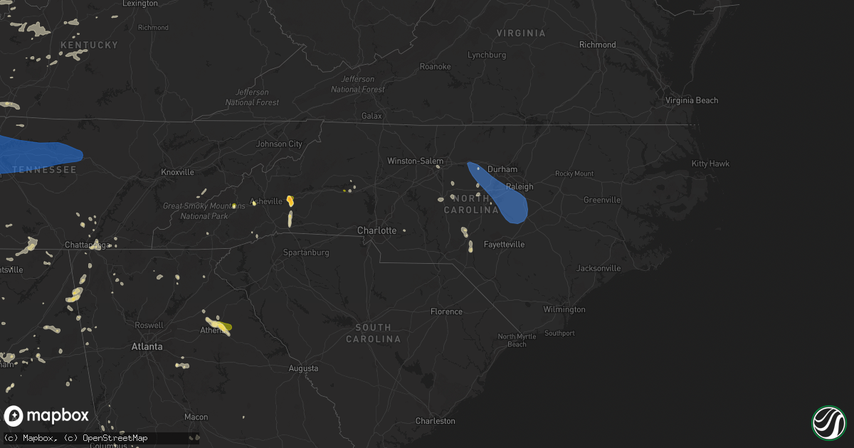
Hail Map in North Carolina on July 1, 2023
Get this storm
July 1 map
$229
one time, instant access
Download today. No call, no setup
Keep the $229
Bought the map and want the full workflow? Apply the entire $229 to a subscription within 7 days. None of it is wasted.
Every map, not just this one
This buys you this map. Subscription and you get every map we run, in the markets you choose from a few cities to whole states to nationwide. Plus real-time alerts the moment a storm fires.
Contact data
Name, contact info, occupancy, even credit band for addresses in the footprint. You go from where it hit to who to call.
Become the source they trust
Unlimited branding weather history reports on demand. You already have the documented answer ready for the property owner, and you are the one who showed up with it.
Property data and RoofTrace estimates
Pull up any address you have got, its value and the exact code rules for that jurisdiction, straight from One Click Code. Then RoofTrace estimates the squares, pitch, and roof value, priced the way you price.
Storm reports in North Carolina
North Carolina
| Date | Description |
|---|---|
| 07/01/20236:27 PM CDT | Tree down at the 3000 block of linden rd. |
| 07/01/20236:20 PM CDT | Tree down on high pines church road. |
| 07/01/20236:19 PM CDT | Tree down at n knoll rd and steeplechase way. |
| 07/01/20236:15 PM CDT | Trees and branches fell on a transformer... Causing it to catch fire. |
| 07/01/20236:05 PM CDT | Tree down on pisgah covered bridge road. |
| 07/01/20236:05 PM CDT | Tree down on ridge road. |
| 07/01/20235:54 PM CDT | Tree down at nc highway 24-27 and plank rd. |
| 07/01/20235:38 PM CDT | 911 call center reports a downed tree blocking the road near greenwood road and joe matthews road. |
| 07/01/20235:35 PM CDT | Tree down on erect road. |
| 07/01/20235:34 PM CDT | Tree down near the intersection of south 13th street and west b street in erwin... Nc. Time estimated by radar. |
| 07/01/20235:30 PM CDT | Trees and powerlines down. |
| 07/01/20235:27 PM CDT | Tree down blocking the roadway along nc 27... In between holder road and autry road. Time estimated by radar. |
| 07/01/20235:20 PM CDT | Trees and powerlines down. Murphy fire responding to live powerlines down on occupied vehicle. |
| 07/01/20235:14 PM CDT | Tree down on a powerline near rosser pittman road and mcneil road. Time estimated by radar. |
| 07/01/20235:12 PM CDT | Penny to nickel size hail with a few larger stones around quarter size mixed in. |
| 07/01/20235:05 PM CDT | A tree was reported down near the intersection of rosser rd and lydia perry rd. Time estimated by radar. |
| 07/01/20234:55 PM CDT | A tree was reported down near the intersection of pittsboro goldston rd and dewitt smith rd. Time estimated by radar. |
| 07/01/20234:54 PM CDT | Social media picture of a tree down on power lines across balls creek rd near edwards rd. |
| 07/01/20234:44 PM CDT | A tree was reported down near the intersection of moncure pittsb |
| 07/01/20234:44 PM CDT | A tree was reported down near the intersection of moncure pittsboro rd and highway us-1. Time estimated by radar. |
| 07/01/20234:20 PM CDT | Multiple trees down near grays chapel including a tree down on route 22 and another on old liberty road. |
| 07/01/20234:15 PM CDT | Corrects time from previous tstm wnd dmg report from 4 w liberty. Tree down near ramseur julian road. |
| 07/01/20234:14 PM CDT | Emergency manager reports a tree down across the roadway near the intersection of dairlyland rd and triple crown dr. Time estimated by radar. |
| 07/01/20234:13 PM CDT | Multiple trees down on utility equipment in franklin. |
| 07/01/20234:08 PM CDT | Emergency manager reports a tree was down across the roadway near the 2100 block of moorefields rd in efland. Time estimated by radar. |
| 07/01/20234:06 PM CDT | Large tree down on powerlines near the intersection of katie lane and nc highway 54. Time estimated by radar. |
| 07/01/20233:50 PM CDT | 1 tree down on r dean coleman road. |
| 07/01/20233:50 PM CDT | 1 tree down at friendship rock creek rd and boyd wright rd. |
| 07/01/20233:47 PM CDT | Multiple trees down on nc-49. |
| 07/01/20233:45 PM CDT | 1 tree down at dr pickett rd and friendship patterson mill rd. |
| 07/01/20233:43 PM CDT | Emergency manger reports numerous trees down across alamance... With one tree involving a car. No injuries were reported. Time estimated by radar. |
| 07/01/20233:40 PM CDT | 1 tree down on pond rd. |
| 07/01/20233:16 PM CDT | Multiple reports of trees and powerlines down between aberdeen... Southern pines... And pinehurst. Time estimated by radar. |
| 07/01/20232:52 PM CDT | A tree at a golf course was split by the wind. Other limbs also downed in the area. |
| 07/01/20232:52 PM CDT | The hail came down as icy slush of various sizes from pea sized up to around quarter sized. |
| 07/01/20232:43 PM CDT | Tree down on hannah ford rd near green rd. |
| 07/01/20232:36 PM CDT | Trees and power lines down across the mill spring area. |
| 07/01/20232:30 PM CDT | Emergency manager reports trees down on residence. |
| 07/01/20232:26 PM CDT | Several trees down along lake adger parkway. |
| 07/01/20232:18 PM CDT | Numerous trees and power lines down in the sunny view community. |
| 07/01/20232:09 PM CDT | Trees down on island creek rd. |
| 07/01/20232:09 PM CDT | Social media picture of trees down near lake lure. Nickel size hail also reported. |
| 07/01/20232:04 PM CDT | Trees down on buffalo shoals rd. |
| 07/01/20231:31 PM CDT | Social media picture of 1 inch hail in candler. |
| 07/01/20231:31 PM CDT | Social media picture of 1 inch hail in |
| 07/01/20231:30 PM CDT | Corrects time of previous tstm wnd dmg report from 3 nnw bent creek. Tree down on power lines along sand hill rd. |
| 07/01/20231:30 PM CDT | Trees down in the 93 block of old us 19 23. |
| 07/01/20231:29 PM CDT | Trees down near 2151 smokey park highway. |
| 07/01/20231:28 PM CDT | Tree fell on a car near 66 justice ridge rd. No injuries reported... But tree blocking both lanes of the road. |
| 07/01/20231:25 PM CDT | Picture of 2 inch hail measured by the emergency manager. |
| 07/01/20231:24 PM CDT | Social media picture of quarter size hail in old fort. |
| 07/01/20231:18 PM CDT | Numerous trees down. Also hail reported near maggie valley but no report of the size of the hail. |
| 07/01/20231:17 PM CDT | Social media picture of quarter size hail in maggie valley. |
| 07/01/20231:16 PM CDT | Trees down in the 1700 block of old us highway 70. |
| 07/01/20231:04 PM CDT | Quarter size hail reported by cocorahs observer. |
| 07/01/202312:30 PM CDT | Tree down on power lines along sand hill rd. |
| 06/30/20237:00 PM CDT | Trees down and roof damage. |
All States Impacted by Hail Map on July 1, 2023
Cities Impacted by Hail Map on July 1, 2023
- Springer, NM
- Gladstone, NM
- Roy, NM
- Waldron, IN
- Shelbyville, IN
- Greensburg, IN
- Hope, IN
- Hartsville, IN
- Bogue, KS
- Stockton, KS
- Penokee, KS
- Damar, KS
- Hill City, KS
- Alton, KS
- Colby, KS
- Rexford, KS
- Paradise, KS
- Plainville, KS
- Brewster, KS
- Edson, KS
- Hoxie, KS
- Kanorado, KS
- Osborne, KS
- Goodland, KS
- Natoma, KS
- Gem, KS
- Woodston, KS
- Morland, KS
- Waldo, KS
- Levant, KS
- Palco, KS
- Selden, KS
- Alpena, AR
- Omaha, AR
- Kirbyville, MO
- Hurricane Mills, TN
- Waverly, TN
- Nunnelly, TN
- McEwen, TN
- Dickson, TN
- Bon Aqua, TN
- Burns, TN
- White Bluff, TN
- Kingston Springs, TN
- Fairview, TN
- Nashville, TN
- Pegram, TN
- Franklin, TN
- Antioch, TN
- Brentwood, TN
- Only, TN
- Lyles, TN
- Hermitage, TN
- Old Hickory, TN
- Mount Juliet, TN
- Madison, TN
- La Vergne, TN
- West Plains, MO
- Golden Gate, IL
- Gainesville, MO
- Zanoni, MO
- Salvisa, KY
- Harrodsburg, KY
- Parsons, TN
- Sugar Tree, TN
- Linden, TN
- Dora, MO
- Dover, TN
- Cumberland City, TN
- Waynesville, NC
- Tecumseh, MO
- Hardenville, MO
- Palmyra, TN
- Indian Mound, TN
- Owensville, IN
- Cynthiana, IN
- Fort Branch, IN
- Thornfield, MO
- Griffin, IN
- Mount Carmel, IL
- Stewart, TN
- Tennessee Ridge, TN
- Erin, TN
- Savannah, TN
- Courtland, AL
- Browns, IL
- Five Points, TN
- Anderson, AL
- Lexington, AL
- Mansfield, TN
- Jackson, TN
- Pulaski, TN
- Ethridge, TN
- Henderson, TN
- Toone, TN
- Gadsden, TN
- Medina, TN
- Oakfield, TN
- Humboldt, TN
- Bells, TN
- Portland, TN
- Bethpage, TN
- Petersburg, IN
- West Salem, IL
- Iuka, MS
- Theodosia, MO
- Protem, MO
- Allendale, IL
- Saint Francisville, IL
- Sumner, IL
- Town Creek, AL
- Cedarcreek, MO
- Green Forest, AR
- Lead Hill, AR
- Cumberland Furnace, TN
- Waynesboro, TN
- Hohenwald, TN
- Martin, TN
- Rives, TN
- Bath Springs, TN
- Clifton, TN
- Alma, NE
- Poseyville, IN
- Pocahontas, AR
- Rutherford, TN
- Newbern, TN
- Kenton, TN
- Dyer, TN
- Woodburn, KY
- Franklin, KY
- Bowling Green, KY
- Leoma, TN
- Mount Pleasant, TN
- Counce, TN
- Albion, IL
- Finger, TN
- Enville, TN
- Bethel Springs, TN
- Bristow, IN
- Tell City, IN
- Saint Meinrad, IN
- Crenshaw, MS
- Como, MS
- Sardis, MS
- Olivehill, TN
- Primm Springs, TN
- Elkmont, AL
- Elizabethtown, KY
- Cecilia, KY
- Harned, KY
- Hardinsburg, KY
- Grayville, IL
- Mount Erie, IL
- Decker, IN
- Robert Lee, TX
- Hampshire, TN
- Columbia, TN
- Gaylord, KS
- South Fulton, TN
- Dukedom, TN
- Haubstadt, IN
- Holland, IN
- Stendal, IN
- Stephensport, KY
- Union Star, KY
- Cannelton, IN
- Derby, IN
- Leopold, IN
- Newport, AR
- Medon, TN
- Alamo, TN
- Prim, AR
- Deer Lodge, MT
- Oakland City, IN
- Tipton, IN
- Dale, IN
- Dyersburg, TN
- Lobelville, TN
- Centerville, TN
- Holladay, TN
- Batesville, MS
- Winslow, IN
- Rossville, TN
- Moscow, TN
- Red Banks, MS
- Coldwater, MS
- Holly Springs, MS
- Byhalia, MS
- Senatobia, MS
- Lamar, MS
- Isabella, MO
- Bone Gap, IL
- Lexington, TN
- Charlotte, TN
- Southside, TN
- Cunningham, TN
- Clarksville, TN
- Ashland City, TN
- Adamsville, TN
- Bolivar, TN
- Huntingburg, IN
- Tennyson, IN
- Parkersburg, IL
- Summertown, TN
- Mountain Home, AR
- Union City, TN
- Trimble, TN
- Sharon, TN
- Athens, AL
- Sardis, TN
- Auburn, KY
- Scottsville, KY
- Branchville, IN
- Ferdinand, IN
- Santa Claus, IN
- Lincoln City, IN
- Caulfield, MO
- Maynard, AR
- Imboden, AR
- Ripley, TN
- Olney, IL
- New Johnsonville, TN
- Westport, TN
- Ellery, IL
- Covington, TN
- Henning, TN
- Brownsville, TN
- Prospect, TN
- Calhoun, IL
- Elberfeld, IN
- Princeton, IN
- Patoka, IN
- Bellmont, IL
- Hazleton, IN
- Francisco, IN
- Lamar, IN
- Gentryville, IN
- Velpen, IN
- Decaturville, TN
- Lynnville, IN
- Lawrenceburg, TN
- Big Sandy, TN
- Springville, TN
- Vanleer, TN
- Chapmansboro, TN
- Pleasant View, TN
- Goodlettsville, TN
- Springfield, TN
- Joelton, TN
- Greenbrier, TN
- Cedar Hill, TN
- Whites Creek, TN
- Gallatin, TN
- Hendersonville, TN
- Nolensville, TN
- Murfreesboro, TN
- Lascassas, TN
- Lebanon, TN
- Smyrna, TN
- Castalian Springs, TN
- Watertown, TN
- Carthage, TN
- Riddleton, TN
- Hartsville, TN
- Brush Creek, TN
- Liberty, TN
- Auburntown, TN
- Alexandria, TN
- Gordonsville, TN
- Milton, TN
- Dowelltown, TN
- Pleasant Shade, TN
- Hickman, TN
- Lancaster, TN
- Elmwood, TN
- Old Fort, NC
- Bloomington Springs, TN
- Buffalo Valley, TN
- Chestnut Mound, TN
- Granville, TN
- Cookeville, TN
- Gainesboro, TN
- Baxter, TN
- Silver Point, TN
- Smithville, TN
- Salem, MO
- Rector, AR
- Piggott, AR
- Holcomb, MO
- Van Buren, MO
- Fremont, MO
- Coulterville, IL
- Oakdale, IL
- Nashville, IL
- Pinckneyville, IL
- Du Quoin, IL
- Tamaroa, IL
- Du Bois, IL
- Elkville, IL
- Murphysboro, IL
- Vergennes, IL
- De Soto, IL
- Grandin, MO
- Salt Flat, TX
- Fredericksburg, VA
- King George, VA
- Maryland Heights, MO
- Saint Louis, MO
- Ballwin, MO
- Chesterfield, MO
- Bridgeton, MO
- Earth City, MO
- Hazelwood, MO
- Saint Ann, MO
- Florissant, MO
- Hartford, IL
- East Saint Louis, IL
- Caseyville, IL
- Lovejoy, IL
- Fairview Heights, IL
- East Alton, IL
- Venice, IL
- Collinsville, IL
- Madison, IL
- Granite City, IL
- Wood River, IL
- Rolla, MO
- Lenox, MO
- Licking, MO
- Edgar Springs, MO
- Saint James, MO
- Cook Sta, MO
- Steelville, MO
- Wesco, MO
- Leasburg, MO
- Cherryville, MO
- Bourbon, MO
- Sullivan, MO
- Saint Clair, MO
- Union, MO
- Robertsville, MO
- Lonedell, MO
- Luebbering, MO
- Richwoods, MO
- Potosi, MO
- Grubville, MO
- Davisville, MO
- West Frankfort, IL
- Carlyle, IL
- Batchtown, IL
- Hardin, IL
- Hamburg, IL
- Eldred, IL
- Maryville, IL
- South Roxana, IL
- Troy, IL
- Edwardsville, IL
- Alhambra, IL
- Hamel, IL
- Glen Carbon, IL
- Roxana, IL
- Worden, IL
- O'Fallon, IL
- Highland, IL
- Marine, IL
- Saint Jacob, IL
- Pocahontas, IL
- New Douglas, IL
- Sorento, IL
- Greenville, IL
- Lebanon, IL
- Kampsville, IL
- Pecos, TX
- Mentone, TX
- Rochelle, TX
- Snow Camp, NC
- Liberty, NC
- Haw River, NC
- Burlington, NC
- Mebane, NC
- Graham, NC
- Chapel Hill, NC
- Hillsborough, NC
- Carrboro, NC
- Efland, NC
- Pittsboro, NC
- Fuquay Varina, NC
- Holly Springs, NC
- Apex, NC
- New Hill, NC
- Moncure, NC
- Cary, NC
- Raleigh, NC
- Garner, NC
- Durham, NC
- Gideon, MO
- Goldsmith, TX
- Lindsborg, KS
- Salina, KS
- Assaria, KS
- Gypsum, KS
- Willow Springs, MO
- Benton, IL
- Campbell, MO
- Parma, MO
- Malden, MO
- Jal, NM
- Hickory, NC
- Abilene, KS
- Solomon, KS
- Lillington, NC
- Willow Spring, NC
- Angier, NC
- Bunnlevel, NC
- Dunn, NC
- Coats, NC
- Erwin, NC
- Clayton, NC
- Four Oaks, NC
- Benson, NC
- Waco, TX
- Riesel, TX
- Mart, TX
- Eunice, NM
- Ashley, IL
- Mount Vernon, IL
- Waltonville, IL
- Woodlawn, IL
- Opdyke, IL
- Scheller, IL
- Keenes, IL
- Bluford, IL
- Wayne City, IL
- Sims, IL
- Ina, IL
- Belle Rive, IL
- Bonnie, IL
- Dahlgren, IL
- Fairfield, IL
- Barnhill, IL
- Burnt Prairie, IL
- Mill Shoals, IL
- Carmi, IL
- McLeansboro, IL
- Springerton, IL
- Crossville, IL
- Enfield, IL
- Jonesboro, IL
- Olive Branch, IL
- Tamms, IL
- Pulaski, IL
- Thebes, IL
- Ullin, IL
- Dongola, IL
- Scott City, MO
- Villa Ridge, IL
- Mounds, IL
- Chaffee, MO
- McClure, IL
- Anna, IL
- Grand Chain, IL
- Cypress, IL
- Karnak, IL
- New Burnside, IL
- Carrier Mills, IL
- Creal Springs, IL
- Goreville, IL
- Ozark, IL
- Simpson, IL
- Belknap, IL
- Olmsted, IL
- Vienna, IL
- Buncombe, IL
- Stonefort, IL
- Herod, IL
- Eddyville, IL
- Grantsburg, IL
- Harrisburg, IL
- Golconda, IL
- Cairo, IL
- Benton, MO
- Miller City, IL
- Cape Girardeau, MO
- Eldorado, IL
- Equality, IL
- Junction, IL
- Vincennes, IN
- Wheatland, IN
- Monroe City, IN
- Boonville, IN
- Evansville, IN
- Chandler, IN
- Wadesville, IN
- New Harmony, IN
- Hobbs, NM
- Monument, NM
- Hull, GA
- Comer, GA
- Danielsville, GA
- Colbert, GA
- Winterville, GA
- Annapolis, IL
- Powell, WY
- Clancy, MT
- Jefferson City, MT
- Gorham, IL
- Beckemeyer, IL
- Orleans, NE
- Conover, NC
- Ava, IL
- Tecumseh, NE
- Hodges, AL
- Houston, MO
- Cabool, MO
- Bucyrus, MO
- Success, MO
- Mountain Grove, MO
- Seneca, KS
- Mountain Rest, SC
- Graysville, TN
- Flaxville, MT
- Henderson, KY
- Robards, KY
- Melvin, TX
- Livingston, MT
- Franklin, NC
- Covington, GA
- Burke, NY
- Constable, NY
- Nebo, IL
- Harrison, AR
- Burchard, NE
- Siler City, NC
- Thompsonville, IL
- Macedonia, IL
- Dahlonega, GA
- Formoso, KS
- Beloit, KS
- Simpson, KS
- Glasco, KS
- Columbus, NC
- Mill Spring, NC
- Lake Lure, NC
- Rutherfordton, NC
- Birch Tree, MO
- Alton, MO
- Logan, AL
- Moore, ID
- Corning, AR
- Decatur, AL
- Ardmore, TN
- Qulin, MO
- Peace Valley, MO
- Wetmore, KS
- Helena, MT
- Johnson, NE
- Brock, NE
- Cook, NE
- Burlington, WY
- Gadsden, AL
- Fackler, AL
- Stevenson, AL
- Gardendale, AL
- Morris, AL
- Birmingham, AL
- La Fayette, GA
- Chickamauga, GA
- Rock Spring, GA
- Syracuse, NE
- Estillfork, AL
- Belvidere, TN
- Huntland, TN
- New Market, AL
- Esbon, KS
- Vanzant, MO
- Ellsinore, MO
- Poplar Bluff, MO
- Wappapello, MO
- Williamsville, MO
- Soddy Daisy, TN
- Jewell, KS
- Oakland, AR
- Yellville, AR
- Pontiac, MO
- Bull Shoals, AR
- Kissee Mills, MO
- Royalton, IL
- Mulkeytown, IL
- Black Mountain, NC
- Pomona, MO
- Cedar Bluff, AL
- Centre, AL
- Gaylesville, AL
- Saluda, NC
- Drury, MO
- Drasco, AR
- Chattanooga, TN
- Cawker City, KS
- Ellaville, GA
- Buena Vista, GA
- Pinehurst, NC
- West End, NC
- Bee Branch, AR
- Waldron, AR
- Cleveland, AR
- Hattieville, AR
- Doniphan, MO
- Gatewood, MO
- Edgemont, AR
- Hayden, AL
- Blountsville, AL
- Johnston City, IL
- Orient, IL
- Dubois, ID
- Bardwell, KY
- Beattie, KS
- Zalma, MO
- Lowndes, MO
- Gipsy, MO
- Ringgold, GA
- Ooltewah, TN
- Rossville, GA
- Sylvan Grove, KS
- Hunter, KS
- Fieldon, IL
- Jerseyville, IL
- Brownsboro, AL
- Warm Springs, AR
- Richview, IL
- Marissa, IL
- Sparta, IL
- Addieville, IL
- Tilden, IL
- Hoyleton, IL
- Lenzburg, IL
- Oak Ridge, MO
- Anderson, SC
- Huggins, MO
- Plato, MO
- Graff, MO
- Brady, TX
- Gatlinburg, TN
- Viburnum, MO
- Le Roy, NY
- Baileyton, AL
- Joppa, AL
- Sesser, IL
- Liberty, NE
- East Helena, MT
- Neelyville, MO
- Kennett, MO
- Portageville, MO
- Gibson, MO
- Pollard, AR
- Lafe, AR
- Saint Francis, AR
- Clarkton, MO
- Greenway, AR
- Trinity, AL
- Moulton, AL
- Danville, AL
- Parrish, AL
- Ellis, KS
- Hays, KS
- Staunton, VA
- Middlebrook, VA
- Swoope, VA
- Robinson, IL
- Hutsonville, IL
- Palestine, IL
- Tiptonville, TN
- Hickman, KY
- Loretto, TN
- Tallapoosa, GA
- Buchanan, GA
- Cleveland, TN
- Lutts, TN
- Jamestown, NC
- Greensboro, NC
- Dunlap, TN
- Signal Mountain, TN
- Palmer, TN
- Cypress Inn, TN
- Cave Spring, GA
- Higden, AR
- Bartelso, IL
- Candler, NC
- Mansfield, GA
- Lyerly, GA
- Summerville, GA
- Menlo, GA
- Arley, AL
- Iron City, TN
- Moody, MO
- Bakersfield, MO
- Couch, MO
- Cherokee, AL
- Whitwell, TN
- Hixson, TN
- Glenallen, MO
- Maggie Valley, NC
- Florence, AL
- Claremont, NC
- Cedartown, GA
- Crossville, AL
- Phil Campbell, AL
- Spruce Pine, AL
- Resaca, GA
- Ranger, GA
- Calhoun, GA
- Pell City, AL
- Cropwell, AL
- Red Bay, AL
- Vina, AL
- Russellville, AL
- Peel, AR
- Greenville, SC
- Easley, SC
- Kirwin, KS
- Greenville, VA
- Pottersville, MO
- Mount Judea, AR
- Kensington, KS
- Cedar, KS
- Moody, AL
- Odenville, AL
- Trussville, AL
- Leeds, AL
- Haleyville, AL
- Double Springs, AL
- Big Lake, TX
- Westpoint, TN
- Bernie, MO
- Essex, MO
- Dexter, MO
- Frohna, MO
- Uniontown, MO
- Jacob, IL
- Altenburg, MO
- Cordova, AL
- Jamestown, KS
- Concordia, KS
- Central, SC
- Trion, GA
- Apison, TN
- Vinemont, AL
- Belmont, MS
- Hamilton, AL
- Golden, MS
- Rockmart, GA
- Dora, AL
- Flintstone, GA
- Keyesport, IL
- Ramseur, NC
- Cullman, AL
- Garden City, TX
- Marble Hill, MO
- Taylorsville, NC
- Piedmont, AL
- Jacksonville, AL
- Duck River, TN
- Rappahannock Academy, VA
- Denmark, TN
- Cutler, IL
- Chatsworth, GA
- Dalton, GA
- Carterville, IL
- Logan, IL
- Herrin, IL
- Hurst, IL
- Zeigler, IL
- Midland, TX
- Buckingham, VA
- Killen, AL
- Collinwood, TN
- Rockwood, IL
- Biggers, AR
- Franklinville, NC
- Climax, NC
- Tuscumbia, AL
- Havana, AR
- Clarkridge, AR
- Piedmont, SC
- Ashville, AL
- Brookwood, AL
- Brevard, NC
- Brandsville, MO
- Koshkonong, MO
- Waterloo, AL
- Pickens, SC
- Somerville, TN
- Winfield, AL
- Guin, AL
- Saint Charles, MO
- Elsberry, MO
- Foley, MO
- Winfield, MO
- New Madrid, MO
- East Prairie, MO
- Ava, MO
- Norwood, MO
- Goodspring, TN
- Anniston, AL
- Cisne, IL
- Andrews, TX
- Jerusalem, AR
- Hector, AR
- Shirley, AR
- Fayetteville, TN
- Aberdeen, NC
- Heflin, AL
- Adairsville, GA
- Huntsville, AL
- Meridianville, AL
- Carrollton, IL
- Hanceville, AL
- Marshall, AR
- Sanford, NC
- Ragland, AL
- Rochester, NY
- Odessa, TX
- Benton, KY
- Calvert City, KY
- Gilbertsville, KY
- Spurgeon, IN
- Loogootee, IN
- Jasper, IN
- Washington, IN
- Cannelburg, IN
- Montgomery, IN
- Otwell, IN
- Eddyville, KY
- Kuttawa, KY
- Grand Rivers, KY
- Dawson Springs, KY
- Princeton, KY
- Butler, MO
- Lexington, GA
- Crawford, GA
- Culloden, GA
- Monticello, GA
- Madison, GA
- Watkinsville, GA
- Forsyth, GA
- Shady Dale, GA
- Shoals, IN
- Dubois, IN
- French Lick, IN
- Saint Anthony, IN
- Birdseye, IN
- Schnellville, IN
- Celestine, IN
- Cerulean, KY
- Midkiff, TX
- Campbellsburg, IN
- Paoli, IN
- West Baden Springs, IN
- Mitchell, IN
- Orleans, IN
- English, IN
- Hardinsburg, IN
- Carpio, ND
- Donnybrook, ND
- Clinton, MO
- Deepwater, MO
- Warsaw, MO
- Lovington, NM
- Mcdonald, NM
- Tatum, NM
- Bottineau, ND
- Souris, ND
- Willow City, ND
- Dunseith, ND
- Rolette, ND
- Owensville, MO
- Berger, MO
- Hermann, MO
- New Haven, MO
- Gerald, MO
- Washington, MO
- Marthasville, MO
- Augusta, MO
- Foristell, MO
- Defiance, MO
- Schell City, MO
- Walker, MO
- Concordia, MO
- Lansford, ND
- Dayton, WY
- Richmond, KS
- Garnett, KS
- Wilsonville, AL
- Columbiana, AL
- Raeford, NC
- Wagram, NC
- Clinton, KY
- Cottondale, AL
- Bonaire, GA
- Warner Robins, GA
- Nicholson, GA
- Creighton, MO
- Garden City, MO
- Harrisonville, MO
- Archie, MO
- Childersburg, AL
- Lincoln, MO
- Edwards, MO
- Boaz, KY
- Paducah, KY
- Mercer, TN
- Pleasanton, KS
- Waverly Hall, GA
- Midland, GA
- Ellerslie, GA
- Stanfield, NC
- Holton, IN
- Dawson, GA
- Boonville, MO
- Nelson, MO
- Pilot Grove, MO
- Blackwater, MO
- Moundville, AL
- Adrian, MO
- Big Timber, MT
- Sycamore, GA
- Medicine Lake, MT
- Homestead, MT
- Columbus, GA
- Fort Benning, GA
- Mound City, KS
- Fredonia, KY
- Circle, MT
- Mason, TX
- Rich Hill, MO
- Rockville, MO
- Sweet Springs, MO
- La Monte, MO
- Athens, GA
- Pinson, AL
- Tennille, GA
- Talladega, AL
- Lincoln, AL
- Fulton, KY
- Ellijay, GA
- Montrose, MO
- Bainbridge, GA
- Wedowee, AL
- Fontana, KS
- Paola, KS
- La Cygne, KS
- Hume, MO
- East Lynne, MO
- Brookville, IN
- Scobey, MT
- Amoret, MO
- Amsterdam, MO
- Brockton, MT
- Reserve, MT
- Hudson, KY
- Arnoldsville, GA
- Plains, GA
- Williamsburg, KS
- Newton, NC
- Stockton, MO
- Houstonia, MO
- Dryden, TX
- Mapleton, KS
- Foster, MO
- Richards, MO
- Fulton, KS
- Prescott, KS
- Blue Mound, KS
- Fort Scott, KS
- Parker, KS
- Centerville, KS
- Hagarville, AR
- Clarksville, MO
- Cusseta, GA
- Preston, GA
- San Saba, TX
- West York, IL
- Big Clifty, KY
- Eastview, KY
- Redstone, MT
- Maljamar, NM
- Asheboro, NC
- Arnegard, ND
- Mauk, GA
- Hughesville, MO
- Sedalia, MO
- Lagrange, GA
- Marston, MO
- Northport, AL
- Adger, AL
- Jefferson, GA
- Ashburn, GA
- Iberia, MO
- Appleton City, MO
- Clarkson, KY
- Duncanville, AL
- Butlerville, IN
- North Vernon, IN
- Lineville, AL
- Fort Valley, GA
- Kathleen, GA
- Box Springs, GA
- Colquitt, GA
- Kennedy, AL
- Reform, AL
- Gordo, AL
- Millport, AL
- Batesville, IN
- Cottonwood, AL
- Campbellton, FL
- Hamilton, GA
- Munford, AL
- Eastaboga, AL
- Chrisney, IN
- Martinsville, IL
- Oblong, IL
- Fairbanks, IN
- Fayette, AL
- Sullivan, IN
- Watford City, ND
- Knoxville, AL
- Commerce, GA
- Cataula, GA
- Okeana, OH
- Appomattox, VA
- Dillwyn, VA
- Gladstone, VA
- Clarkesville, GA
- Fortson, GA
- Tuscaloosa, AL
- Bronwood, GA
- Wolf Point, MT
- Gardendale, TX
- Berry, AL
- Ohatchee, AL
- El Dorado Springs, MO
- Ravenden Springs, AR
- Hickory, KY
- Smithland, KY
- Melber, KY
- Fancy Farm, KY
- Arlington, KY
- Cunningham, KY
- Brookport, IL
- Symsonia, KY
- Ledbetter, KY
- Coolidge, GA
- Pavo, GA
- Bonnieville, KY
- Munfordville, KY
- Magnolia, KY
- Harpersville, AL
- Leitchfield, KY
- Wardell, MO
- Knobel, AR
- Paragould, AR
- Waterloo, IL
- Smithton, IL
- Columbia, IL
- Belleville, IL
- Millstadt, IL
- Freeburg, IL
- Scott Air Force Base, IL
- Mascoutah, IL
- New Baden, IL
- Leeds, ND
- York, ND
- Minnewaukan, ND
- Maddock, ND
- Oxford, OH
- Hamilton, OH
- Kingsville, MO
- Holden, MO
- Cub Run, KY
- Matthews, MO
- Catron, MO
- Marion, KY
- Harwood, MO
- Nevada, MO
- Terre Haute, IN
- Alvaton, KY
- Morrison, MO
- Linn, MO
- Harrison, OH
- Cleves, OH
- Cincinnati, OH
- Irvington, KY
- Garfield, KY
- Pleasant Hill, MO
- Rineyville, KY
- Henley, MO
- Livermore, CO
- Trenton, OH
- Buffalo, KY
- Campbellsville, KY
- Mount Sherman, KY
- Summersville, KY
- Greensburg, KY
- Chamois, MO
- East Carondelet, IL
- Dupo, IL
- Slocomb, AL
- Graceville, FL
- Bardstown, KY
- Dixon, MO
- Custer, KY
- Vine Grove, KY
- Lebanon, KY
- Kevil, KY
- West Chester, OH
- Newburg, MO
- Seagrove, NC
- Lilbourn, MO
- Metropolis, IL
- Asherton, TX
- Bertrand, MO
- Hartford, AL
- Plentywood, MT
- Bonifay, FL
- Roundhill, KY
- Climax Springs, MO
- Lake Village, AR
- New Rockford, ND
- Loretto, KY
- Beaufort, MO
- Esmond, ND
- Hornbeak, TN
- Troy, TN
- Boston, KY
- Greenville, MS
- Willisburg, KY
- Marshall, IL
- West Terre Haute, IN
- New Haven, KY
- New Hope, KY
- Wickliffe, KY
- Leslie, MO
- Shelburn, IN
- Warrenton, MO
- Merom, IN


