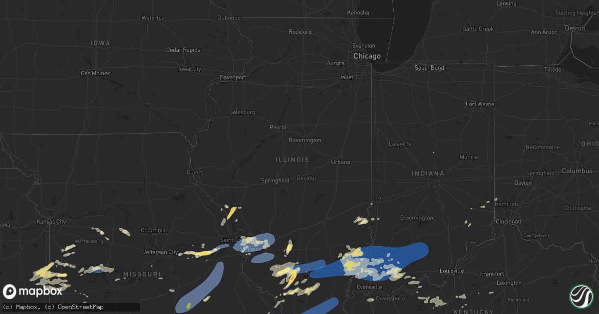
Hail Map in Illinois on July 1, 2023
Get this storm
July 1 map
$229
one time, instant access
Download today. No call, no setup
Keep the $229
Bought the map and want the full workflow? Apply the entire $229 to a subscription within 7 days. None of it is wasted.
Every map, not just this one
This buys you this map. Subscription and you get every map we run, in the markets you choose from a few cities to whole states to nationwide. Plus real-time alerts the moment a storm fires.
Contact data
Name, contact info, occupancy, even credit band for addresses in the footprint. You go from where it hit to who to call.
Become the source they trust
Unlimited branding weather history reports on demand. You already have the documented answer ready for the property owner, and you are the one who showed up with it.
Property data and RoofTrace estimates
Pull up any address you have got, its value and the exact code rules for that jurisdiction, straight from One Click Code. Then RoofTrace estimates the squares, pitch, and roof value, priced the way you price.
Storm reports in Illinois
Illinois
| Date | Description |
|---|---|
| 07/01/20236:35 PM CDT | A local report indicates 59 MPH wind near Mount Carmel Airport |
| 07/01/20236:31 PM CDT | Numerous trees uprooted and snapped. Roof partially blown off of church. Cars slid on the road in the wind. Spotter estimates 80-90 mph. |
| 07/01/20236:19 PM CDT | Two trees fell... Spotter estimated 70 mph winds. |
| 07/01/20236:00 PM CDT | Trees uprooted and snapped. |
| 07/01/20235:51 PM CDT | Trees and powerlines down. |
| 07/01/20235:45 PM CDT | Multiple large trees blown over or snapped. |
| 07/01/20235:36 PM CDT | Trees down county wide. |
| 07/01/20235:20 PM CDT | Rooftop anemometer recorded a 103mph gust. |
| 07/01/20235:19 PM CDT | Trees down on powerlines. |
| 07/01/20235:09 PM CDT | Several trees snapped... Power lines down... Some roof damage. |
| 07/01/20235:01 PM CDT | Multiple large trees down in ashley. Various locations. |
| 07/01/20234:41 PM CDT | Corrects previous hail report from kampsville. |
| 07/01/20234:38 PM CDT | A local report indicates 2.00 inch wind near Kampsville |
| 07/01/20234:38 PM CDT | Roof blown off covered bridge. |
| 07/01/20234:38 PM CDT | Barn blown onto vehicle. |
| 07/01/20234:35 PM CDT | Via twitter with pictures included: roof of marys river covered bridge heavily damaged. |
| 07/01/20234:30 PM CDT | Approximately 40 ft tall tree fell onto bike trail nearby. Did not specify whether tree snapped or was uprooted. |
| 07/01/20234:30 PM CDT | Via facebook with picture included: large tree uprooted and fallen on home. |
| 07/01/20234:25 PM CDT | Multiple tree limbs down. Time estimated from radar. |
| 07/01/20234:22 PM CDT | Quarter sized hail... 3 trees down... Estimated wind 60 mph. |
| 07/01/20234:14 PM CDT | Also 4-5in tree limbs down. |
| 07/01/20234:12 PM CDT | Report from mping: quarter |
| 07/01/20234:11 PM CDT | A local report indicates 1.00 inch wind near 5 SW Keyesport |
| 07/01/20234:11 PM CDT | 2 foo |
| 07/01/20234:11 PM CDT | 2 foot diameter tree snapped. |
| 07/01/20234:10 PM CDT | Delayed report. Trees down southeast of columbia... Il. Received via facebook. |
| 07/01/20234:08 PM CDT | Via facebook with picture included: medium sized tree branch snapped from otherwise healthy tree. |
| 07/01/20234:05 PM CDT | Via email with pictures included: fallen power lines and siding blown off building. |
| 07/01/20234:00 PM CDT | Multiple tree limbs downed. Time estimated from radar. |
| 07/01/20233:58 PM CDT | Power lines down along crystal lake road west of range line road. |
| 07/01/20233:58 PM CDT | Delayed report. Trees down in south roxana... Il via facebook. Time estimated from radar. |
| 07/01/20233:55 PM CDT | Via facebook with pictures and video included: roof ripped off of home furniture store. |
| 07/01/20233:54 PM CDT | Several power poles snapped off around town. |
| 07/01/20233:53 PM CDT | Trees reported down at lodi road and highway 109. Time estimated from radar. |
| 07/01/20233:52 PM CDT | Spotter reported numerous trees down in and around wilson park. |
| 07/01/20233:46 PM CDT | (ls |
| 07/01/20233:46 PM CDT | A local report indicates 60 MPH wind near 1 NE Granite City |
| 07/01/20233:43 PM CDT | Via twitter with picture included: medium to large tree uprooted and laying in street. |
| 07/01/20233:43 PM CDT | Via twitter with pictures included: roof damage to madison meat market. |
| 07/01/20233:42 PM CDT | Pecan tree split... Trampoline lofted and sent some distance. |
| 07/01/20233:25 PM CDT | Report from mping: half dollar |
| 07/01/20233:20 PM CDT | A local report indicates 1.25 inch wind near 2 NNE Tamaroa |
| 07/01/20233:09 PM CDT | A local report indicates 1.75 inch wind near Tamaroa |
| 07/01/20231:13 AM CDT | Via facebook with picture included: numerous small branches snapped from trees... One medium sized branch snapped. |
| 07/01/202312:59 AM CDT | A local report indicates 60 MPH wind near 2 ESE Belleville |
| 07/01/202312:53 AM CDT | Caller reported numerous limbs fallen from trees ranging from small to large in the vicinity of our lady of the snows. |
| 07/01/202312:49 AM CDT | Report from mping: 3-inch tree limbs broken; power poles broken. |
| 07/01/202312:45 AM CDT | Several large trees down... Uprooted... And snapped. Radar signature indicates microburst. |
All States Impacted by Hail Map on July 1, 2023
Cities Impacted by Hail Map on July 1, 2023
- Springer, NM
- Gladstone, NM
- Roy, NM
- Waldron, IN
- Shelbyville, IN
- Greensburg, IN
- Hope, IN
- Hartsville, IN
- Bogue, KS
- Stockton, KS
- Penokee, KS
- Damar, KS
- Hill City, KS
- Alton, KS
- Colby, KS
- Rexford, KS
- Paradise, KS
- Plainville, KS
- Brewster, KS
- Edson, KS
- Hoxie, KS
- Kanorado, KS
- Osborne, KS
- Goodland, KS
- Natoma, KS
- Gem, KS
- Woodston, KS
- Morland, KS
- Waldo, KS
- Levant, KS
- Palco, KS
- Selden, KS
- Alpena, AR
- Omaha, AR
- Kirbyville, MO
- Hurricane Mills, TN
- Waverly, TN
- Nunnelly, TN
- McEwen, TN
- Dickson, TN
- Bon Aqua, TN
- Burns, TN
- White Bluff, TN
- Kingston Springs, TN
- Fairview, TN
- Nashville, TN
- Pegram, TN
- Franklin, TN
- Antioch, TN
- Brentwood, TN
- Only, TN
- Lyles, TN
- Hermitage, TN
- Old Hickory, TN
- Mount Juliet, TN
- Madison, TN
- La Vergne, TN
- West Plains, MO
- Golden Gate, IL
- Gainesville, MO
- Zanoni, MO
- Salvisa, KY
- Harrodsburg, KY
- Parsons, TN
- Sugar Tree, TN
- Linden, TN
- Dora, MO
- Dover, TN
- Cumberland City, TN
- Waynesville, NC
- Tecumseh, MO
- Hardenville, MO
- Palmyra, TN
- Indian Mound, TN
- Owensville, IN
- Cynthiana, IN
- Fort Branch, IN
- Thornfield, MO
- Griffin, IN
- Mount Carmel, IL
- Stewart, TN
- Tennessee Ridge, TN
- Erin, TN
- Savannah, TN
- Courtland, AL
- Browns, IL
- Five Points, TN
- Anderson, AL
- Lexington, AL
- Mansfield, TN
- Jackson, TN
- Pulaski, TN
- Ethridge, TN
- Henderson, TN
- Toone, TN
- Gadsden, TN
- Medina, TN
- Oakfield, TN
- Humboldt, TN
- Bells, TN
- Portland, TN
- Bethpage, TN
- Petersburg, IN
- West Salem, IL
- Iuka, MS
- Theodosia, MO
- Protem, MO
- Allendale, IL
- Saint Francisville, IL
- Sumner, IL
- Town Creek, AL
- Cedarcreek, MO
- Green Forest, AR
- Lead Hill, AR
- Cumberland Furnace, TN
- Waynesboro, TN
- Hohenwald, TN
- Martin, TN
- Rives, TN
- Bath Springs, TN
- Clifton, TN
- Alma, NE
- Poseyville, IN
- Pocahontas, AR
- Rutherford, TN
- Newbern, TN
- Kenton, TN
- Dyer, TN
- Woodburn, KY
- Franklin, KY
- Bowling Green, KY
- Leoma, TN
- Mount Pleasant, TN
- Counce, TN
- Albion, IL
- Finger, TN
- Enville, TN
- Bethel Springs, TN
- Bristow, IN
- Tell City, IN
- Saint Meinrad, IN
- Crenshaw, MS
- Como, MS
- Sardis, MS
- Olivehill, TN
- Primm Springs, TN
- Elkmont, AL
- Elizabethtown, KY
- Cecilia, KY
- Harned, KY
- Hardinsburg, KY
- Grayville, IL
- Mount Erie, IL
- Decker, IN
- Robert Lee, TX
- Hampshire, TN
- Columbia, TN
- Gaylord, KS
- South Fulton, TN
- Dukedom, TN
- Haubstadt, IN
- Holland, IN
- Stendal, IN
- Stephensport, KY
- Union Star, KY
- Cannelton, IN
- Derby, IN
- Leopold, IN
- Newport, AR
- Medon, TN
- Alamo, TN
- Prim, AR
- Deer Lodge, MT
- Oakland City, IN
- Tipton, IN
- Dale, IN
- Dyersburg, TN
- Lobelville, TN
- Centerville, TN
- Holladay, TN
- Batesville, MS
- Winslow, IN
- Rossville, TN
- Moscow, TN
- Red Banks, MS
- Coldwater, MS
- Holly Springs, MS
- Byhalia, MS
- Senatobia, MS
- Lamar, MS
- Isabella, MO
- Bone Gap, IL
- Lexington, TN
- Charlotte, TN
- Southside, TN
- Cunningham, TN
- Clarksville, TN
- Ashland City, TN
- Adamsville, TN
- Bolivar, TN
- Huntingburg, IN
- Tennyson, IN
- Parkersburg, IL
- Summertown, TN
- Mountain Home, AR
- Union City, TN
- Trimble, TN
- Sharon, TN
- Athens, AL
- Sardis, TN
- Auburn, KY
- Scottsville, KY
- Branchville, IN
- Ferdinand, IN
- Santa Claus, IN
- Lincoln City, IN
- Caulfield, MO
- Maynard, AR
- Imboden, AR
- Ripley, TN
- Olney, IL
- New Johnsonville, TN
- Westport, TN
- Ellery, IL
- Covington, TN
- Henning, TN
- Brownsville, TN
- Prospect, TN
- Calhoun, IL
- Elberfeld, IN
- Princeton, IN
- Patoka, IN
- Bellmont, IL
- Hazleton, IN
- Francisco, IN
- Lamar, IN
- Gentryville, IN
- Velpen, IN
- Decaturville, TN
- Lynnville, IN
- Lawrenceburg, TN
- Big Sandy, TN
- Springville, TN
- Vanleer, TN
- Chapmansboro, TN
- Pleasant View, TN
- Goodlettsville, TN
- Springfield, TN
- Joelton, TN
- Greenbrier, TN
- Cedar Hill, TN
- Whites Creek, TN
- Gallatin, TN
- Hendersonville, TN
- Nolensville, TN
- Murfreesboro, TN
- Lascassas, TN
- Lebanon, TN
- Smyrna, TN
- Castalian Springs, TN
- Watertown, TN
- Carthage, TN
- Riddleton, TN
- Hartsville, TN
- Brush Creek, TN
- Liberty, TN
- Auburntown, TN
- Alexandria, TN
- Gordonsville, TN
- Milton, TN
- Dowelltown, TN
- Pleasant Shade, TN
- Hickman, TN
- Lancaster, TN
- Elmwood, TN
- Old Fort, NC
- Bloomington Springs, TN
- Buffalo Valley, TN
- Chestnut Mound, TN
- Granville, TN
- Cookeville, TN
- Gainesboro, TN
- Baxter, TN
- Silver Point, TN
- Smithville, TN
- Salem, MO
- Rector, AR
- Piggott, AR
- Holcomb, MO
- Van Buren, MO
- Fremont, MO
- Coulterville, IL
- Oakdale, IL
- Nashville, IL
- Pinckneyville, IL
- Du Quoin, IL
- Tamaroa, IL
- Du Bois, IL
- Elkville, IL
- Murphysboro, IL
- Vergennes, IL
- De Soto, IL
- Grandin, MO
- Salt Flat, TX
- Fredericksburg, VA
- King George, VA
- Maryland Heights, MO
- Saint Louis, MO
- Ballwin, MO
- Chesterfield, MO
- Bridgeton, MO
- Earth City, MO
- Hazelwood, MO
- Saint Ann, MO
- Florissant, MO
- Hartford, IL
- East Saint Louis, IL
- Caseyville, IL
- Lovejoy, IL
- Fairview Heights, IL
- East Alton, IL
- Venice, IL
- Collinsville, IL
- Madison, IL
- Granite City, IL
- Wood River, IL
- Rolla, MO
- Lenox, MO
- Licking, MO
- Edgar Springs, MO
- Saint James, MO
- Cook Sta, MO
- Steelville, MO
- Wesco, MO
- Leasburg, MO
- Cherryville, MO
- Bourbon, MO
- Sullivan, MO
- Saint Clair, MO
- Union, MO
- Robertsville, MO
- Lonedell, MO
- Luebbering, MO
- Richwoods, MO
- Potosi, MO
- Grubville, MO
- Davisville, MO
- West Frankfort, IL
- Carlyle, IL
- Batchtown, IL
- Hardin, IL
- Hamburg, IL
- Eldred, IL
- Maryville, IL
- South Roxana, IL
- Troy, IL
- Edwardsville, IL
- Alhambra, IL
- Hamel, IL
- Glen Carbon, IL
- Roxana, IL
- Worden, IL
- O'Fallon, IL
- Highland, IL
- Marine, IL
- Saint Jacob, IL
- Pocahontas, IL
- New Douglas, IL
- Sorento, IL
- Greenville, IL
- Lebanon, IL
- Kampsville, IL
- Pecos, TX
- Mentone, TX
- Rochelle, TX
- Snow Camp, NC
- Liberty, NC
- Haw River, NC
- Burlington, NC
- Mebane, NC
- Graham, NC
- Chapel Hill, NC
- Hillsborough, NC
- Carrboro, NC
- Efland, NC
- Pittsboro, NC
- Fuquay Varina, NC
- Holly Springs, NC
- Apex, NC
- New Hill, NC
- Moncure, NC
- Cary, NC
- Raleigh, NC
- Garner, NC
- Durham, NC
- Gideon, MO
- Goldsmith, TX
- Lindsborg, KS
- Salina, KS
- Assaria, KS
- Gypsum, KS
- Willow Springs, MO
- Benton, IL
- Campbell, MO
- Parma, MO
- Malden, MO
- Jal, NM
- Hickory, NC
- Abilene, KS
- Solomon, KS
- Lillington, NC
- Willow Spring, NC
- Angier, NC
- Bunnlevel, NC
- Dunn, NC
- Coats, NC
- Erwin, NC
- Clayton, NC
- Four Oaks, NC
- Benson, NC
- Waco, TX
- Riesel, TX
- Mart, TX
- Eunice, NM
- Ashley, IL
- Mount Vernon, IL
- Waltonville, IL
- Woodlawn, IL
- Opdyke, IL
- Scheller, IL
- Keenes, IL
- Bluford, IL
- Wayne City, IL
- Sims, IL
- Ina, IL
- Belle Rive, IL
- Bonnie, IL
- Dahlgren, IL
- Fairfield, IL
- Barnhill, IL
- Burnt Prairie, IL
- Mill Shoals, IL
- Carmi, IL
- McLeansboro, IL
- Springerton, IL
- Crossville, IL
- Enfield, IL
- Jonesboro, IL
- Olive Branch, IL
- Tamms, IL
- Pulaski, IL
- Thebes, IL
- Ullin, IL
- Dongola, IL
- Scott City, MO
- Villa Ridge, IL
- Mounds, IL
- Chaffee, MO
- McClure, IL
- Anna, IL
- Grand Chain, IL
- Cypress, IL
- Karnak, IL
- New Burnside, IL
- Carrier Mills, IL
- Creal Springs, IL
- Goreville, IL
- Ozark, IL
- Simpson, IL
- Belknap, IL
- Olmsted, IL
- Vienna, IL
- Buncombe, IL
- Stonefort, IL
- Herod, IL
- Eddyville, IL
- Grantsburg, IL
- Harrisburg, IL
- Golconda, IL
- Cairo, IL
- Benton, MO
- Miller City, IL
- Cape Girardeau, MO
- Eldorado, IL
- Equality, IL
- Junction, IL
- Vincennes, IN
- Wheatland, IN
- Monroe City, IN
- Boonville, IN
- Evansville, IN
- Chandler, IN
- Wadesville, IN
- New Harmony, IN
- Hobbs, NM
- Monument, NM
- Hull, GA
- Comer, GA
- Danielsville, GA
- Colbert, GA
- Winterville, GA
- Annapolis, IL
- Powell, WY
- Clancy, MT
- Jefferson City, MT
- Gorham, IL
- Beckemeyer, IL
- Orleans, NE
- Conover, NC
- Ava, IL
- Tecumseh, NE
- Hodges, AL
- Houston, MO
- Cabool, MO
- Bucyrus, MO
- Success, MO
- Mountain Grove, MO
- Seneca, KS
- Mountain Rest, SC
- Graysville, TN
- Flaxville, MT
- Henderson, KY
- Robards, KY
- Melvin, TX
- Livingston, MT
- Franklin, NC
- Covington, GA
- Burke, NY
- Constable, NY
- Nebo, IL
- Harrison, AR
- Burchard, NE
- Siler City, NC
- Thompsonville, IL
- Macedonia, IL
- Dahlonega, GA
- Formoso, KS
- Beloit, KS
- Simpson, KS
- Glasco, KS
- Columbus, NC
- Mill Spring, NC
- Lake Lure, NC
- Rutherfordton, NC
- Birch Tree, MO
- Alton, MO
- Logan, AL
- Moore, ID
- Corning, AR
- Decatur, AL
- Ardmore, TN
- Qulin, MO
- Peace Valley, MO
- Wetmore, KS
- Helena, MT
- Johnson, NE
- Brock, NE
- Cook, NE
- Burlington, WY
- Gadsden, AL
- Fackler, AL
- Stevenson, AL
- Gardendale, AL
- Morris, AL
- Birmingham, AL
- La Fayette, GA
- Chickamauga, GA
- Rock Spring, GA
- Syracuse, NE
- Estillfork, AL
- Belvidere, TN
- Huntland, TN
- New Market, AL
- Esbon, KS
- Vanzant, MO
- Ellsinore, MO
- Poplar Bluff, MO
- Wappapello, MO
- Williamsville, MO
- Soddy Daisy, TN
- Jewell, KS
- Oakland, AR
- Yellville, AR
- Pontiac, MO
- Bull Shoals, AR
- Kissee Mills, MO
- Royalton, IL
- Mulkeytown, IL
- Black Mountain, NC
- Pomona, MO
- Cedar Bluff, AL
- Centre, AL
- Gaylesville, AL
- Saluda, NC
- Drury, MO
- Drasco, AR
- Chattanooga, TN
- Cawker City, KS
- Ellaville, GA
- Buena Vista, GA
- Pinehurst, NC
- West End, NC
- Bee Branch, AR
- Waldron, AR
- Cleveland, AR
- Hattieville, AR
- Doniphan, MO
- Gatewood, MO
- Edgemont, AR
- Hayden, AL
- Blountsville, AL
- Johnston City, IL
- Orient, IL
- Dubois, ID
- Bardwell, KY
- Beattie, KS
- Zalma, MO
- Lowndes, MO
- Gipsy, MO
- Ringgold, GA
- Ooltewah, TN
- Rossville, GA
- Sylvan Grove, KS
- Hunter, KS
- Fieldon, IL
- Jerseyville, IL
- Brownsboro, AL
- Warm Springs, AR
- Richview, IL
- Marissa, IL
- Sparta, IL
- Addieville, IL
- Tilden, IL
- Hoyleton, IL
- Lenzburg, IL
- Oak Ridge, MO
- Anderson, SC
- Huggins, MO
- Plato, MO
- Graff, MO
- Brady, TX
- Gatlinburg, TN
- Viburnum, MO
- Le Roy, NY
- Baileyton, AL
- Joppa, AL
- Sesser, IL
- Liberty, NE
- East Helena, MT
- Neelyville, MO
- Kennett, MO
- Portageville, MO
- Gibson, MO
- Pollard, AR
- Lafe, AR
- Saint Francis, AR
- Clarkton, MO
- Greenway, AR
- Trinity, AL
- Moulton, AL
- Danville, AL
- Parrish, AL
- Ellis, KS
- Hays, KS
- Staunton, VA
- Middlebrook, VA
- Swoope, VA
- Robinson, IL
- Hutsonville, IL
- Palestine, IL
- Tiptonville, TN
- Hickman, KY
- Loretto, TN
- Tallapoosa, GA
- Buchanan, GA
- Cleveland, TN
- Lutts, TN
- Jamestown, NC
- Greensboro, NC
- Dunlap, TN
- Signal Mountain, TN
- Palmer, TN
- Cypress Inn, TN
- Cave Spring, GA
- Higden, AR
- Bartelso, IL
- Candler, NC
- Mansfield, GA
- Lyerly, GA
- Summerville, GA
- Menlo, GA
- Arley, AL
- Iron City, TN
- Moody, MO
- Bakersfield, MO
- Couch, MO
- Cherokee, AL
- Whitwell, TN
- Hixson, TN
- Glenallen, MO
- Maggie Valley, NC
- Florence, AL
- Claremont, NC
- Cedartown, GA
- Crossville, AL
- Phil Campbell, AL
- Spruce Pine, AL
- Resaca, GA
- Ranger, GA
- Calhoun, GA
- Pell City, AL
- Cropwell, AL
- Red Bay, AL
- Vina, AL
- Russellville, AL
- Peel, AR
- Greenville, SC
- Easley, SC
- Kirwin, KS
- Greenville, VA
- Pottersville, MO
- Mount Judea, AR
- Kensington, KS
- Cedar, KS
- Moody, AL
- Odenville, AL
- Trussville, AL
- Leeds, AL
- Haleyville, AL
- Double Springs, AL
- Big Lake, TX
- Westpoint, TN
- Bernie, MO
- Essex, MO
- Dexter, MO
- Frohna, MO
- Uniontown, MO
- Jacob, IL
- Altenburg, MO
- Cordova, AL
- Jamestown, KS
- Concordia, KS
- Central, SC
- Trion, GA
- Apison, TN
- Vinemont, AL
- Belmont, MS
- Hamilton, AL
- Golden, MS
- Rockmart, GA
- Dora, AL
- Flintstone, GA
- Keyesport, IL
- Ramseur, NC
- Cullman, AL
- Garden City, TX
- Marble Hill, MO
- Taylorsville, NC
- Piedmont, AL
- Jacksonville, AL
- Duck River, TN
- Rappahannock Academy, VA
- Denmark, TN
- Cutler, IL
- Chatsworth, GA
- Dalton, GA
- Carterville, IL
- Logan, IL
- Herrin, IL
- Hurst, IL
- Zeigler, IL
- Midland, TX
- Buckingham, VA
- Killen, AL
- Collinwood, TN
- Rockwood, IL
- Biggers, AR
- Franklinville, NC
- Climax, NC
- Tuscumbia, AL
- Havana, AR
- Clarkridge, AR
- Piedmont, SC
- Ashville, AL
- Brookwood, AL
- Brevard, NC
- Brandsville, MO
- Koshkonong, MO
- Waterloo, AL
- Pickens, SC
- Somerville, TN
- Winfield, AL
- Guin, AL
- Saint Charles, MO
- Elsberry, MO
- Foley, MO
- Winfield, MO
- New Madrid, MO
- East Prairie, MO
- Ava, MO
- Norwood, MO
- Goodspring, TN
- Anniston, AL
- Cisne, IL
- Andrews, TX
- Jerusalem, AR
- Hector, AR
- Shirley, AR
- Fayetteville, TN
- Aberdeen, NC
- Heflin, AL
- Adairsville, GA
- Huntsville, AL
- Meridianville, AL
- Carrollton, IL
- Hanceville, AL
- Marshall, AR
- Sanford, NC
- Ragland, AL
- Rochester, NY
- Odessa, TX
- Benton, KY
- Calvert City, KY
- Gilbertsville, KY
- Spurgeon, IN
- Loogootee, IN
- Jasper, IN
- Washington, IN
- Cannelburg, IN
- Montgomery, IN
- Otwell, IN
- Eddyville, KY
- Kuttawa, KY
- Grand Rivers, KY
- Dawson Springs, KY
- Princeton, KY
- Butler, MO
- Lexington, GA
- Crawford, GA
- Culloden, GA
- Monticello, GA
- Madison, GA
- Watkinsville, GA
- Forsyth, GA
- Shady Dale, GA
- Shoals, IN
- Dubois, IN
- French Lick, IN
- Saint Anthony, IN
- Birdseye, IN
- Schnellville, IN
- Celestine, IN
- Cerulean, KY
- Midkiff, TX
- Campbellsburg, IN
- Paoli, IN
- West Baden Springs, IN
- Mitchell, IN
- Orleans, IN
- English, IN
- Hardinsburg, IN
- Carpio, ND
- Donnybrook, ND
- Clinton, MO
- Deepwater, MO
- Warsaw, MO
- Lovington, NM
- Mcdonald, NM
- Tatum, NM
- Bottineau, ND
- Souris, ND
- Willow City, ND
- Dunseith, ND
- Rolette, ND
- Owensville, MO
- Berger, MO
- Hermann, MO
- New Haven, MO
- Gerald, MO
- Washington, MO
- Marthasville, MO
- Augusta, MO
- Foristell, MO
- Defiance, MO
- Schell City, MO
- Walker, MO
- Concordia, MO
- Lansford, ND
- Dayton, WY
- Richmond, KS
- Garnett, KS
- Wilsonville, AL
- Columbiana, AL
- Raeford, NC
- Wagram, NC
- Clinton, KY
- Cottondale, AL
- Bonaire, GA
- Warner Robins, GA
- Nicholson, GA
- Creighton, MO
- Garden City, MO
- Harrisonville, MO
- Archie, MO
- Childersburg, AL
- Lincoln, MO
- Edwards, MO
- Boaz, KY
- Paducah, KY
- Mercer, TN
- Pleasanton, KS
- Waverly Hall, GA
- Midland, GA
- Ellerslie, GA
- Stanfield, NC
- Holton, IN
- Dawson, GA
- Boonville, MO
- Nelson, MO
- Pilot Grove, MO
- Blackwater, MO
- Moundville, AL
- Adrian, MO
- Big Timber, MT
- Sycamore, GA
- Medicine Lake, MT
- Homestead, MT
- Columbus, GA
- Fort Benning, GA
- Mound City, KS
- Fredonia, KY
- Circle, MT
- Mason, TX
- Rich Hill, MO
- Rockville, MO
- Sweet Springs, MO
- La Monte, MO
- Athens, GA
- Pinson, AL
- Tennille, GA
- Talladega, AL
- Lincoln, AL
- Fulton, KY
- Ellijay, GA
- Montrose, MO
- Bainbridge, GA
- Wedowee, AL
- Fontana, KS
- Paola, KS
- La Cygne, KS
- Hume, MO
- East Lynne, MO
- Brookville, IN
- Scobey, MT
- Amoret, MO
- Amsterdam, MO
- Brockton, MT
- Reserve, MT
- Hudson, KY
- Arnoldsville, GA
- Plains, GA
- Williamsburg, KS
- Newton, NC
- Stockton, MO
- Houstonia, MO
- Dryden, TX
- Mapleton, KS
- Foster, MO
- Richards, MO
- Fulton, KS
- Prescott, KS
- Blue Mound, KS
- Fort Scott, KS
- Parker, KS
- Centerville, KS
- Hagarville, AR
- Clarksville, MO
- Cusseta, GA
- Preston, GA
- San Saba, TX
- West York, IL
- Big Clifty, KY
- Eastview, KY
- Redstone, MT
- Maljamar, NM
- Asheboro, NC
- Arnegard, ND
- Mauk, GA
- Hughesville, MO
- Sedalia, MO
- Lagrange, GA
- Marston, MO
- Northport, AL
- Adger, AL
- Jefferson, GA
- Ashburn, GA
- Iberia, MO
- Appleton City, MO
- Clarkson, KY
- Duncanville, AL
- Butlerville, IN
- North Vernon, IN
- Lineville, AL
- Fort Valley, GA
- Kathleen, GA
- Box Springs, GA
- Colquitt, GA
- Kennedy, AL
- Reform, AL
- Gordo, AL
- Millport, AL
- Batesville, IN
- Cottonwood, AL
- Campbellton, FL
- Hamilton, GA
- Munford, AL
- Eastaboga, AL
- Chrisney, IN
- Martinsville, IL
- Oblong, IL
- Fairbanks, IN
- Fayette, AL
- Sullivan, IN
- Watford City, ND
- Knoxville, AL
- Commerce, GA
- Cataula, GA
- Okeana, OH
- Appomattox, VA
- Dillwyn, VA
- Gladstone, VA
- Clarkesville, GA
- Fortson, GA
- Tuscaloosa, AL
- Bronwood, GA
- Wolf Point, MT
- Gardendale, TX
- Berry, AL
- Ohatchee, AL
- El Dorado Springs, MO
- Ravenden Springs, AR
- Hickory, KY
- Smithland, KY
- Melber, KY
- Fancy Farm, KY
- Arlington, KY
- Cunningham, KY
- Brookport, IL
- Symsonia, KY
- Ledbetter, KY
- Coolidge, GA
- Pavo, GA
- Bonnieville, KY
- Munfordville, KY
- Magnolia, KY
- Harpersville, AL
- Leitchfield, KY
- Wardell, MO
- Knobel, AR
- Paragould, AR
- Waterloo, IL
- Smithton, IL
- Columbia, IL
- Belleville, IL
- Millstadt, IL
- Freeburg, IL
- Scott Air Force Base, IL
- Mascoutah, IL
- New Baden, IL
- Leeds, ND
- York, ND
- Minnewaukan, ND
- Maddock, ND
- Oxford, OH
- Hamilton, OH
- Kingsville, MO
- Holden, MO
- Cub Run, KY
- Matthews, MO
- Catron, MO
- Marion, KY
- Harwood, MO
- Nevada, MO
- Terre Haute, IN
- Alvaton, KY
- Morrison, MO
- Linn, MO
- Harrison, OH
- Cleves, OH
- Cincinnati, OH
- Irvington, KY
- Garfield, KY
- Pleasant Hill, MO
- Rineyville, KY
- Henley, MO
- Livermore, CO
- Trenton, OH
- Buffalo, KY
- Campbellsville, KY
- Mount Sherman, KY
- Summersville, KY
- Greensburg, KY
- Chamois, MO
- East Carondelet, IL
- Dupo, IL
- Slocomb, AL
- Graceville, FL
- Bardstown, KY
- Dixon, MO
- Custer, KY
- Vine Grove, KY
- Lebanon, KY
- Kevil, KY
- West Chester, OH
- Newburg, MO
- Seagrove, NC
- Lilbourn, MO
- Metropolis, IL
- Asherton, TX
- Bertrand, MO
- Hartford, AL
- Plentywood, MT
- Bonifay, FL
- Roundhill, KY
- Climax Springs, MO
- Lake Village, AR
- New Rockford, ND
- Loretto, KY
- Beaufort, MO
- Esmond, ND
- Hornbeak, TN
- Troy, TN
- Boston, KY
- Greenville, MS
- Willisburg, KY
- Marshall, IL
- West Terre Haute, IN
- New Haven, KY
- New Hope, KY
- Wickliffe, KY
- Leslie, MO
- Shelburn, IN
- Warrenton, MO
- Merom, IN


