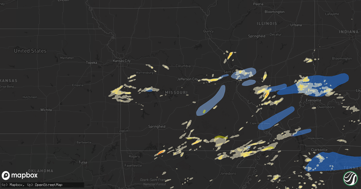
Hail Map in Missouri on July 1, 2023
Get this storm
July 1 map
$229
one time, instant access
Download today. No call, no setup
Keep the $229
Bought the map and want the full workflow? Apply the entire $229 to a subscription within 7 days. None of it is wasted.
Every map, not just this one
This buys you this map. Subscription and you get every map we run, in the markets you choose from a few cities to whole states to nationwide. Plus real-time alerts the moment a storm fires.
Contact data
Name, contact info, occupancy, even credit band for addresses in the footprint. You go from where it hit to who to call.
Become the source they trust
Unlimited branding weather history reports on demand. You already have the documented answer ready for the property owner, and you are the one who showed up with it.
Property data and RoofTrace estimates
Pull up any address you have got, its value and the exact code rules for that jurisdiction, straight from One Click Code. Then RoofTrace estimates the squares, pitch, and roof value, priced the way you price.
Storm reports in Missouri
Missouri
| Date | Description |
|---|---|
| 07/01/20235:32 PM CDT | Trees down on powerlines in new madrid. |
| 07/01/20235:17 PM CDT | Measured at malden municipal airport |
| 07/01/20234:55 PM CDT | A local report indicates 1.00 inch wind near Clarkton |
| 07/01/20234:45 PM CDT | Numerous trees down across town. |
| 07/01/20234:44 PM CDT | Measured at kcgi. |
| 07/01/20234:28 PM CDT | Tree down damaging a vehicle in ste. Genevieve. Time estimated from radar. |
| 07/01/20234:28 PM CDT | 1ft tree limbs down. |
| 07/01/20234:05 PM CDT | Trees down into power lines... And roof and fascia damage to stoddard county ambulance station 4 in puxico. |
| 07/01/20234:01 PM CDT | Via facebook with picture included: tree toppled over. Tree had no substantial root system. |
| 07/01/20234:01 PM CDT | Powerlines down near lake wappapelo. Spotters in the area report 50-60 mph winds. |
| 07/01/20234:00 PM CDT | Corrects previous tstm wnd dmg report from 3 nne olympian village. Trees down along highway cc and lee pyle road. Time estimated from radar. |
| 07/01/20234:00 PM CDT | Trees down along highway cc and lee pyle road. |
| 07/01/20233:58 PM CDT | Trees down in many locations across st. Francis county... Including bonne terre... Knob lick... And the goose creek lake areas. Time for knob lick estimated from radar. |
| 07/01/20233:58 PM CDT | Tree down on a truck. |
| 07/01/20233:56 PM CDT | 2ft tree toppled. |
| 07/01/20233:53 PM CDT | 1ft diameter branches down at garden baptist church. |
| 07/01/20233:50 PM CDT | Power lines down on larimore rd. |
| 07/01/20233:45 PM CDT | 1.5ft tree snapped in half... Picture via twitter. |
| 07/01/20233:42 PM CDT | Trees down in hillsboro. |
| 07/01/20233:41 PM CDT | 1-2ft trees uprooted... 6in branches snapped. |
| 07/01/20233:40 PM CDT | Resident called in a report of a 10 inch diameter sycamore tree was broken in half about halfway up. |
| 07/01/20233:40 PM CDT | 8 inch diameter tree limb on house. |
| 07/01/20233:38 PM CDT | Report from mping: 3-inch tree limbs broken; power poles broken. |
| 07/01/20233:37 PM CDT | *** 1 fatal *** law enforcement reported a tree fell on a parked car and crushed a vehicle. A woman who was inside the vehicle died. |
| 07/01/20233:35 PM CDT | 6-12in tree limbs down... Power lines down. |
| 07/01/20233:34 PM CDT | Via facebook with picture included: large branch partially split from main branch of tree. |
| 07/01/20233:34 PM CDT | Via facebook with picture included: large branch of tree snapped and fallen on vehicles. |
| 07/01/20233:34 PM CDT | Via twitter with pictures included: several large limbs snapped from trees around the city. |
| 07/01/20233:31 PM CDT | 20 inch diameter tree snapped. |
| 07/01/20233:30 PM CDT | Via facebook with picture included: several small to medium trees branches down in different areas of town. Damage to some outdoor structures. |
| 07/01/20233:28 PM CDT | Multiple large trees down. |
| 07/01/20233:25 PM CDT | Via twitter with picture and video included: a tree branch approximately 2 feet in diameter snapped and fell onto a car. |
| 07/01/20233:25 PM CDT | Tree down at garden baptist church. |
| 07/01/20233:23 PM CDT | Trees down along highway k between st. Clair and sullivan. Time estimated from radar. |
| 07/01/20233:19 PM CDT | Via facebook with picture included: numerous trees down along hwy 185... Hwy k... Hwy 30. Damage to camper in that area due to fallen tree. |
| 07/01/20233:17 PM CDT | 7 inch branches blown down. |
| 07/01/20233:15 PM CDT | Unknown diameter tree blown down. |
| 07/01/20233:10 PM CDT | Numerous campers... Awnings... Trees... And power lines damaged in the woodland lakes community. Time estimated. |
| 07/01/20233:08 PM CDT | Via email with pictures included: maple tree snapped. |
| 07/01/20233:08 PM CDT | Via facebook with picture included: tree toppled over. Does not seem to have substantial root system. |
| 07/01/20233:00 PM CDT | Via twitter with picture included: large tree uprooted. Damaged corner of a home on way down. |
| 07/01/20232:54 PM CDT | Large tree toppled over... Reported via twitter with picture. |
| 07/01/20232:46 PM CDT | Trees down blocking multiple roads in the cherryville area. Time estimated from radar. |
| 07/01/20232:38 PM CDT | Tree top broken off and tree branches downed. |
| 07/01/20232:30 PM CDT | Trees and powerlines down. |
| 07/01/20232:27 PM CDT | A local report indicates 1.00 inch wind near 2 S Salem |
| 07/01/20232:20 PM CDT | Report from social media has pictures showing healthy trees snapped due to thunderstorm wind damage in the rhyse area. |
| 07/01/20232:15 PM CDT | 2 large oak trees and several roofs damaged in the licking area. Time estimated from radar. |
| 07/01/20231:35 PM CDT | Corrects previous hail report from west plains. House windows broken from hail. |
| 07/01/20231:35 PM CDT | Tree branches down on highway 51. |
| 07/01/20231:35 PM CDT | Corrects previous tstm wnd dmg report from west plains. Thunderstorm winds downed tree limbs 6 to 8 inches in diameter. |
| 07/01/20231:32 PM CDT | Thunderstorm winds downed tree limbs 6 to 8 inches in diameter. |
| 07/01/20231:32 PM CDT | A local report indicates 1.00 inch wind near 1 WSW West Plains |
| 07/01/20231:32 PM CDT | House windows broken from hail. |
| 07/01/20231:30 PM CDT | Multiple medium size limbs were knocked down in hartville. A limb fell on power lines knocking power out. A tent in the park in hartville was blown into the lake at the |
| 07/01/20231:30 PM CDT | Reports of powerlines down and tree downed causing damage to a house and barn on county rd 6540 southwest of west plains. |
| 07/01/202312:47 AM CDT | Large tree blown over... Numerous large tree limbs blown down. |
| 07/01/202312:46 AM CDT | Via facebook with picture included: large part of tree snapped from trunk. |
| 07/01/202312:46 AM CDT | Via facebook with pictures included: large tree uprooted and moderately sized branches snapped from trees. |
| 07/01/202312:36 AM CDT | Via facebook with picture included: healthy tree approximately 7 inches in diameter snapped 4 feet up from base. |
| 07/01/202312:36 AM CDT | Photo included: large branch snapped and fallen on parked cars. |
| 07/01/202312:33 AM CDT | Via facebook with picture included: large branch snapped off tree. |
| 07/01/202312:33 AM CDT | Via twitter with picture included: small limbs down in road. No power from 1230 to 9am. |
| 07/01/202312:00 AM CDT | Widespread trees and branches down between augusta and defiance. Reported via social media. Time estimated from radar. |
| 06/30/202311:50 PM CDT | At washington memorial airport... 51kts wind gust. |
| 06/30/202311:44 PM CDT | Via twitter with picture included: several large limbs down in neighborhood. |
| 06/30/202311:32 PM CDT | A local report indicates 1.50 inch wind near 3 SSW New Haven |
| 06/30/202311:15 PM CDT | Wind and hail damage to crops. Pictures received on social media of damage. Time estimated. |
| 06/30/202310:01 PM CDT | Law enforcement reported trees down in roadway near hwy 87 and olean. |
| 06/30/20239:02 PM CDT | Corrects previous tstm wnd dmg report from 5 s wolf island. Trees and powerlines down across the area. Trees down on houses. |
| 06/30/20238:25 PM CDT | A local report indicates 1.00 inch wind near 1 SE Tightwad |
| 06/30/20238:25 PM CDT | A local report indicates 60 MPH wind near 1 SE Tightwad |
| 06/30/20237:20 PM CDT | Public reported multiple rounds quarter size hail and heavy rain. Time estimated via radar. |
All States Impacted by Hail Map on July 1, 2023
Cities Impacted by Hail Map on July 1, 2023
- Springer, NM
- Gladstone, NM
- Roy, NM
- Waldron, IN
- Shelbyville, IN
- Greensburg, IN
- Hope, IN
- Hartsville, IN
- Bogue, KS
- Stockton, KS
- Penokee, KS
- Damar, KS
- Hill City, KS
- Alton, KS
- Colby, KS
- Rexford, KS
- Paradise, KS
- Plainville, KS
- Brewster, KS
- Edson, KS
- Hoxie, KS
- Kanorado, KS
- Osborne, KS
- Goodland, KS
- Natoma, KS
- Gem, KS
- Woodston, KS
- Morland, KS
- Waldo, KS
- Levant, KS
- Palco, KS
- Selden, KS
- Alpena, AR
- Omaha, AR
- Kirbyville, MO
- Hurricane Mills, TN
- Waverly, TN
- Nunnelly, TN
- McEwen, TN
- Dickson, TN
- Bon Aqua, TN
- Burns, TN
- White Bluff, TN
- Kingston Springs, TN
- Fairview, TN
- Nashville, TN
- Pegram, TN
- Franklin, TN
- Antioch, TN
- Brentwood, TN
- Only, TN
- Lyles, TN
- Hermitage, TN
- Old Hickory, TN
- Mount Juliet, TN
- Madison, TN
- La Vergne, TN
- West Plains, MO
- Golden Gate, IL
- Gainesville, MO
- Zanoni, MO
- Salvisa, KY
- Harrodsburg, KY
- Parsons, TN
- Sugar Tree, TN
- Linden, TN
- Dora, MO
- Dover, TN
- Cumberland City, TN
- Waynesville, NC
- Tecumseh, MO
- Hardenville, MO
- Palmyra, TN
- Indian Mound, TN
- Owensville, IN
- Cynthiana, IN
- Fort Branch, IN
- Thornfield, MO
- Griffin, IN
- Mount Carmel, IL
- Stewart, TN
- Tennessee Ridge, TN
- Erin, TN
- Savannah, TN
- Courtland, AL
- Browns, IL
- Five Points, TN
- Anderson, AL
- Lexington, AL
- Mansfield, TN
- Jackson, TN
- Pulaski, TN
- Ethridge, TN
- Henderson, TN
- Toone, TN
- Gadsden, TN
- Medina, TN
- Oakfield, TN
- Humboldt, TN
- Bells, TN
- Portland, TN
- Bethpage, TN
- Petersburg, IN
- West Salem, IL
- Iuka, MS
- Theodosia, MO
- Protem, MO
- Allendale, IL
- Saint Francisville, IL
- Sumner, IL
- Town Creek, AL
- Cedarcreek, MO
- Green Forest, AR
- Lead Hill, AR
- Cumberland Furnace, TN
- Waynesboro, TN
- Hohenwald, TN
- Martin, TN
- Rives, TN
- Bath Springs, TN
- Clifton, TN
- Alma, NE
- Poseyville, IN
- Pocahontas, AR
- Rutherford, TN
- Newbern, TN
- Kenton, TN
- Dyer, TN
- Woodburn, KY
- Franklin, KY
- Bowling Green, KY
- Leoma, TN
- Mount Pleasant, TN
- Counce, TN
- Albion, IL
- Finger, TN
- Enville, TN
- Bethel Springs, TN
- Bristow, IN
- Tell City, IN
- Saint Meinrad, IN
- Crenshaw, MS
- Como, MS
- Sardis, MS
- Olivehill, TN
- Primm Springs, TN
- Elkmont, AL
- Elizabethtown, KY
- Cecilia, KY
- Harned, KY
- Hardinsburg, KY
- Grayville, IL
- Mount Erie, IL
- Decker, IN
- Robert Lee, TX
- Hampshire, TN
- Columbia, TN
- Gaylord, KS
- South Fulton, TN
- Dukedom, TN
- Haubstadt, IN
- Holland, IN
- Stendal, IN
- Stephensport, KY
- Union Star, KY
- Cannelton, IN
- Derby, IN
- Leopold, IN
- Newport, AR
- Medon, TN
- Alamo, TN
- Prim, AR
- Deer Lodge, MT
- Oakland City, IN
- Tipton, IN
- Dale, IN
- Dyersburg, TN
- Lobelville, TN
- Centerville, TN
- Holladay, TN
- Batesville, MS
- Winslow, IN
- Rossville, TN
- Moscow, TN
- Red Banks, MS
- Coldwater, MS
- Holly Springs, MS
- Byhalia, MS
- Senatobia, MS
- Lamar, MS
- Isabella, MO
- Bone Gap, IL
- Lexington, TN
- Charlotte, TN
- Southside, TN
- Cunningham, TN
- Clarksville, TN
- Ashland City, TN
- Adamsville, TN
- Bolivar, TN
- Huntingburg, IN
- Tennyson, IN
- Parkersburg, IL
- Summertown, TN
- Mountain Home, AR
- Union City, TN
- Trimble, TN
- Sharon, TN
- Athens, AL
- Sardis, TN
- Auburn, KY
- Scottsville, KY
- Branchville, IN
- Ferdinand, IN
- Santa Claus, IN
- Lincoln City, IN
- Caulfield, MO
- Maynard, AR
- Imboden, AR
- Ripley, TN
- Olney, IL
- New Johnsonville, TN
- Westport, TN
- Ellery, IL
- Covington, TN
- Henning, TN
- Brownsville, TN
- Prospect, TN
- Calhoun, IL
- Elberfeld, IN
- Princeton, IN
- Patoka, IN
- Bellmont, IL
- Hazleton, IN
- Francisco, IN
- Lamar, IN
- Gentryville, IN
- Velpen, IN
- Decaturville, TN
- Lynnville, IN
- Lawrenceburg, TN
- Big Sandy, TN
- Springville, TN
- Vanleer, TN
- Chapmansboro, TN
- Pleasant View, TN
- Goodlettsville, TN
- Springfield, TN
- Joelton, TN
- Greenbrier, TN
- Cedar Hill, TN
- Whites Creek, TN
- Gallatin, TN
- Hendersonville, TN
- Nolensville, TN
- Murfreesboro, TN
- Lascassas, TN
- Lebanon, TN
- Smyrna, TN
- Castalian Springs, TN
- Watertown, TN
- Carthage, TN
- Riddleton, TN
- Hartsville, TN
- Brush Creek, TN
- Liberty, TN
- Auburntown, TN
- Alexandria, TN
- Gordonsville, TN
- Milton, TN
- Dowelltown, TN
- Pleasant Shade, TN
- Hickman, TN
- Lancaster, TN
- Elmwood, TN
- Old Fort, NC
- Bloomington Springs, TN
- Buffalo Valley, TN
- Chestnut Mound, TN
- Granville, TN
- Cookeville, TN
- Gainesboro, TN
- Baxter, TN
- Silver Point, TN
- Smithville, TN
- Salem, MO
- Rector, AR
- Piggott, AR
- Holcomb, MO
- Van Buren, MO
- Fremont, MO
- Coulterville, IL
- Oakdale, IL
- Nashville, IL
- Pinckneyville, IL
- Du Quoin, IL
- Tamaroa, IL
- Du Bois, IL
- Elkville, IL
- Murphysboro, IL
- Vergennes, IL
- De Soto, IL
- Grandin, MO
- Salt Flat, TX
- Fredericksburg, VA
- King George, VA
- Maryland Heights, MO
- Saint Louis, MO
- Ballwin, MO
- Chesterfield, MO
- Bridgeton, MO
- Earth City, MO
- Hazelwood, MO
- Saint Ann, MO
- Florissant, MO
- Hartford, IL
- East Saint Louis, IL
- Caseyville, IL
- Lovejoy, IL
- Fairview Heights, IL
- East Alton, IL
- Venice, IL
- Collinsville, IL
- Madison, IL
- Granite City, IL
- Wood River, IL
- Rolla, MO
- Lenox, MO
- Licking, MO
- Edgar Springs, MO
- Saint James, MO
- Cook Sta, MO
- Steelville, MO
- Wesco, MO
- Leasburg, MO
- Cherryville, MO
- Bourbon, MO
- Sullivan, MO
- Saint Clair, MO
- Union, MO
- Robertsville, MO
- Lonedell, MO
- Luebbering, MO
- Richwoods, MO
- Potosi, MO
- Grubville, MO
- Davisville, MO
- West Frankfort, IL
- Carlyle, IL
- Batchtown, IL
- Hardin, IL
- Hamburg, IL
- Eldred, IL
- Maryville, IL
- South Roxana, IL
- Troy, IL
- Edwardsville, IL
- Alhambra, IL
- Hamel, IL
- Glen Carbon, IL
- Roxana, IL
- Worden, IL
- O'Fallon, IL
- Highland, IL
- Marine, IL
- Saint Jacob, IL
- Pocahontas, IL
- New Douglas, IL
- Sorento, IL
- Greenville, IL
- Lebanon, IL
- Kampsville, IL
- Pecos, TX
- Mentone, TX
- Rochelle, TX
- Snow Camp, NC
- Liberty, NC
- Haw River, NC
- Burlington, NC
- Mebane, NC
- Graham, NC
- Chapel Hill, NC
- Hillsborough, NC
- Carrboro, NC
- Efland, NC
- Pittsboro, NC
- Fuquay Varina, NC
- Holly Springs, NC
- Apex, NC
- New Hill, NC
- Moncure, NC
- Cary, NC
- Raleigh, NC
- Garner, NC
- Durham, NC
- Gideon, MO
- Goldsmith, TX
- Lindsborg, KS
- Salina, KS
- Assaria, KS
- Gypsum, KS
- Willow Springs, MO
- Benton, IL
- Campbell, MO
- Parma, MO
- Malden, MO
- Jal, NM
- Hickory, NC
- Abilene, KS
- Solomon, KS
- Lillington, NC
- Willow Spring, NC
- Angier, NC
- Bunnlevel, NC
- Dunn, NC
- Coats, NC
- Erwin, NC
- Clayton, NC
- Four Oaks, NC
- Benson, NC
- Waco, TX
- Riesel, TX
- Mart, TX
- Eunice, NM
- Ashley, IL
- Mount Vernon, IL
- Waltonville, IL
- Woodlawn, IL
- Opdyke, IL
- Scheller, IL
- Keenes, IL
- Bluford, IL
- Wayne City, IL
- Sims, IL
- Ina, IL
- Belle Rive, IL
- Bonnie, IL
- Dahlgren, IL
- Fairfield, IL
- Barnhill, IL
- Burnt Prairie, IL
- Mill Shoals, IL
- Carmi, IL
- McLeansboro, IL
- Springerton, IL
- Crossville, IL
- Enfield, IL
- Jonesboro, IL
- Olive Branch, IL
- Tamms, IL
- Pulaski, IL
- Thebes, IL
- Ullin, IL
- Dongola, IL
- Scott City, MO
- Villa Ridge, IL
- Mounds, IL
- Chaffee, MO
- McClure, IL
- Anna, IL
- Grand Chain, IL
- Cypress, IL
- Karnak, IL
- New Burnside, IL
- Carrier Mills, IL
- Creal Springs, IL
- Goreville, IL
- Ozark, IL
- Simpson, IL
- Belknap, IL
- Olmsted, IL
- Vienna, IL
- Buncombe, IL
- Stonefort, IL
- Herod, IL
- Eddyville, IL
- Grantsburg, IL
- Harrisburg, IL
- Golconda, IL
- Cairo, IL
- Benton, MO
- Miller City, IL
- Cape Girardeau, MO
- Eldorado, IL
- Equality, IL
- Junction, IL
- Vincennes, IN
- Wheatland, IN
- Monroe City, IN
- Boonville, IN
- Evansville, IN
- Chandler, IN
- Wadesville, IN
- New Harmony, IN
- Hobbs, NM
- Monument, NM
- Hull, GA
- Comer, GA
- Danielsville, GA
- Colbert, GA
- Winterville, GA
- Annapolis, IL
- Powell, WY
- Clancy, MT
- Jefferson City, MT
- Gorham, IL
- Beckemeyer, IL
- Orleans, NE
- Conover, NC
- Ava, IL
- Tecumseh, NE
- Hodges, AL
- Houston, MO
- Cabool, MO
- Bucyrus, MO
- Success, MO
- Mountain Grove, MO
- Seneca, KS
- Mountain Rest, SC
- Graysville, TN
- Flaxville, MT
- Henderson, KY
- Robards, KY
- Melvin, TX
- Livingston, MT
- Franklin, NC
- Covington, GA
- Burke, NY
- Constable, NY
- Nebo, IL
- Harrison, AR
- Burchard, NE
- Siler City, NC
- Thompsonville, IL
- Macedonia, IL
- Dahlonega, GA
- Formoso, KS
- Beloit, KS
- Simpson, KS
- Glasco, KS
- Columbus, NC
- Mill Spring, NC
- Lake Lure, NC
- Rutherfordton, NC
- Birch Tree, MO
- Alton, MO
- Logan, AL
- Moore, ID
- Corning, AR
- Decatur, AL
- Ardmore, TN
- Qulin, MO
- Peace Valley, MO
- Wetmore, KS
- Helena, MT
- Johnson, NE
- Brock, NE
- Cook, NE
- Burlington, WY
- Gadsden, AL
- Fackler, AL
- Stevenson, AL
- Gardendale, AL
- Morris, AL
- Birmingham, AL
- La Fayette, GA
- Chickamauga, GA
- Rock Spring, GA
- Syracuse, NE
- Estillfork, AL
- Belvidere, TN
- Huntland, TN
- New Market, AL
- Esbon, KS
- Vanzant, MO
- Ellsinore, MO
- Poplar Bluff, MO
- Wappapello, MO
- Williamsville, MO
- Soddy Daisy, TN
- Jewell, KS
- Oakland, AR
- Yellville, AR
- Pontiac, MO
- Bull Shoals, AR
- Kissee Mills, MO
- Royalton, IL
- Mulkeytown, IL
- Black Mountain, NC
- Pomona, MO
- Cedar Bluff, AL
- Centre, AL
- Gaylesville, AL
- Saluda, NC
- Drury, MO
- Drasco, AR
- Chattanooga, TN
- Cawker City, KS
- Ellaville, GA
- Buena Vista, GA
- Pinehurst, NC
- West End, NC
- Bee Branch, AR
- Waldron, AR
- Cleveland, AR
- Hattieville, AR
- Doniphan, MO
- Gatewood, MO
- Edgemont, AR
- Hayden, AL
- Blountsville, AL
- Johnston City, IL
- Orient, IL
- Dubois, ID
- Bardwell, KY
- Beattie, KS
- Zalma, MO
- Lowndes, MO
- Gipsy, MO
- Ringgold, GA
- Ooltewah, TN
- Rossville, GA
- Sylvan Grove, KS
- Hunter, KS
- Fieldon, IL
- Jerseyville, IL
- Brownsboro, AL
- Warm Springs, AR
- Richview, IL
- Marissa, IL
- Sparta, IL
- Addieville, IL
- Tilden, IL
- Hoyleton, IL
- Lenzburg, IL
- Oak Ridge, MO
- Anderson, SC
- Huggins, MO
- Plato, MO
- Graff, MO
- Brady, TX
- Gatlinburg, TN
- Viburnum, MO
- Le Roy, NY
- Baileyton, AL
- Joppa, AL
- Sesser, IL
- Liberty, NE
- East Helena, MT
- Neelyville, MO
- Kennett, MO
- Portageville, MO
- Gibson, MO
- Pollard, AR
- Lafe, AR
- Saint Francis, AR
- Clarkton, MO
- Greenway, AR
- Trinity, AL
- Moulton, AL
- Danville, AL
- Parrish, AL
- Ellis, KS
- Hays, KS
- Staunton, VA
- Middlebrook, VA
- Swoope, VA
- Robinson, IL
- Hutsonville, IL
- Palestine, IL
- Tiptonville, TN
- Hickman, KY
- Loretto, TN
- Tallapoosa, GA
- Buchanan, GA
- Cleveland, TN
- Lutts, TN
- Jamestown, NC
- Greensboro, NC
- Dunlap, TN
- Signal Mountain, TN
- Palmer, TN
- Cypress Inn, TN
- Cave Spring, GA
- Higden, AR
- Bartelso, IL
- Candler, NC
- Mansfield, GA
- Lyerly, GA
- Summerville, GA
- Menlo, GA
- Arley, AL
- Iron City, TN
- Moody, MO
- Bakersfield, MO
- Couch, MO
- Cherokee, AL
- Whitwell, TN
- Hixson, TN
- Glenallen, MO
- Maggie Valley, NC
- Florence, AL
- Claremont, NC
- Cedartown, GA
- Crossville, AL
- Phil Campbell, AL
- Spruce Pine, AL
- Resaca, GA
- Ranger, GA
- Calhoun, GA
- Pell City, AL
- Cropwell, AL
- Red Bay, AL
- Vina, AL
- Russellville, AL
- Peel, AR
- Greenville, SC
- Easley, SC
- Kirwin, KS
- Greenville, VA
- Pottersville, MO
- Mount Judea, AR
- Kensington, KS
- Cedar, KS
- Moody, AL
- Odenville, AL
- Trussville, AL
- Leeds, AL
- Haleyville, AL
- Double Springs, AL
- Big Lake, TX
- Westpoint, TN
- Bernie, MO
- Essex, MO
- Dexter, MO
- Frohna, MO
- Uniontown, MO
- Jacob, IL
- Altenburg, MO
- Cordova, AL
- Jamestown, KS
- Concordia, KS
- Central, SC
- Trion, GA
- Apison, TN
- Vinemont, AL
- Belmont, MS
- Hamilton, AL
- Golden, MS
- Rockmart, GA
- Dora, AL
- Flintstone, GA
- Keyesport, IL
- Ramseur, NC
- Cullman, AL
- Garden City, TX
- Marble Hill, MO
- Taylorsville, NC
- Piedmont, AL
- Jacksonville, AL
- Duck River, TN
- Rappahannock Academy, VA
- Denmark, TN
- Cutler, IL
- Chatsworth, GA
- Dalton, GA
- Carterville, IL
- Logan, IL
- Herrin, IL
- Hurst, IL
- Zeigler, IL
- Midland, TX
- Buckingham, VA
- Killen, AL
- Collinwood, TN
- Rockwood, IL
- Biggers, AR
- Franklinville, NC
- Climax, NC
- Tuscumbia, AL
- Havana, AR
- Clarkridge, AR
- Piedmont, SC
- Ashville, AL
- Brookwood, AL
- Brevard, NC
- Brandsville, MO
- Koshkonong, MO
- Waterloo, AL
- Pickens, SC
- Somerville, TN
- Winfield, AL
- Guin, AL
- Saint Charles, MO
- Elsberry, MO
- Foley, MO
- Winfield, MO
- New Madrid, MO
- East Prairie, MO
- Ava, MO
- Norwood, MO
- Goodspring, TN
- Anniston, AL
- Cisne, IL
- Andrews, TX
- Jerusalem, AR
- Hector, AR
- Shirley, AR
- Fayetteville, TN
- Aberdeen, NC
- Heflin, AL
- Adairsville, GA
- Huntsville, AL
- Meridianville, AL
- Carrollton, IL
- Hanceville, AL
- Marshall, AR
- Sanford, NC
- Ragland, AL
- Rochester, NY
- Odessa, TX
- Benton, KY
- Calvert City, KY
- Gilbertsville, KY
- Spurgeon, IN
- Loogootee, IN
- Jasper, IN
- Washington, IN
- Cannelburg, IN
- Montgomery, IN
- Otwell, IN
- Eddyville, KY
- Kuttawa, KY
- Grand Rivers, KY
- Dawson Springs, KY
- Princeton, KY
- Butler, MO
- Lexington, GA
- Crawford, GA
- Culloden, GA
- Monticello, GA
- Madison, GA
- Watkinsville, GA
- Forsyth, GA
- Shady Dale, GA
- Shoals, IN
- Dubois, IN
- French Lick, IN
- Saint Anthony, IN
- Birdseye, IN
- Schnellville, IN
- Celestine, IN
- Cerulean, KY
- Midkiff, TX
- Campbellsburg, IN
- Paoli, IN
- West Baden Springs, IN
- Mitchell, IN
- Orleans, IN
- English, IN
- Hardinsburg, IN
- Carpio, ND
- Donnybrook, ND
- Clinton, MO
- Deepwater, MO
- Warsaw, MO
- Lovington, NM
- Mcdonald, NM
- Tatum, NM
- Bottineau, ND
- Souris, ND
- Willow City, ND
- Dunseith, ND
- Rolette, ND
- Owensville, MO
- Berger, MO
- Hermann, MO
- New Haven, MO
- Gerald, MO
- Washington, MO
- Marthasville, MO
- Augusta, MO
- Foristell, MO
- Defiance, MO
- Schell City, MO
- Walker, MO
- Concordia, MO
- Lansford, ND
- Dayton, WY
- Richmond, KS
- Garnett, KS
- Wilsonville, AL
- Columbiana, AL
- Raeford, NC
- Wagram, NC
- Clinton, KY
- Cottondale, AL
- Bonaire, GA
- Warner Robins, GA
- Nicholson, GA
- Creighton, MO
- Garden City, MO
- Harrisonville, MO
- Archie, MO
- Childersburg, AL
- Lincoln, MO
- Edwards, MO
- Boaz, KY
- Paducah, KY
- Mercer, TN
- Pleasanton, KS
- Waverly Hall, GA
- Midland, GA
- Ellerslie, GA
- Stanfield, NC
- Holton, IN
- Dawson, GA
- Boonville, MO
- Nelson, MO
- Pilot Grove, MO
- Blackwater, MO
- Moundville, AL
- Adrian, MO
- Big Timber, MT
- Sycamore, GA
- Medicine Lake, MT
- Homestead, MT
- Columbus, GA
- Fort Benning, GA
- Mound City, KS
- Fredonia, KY
- Circle, MT
- Mason, TX
- Rich Hill, MO
- Rockville, MO
- Sweet Springs, MO
- La Monte, MO
- Athens, GA
- Pinson, AL
- Tennille, GA
- Talladega, AL
- Lincoln, AL
- Fulton, KY
- Ellijay, GA
- Montrose, MO
- Bainbridge, GA
- Wedowee, AL
- Fontana, KS
- Paola, KS
- La Cygne, KS
- Hume, MO
- East Lynne, MO
- Brookville, IN
- Scobey, MT
- Amoret, MO
- Amsterdam, MO
- Brockton, MT
- Reserve, MT
- Hudson, KY
- Arnoldsville, GA
- Plains, GA
- Williamsburg, KS
- Newton, NC
- Stockton, MO
- Houstonia, MO
- Dryden, TX
- Mapleton, KS
- Foster, MO
- Richards, MO
- Fulton, KS
- Prescott, KS
- Blue Mound, KS
- Fort Scott, KS
- Parker, KS
- Centerville, KS
- Hagarville, AR
- Clarksville, MO
- Cusseta, GA
- Preston, GA
- San Saba, TX
- West York, IL
- Big Clifty, KY
- Eastview, KY
- Redstone, MT
- Maljamar, NM
- Asheboro, NC
- Arnegard, ND
- Mauk, GA
- Hughesville, MO
- Sedalia, MO
- Lagrange, GA
- Marston, MO
- Northport, AL
- Adger, AL
- Jefferson, GA
- Ashburn, GA
- Iberia, MO
- Appleton City, MO
- Clarkson, KY
- Duncanville, AL
- Butlerville, IN
- North Vernon, IN
- Lineville, AL
- Fort Valley, GA
- Kathleen, GA
- Box Springs, GA
- Colquitt, GA
- Kennedy, AL
- Reform, AL
- Gordo, AL
- Millport, AL
- Batesville, IN
- Cottonwood, AL
- Campbellton, FL
- Hamilton, GA
- Munford, AL
- Eastaboga, AL
- Chrisney, IN
- Martinsville, IL
- Oblong, IL
- Fairbanks, IN
- Fayette, AL
- Sullivan, IN
- Watford City, ND
- Knoxville, AL
- Commerce, GA
- Cataula, GA
- Okeana, OH
- Appomattox, VA
- Dillwyn, VA
- Gladstone, VA
- Clarkesville, GA
- Fortson, GA
- Tuscaloosa, AL
- Bronwood, GA
- Wolf Point, MT
- Gardendale, TX
- Berry, AL
- Ohatchee, AL
- El Dorado Springs, MO
- Ravenden Springs, AR
- Hickory, KY
- Smithland, KY
- Melber, KY
- Fancy Farm, KY
- Arlington, KY
- Cunningham, KY
- Brookport, IL
- Symsonia, KY
- Ledbetter, KY
- Coolidge, GA
- Pavo, GA
- Bonnieville, KY
- Munfordville, KY
- Magnolia, KY
- Harpersville, AL
- Leitchfield, KY
- Wardell, MO
- Knobel, AR
- Paragould, AR
- Waterloo, IL
- Smithton, IL
- Columbia, IL
- Belleville, IL
- Millstadt, IL
- Freeburg, IL
- Scott Air Force Base, IL
- Mascoutah, IL
- New Baden, IL
- Leeds, ND
- York, ND
- Minnewaukan, ND
- Maddock, ND
- Oxford, OH
- Hamilton, OH
- Kingsville, MO
- Holden, MO
- Cub Run, KY
- Matthews, MO
- Catron, MO
- Marion, KY
- Harwood, MO
- Nevada, MO
- Terre Haute, IN
- Alvaton, KY
- Morrison, MO
- Linn, MO
- Harrison, OH
- Cleves, OH
- Cincinnati, OH
- Irvington, KY
- Garfield, KY
- Pleasant Hill, MO
- Rineyville, KY
- Henley, MO
- Livermore, CO
- Trenton, OH
- Buffalo, KY
- Campbellsville, KY
- Mount Sherman, KY
- Summersville, KY
- Greensburg, KY
- Chamois, MO
- East Carondelet, IL
- Dupo, IL
- Slocomb, AL
- Graceville, FL
- Bardstown, KY
- Dixon, MO
- Custer, KY
- Vine Grove, KY
- Lebanon, KY
- Kevil, KY
- West Chester, OH
- Newburg, MO
- Seagrove, NC
- Lilbourn, MO
- Metropolis, IL
- Asherton, TX
- Bertrand, MO
- Hartford, AL
- Plentywood, MT
- Bonifay, FL
- Roundhill, KY
- Climax Springs, MO
- Lake Village, AR
- New Rockford, ND
- Loretto, KY
- Beaufort, MO
- Esmond, ND
- Hornbeak, TN
- Troy, TN
- Boston, KY
- Greenville, MS
- Willisburg, KY
- Marshall, IL
- West Terre Haute, IN
- New Haven, KY
- New Hope, KY
- Wickliffe, KY
- Leslie, MO
- Shelburn, IN
- Warrenton, MO
- Merom, IN


