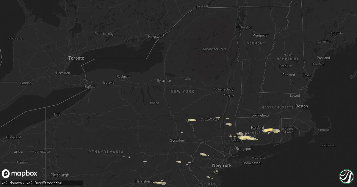
Hail Map in New York on June 30, 2024
Get this storm
June 30 map
$229
one time, instant access
Download today. No call, no setup
Keep the $229
Bought the map and want the full workflow? Apply the entire $229 to a subscription within 7 days. None of it is wasted.
Every map, not just this one
This buys you this map. Subscription and you get every map we run, in the markets you choose from a few cities to whole states to nationwide. Plus real-time alerts the moment a storm fires.
Contact data
Name, contact info, occupancy, even credit band for addresses in the footprint. You go from where it hit to who to call.
Become the source they trust
Unlimited branding weather history reports on demand. You already have the documented answer ready for the property owner, and you are the one who showed up with it.
Property data and RoofTrace estimates
Pull up any address you have got, its value and the exact code rules for that jurisdiction, straight from One Click Code. Then RoofTrace estimates the squares, pitch, and roof value, priced the way you price.
Storm reports in New York
New York
| Date | Description |
|---|---|
| 06/30/20244:38 PM CDT | Fdny reports wires down and tree on home on elmwood ave. Time estimate from radar. |
| 06/30/20244:00 PM CDT | Utility reports downed wires. Time estimated from radar. |
| 06/30/202412:30 PM CDT | Tree down on route 55 at route 22 ramp. Time estimated from radar. |
| 06/30/202412:13 PM CDT | Route 82 at lomala road is closed due to tree down on wires. |
| 06/30/202412:10 PM CDT | Tree uprooted and down on a house. Report from social media. Time estimated from radar. |
| 06/30/202412:09 PM CDT | Social media post of snapped tree near fishkill. |
| 06/30/202411:00 AM CDT | Tree & wires down across turkey hill rd. |
| 06/30/202410:54 AM CDT | Deck swing destroyed and dec |
| 06/30/202410:54 AM CDT | Deck swing destroyed and deck railing damaged and blown away. |
| 06/30/202410:49 AM CDT | Route 32 closed due to tree down at ulster landing rd. Time estimated from radar. |
| 06/30/202410:47 AM CDT | Tree down on sawdust ave. Time estimated from radar. |
| 06/30/202410:47 AM CDT | Trees and wires downed on a vehicle with entrapment on route 32. |
| 06/30/202410:47 AM CDT | Tree downed on wires on old stage road. |
| 06/30/202410:46 AM CDT | Tree down on lucas ave ext and hinel rd. Time estimated from radar. |
| 06/30/202410:45 AM CDT | Tree down on apartment building along route 209. Time estimated from radar. |
| 06/30/202410:45 AM CDT | Trees and wires downed on route 28. |
| 06/30/202410:43 AM CDT | Tree down on wires on osterhoudt ln. Time estimated by radar. |
| 06/30/202410:40 AM CDT | Wires down on upper frog hollow road. |
| 06/30/202410:40 AM CDT | Trees and wires downed on chestnut hill road. |
| 06/30/202410:40 AM CDT | Trees and wires downed on ryan drive. |
| 06/30/202410:33 AM CDT | Tree and wires down on crispell rd. Time estimated from radar. |
| 06/30/202410:20 AM CDT | Tree downed in mt temper. |
| 06/30/202410:19 AM CDT | Tree down on wires. Time estimated from radar. |
| 06/30/202410:14 AM CDT | Trees and wires downed on route 214. |
| 06/30/202410:14 AM CDT | Route 214 closed due to tree down at willa ln. Time estimated from radar. |
| 06/30/202410:05 AM CDT | Trees and wires down as per county dispatch feed. Radar estimated time. |
| 06/30/20249:52 AM CDT | Trees down on knickerbocker road as per county dispatch feed. Radar-estimated time. |
| 06/30/20249:43 AM CDT | Power poles downed. |
| 06/30/20249:41 AM CDT | Multiple trees down at russel brook campsites with multiple people trapped. Unknown how many injuries at this time. Time estimated from radar. |
| 06/30/20249:40 AM CDT | Multiple trees down at butternut grove campground as per county dispatch feed. Radar-estimated time. |
| 06/30/20249:39 AM CDT | Multiple trees down right off of old route 17 near baxter mountain road. Time estimated from radar. |
| 06/30/20249:39 AM CDT | Multiple trees down on cooks falls road. Time estimated from radar. |
| 06/30/20249:35 AM CDT | *** 1 fatal... 1 inj *** corrects previous tstm wnd dmg report from 1 nw cooks falls. Nws storm survey confirms microburst of 90 mph. Many rvs... Camper units... A few |
| 06/30/20249:31 AM CDT | Multiple trees down on charles medlar road. Time estimated from radar. |
| 06/30/20249:27 AM CDT | Multiple trees down just west of fishs eddy. Time estimated from radar. |
| 06/30/20249:16 AM CDT | Tree down on wires on pennsylvania avenue. Time estimated from radar. |
| 06/30/20249:16 AM CDT | Multiple trees down in the village of hancock. Time estimated from radar. |
All States Impacted by Hail Map on June 30, 2024
Cities Impacted by Hail Map on June 30, 2024
- Seney, MI
- McMillan, MI
- Newberry, MI
- Engadine, MI
- Scottsville, KY
- Holland, KY
- Hancock, NY
- East Branch, NY
- Fishs Eddy, NY
- Long Eddy, NY
- Roscoe, NY
- Parksville, NY
- Willow, NY
- Bearsville, NY
- Woodstock, NY
- Mount Tremper, NY
- Saugerties, NY
- Red Hook, NY
- McDaniels, KY
- Clinton Corners, NY
- Stanfordville, NY
- Salt Point, NY
- Hyde Park, NY
- Staatsburg, NY
- Millbrook, NY
- Leitchfield, KY
- New Milford, CT
- Washington Depot, CT
- Bellefonte, PA
- Howard, PA
- Washington, CT
- Roxbury, CT
- Sarasota, FL
- Rebersburg, PA
- Osprey, FL
- Carmel, NY
- Holmes, NY
- Stormville, NY
- West Point, VA
- Barhamsville, VA
- Patterson, NY
- Clinton, AR
- Center Ridge, AR
- Bridgewater, CT
- Brookfield, CT
- Pawling, NY
- Sherman, CT
- New Fairfield, CT
- Springfield, AR
- Selinsgrove, PA
- Woodbury, CT
- Southbury, CT
- Greenbrier, AR
- Bee Branch, AR
- Hattieville, AR
- Newtown, CT
- Sandy Hook, CT
- Hebron, CT
- Marlborough, CT
- Glastonbury, CT
- Arkadelphia, AR
- Jerusalem, AR
- Damascus, AR
- Amston, CT
- Sunbury, PA
- Middlebury, CT
- Oakville, CT
- Watertown, CT
- Waterbury, CT
- Bethlehem, CT
- Lebanon, CT
- Columbia, CT
- Naugatuck, CT
- Oxford, CT
- Aberdeen, NC
- West End, NC
- Wolcott, CT
- Willimantic, CT
- Andover, CT
- Coventry, CT
- Bethany, CT
- Beacon Falls, CT
- Prospect, CT
- Mansfield Center, CT
- Windham, CT
- Millinocket, ME
- Colchester, CT
- Cheshire, CT
- South Windham, CT
- North Windham, CT
- Hampton, CT
- Pickens, SC
- Pinehurst, NC
- Canterbury, CT
- Newton, NJ
- Castlewood, VA
- Saint Paul, VA
- Coeburn, VA
- Hamden, CT
- Wallingford, CT
- Baltic, CT
- Jewett City, CT
- Scotland, CT
- North Haven, CT
- Benton, AR
- Traskwood, AR
- Plainfield, CT
- Sparta, NJ
- Andover, NJ
- Moosup, CT
- Lafayette, NJ
- Manheim, PA
- Palmyra, PA
- Northford, CT
- Durham, CT
- Guilford, CT
- Easley, SC
- Lititz, PA
- Newfoundland, NJ
- Rockaway, NJ
- Palmerton, PA
- Walnutport, PA
- Lehighton, PA
- Lake Hopatcong, NJ
- Dungannon, VA
- Fort Blackmore, VA
- Mount Gretna, PA
- Lebanon, PA
- Bath, NH
- Wells River, VT
- Woodsville, NH
- Lisbon, NH
- Franconia, NH
- Lincoln, NH
- Stevens, PA
- Ephrata, PA
- Bangor, PA
- Pen Argyl, PA
- Nazareth, PA
- North Haverhill, NH
- Danielsville, PA
- Kunkletown, PA
- Newbury, VT
- Greer, SC
- Denver, PA
- Cordell, OK
- Woodruff, SC
- Simpsonville, SC
- Easton, PA
- Fountain Run, KY
- Carbondale, PA
- Booneville, AR
- Cape Charles, VA
- Lima, MT
- Colony, OK
- Warren, NH
- Oxford, ME
- Casco, ME
- Harrison, ME
- Poland, ME
- Cheyenne, WY
- Burnham, ME
- Unity, ME
- Parks, AR
- Harvey, AR
- Clinton, ME
- York, PA
- Lewisville, AR
- Hope, AR
- San Simon, AZ
- Troy, ME
- Wrightsville, PA
- Oden, AR
- Pencil Bluff, AR
- Chugwater, WY
- Laramie, WY
- Morganton, NC
- Clark, NJ
- Colonia, NJ
- Newmanstown, PA
- Chaparral, NM
- Gillette, WY
- Bird In Hand, PA
- Leola, PA
- Strasburg, PA
- Meriden, WY
- Lagrange, WY
- White Sands Missile Range, NM
- Sierra Blanca, TX
- Elfrida, AZ
- Robesonia, PA
- Coatesville, PA
- Cloudcroft, NM
- Staten Island, NY
- Perth Amboy, NJ
- Fords, NJ
- Keasbey, NJ
- Virginia City, MT
- West Chester, PA
- Kennett Square, PA
- Las Cruces, NM
- Guernsey, WY
- Hanover, MD
- Annapolis Junction, MD
- Jessup, MD
- Severn, MD
- Fort George G Meade, MD
- Wheatland, WY
- Hartville, WY
- Gambrills, MD
- Odenton, MD
- Millersville, MD
- Cameron, MT
- Folsom, PA
- Woodlyn, PA
- Wallingford, PA
- Swarthmore, PA
- Ronks, PA
- Thornton, PA
- Glen Mills, PA
- Oxford, NC
- North East, MD
- Annapolis, MD
- Severna Park, MD
- Crownsville, MD
- Arnold, MD
- Bozeman, MT
- Garnet Valley, PA
- Aston, PA
- Marcus Hook, PA
- Stem, NC
- Princeton, NJ
- Swedesboro, NJ
- Bridgeport, NJ
- Edgewater, MD
- Hillsborough, NJ
- Somerset, NJ
- Sewell, NJ
- Mantua, NJ
- Warwick, MD
- Earleville, MD
- Elgin, SC
- Clarksboro, NJ
- Mickleton, NJ
- Spotsylvania, VA
- Whitehouse Station, NJ
- Willcox, AZ
- Kendall Park, NJ
- Monroe Township, NJ
- Monmouth Junction, NJ
- Dayton, NJ
- Aiken, SC
- Woodford, VA
- Mathiston, MS
- Middletown, DE
- Livingston Manor, NY
- Old Bridge, NJ
- Livingston, MT
- Ruther Glen, VA
- Townsend, DE
- Castle Rock, CO
- Cranbury, NJ
- Forest City, PA
- Oak Ridge, NJ
- Bowie, MD
- Upper Marlboro, MD
- Lanham, MD
- Hyattsville, MD
- Dermott, AR
- Mount Laurel, NJ
- Maple Shade, NJ
- Cherry Hill, NJ
- Marlton, NJ
- Voorhees, NJ
- Medford, NJ
- Vincentown, NJ
- Franktown, CO
- Wilsall, MT
- Batesburg, SC
- Emigrant, MT
- Pray, MT
- Smyrna, DE
- Milford, VA
- Gallatin Gateway, MT
- Saint David, AZ
- Douglas, WY
- Barnegat, NJ
- Chatsworth, NJ
- Delhi, LA
- Media, PA
- Elbert, CO
- Rhinebeck, NY
- Nogales, AZ
- Patagonia, AZ
- West Creek, NJ
- Tuckerton, NJ
- Beach Haven, NJ
- Egg Harbor City, NJ
- Sicklerville, NJ
- Williamstown, NJ
- Clementon, NJ
- West Berlin, NJ
- Berlin, NJ
- Gibbsboro, NJ
- Atco, NJ
- Waterford Works, NJ
- Hammonton, NJ
- Stratford, NJ
- Mays Landing, NJ
- New Gretna, NJ
- Absecon, NJ
- Port Republic, NJ
- Brigantine, NJ
- Somerdale, NJ
- Manahawkin, NJ
- Newcastle, WY
- Larkspur, CO
- Rising Sun, MD
- Nottingham, PA
- Amenia, NY
- Davidsonville, MD
- Lothian, MD
- Springfield, PA
- Broomall, PA
- Baskin, LA
- Lance Creek, WY
- Wenonah, NJ
- Rayville, LA
- Mangham, LA
- Columbia, LA
- Ward, AL
- Buckhorn, NM
- Montpelier, VA
- Richland, GA
- Cusseta, GA
- Elkton, MD
- Colorado Springs, CO
- Chester, PA
- Brookhaven, PA
- Tracys Landing, MD
- Dunkirk, MD
- Deale, MD
- Glen Allen, VA
- Ashland, VA
- Lorton, VA
- Fort Belvoir, VA
- Butler, AL
- Pennington, AL
- Newport, NJ
- Rockville, VA
- North Beach, MD
- Lincoln University, PA
- West Grove, PA
- Landenberg, PA
- Jachin, AL
- Newark, DE
- Port Deposit, MD
- Elk Mills, MD
- Shawmut, MT
- Summerville, GA
- Doswell, VA
- Beaverdam, VA
- Winnsboro, LA
- Hockessin, DE
- Avondale, PA
- Waldorf, MD
- Bryans Road, MD
- Indian Head, MD
- Matheson, CO
- White Plains, MD
- La Plata, MD
- Pomfret, MD
- Chesapeake City, MD
- Edgemont, SD
- Custer, SD
- Limon, CO
- Brandywine, MD
- Hughesville, MD
- Bryantown, MD
- Harwood, MD
- Bonifay, FL
- Shoup, ID
- Greenwich, NJ
- Hanover, VA
- Denmark, SC
- Mechanicsville, VA
- Graceville, FL
- Chipley, FL
- Fredericksburg, VA
- Paonia, CO
- Charlotte Hall, MD
- Mechanicsville, MD
- Henrico, VA
- Hugo, CO
- Ramah, CO
- Glen Burnie, MD
- Pasadena, MD
- Gibson Island, MD
- Pagosa Springs, CO
- Boone, CO
- Alexandria, VA
- Hysham, MT
- Barnwell, SC
- Forsyth, MT
- Fe Warren Afb, WY
- Villa Grove, CO
- Custer, MT
- Rosebud, MT
- Allendale, SC
- Chestertown, MD
- Bighorn, MT
- Sanders, MT
- Lebanon, NJ
- Millen, GA
- Somerville, NJ
- Hathaway, MT
- Riva, MD
- Chadds Ford, PA
- Cedarville, NJ
- Centreville, MD
- Hillsdale, WY
- Carpenter, WY
- Burns, WY
- Kinsey, MT
- Sanford, NC
- Moncure, NC
- Pittsboro, NC
- Garfield, GA
- Kit Carson, CO
- Portal, GA
- Cohagen, MT
- Terry, MT
- Jordan, MT
- Karval, CO
- Circle, MT
- Brockway, MT
- Haswell, CO
- Lindsay, MT
- Chauncey, GA
- Eastman, GA
- Calhan, CO
- Simla, CO
- Agate, CO
- Cheyenne Wells, CO
- Genoa, CO
- Hill City, KS
- Rocky Ford, GA
- Rush, CO
- Zap, ND
- Beulah, ND
- Bogue, KS
- Hazen, ND
- Stanton, ND
- Lenora, KS
- Logan, KS
- Underwood, ND
- Coleharbor, ND
- Riverdale, ND


