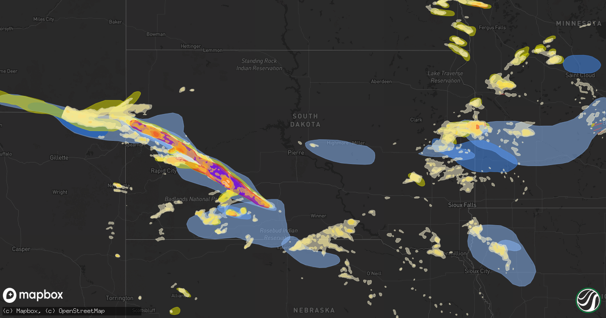
Hail Map in South Dakota on June 28, 2025
Get this storm
June 28 map
$229
one time, instant access
Download today. No call, no setup
Keep the $229
Bought the map and want the full workflow? Apply the entire $229 to a subscription within 7 days. None of it is wasted.
Every map, not just this one
This buys you this map. Subscription and you get every map we run, in the markets you choose from a few cities to whole states to nationwide. Plus real-time alerts the moment a storm fires.
Contact data
Name, contact info, occupancy, even credit band for addresses in the footprint. You go from where it hit to who to call.
Become the source they trust
Unlimited branding weather history reports on demand. You already have the documented answer ready for the property owner, and you are the one who showed up with it.
Property data and RoofTrace estimates
Pull up any address you have got, its value and the exact code rules for that jurisdiction, straight from One Click Code. Then RoofTrace estimates the squares, pitch, and roof value, priced the way you price.
Storm reports in South Dakota
South Dakota
| Date | Description |
|---|---|
| 06/28/20256:59 PM CDT | Relayed from multiple spotters. |
| 06/28/20256:47 PM CDT | A local report indicates 1.00 inch wind near 14 E Ellsworth AFB |
| 06/28/20256:45 PM CDT | A local report indicates 59 MPH wind near 3 NW Wasta |
| 06/28/20256:20 PM CDT | A local report indicates 1.25 inch wind near 7 NNE Ellsworth AFB |
| 06/28/20256:20 PM CDT | A local report indicates 65 MPH wind near 2 E Elm Springs |
| 06/28/20256:05 PM CDT | A local report indicates 66 MPH wind near 11 SSE Hereford |
| 06/28/20256:00 PM CDT | A local report indicates 60 MPH wind near 14 E Ellsworth AFB |
| 06/28/20255:55 PM CDT | A local report indicates 1.50 inch wind near 4 N Dwtn Rapid City |
| 06/28/20255:55 PM CDT | A local report indicates 1.50 inch wind near 7 NNE Ellsworth AFB |
| 06/28/20255:42 PM CDT | A local report indicates 2.50 inch wind near 1 N Hereford |
| 06/28/20255:42 PM CDT | A local report indicates 80 MPH wind near 1 N Hereford |
| 06/28/20255:35 PM CDT | A local report indicates 1.75 inch wind near 6 NNW Hereford |
| 06/28/20255:00 PM CDT | A local report indicates 80 MPH wind near Vale |
| 06/28/20255:00 PM CDT | A local report indicates 2.50 inch wind near Vale |
| 06/28/20254:50 PM CDT | A local report indicates 85 MPH wind near 1 NNW Nisland |
| 06/28/20254:45 PM CDT | A local report indicates 74 MPH wind near 1 NNW Nisland |
| 06/28/20254:42 PM CDT | A local report indicates 1.75 inch wind near 2 W Nisland |
| 06/28/20254:42 PM CDT | A local report indicates 80 MPH wind near 2 W Nisland |
| 06/28/20254:35 PM CDT | Winds to at least 60 mph. Windows broken in the house and camper. |
| 06/28/20254:15 PM CDT | A local report indicates 1.00 inch wind near 14 N Belle Fourche |
| 06/28/20254:15 PM CDT | Winds also to 60 mph. |
| 06/28/20254:01 PM CDT | A local report indicates 59 MPH wind near 13 NW Belle Fourche |
| 06/28/20257:45 AM CDT | Awos station kbkx brookings municipal airport. |
| 06/28/20257:41 AM CDT | Mesonet station vgas2 volga |
| 06/28/20257:40 AM CDT | Measured by personal weather station. |
| 06/28/20257:16 AM CDT | Tree damage and around 1 mile of power poles downed by thunderstorm winds. |
| 06/28/20256:06 AM CDT | Personal weather station peak gust. |
| 06/28/20256:04 AM CDT | Mesonet station 289 lee |
| 06/28/20256:04 AM CDT | Mesonet station 289 lees corner |
| 06/28/20255:53 AM CDT | Mesonet station 201 gann valley |
| 06/28/20255:49 AM CDT | Mesonet station 312 ree heights |
| 06/28/20255:48 AM CDT | Mesonet station 183 ma |
| 06/28/20255:48 AM CDT | Mesonet station 183 macs corner |
| 06/28/20255:37 AM CDT | Mesonet station 183 macs corner |
| 06/28/20255:30 AM CDT | Mesonet station hihs2 highmore |
| 06/28/20255:14 AM CDT | Davis weather station in holabird. |
| 06/28/20255:09 AM CDT | Mesonet station 19 harrold |
| 06/28/20251:16 AM CDT | A local report indicates 58 MPH wind near 15 SSE Mission |
| 06/28/20251:10 AM CDT | A local report indicates 65 MPH wind near 1 S White River |
| 06/28/202512:50 AM CDT | A local report indicates 71 MPH wind near 11 SW Parmelee |
| 06/28/202512:45 AM CDT | Time estimated from radar |
| 06/28/202512:45 AM CDT | A local report indicates 73 MPH wind near 3 NNE Harrington |
| 06/28/202512:40 AM CDT | A local report indicates 68 MPH wind near 11 SW Parmelee |
| 06/28/202512:35 AM CDT | A local report indicates 61 MPH wind near 13 NW Belle Fourche |
| 06/28/202512:32 AM CDT | Mesonet station 224 sd rwis ward. |
| 06/28/202512:10 AM CDT | A local report indicates 58 MPH wind near 4 ENE Martin |
| 06/28/202512:05 AM CDT | A local report indicates 60 MPH wind near 1 ESE Martin |
| 06/28/202512:03 AM CDT | Awos station kbkx brookings municipal airport. |
| 06/27/202511:48 PM CDT | Mesonet station vgas2 volga |
| 06/27/202511:41 PM CDT | A local report indicates 67 MPH wind near 5 NE Porcupine |
| 06/27/202511:06 PM CDT | Hail was briefly nickel to quarter size. |
| 06/27/202510:54 PM CDT | Trained spotter had quarter plus sized hail 1 mile east of lake poinsett. |
| 06/27/202510:18 PM CDT | State radio report of a different tornado 1 mile north of toronto. |
| 06/27/202510:16 PM CDT | State radio report of tornado 1 mile east of toronto. |
| 06/27/20259:50 PM CDT | A local report indicates 1.00 inch wind near 2 S Thomas |
| 06/27/20259:40 PM CDT | A local report indicates 1.00 inch wind near 4 W Castlewood |
| 06/27/20259:20 PM CDT | A local report indicates 58 MPH wind near 15 SSE Mission |
| 06/27/20258:58 PM CDT | Report from mping: hen egg |
| 06/27/20258:47 PM CDT | Tornado in gary took out a house. |
| 06/27/20258:40 PM CDT | Estimated 60 to 70 mph |
| 06/27/20258:30 PM CDT | Tornado reported around the lake cochrane rec area. |
| 06/27/20258:24 PM CDT | A local report indicates 60 MPH wind near 5 SE Norris |
| 06/27/20258:13 PM CDT | Spotter called with a tornado on the ground. |
| 06/27/20257:50 PM CDT | A local report indicates 1.00 inch wind near 1 NW Kadoka |
| 06/27/20257:45 PM CDT | A local report indicates 73 MPH wind near 4 E Cactus Flat |
| 06/27/20257:35 PM CDT | A local report indicates 85 MPH wind near 4 E Cactus Flat |
| 06/27/20257:30 PM CDT | A local report indicates 78 MPH wind near 4 E Cactus Flat |
| 06/27/20257:25 PM CDT | A local report indicates 67 MPH wind near 4 E Cactus Flat |
| 06/27/20257:25 PM CDT | Took out jackson co. Deputy sheriff's windshield on i-90 |
| 06/27/20257:21 PM CDT | A local report indicates 68 MPH wind near 6 W Cottonwood |
| 06/27/20257:11 PM CDT | A local report indicates 60 MPH wind near 6 W Cottonwood |
| 06/27/20257:07 PM CDT | Trees blown down and abandoned structure was damaged/hit. |
All States Impacted by Hail Map on June 28, 2025
Cities Impacted by Hail Map on June 28, 2025
- Erwin, SD
- De Smet, SD
- Hitchcock, SD
- Arlington, SD
- Lake Preston, SD
- Huron, SD
- Lake Norden, SD
- Badger, SD
- Worthington, MN
- Volga, SD
- Bruce, SD
- Brookings, SD
- Aurora, SD
- White, SD
- Elkton, SD
- Hartland, MN
- Albert Lea, MN
- Alden, MN
- Walnut Grove, MN
- Kevil, KY
- Metropolis, IL
- West Paducah, KY
- Paducah, KY
- Buchanan, TN
- Murray, KY
- Saint Louisville, OH
- Newark, OH
- Lebanon, TN
- Mount Solon, VA
- Lithia, FL
- Durham, NC
- Pittsboro, NC
- Stanton, TN
- Somerville, TN
- Corydon, IN
- Kensal, ND
- Chambersburg, PA
- Bradenton, FL
- Salisbury, NC
- Asheville, NC
- Auburndale, FL
- Waterville, PA
- Glenfield, ND
- Jersey Shore, PA
- Granville, OH
- Lexington, NC
- Winter Haven, FL
- Chapel Hill, TN
- Eagleville, TN
- Madison, FL
- Cogan Station, PA
- Grace City, ND
- Lock Haven, PA
- Brownsville, TN
- Linden, PA
- Williamsport, PA
- Lake Alfred, FL
- Mchenry, ND
- Berryville, VA
- Campbellsville, KY
- Myakka City, FL
- Jacksonville, FL
- Montoursville, PA
- Hulett, WY
- Henderson, NC
- Kittrell, NC
- Tolna, ND
- New Rockford, ND
- Pekin, ND
- Mocksville, NC
- Jacksonville Beach, FL
- Alzada, MT
- Belle Fourche, SD
- Vero Beach, FL
- Saint Cloud, FL
- Fort Pierce, FL
- Ripley, TN
- Summertown, TN
- Kimbolton, OH
- Kenansville, FL
- Okeechobee, FL
- Culleoka, TN
- Lakota, ND
- Michigan, ND
- Buffalo, SD
- Sutton, ND
- Tatum, NM
- Courtenay, ND
- Cleveland, GA
- Sautee Nacoochee, GA
- Clarkesville, GA
- Binford, ND
- Petersburg, ND
- Cambridge, OH
- Avon Park, FL
- Corinth, MS
- Nisland, SD
- Newell, SD
- Newcomerstown, OH
- Demorest, GA
- Martinsburg, WV
- Falling Waters, WV
- Williamsport, MD
- Page, ND
- Erie, ND
- Pembina, ND
- Saint Vincent, MN
- Hallock, MN
- Lancaster, MN
- Vale, SD
- Whitewood, SD
- Cooperstown, ND
- Wimbledon, ND
- Hannaford, ND
- Warwick, ND
- Hagerstown, MD
- Boonsboro, MD
- Union Springs, AL
- Shepherdstown, WV
- Fairfield, OH
- Hamilton, OH
- West Chester, OH
- Middletown, OH
- Venus, FL
- Rogers, ND
- Sebring, FL
- Punta Gorda, FL
- North Fort Myers, FL
- Arcadia, FL
- Lorida, FL
- Hunter, ND
- Arthur, ND
- Elizabeth, PA
- Monongahela, PA
- Clairton, PA
- Millersport, OH
- Gardner, ND
- Sanborn, ND
- Valley City, ND
- Sturgis, SD
- Union Center, SD
- Deer Lodge, TN
- Allardt, TN
- Manila, AR
- Webster, PA
- Belle Vernon, PA
- Lovington, NM
- Leachville, AR
- Troy, AL
- Mcdonald, NM
- Lake Placid, FL
- Labelle, FL
- Cincinnati, OH
- Moore Haven, FL
- New Underwood, SD
- Jamestown, TN
- Lake Bronson, MN
- Argusville, ND
- Enning, SD
- Box Elder, SD
- Sidney, NE
- Peetz, CO
- Crook, CO
- Lodgepole, NE
- Augusta, WV
- Romney, WV
- Sunbright, TN
- Robbins, TN
- Wasta, SD
- Howes, SD
- Piedmont, SD
- Blairsville, GA
- Healy, KS
- Felda, FL
- Immokalee, FL
- Caputa, SD
- Owanka, SD
- Manchester, OH
- Aberdeen, OH
- Castlewood, SD
- Galax, VA
- Fries, VA
- Morrow, OH
- Maineville, OH
- Junction City, OH
- New Straitsville, OH
- Rugby, TN
- Stoutsville, OH
- Circleville, OH
- Laurelville, OH
- Amanda, OH
- Tarlton, OH
- Lititz, PA
- Newmanstown, PA
- Monroe, OH
- South Lebanon, OH
- Mason, OH
- Blanchester, OH
- Pleasant Plain, OH
- Kings Mills, OH
- Badger, MN
- Greenbush, MN
- Leonard, ND
- Davenport, ND
- Kindred, ND
- Milbank, SD
- Big Stone City, SD
- Odessa, MN
- Bellingham, MN
- Marietta, MN
- Watertown, SD
- Goodwin, SD
- Clear Lake, SD
- Wall, SD
- Appleton, MN
- Hebron, OH
- Gunnison, MS
- Bloomery, WV
- Capon Bridge, WV
- Rapid City, SD
- Scenic, SD
- Hancock, MN
- Danvers, MN
- Lancaster, OH
- Hillsville, VA
- Austinville, VA
- Union, SC
- Horace, ND
- Willis, VA
- Decatur, AR
- Gravette, AR
- Buffalo, ND
- Hobbs, NM
- Labolt, SD
- Revillo, SD
- Wheatland, ND
- Mapleton, ND
- Quinn, SD
- Hope, IN
- Flat Rock, IN
- Walcott, ND
- Benson, MN
- Clontarf, MN
- Gary, SD
- Big Springs, NE
- Brule, NE
- Waynesville, OH
- Thornville, OH
- Pleasantville, OH
- Lebanon, OH
- Franklin, OH
- Clarksville, OH
- Bella Vista, AR
- Bentonville, AR
- Kadoka, SD
- Philip, SD
- Fairplay, MD
- Goshen, OH
- Loveland, OH
- Interior, SD
- Wanblee, SD
- Alliance, NE
- Ellsworth, NE
- Yuma, CO
- Haxtun, CO
- Holyoke, CO
- Wray, CO
- Amherst, CO
- Comstock, MN
- Moorhead, MN
- Holloway, MN
- Centerton, AR
- De Witt, AR
- Pryor, MT
- Lodge Grass, MT
- Bremen, OH
- Dacula, GA
- Buford, GA
- Madison, MN
- Sheridan Lake, CO
- Sabin, MN
- Rushville, OH
- Seminole, TX
- Barnesville, MN
- Inwood, WV
- Kearneysville, WV
- Hedgesville, WV
- Farwell, MN
- Morris, MN
- Fort Stockton, TX
- Wolverton, MN
- Rothsay, MN
- Pelican Rapids, MN
- Sheldon, ND
- Wyndmere, ND
- Mcleod, ND
- Alexandria, MN
- Garfield, MN
- Kensington, MN
- Carlos, MN
- Osakis, MN
- Long Prairie, MN
- Eagle Bend, MN
- Chokio, MN
- Alberta, MN
- Mooreton, ND
- Wahpeton, ND
- Colfax, ND
- Leoti, KS
- Cyrus, MN
- Winchester, OH
- Seaman, OH
- Lowry, MN
- Long Valley, SD
- Breckenridge, MN
- Campbell, MN
- Hankinson, ND
- Mantador, ND
- Nelson, MN
- Washington Boro, PA
- Conestoga, PA
- Peebles, OH
- Millersville, PA
- Stevens, PA
- Lebanon, PA
- Ephrata, PA
- Columbia, PA
- Mount Joy, PA
- Marietta, PA
- Lancaster, PA
- East Petersburg, PA
- Manheim, PA
- West Union, OH
- Angora, NE
- Bridgeport, NE
- Belvidere, SD
- White River, SD
- Norris, SD
- Saint Xavier, MT
- Garryowen, MT
- Fairmount, ND
- Strandburg, SD
- Canby, MN
- Julesburg, CO
- Salem, VA
- Points, WV
- Grey Eagle, MN
- Burtrum, MN
- Allen, SD
- Swanville, MN
- Marienthal, KS
- Barney, ND
- Kent, MN
- Logan, OH
- Sugar Grove, OH
- Pequea, PA
- Willow Street, PA
- Starbuck, MN
- Lidgerwood, ND
- Martin, SD
- Busby, MT
- Decker, MT
- Birney, MT
- Porcupine, SD
- Batesland, SD
- Clinton, SC
- Grantsville, WV
- Rosholt, SD
- New Effington, SD
- Sauk Centre, MN
- Melrose, MN
- Freeport, MN
- Correll, MN
- Laurens, SC
- Hazel, SD
- Sundance, WY
- Hill City, SD
- Hermosa, SD
- Recluse, WY
- Moorcroft, WY
- Weston, WY
- Lead, SD
- Gillette, WY
- Otter, MT
- Hayti, SD
- Boyd, MN
- Minneota, MN
- Porter, MN
- Taunton, MN
- Brandt, SD
- Estelline, SD
- Browerville, MN
- Brasstown, NC
- Greensburg, KY
- Clarissa, MN
- Deerfield, KS
- Holcomb, KS
- Garden City, KS
- Upsala, MN
- Johnson, KS
- Ware Shoals, SC
- Holdingford, MN
- Bowlus, MN
- Albany, MN
- Cushing, MN
- Astoria, SD
- Wheaton, MN
- Broadus, MT
- Glenwood, MN
- Villard, MN
- Charleston, MS
- Rosedale, MS
- Murdock, MN
- Avon, MN
- Royalton, MN
- Foley, MN
- Pierz, MN
- Saint Joseph, MN
- Rice, MN
- Saint Stephen, MN
- Sartell, MN
- Saint Cloud, MN
- Sauk Rapids, MN
- Foreston, MN
- Hillman, MN
- Oak Park, MN
- Toronto, SD
- Clarkfield, MN
- Granite Falls, MN
- Sacred Heart, MN
- Dawson, MN
- Hanley Falls, MN
- Wood Lake, MN
- Ivanhoe, MN
- Cottonwood, MN
- Hendricks, MN
- Sublette, KS
- Pierceville, KS
- Lakin, KS
- Hot Springs, SD
- Burton, WV
- Kyle, SD
- Bryant, SD
- Colome, SD
- Mount Zion, WV
- Springview, NE
- Winner, SD
- Valentine, NE
- Sparks, NE
- Buffalo Gap, SD
- Mission, SD
- Harrison, NE
- Minter City, MS
- Olive Hill, KY
- Dallas, SD
- Renville, MN
- Marshall, MN
- Echo, MN
- Ghent, MN
- Belview, MN
- Arco, MN
- Danube, MN
- Olivia, MN
- Lynd, MN
- Johnstown, NE
- Wood Lake, NE
- Copeland, KS
- Ingalls, KS
- Gregory, SD
- Burke, SD
- Ulysses, KS
- Jacksonburg, WV
- Smithfield, WV
- Montezuma, KS
- Cedar Bluff, VA
- Willow Lake, SD
- Kendall, KS
- Richfield, KS
- Willmar, MN
- Bandy, VA
- Mills, NE
- Pine Ridge, SD
- North Tazewell, VA
- Iroquois, SD
- Platte, SD
- Ainsworth, NE
- Long Pine, NE
- Plains, KS
- Devils Tower, WY
- Howard Lake, MN
- Brainerd, MN
- Oldham, SD
- Maple Lake, MN
- Annandale, MN
- Kimball, MN
- Monticello, MN
- Clearwater, MN
- South Haven, MN
- Clear Lake, MN
- Harrison, SD
- Corsica, SD
- Cold Spring, MN
- Buffalo, MN
- Hector, MN
- Bird Island, MN
- Brownton, MN
- Stewart, MN
- Buffalo Lake, MN
- Redwood Falls, MN
- Morton, MN
- Hutchinson, MN
- Vesta, MN
- Glencoe, MN
- Balaton, MN
- Seaforth, MN
- Russell, MN
- Milroy, MN
- Fairfax, MN
- Lucan, MN
- Tracy, MN
- Wabasso, MN
- Garvin, MN
- Franklin, MN
- Big Lake, MN
- Hemingford, NE
- Silver Lake, MN
- Winsted, MN
- Deerwood, MN
- Moscow, KS
- Cokato, MN
- Waverly, MN
- Ramona, SD
- Howard, SD
- Bassett, NE
- Saint Michael, MN
- Winfred, SD
- Young America, MN
- Cologne, MN
- Green Isle, MN
- Arlington, MN
- Norwood Young America, MN
- Morgan, MN
- Plato, MN
- New Auburn, MN
- Hamburg, MN
- Waconia, MN
- Winthrop, MN
- Lester Prairie, MN
- Chaska, MN
- Gaylord, MN
- Gibbon, MN
- Clements, MN
- Carver, MN
- New Germany, MN
- Maple Plain, MN
- Mound, MN
- Delano, MN
- Victoria, MN
- Watertown, MN
- Montrose, MN
- Excelsior, MN
- Saint Bonifacius, MN
- Mayer, MN
- Chanhassen, MN
- Hanover, MN
- Rockford, MN
- Hamel, MN
- Loretto, MN
- Wayzata, MN
- Long Lake, MN
- Rogers, MN
- Spring Park, MN
- Lusk, WY
- Herrick, SD
- Minneapolis, MN
- Osseo, MN
- Dayton, MN
- Eden Prairie, MN
- Minnetonka, MN
- Maple Grove, MN
- Alexandria, SD
- Alva, WY
- Belle Plaine, MN
- Lamberton, MN
- Hopkins, MN
- Henderson, MN
- Shakopee, MN
- Sleepy Eye, MN
- Sanborn, MN
- New Ulm, MN
- Springfield, MN
- Le Sueur, MN
- Wanda, MN
- Saint Peter, MN
- Lafayette, MN
- Comfrey, MN
- Courtland, MN
- Revere, MN
- Hanska, MN
- Nicollet, MN
- Lake Benton, MN
- Ruthton, MN
- Pipestone, MN
- Flandreau, SD
- Aladdin, WY
- Manderson, SD
- Tuthill, SD
- Wounded Knee, SD
- Sturgeon Lake, MN
- Saint Charles, SD
- Madison, SD
- Nunda, SD
- Merriman, NE
- Newport, NE
- Stuart, NE
- Bonesteel, SD
- Savage, MN
- Holland, MN
- Tyler, MN
- Woodstock, MN
- Rutland, SD
- Fedora, SD
- Jordan, MN
- Gordon, WI
- Solon Springs, WI
- Beulah, WY
- Saint Francis, SD
- Cody, NE
- Spearfish, SD
- Saint Onge, SD
- Artesian, SD
- Canova, SD
- Parmelee, SD
- Kilgore, NE
- Lake Wilson, MN
- Currie, MN
- Slayton, MN
- Springbrook, WI
- Carthage, SD
- Minong, WI
- Reva, SD
- Prairie City, SD
- Wentworth, SD
- Colman, SD
- Naper, NE
- Spencer, SD
- Crookston, NE
- Nenzel, NE
- Tripp, SD
- Avon, SD
- Bison, SD
- Wagner, SD
- Avoca, MN
- Satanta, KS
- Atkinson, NE
- Hayward, WI
- Prior Lake, MN
- Edgemont, SD
- Dante, SD
- Saint Paul, MN
- Lake Elmo, MN
- Stillwater, MN
- Afton, MN
- South Saint Paul, MN
- Hudson, WI
- Saint Paul Park, MN
- Houlton, WI
- Bayport, MN
- Hastings, MN
- Cottage Grove, MN
- Inver Grove Heights, MN
- Newport, MN
- Burnsville, MN
- River Falls, WI
- Lakeland, MN
- Mendota, MN
- Circle Pines, MN
- Hugo, MN
- Marine On Saint Croix, MN
- Willernie, MN
- Somerset, WI
- Roberts, WI
- New Richmond, WI
- Rosebud, SD
- Mud Butte, SD
- Fulda, MN
- Egan, SD
- Trent, SD
- Heron Lake, MN
- Westbrook, MN
- Lesterville, SD
- Niobrara, NE
- Center, NE
- Winter, WI
- Utica, SD
- Oral, SD
- Menno, SD
- Scotland, SD
- Springfield, SD
- Verdigre, NE
- Brewster, MN
- Delmont, SD
- Chambers, NE
- Lance Creek, WY
- Mission Hill, SD
- Volin, SD
- Bloomfield, NE
- Gilman, WI
- Fairburn, SD
- Ewing, NE
- Oelrichs, SD
- Crofton, NE
- Winnetoon, NE
- Yankton, SD
- Irene, SD
- Sheldon, WI
- Dell Rapids, SD
- Edgerton, MN
- Kennan, WI
- Catawba, WI
- Medford, WI
- Withee, WI
- Chadron, NE
- Fordyce, NE
- Saint Helena, NE
- Osage City, KS
- Gayville, SD
- Wausa, NE
- Amelia, NE
- Whitney, NE
- Westboro, WI
- Prentice, WI
- Decker, IN
- Vincennes, IN
- Baltic, SD
- Bartlett, NE
- Jasper, MN
- Hartington, NE
- Wynot, NE
- Phillips, WI
- Brantwood, WI
- Garretson, SD
- Beresford, SD
- Plainview, NE
- Neligh, NE
- Ogema, WI
- Dover, DE
- Lebo, KS
- Hammond, WI
- Baldwin, WI
- Inwood, IA
- Petersburg, NE
- Canton, SD
- Vermillion, SD
- Rib Lake, WI
- Camden Wyoming, DE
- Alcester, SD
- Hudson, SD
- Melvern, KS
- Fairview, SD
- Rock Valley, IA
- Merrill, WI
- Tripoli, WI
- Letcher, SD
- Plankinton, SD
- Lublin, WI
- Irma, WI
- Tomahawk, WI
- Stickney, SD
- Mount Vernon, SD
- Albion, NE
- Athens, WI
- Waverly, KS
- Hawarden, IA
- Pierce, NE
- Fort Meade, SD
- Lyndon, KS
- Garnett, KS
- Richmond, KS
- Norfolk, NE
- Brokaw, WI
- Wausau, WI
- Greeley, KS
- Marathon, WI
- Maurice, IA
- Orange City, IA
- Sioux Center, IA
- Stanton, NE
- Ireton, IA
- Independence, WI
- Le Mars, IA
- Atchison, KS
- Alton, IA
- Remsen, IA
- Oyens, IA
- Marcus, IA
- Granville, IA
- Oskaloosa, KS
- Ozawkie, KS
- Dodge, NE
- Howells, NE
- Nortonville, KS
- Pierre, SD
- Valley Falls, KS
- Deerbrook, WI
- Clarkson, NE
- Bryant, WI
- Macy, NE
- Parker, KS
- Lane, KS
- Wisner, NE
- Pilger, NE
- Leavenworth, KS
- Kingsley, IA
- Pierson, IA
- Tutwiler, MS
- Bridgewater, SD
- Columbus, NE
- Schuyler, NE
- West Point, NE
- Washta, IA
- Correctionville, IA
- Cleghorn, IA
- Quimby, IA
- Cherokee, IA
- Oakland, NE
- Blunt, SD
- Bellwood, NE
- McLouth, KS
- Lansing, KS
- Meriden, KS
- Easton, KS
- Winchester, KS
- Holstein, IA
- Scribner, NE
- Humboldt, NE
- Dawson, NE
- Kansas City, MO
- Platte City, MO
- Bruno, NE
- Linwood, NE
- David City, NE
- Blair, NE
- Fort Calhoun, NE
- Arlington, NE
- Mead, NE
- Yutan, NE
- Fremont, NE
- Bennington, NE
- Washington, NE
- Nickerson, NE
- Missouri Valley, IA
- Valley, NE
- Kennard, NE
- Crescent, IA
- Honey Creek, IA
- Omaha, NE
- Elkhorn, NE
- Council Bluffs, IA
- Neola, IA
- Waterloo, NE
- Underwood, IA
- Boys Town, NE
- Papillion, NE
- Gretna, NE
- Ashland, NE
- La Vista, NE
- McClelland, IA
- Carter Lake, IA
- Springfield, NE
- Ithaca, NE
- Verdon, NE
- Rock, MI
- Tonganoxie, KS
- Colon, NE
- Sturgeon Bay, WI
- Prague, NE
- Bark River, MI
- Escanaba, MI
- Bellevue, NE
- Hull, IA
- Sheldon, IA
- Boyden, IA
- Archer, IA
- Paullina, IA
- Primghar, IA
- Hartley, IA
- Sanborn, IA
- Sutherland, IA
- Hospers, IA
- Calumet, IA
- Meriden, IA
- Galva, IA
- Storm Lake, IA
- Peterson, IA
- Early, IA
- Larrabee, IA
- Aurelia, IA
- Schaller, IA
- Nemaha, IA
- Alta, IA
- Moville, IA
- Cushing, IA
- Akron, IA
- Lawton, IA
- Hinton, IA
- Chatsworth, IA
- Merrill, IA
- Brunsville, IA
- Westfield, IA
- Elk Point, SD
- Harrold, SD
- Highmore, SD
- Holabird, SD
- Onida, SD
- Stephan, SD
- Ree Heights, SD
- Miller, SD
- Independence, MO
- Dwight, NE
- Cornell, MI
- Valparaiso, NE
- Sabetha, KS
- Brussels, WI
- Salem, NE
- Falls City, NE
- Wahoo, NE
- Ceresco, NE
- Marinette, WI
- Abie, NE
- Weston, NE
- Forestville, WI
- Gann Valley, SD
- Wessington, SD
- Saint Lawrence, SD
- Wessington Springs, SD
- Danbury, IA
- Kiron, IA
- Battle Creek, IA
- Arthur, IA
- Anthon, IA
- Odebolt, IA
- Ida Grove, IA
- Pacific Junction, IA
- Offutt Afb, NE
- Plattsmouth, NE
- Murray, NE
- Louisville, NE
- Cedar Creek, NE
- Weeping Water, NE
- Nehawka, NE
- Glenwood, IA
- Newcastle, WY
- Talmage, NE
- Baileys Harbor, WI
- Fish Creek, WI
- Stella, NE
- Spearville, KS
- Seneca, KS
- Robinson, KS
- Highland, KS
- Baileyville, KS
- Egg Harbor, WI
- Basehor, KS
- Algoma, WI
- Wolsey, SD
- Virgil, SD
- Auburn, NE
- Nebraska City, NE
- Bern, KS
- Custer, SD
- Troy, KS
- Brock, NE
- Mountville, PA


