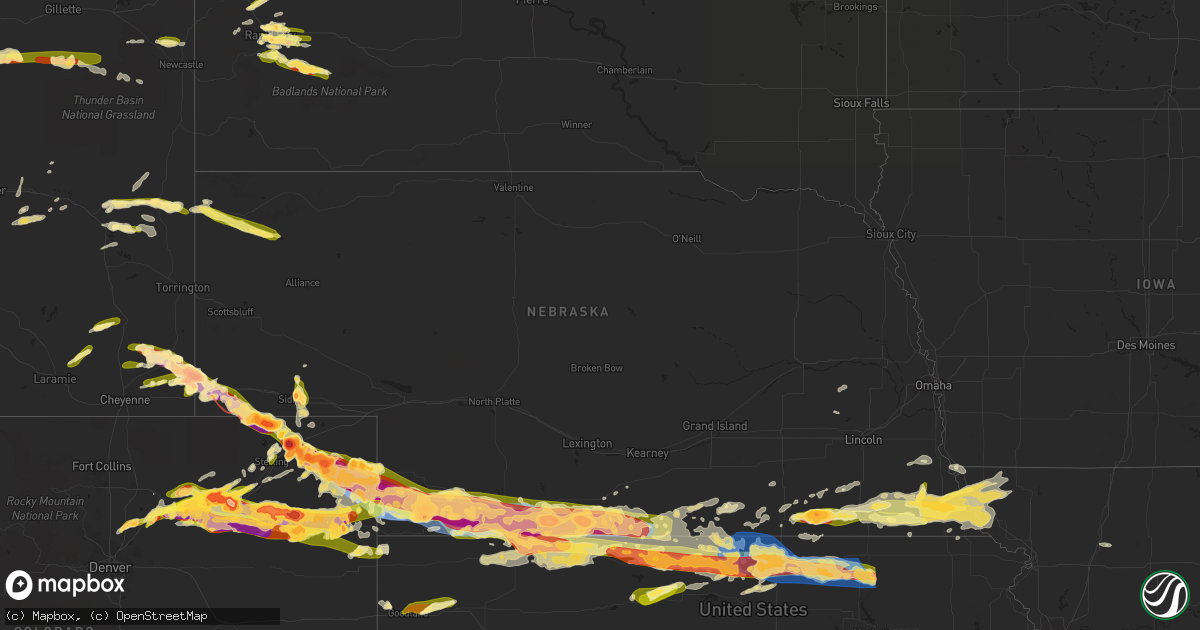
Hail Map in Nebraska on June 28, 2023
Get this storm
June 28 map
$229
one time, instant access
Download today. No call, no setup
Keep the $229
Bought the map and want the full workflow? Apply the entire $229 to a subscription within 7 days. None of it is wasted.
Every map, not just this one
This buys you this map. Subscription and you get every map we run, in the markets you choose from a few cities to whole states to nationwide. Plus real-time alerts the moment a storm fires.
Contact data
Name, contact info, occupancy, even credit band for addresses in the footprint. You go from where it hit to who to call.
Become the source they trust
Unlimited branding weather history reports on demand. You already have the documented answer ready for the property owner, and you are the one who showed up with it.
Property data and RoofTrace estimates
Pull up any address you have got, its value and the exact code rules for that jurisdiction, straight from One Click Code. Then RoofTrace estimates the squares, pitch, and roof value, priced the way you price.
Storm reports in Nebraska
Nebraska
| Date | Description |
|---|---|
| 06/28/20235:46 PM CDT | Quarter sized hail reported in harrison... Ne. |
| 06/28/202312:55 PM CDT | Corrects previous hail report from 6 sw champion from mdt to cdt. Public reports hail a little less than golf ball sized... Crop damage... Time estimated by radar. |
| 06/28/202312:50 PM CDT | Corrects previous hail report from 6 ssw champion from mdt to cdt. Public reports extended period of hail... Quarter sized and smaller... Stripped corn and crop. |
| 06/28/20236:58 AM CDT | Report from mping: 1-inch tree limbs broken; shingles blown off. |
| 06/28/20236:32 AM CDT | A personal weather station measured a peak wind gust of 59 mph. |
| 06/28/20235:25 AM CDT | Large tree uprooted. |
| 06/28/20234:58 AM CDT | A local report indicates 2.50 inch wind near 1 WNW Fairbury |
| 06/28/20234:57 AM CDT | A local report indicates 1.00 inch wind near 1 NW Fairbury |
| 06/28/20234:55 AM CDT | A local report indicates 2.00 inch wind near 1 NNW Fairbury |
| 06/28/20234:01 AM CDT | Delayed report from facebook. Time estimated. |
| 06/28/20234:00 AM CDT | Mesonet pws-kneorlea4. |
| 06/28/20233:58 AM CDT | Received photos via social media of trees down in alma. Wind estimated to 60+ mph. |
| 06/28/20233:58 AM CDT | Numerous large tree limbs down around town with several fully grown trees blown over. Significant damage to a few out buildings. Likely strong straight line wind damage |
| 06/28/20233:55 AM CDT | Observer reports broken windows from a combination of hail up to ping pong ball size and winds estimated around 70 mph. |
| 06/28/20233:55 AM CDT | Observer reports broken windows from a combination of hail up to ping pong ball size and winds estimated around 70 mph. |
| 06/28/20233:50 AM CDT | Mesonet wl-orleans1.5wnw. |
| 06/28/20233:41 AM CDT | Delayed report from facebook. All west facing windows of home broken... Including a panel of a sliding glass door. Time estimated. |
| 06/28/20233:27 AM CDT | Also broke 4 to 6 diameter tree limbs. |
| 06/28/20233:25 AM CDT | Facebook report and photo showing extensive home siding damage from a combination of hail up to baseball size and strong winds. Also reports of several broken car windo |
| 06/28/20233:25 AM CDT | Facebook report and photo showing extensive home siding damage from a combination of hail up to baseball size and strong winds. Also reports of several broken car windo |
| 06/28/20233:20 AM CDT | Furnas county deputies reported significant thunderstorm damage... Including multiple windows broken... Trees down... And tree damage... Due to both large hail and seve |
| 06/28/20233:10 AM CDT | Wind driven golf ball sized hail broke 7 windows on our observers house. Many other windows were broken around town. |
| 06/28/20233:10 AM CDT | Social media report of large hail that broke windows on the west side of a home. |
| 06/28/20233:05 AM CDT | Numerous windows broken... Tree limbs snapped. |
| 06/28/20233:00 AM CDT | Corrects previous tstm wnd gst report from 1 e cambridge. Estimated wind gusts of 60 to 70 mph. Also broke 4 to 6 inch diameter tree limbs. |
| 06/28/20233:00 AM CDT | Delayed report of crop damage. A field of corn that was hip high was flattened. |
| 06/28/20232:32 AM CDT | Asos station kmck mccook airport. |
| 06/28/20232:27 AM CDT | Report from mping: quarter |
| 06/28/20232:23 AM CDT | A local report indicates 62 MPH wind near 5 SSW Mccook |
| 06/28/20232:17 AM CDT | Report of 1 inch hail 7 miles north of benkelman. |
| 06/28/20232:16 AM CDT | A local report indicates 67 MPH wind near 7 SE Culbertson |
| 06/28/20232:15 AM CDT | Mesonet station ew9525 9.5 sw mccook. |
| 06/28/20232:14 AM CDT | A local report indicates 70 MPH wind near 7 SSE Culbertson |
| 06/28/20232:12 AM CDT | A local report indicates 67 MPH wind near 7 SSE Culbertson |
| 06/28/20231:58 AM CDT | Delayed report from ambient weather network east of trenton... Ne with a max gust of 81 mph. |
| 06/28/20231:58 AM CDT | Report of mostly pea sized hail with a few ping pong ball sized stones and a 45 mph wind gust. Ground is only partially covered in hail but melting quickly with rain. |
| 06/28/20231:45 AM CDT | Delayed report of 1.5 inch hail... 70 mph winds... Broken windows and downed power lines in trenton... Ne. Started around 12:45 am mdt ended around 1:20 am mdt. |
| 06/28/20231:45 AM CDT | Delayed report of 1.5 inch hail... 70 mph winds... Broken windows and downed power lines in trenton... Ne. Started around 12:45 am mdt ended around 1:20 am mdt. |
| 06/28/20231:45 AM CDT | Delayed report of 1.5 inch hail... 70 mph winds... Broken windows and downed power lines in trenton... Ne. |
| 06/28/20231:35 AM CDT | Delayed report. Wind driven hail resulted in tree and crop damage. Time estimated by radar. |
| 06/28/20231:30 AM CDT | Largest size of ping pong sized hail starting around 12:20 am mdt. At the time of the call... Hail size had dropped slightly... Average size is around 1 inch. Ground is |
| 06/28/20231:29 AM CDT | A local report indicates 1.50 inch wind near 7 NNW Stratton |
| 06/28/20231:25 AM CDT | Delayed report of greater than 1 inch hail falling 8 miles north-northwest of stratton... Ne. |
| 06/28/20231:25 AM CDT | Report from mping: baseball+ |
| 06/28/20231:15 AM CDT | Delayed report of pea to gold ball sized hail at the swanson reservoir. Broken windows and camper damage reported. |
| 06/28/20231:03 AM CDT | Social media report of baseball sized hail 15 miles north of benkelman. Baseball sized hail is ongoing... And started about 11:57 pm mdt. |
| 06/28/202312:45 AM CDT | Hail to at least ping pong ball size. This was an isolated storm a few hours prior to the more damaging storm complex. |
| 06/28/202312:30 AM CDT | Delayed report. Small hail also occured. Time estimated by radar. |
| 06/27/202311:55 PM CDT | Public reports hail a little less than golf ball sized... Crop damage... Time estimated by radar. |
| 06/27/202311:50 PM CDT | Public reports extended period of hail... Quarter sized and smaller... Stripped corn and crop. |
| 06/27/20238:33 PM CDT | Report from mping: quarter |
| 06/27/20238:25 PM CDT | Facebook image and estimated hail size east of sidney. |
| 06/27/20237:49 PM CDT | Facebook report of the approximate latitude and longitude of the tornado end point this evening. |
| 06/27/20237:39 PM CDT | Large tornado on the ground. |
| 06/27/20237:37 PM CDT | Nws employee reported large tornado on the ground. |
| 06/27/20237:35 PM CDT | Facebook report of the approximate latitude and longitude of the tornado touchdown this evening. |
All States Impacted by Hail Map on June 28, 2023
Cities Impacted by Hail Map on June 28, 2023
- Anita, IA
- Wiota, IA
- Massena, IA
- Bridgewater, IA
- Atlantic, IA
- Gallatin, MO
- Altamont, MO
- Fairfax, MO
- Rock Port, MO
- Fontanelle, IA
- Cumberland, IA
- Greenfield, IA
- Rapid City, SD
- Box Elder, SD
- Black Hawk, SD
- Ellsworth Afb, SD
- New Underwood, SD
- Kaycee, WY
- Sturgis, SD
- Piedmont, SD
- Gillette, WY
- Glendo, WY
- Caputa, SD
- Shawnee, WY
- Manville, WY
- Lusk, WY
- Leeds, ND
- Bisbee, ND
- Cando, ND
- Churchs Ferry, ND
- Bottineau, ND
- Dunseith, ND
- Hermosa, SD
- Cheyenne, WY
- Lagrange, WY
- Meriden, WY
- Chugwater, WY
- Wheatland, WY
- Devils Lake, ND
- Penn, ND
- Belcourt, ND
- Harrison, NE
- Scenic, SD
- Burns, WY
- Albin, WY
- Pine Bluffs, WY
- Crawford, NE
- Granville, ND
- Walhalla, ND
- Lansford, ND
- Starkweather, ND
- Buffalo, WY
- Kramer, ND
- Souris, ND
- Newcastle, WY
- Osage, WY
- Munich, ND
- Rolla, ND
- Westhope, ND
- San Simon, AZ
- Bowie, AZ
- Deadwood, SD
- Big Sandy, MT
- Maxbass, ND
- Ruso, ND
- Beulah, ND
- Cavalier, ND
- Mylo, ND
- York, ND
- Hobson, MT
- Egeland, ND
- Denton, MT
- Butte, ND
- Elfrida, AZ
- Nemo, SD
- New Salem, ND
- Voltaire, ND
- Eustis, FL
- Edgewater, FL
- Oak Hill, FL
- Osteen, FL
- Venus, FL
- Sarles, ND
- Winnett, MT
- Upton, WY
- Marsland, NE
- Keystone, SD
- Bushnell, NE
- Kimball, NE
- Manter, KS
- Johnson, KS
- Syracuse, KS
- Kendall, KS
- Lakin, KS
- Pekin, ND
- Mchenry, ND
- Binford, ND
- Mcville, ND
- Jessie, ND
- Cooperstown, ND
- Belle Fourche, SD
- Ulysses, KS
- Dix, NE
- Padroni, CO
- Peetz, CO
- Sidney, NE
- Gurley, NE
- Tribune, KS
- Iliff, CO
- Crook, CO
- Laramie, WY
- Fleming, CO
- Haxtun, CO
- Baldwin, WI
- Spring Valley, WI
- Woodville, WI
- Wilson, WI
- Kersey, CO
- Orchard, CO
- Elmwood, WI
- Menomonie, WI
- Weldona, CO
- Libby, MT
- Otter, MT
- Lakota, ND
- Glendive, MT
- Sorrento, FL
- Worden, MT
- Pompeys Pillar, MT
- Ballantine, MT
- Tower City, ND
- Douglas, WY
- Glenrock, WY
- Labelle, FL
- Hoople, ND
- Warwick, ND
- Nevada City, CA
- Sheridan, WY
- Hensel, ND
- Page, ND
- Pillsbury, ND
- New Rockford, ND
- Tolna, ND
- Brusett, MT
- New Richmond, WI
- Jay Em, WY
- Wolford, ND
- Orlando, FL
- River Falls, WI
- Sheyenne, ND
- Saint Michael, ND
- Lodgepole, NE
- Oriska, ND
- Hope, ND
- Luverne, ND
- North Fort Myers, FL
- Alva, FL
- Punta Gorda, FL
- Lawton, ND
- Brocket, ND
- Hammond, WI
- Roberts, WI
- Glenwood City, WI
- Fort Lupton, CO
- Keenesburg, CO
- Holyoke, CO
- Paoli, CO
- Fort Morgan, CO
- Yuma, CO
- Amherst, CO
- Roggen, CO
- Snyder, CO
- Hudson, CO
- Brush, CO
- Wiggins, CO
- Wray, CO
- Champion, NE
- Strum, WI
- Mondovi, WI
- Eleva, WI
- Haigler, NE
- Parks, NE
- Benkelman, NE
- Akron, CO
- Hillrose, CO
- Whitehall, WI
- Independence, WI
- Osseo, WI
- Hixton, WI
- Imperial, NE
- Otis, CO
- Wauneta, NE
- Beaver City, NE
- Hendley, NE
- Edison, NE
- Oxford, NE
- Enders, NE
- Max, NE
- Stratton, NE
- Palisade, NE
- Blair, WI
- Taylor, WI
- Black River Falls, WI
- Woodrow, CO
- McDonald, KS
- Atwood, KS
- Trenton, NE
- Culbertson, NE
- Hayes Center, NE
- Eckley, CO
- McCook, NE
- Indianola, NE
- Danbury, NE
- Herndon, KS
- Oberlin, KS
- Log Lane Village, CO
- Vernon, CO
- Bartley, NE
- Cambridge, NE
- Lebanon, NE
- Wilsonville, NE
- Norcatur, KS
- Holbrook, NE
- Rockford, IL
- Machesney Park, IL
- Loves Park, IL
- Belvidere, IL
- Caledonia, IL
- Roscoe, IL
- Rockton, IL
- Norton, KS
- Arapahoe, NE
- Stamford, NE
- Orleans, NE
- Poplar Grove, IL
- Groveland, IL
- Pekin, IL
- Tremont, IL
- Garden Prairie, IL
- Alma, NE
- Prairie View, KS
- Phillipsburg, KS
- Almena, KS
- Long Island, KS
- Idalia, CO
- Saint Francis, KS
- Morton, IL
- Hulett, WY
- Leoti, KS
- Merino, CO
- Rice Lake, WI
- Sterling, CO
- Dazey, ND
- Almont, ND
- Granada, CO
- Holly, CO
- Langdon, ND
- Durand, WI
- Harrisburg, NE
- New Raymer, CO
- Eau Galle, WI
- Wallace, KS
- Alzada, MT
- Somerset, WI
- Riverton, NE
- Brighton, CO
- Bladen, NE
- Campbell, NE
- Franklin, NE
- Bloomington, NE
- Winona, KS
- Dalton, NE
- Atwood, CO
- La Salle, CO
- Moorcroft, WY
- Sharon Springs, KS
- Spooner, WI
- Birchwood, WI
- Haugen, WI
- Sarona, WI
- Goodland, KS
- Agra, KS
- Republican City, NE
- Naponee, NE
- Deer Creek, IL
- Goodfield, IL
- Hopedale, IL
- Mackinaw, IL
- Minier, IL
- Stanford, IL
- Danvers, IL
- Congerville, IL
- Edson, KS
- Carlock, IL
- Secor, IL
- El Paso, IL
- Hudson, IL
- Brewster, KS
- Athol, KS
- Kensington, KS
- Smith Center, KS
- Gaylord, KS
- Portis, KS
- Lebanon, KS
- Fairbury, NE
- Hebron, NE
- Gilead, NE
- Gridley, IL
- Lexington, IL
- Toledo, IL
- Trilla, IL
- Neoga, IL
- Greenup, IL
- Lerna, IL
- Paris, IL
- Vermilion, IL
- West Terre Haute, IN
- Clinton, IN
- Chenoa, IL
- Marengo, IL
- Jansen, NE
- Diller, NE
- Esbon, KS
- Mankato, KS
- Burr Oak, KS
- Levant, KS
- Colby, KS
- New Goshen, IN
- Bloomington, IL
- Downs, IL
- Le Roy, IL
- Farmer City, IL
- Rosedale, IN
- Terre Haute, IN
- Beatrice, NE
- Blue Springs, NE
- Odell, NE
- Virginia, NE
- Filley, NE
- Elk Creek, NE
- Johnson, NE
- Tecumseh, NE
- Auburn, NE
- Jewell, KS
- Webber, KS
- Norway, KS
- Formoso, KS
- Courtland, KS
- Scandia, KS
- Jamestown, KS
- Superior, NE
- Belleville, KS
- Byron, NE
- Republic, KS
- Hardy, NE
- Concordia, KS
- Stockton, KS
- Woodston, KS
- Alton, KS
- Arrowsmith, IL
- Osborne, KS
- Agenda, KS
- Hanover, KS
- Bremen, KS
- Washington, KS
- Morrowville, KS
- Marysville, KS
- Wymore, NE
- Burchard, NE
- Liberty, NE
- Steinauer, NE
- Pawnee City, NE
- Mansfield, IL
- White Heath, IL
- De Land, IL
- Cisco, IL
- Monticello, IL
- Crab Orchard, NE
- Lewiston, NE
- Table Rock, NE
- Dawson, NE
- Humboldt, NE
- Stella, NE
- Mahomet, IL
- Brock, NE
- Brownville, NE
- Nemaha, NE
- Seymour, IL
- Sullivan, IN
- Shelburn, IN
- Merom, IN
- Coalmont, IN
- Lewis, IN
- Jasonville, IN
- Hymera, IN
- Champaign, IL
- Clifton, KS
- Clyde, KS
- Cuba, KS
- Haddam, KS
- Linn, KS
- Greenleaf, KS
- Munden, KS
- Palmer, KS
- Narka, KS
- Barnes, KS
- Waterville, KS
- Shubert, NE
- Falls City, NE
- Dennison, IL
- Worthington, IN
- Coal City, IN
- Clay City, IN
- Freedom, IN
- Lawrenceville, IL
- Saint Francisville, IL
- Blue Rapids, KS
- Frankfort, KS
- Tuscola, IL
- Villa Grove, IL
- Camargo, IL
- Vincennes, IN
- Decker, IN
- Home, KS
- Geneva, NE
- Shickley, NE
- Tolono, IL
- Pesotum, IL
- Roanoke, IL
- Holdrege, NE
- Beloit, KS
- Salem, NE
- Kanorado, KS
- Graymont, IL
- Flanagan, IL
- Alexandria, NE
- Linton, IN
- Mattoon, IL
- Gays, IL
- Lenora, KS
- Guide Rock, NE
- Westboro, MO
- Elmo, MO
- Centerpoint, IN
- Brazil, IN
- Adams, NE
- McLean, IL
- Shirley, IL
- Nelson, NE
- Lawrence, NE
- Robinson, IL
- Stoy, IL
- Oblong, IL
- Carleton, NE
- Belvidere, NE
- Downs, KS
- Marshall, IL
- Tarkio, MO
- Skidmore, MO
- Hubbell, NE
- Verdon, NE
- Rulo, NE
- Craig, MO
- Burlington Junction, MO
- Windsor, IL
- Findlay, IL
- Argenta, IL
- Charleston, IL
- De Witt, NE
- Bee, NE
- Clayton, KS
- Ruskin, NE
- Mahaska, KS
- Reynolds, NE
- Clatonia, NE
- Pickrell, NE
- Cortland, NE
- Atlanta, NE
- Weldon, IL
- Bement, IL
- Whitewater, WI
- Blue Hill, NE
- Prague, NE
- Bruno, NE
- Brainard, NE
- Jewett, IL
- Fort Atkinson, WI
- Carlisle, IN
- Hamburg, IA
- Bridgeport, IL
- Odell, IL
- Daykin, NE
- Western, NE
- Syracuse, NE
- Dunbar, NE
- Heyworth, IL
- Deshler, NE
- Flat Rock, IL
- Ashmore, IL
- Sumner, IL
- Monroe City, IN
- Petersburg, IN
- Hazleton, IN
- Morrill, KS
- Hiawatha, KS
- Casey, IL
- Durand, IL
- Shirland, IL
- Swanton, NE
- Peoria, IL
- Oak, NE
- Davenport, NE
- Claremont, IL
- Red Cloud, NE
- Talmage, NE
- Allendale, IL
- Pontiac, IL
- Palestine, IL
- West Liberty, IL
- Willow Hill, IL
- Newton, IL
- Hutsonville, IL
- Jennings, KS
- Kansas, IL
- Westfield, IL
- Strasburg, IL
- Inavale, NE
- Randall, KS
- Atwood, IL
- Sadorus, IL
- Baileyville, KS
- Ivesdale, IL
- Mound City, MO
- Switz City, IN
- Oaktown, IN
- Nebraska City, NE
- Humboldt, IL
- Arcola, IL


