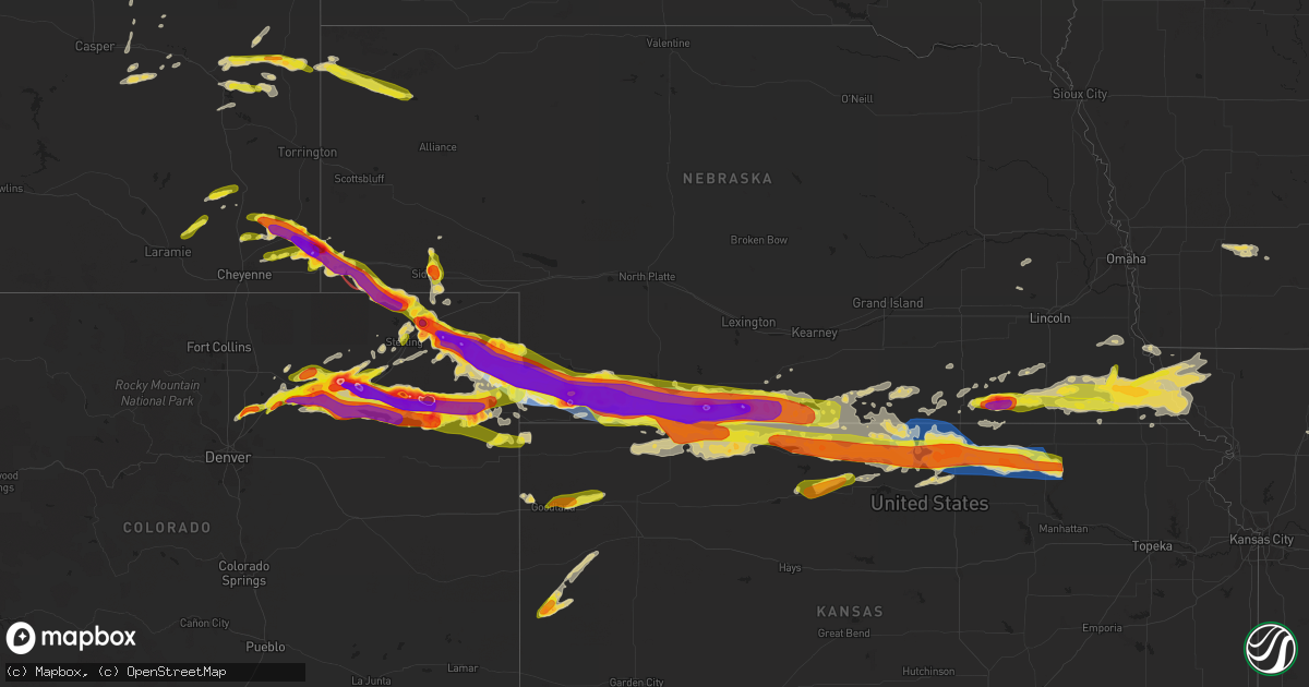
Hail Map on June 28, 2023
Get this storm
June 28 map
$229
one time, instant access
Download today. No call, no setup
Keep the $229
Bought the map and want the full workflow? Apply the entire $229 to a subscription within 7 days. None of it is wasted.
Every map, not just this one
This buys you this map. Subscription and you get every map we run, in the markets you choose from a few cities to whole states to nationwide. Plus real-time alerts the moment a storm fires.
Contact data
Name, contact info, occupancy, even credit band for addresses in the footprint. You go from where it hit to who to call.
Become the source they trust
Unlimited branding weather history reports on demand. You already have the documented answer ready for the property owner, and you are the one who showed up with it.
Property data and RoofTrace estimates
Pull up any address you have got, its value and the exact code rules for that jurisdiction, straight from One Click Code. Then RoofTrace estimates the squares, pitch, and roof value, priced the way you price.
States Impacted by Hail Map on June 28, 2023
Storm reports
Nebraska
| Date | Description |
|---|---|
| 06/28/20235:46 PM CDT | Quarter sized hail reported in harrison... Ne. |
| 06/28/202312:55 PM CDT | Corrects previous hail report from 6 sw champion from mdt to cdt. Public reports hail a little less than golf ball sized... Crop damage... Time estimated by radar. |
| 06/28/202312:50 PM CDT | Corrects previous hail report from 6 ssw champion from mdt to cdt. Public reports extended period of hail... Quarter sized and smaller... Stripped corn and crop. |
| 06/28/20236:58 AM CDT | Report from mping: 1-inch tree limbs broken; shingles blown off. |
| 06/28/20236:32 AM CDT | A personal weather station measured a peak wind gust of 59 mph. |
| 06/28/20235:25 AM CDT | Large tree uprooted. |
| 06/28/20234:58 AM CDT | A local report indicates 2.50 inch wind near 1 WNW Fairbury |
| 06/28/20234:57 AM CDT | A local report indicates 1.00 inch wind near 1 NW Fairbury |
| 06/28/20234:55 AM CDT | A local report indicates 2.00 inch wind near 1 NNW Fairbury |
| 06/28/20234:01 AM CDT | Delayed report from facebook. Time estimated. |
| 06/28/20234:00 AM CDT | Mesonet pws-kneorlea4. |
| 06/28/20233:58 AM CDT | Received photos via social media of trees down in alma. Wind estimated to 60+ mph. |
| 06/28/20233:58 AM CDT | Numerous large tree limbs down around town with several fully grown trees blown over. Significant damage to a few out buildings. Likely strong straight line wind damage |
| 06/28/20233:55 AM CDT | Observer reports broken windows from a combination of hail up to ping pong ball size and winds estimated around 70 mph. |
| 06/28/20233:55 AM CDT | Observer reports broken windows from a combination of hail up to ping pong ball size and winds estimated around 70 mph. |
| 06/28/20233:50 AM CDT | Mesonet wl-orleans1.5wnw. |
| 06/28/20233:41 AM CDT | Delayed report from facebook. All west facing windows of home broken... Including a panel of a sliding glass door. Time estimated. |
| 06/28/20233:27 AM CDT | Also broke 4 to 6 diameter tree limbs. |
| 06/28/20233:25 AM CDT | Facebook report and photo showing extensive home siding damage from a combination of hail up to baseball size and strong winds. Also reports of several broken car windo |
| 06/28/20233:25 AM CDT | Facebook report and photo showing extensive home siding damage from a combination of hail up to baseball size and strong winds. Also reports of several broken car windo |
| 06/28/20233:20 AM CDT | Furnas county deputies reported significant thunderstorm damage... Including multiple windows broken... Trees down... And tree damage... Due to both large hail and seve |
| 06/28/20233:10 AM CDT | Wind driven golf ball sized hail broke 7 windows on our observers house. Many other windows were broken around town. |
| 06/28/20233:10 AM CDT | Social media report of large hail that broke windows on the west side of a home. |
| 06/28/20233:05 AM CDT | Numerous windows broken... Tree limbs snapped. |
| 06/28/20233:00 AM CDT | Delayed report of crop damage. A field of corn that was hip high was flattened. |
| 06/28/20233:00 AM CDT | Corrects previous tstm wnd gst report from 1 e cambridge. Estimated wind gusts of 60 to 70 mph. Also broke 4 to 6 inch diameter tree limbs. |
| 06/28/20232:32 AM CDT | Asos station kmck mccook airport. |
| 06/28/20232:27 AM CDT | Report from mping: quarter |
| 06/28/20232:23 AM CDT | A local report indicates 62 MPH wind near 5 SSW Mccook |
| 06/28/20232:17 AM CDT | Report of 1 inch hail 7 miles north of benkelman. |
| 06/28/20232:16 AM CDT | A local report indicates 67 MPH wind near 7 SE Culbertson |
| 06/28/20232:15 AM CDT | Mesonet station ew9525 9.5 sw mccook. |
| 06/28/20232:14 AM CDT | A local report indicates 70 MPH wind near 7 SSE Culbertson |
| 06/28/20232:12 AM CDT | A local report indicates 67 MPH wind near 7 SSE Culbertson |
| 06/28/20231:58 AM CDT | Report of mostly pea sized hail with a few ping pong ball sized stones and a 45 mph wind gust. Ground is only partially covered in hail but melting quickly with rain. |
| 06/28/20231:58 AM CDT | Delayed report from ambient weather network east of trenton... Ne with a max gust of 81 mph. |
| 06/28/20231:45 AM CDT | Delayed report of 1.5 inch hail... 70 mph winds... Broken windows and downed power lines in trenton... Ne. Started around 12:45 am mdt ended around 1:20 am mdt. |
| 06/28/20231:45 AM CDT | Delayed report of 1.5 inch hail... 70 mph winds... Broken windows and downed power lines in trenton... Ne. |
| 06/28/20231:45 AM CDT | Delayed report of 1.5 inch hail... 70 mph winds... Broken windows and downed power lines in trenton... Ne. Started around 12:45 am mdt ended around 1:20 am mdt. |
| 06/28/20231:35 AM CDT | Delayed report. Wind driven hail resulted in tree and crop damage. Time estimated by radar. |
| 06/28/20231:30 AM CDT | Largest size of ping pong sized hail starting around 12:20 am mdt. At the time of the call... Hail size had dropped slightly... Average size is around 1 inch. Ground is |
| 06/28/20231:29 AM CDT | A local report indicates 1.50 inch wind near 7 NNW Stratton |
| 06/28/20231:25 AM CDT | Delayed report of greater than 1 inch hail falling 8 miles north-northwest of stratton... Ne. |
| 06/28/20231:25 AM CDT | Report from mping: baseball+ |
| 06/28/20231:15 AM CDT | Delayed report of pea to gold ball sized hail at the swanson reservoir. Broken windows and camper damage reported. |
| 06/28/20231:03 AM CDT | Social media report of baseball sized hail 15 miles north of benkelman. Baseball sized hail is ongoing... And started about 11:57 pm mdt. |
| 06/28/202312:45 AM CDT | Hail to at least ping pong ball size. This was an isolated storm a few hours prior to the more damaging storm complex. |
| 06/28/202312:30 AM CDT | Delayed report. Small hail also occured. Time estimated by radar. |
| 06/27/202311:55 PM CDT | Public reports hail a little less than golf ball sized... Crop damage... Time estimated by radar. |
| 06/27/202311:50 PM CDT | Public reports extended period of hail... Quarter sized and smaller... Stripped corn and crop. |
| 06/27/20238:33 PM CDT | Report from mping: quarter |
| 06/27/20238:25 PM CDT | Facebook image and estimated hail size east of sidney. |
| 06/27/20237:49 PM CDT | Facebook report of the approximate latitude and longitude of the tornado end point this evening. |
| 06/27/20237:39 PM CDT | Large tornado on the ground. |
| 06/27/20237:37 PM CDT | Nws employee reported large tornado on the ground. |
| 06/27/20237:35 PM CDT | Facebook report of the approximate latitude and longitude of the tornado touchdown this evening. |
Arizona
| Date | Description |
|---|---|
| 06/28/20234:03 PM CDT | Delayed report. Mesonet station azt15 bowie. |
North Dakota
| Date | Description |
|---|---|
| 06/28/20235:45 PM CDT | 4 sw belcourt raws station. Report of penny sized hail received via facebook. Time estimated based on radar. |
| 06/27/20238:20 PM CDT | The hail covered the ground. |
| 06/27/20238:00 PM CDT | Mostly nickel size... A few quarters. |
Indiana
| Date | Description |
|---|---|
| 06/28/20236:49 AM CDT | Relayed to dispatch via social media. Time estimated via radar. |
| 06/28/20236:45 AM CDT | Two reports near the same location. |
| 06/28/20236:43 AM CDT | Tree of unknown size or condition downed on niblack road. Time estimated from radar. |
| 06/28/20236:17 AM CDT | Time estimated via radar. |
| 06/28/20235:19 AM CDT | Report from mping: quarter |
Texas
| Date | Description |
|---|---|
| 06/27/20238:07 PM CDT | Severe gusts occurred from 759 pm cdt through 809 pm cdt with a peak gust of 70 mph at 807 pm cdt. |
Wisconsin
| Date | Description |
|---|---|
| 06/28/202312:50 AM CDT | Quarter to golfball size hail covering ground. Relayed via wqow. |
| 06/28/202312:05 AM CDT | Pictures received of trailers moved and thrown and damage to trees. Very local area about one-half mile in diameter. |
| 06/27/20239:06 PM CDT | Delayed report from em. Time estimated via radar. |
Florida
| Date | Description |
|---|---|
| 06/28/20236:35 PM CDT | Broadcast media relayed report from home weather station of 60 mph wind gust. Other minor damage reported in the vicinity. |
| 06/28/20232:55 PM CDT | Ussf tower 20 measured a wind gust of 52kt/60mph from the northwest. |
Kansas
| Date | Description |
|---|---|
| 06/28/20236:55 AM CDT | Six-inch tree limbs blown down. Time estimated based on radar. |
| 06/28/20236:50 AM CDT | Power lines down in waterville. Time estimated from radar. |
| 06/28/20236:40 AM CDT | A tree limb at least six inches in diameter knocked down. |
| 06/28/20236:39 AM CDT | Report from mping: quarter |
| 06/28/20236:34 AM CDT | Report from mping: ping pong ball |
| 06/28/20236:34 AM CDT | A local report indicates 1.25 inch wind near 4 SSE Morrowville |
| 06/28/20236:20 AM CDT | Delayed report: portion of roof lifted off of large metal outbuilding. Time estimated from radar. |
| 06/28/20236:11 AM CDT | Delayed report: 15 power poles snapped on eagle road. Time estimated from radar. |
| 06/28/20236:11 AM CDT | Delayed report: outbuilding destroyed. Time estimated from radar. |
| 06/28/20236:11 AM CDT | Corrects previous tstm wnd dmg report from 8 n clifton. Delayed report: 15 power poles snapped on eagle road. Time estimated from radar. |
| 06/28/20236:10 AM CDT | Delayed report: significant damage to home and barn... With roof damage. Time estimated from radar. |
| 06/28/20236:10 AM CDT | Corrects previous tstm wnd dmg report from 1 wsw linn. A tree limb at least 10 inches in diameter knocked down. |
| 06/28/20236:10 AM CDT | Delayed report: numerous large trees snapped... Estimating 10 inch width. House took some damage from broken trees. Time estimated from radar. |
| 06/28/20236:08 AM CDT | Delayed report: large tree w/ estimated diameter over 12 inches uprooted in pasture. Time estimated from radar. |
| 06/28/20236:03 AM CDT | Delayed report: large metal outbuilding suffered partial wall and roof damage. Some trees snapped. House suffered minor roof damage. Time estimated from radar. |
| 06/28/20235:55 AM CDT | A local report indicates 66 MPH wind near 2 W Belleville |
| 06/28/20235:31 AM CDT | Delayed report from mesonet station near lovewell reservoir. |
| 06/28/20235:30 AM CDT | Farm coop employee reports some tree limbs down around town...some as large as 6 inch diameter. Time estimated from radar and nearby mesonet data. |
| 06/28/20235:30 AM CDT | Delayed report via facebook of damage to an outbuilding 5 miles east of mankato. Time est from radar and other area lsrs. |
| 06/28/20234:35 AM CDT | Facebook photo of a small tree or a large branch that fell onto a vehicle. Time estimated from radar. |
| 06/28/20234:24 AM CDT | A local report indicates 1.00 inch wind near 1 SSW Norton |
| 06/28/20234:21 AM CDT | Quarter size hail in goodland. |
| 06/28/20234:20 AM CDT | 1.25 inch diameter hail measured at nws goodland. |
| 06/28/20234:20 AM CDT | Delayed report of 1 to 1.5 inch hail 2 miles south of norton. |
| 06/28/20234:19 AM CDT | Report from mping: quarter |
| 06/28/20234:16 AM CDT | 1 inch diameter hail measured at nws goodland. |
| 06/28/20234:16 AM CDT | Kphg awos. |
| 06/28/20234:15 AM CDT | Delayed report of wind driven hail breaking house windows and blowing over a wooden privacy fence. |
| 06/28/20234:15 AM CDT | Delayed report of 1 inch hail in goodland. |
| 06/28/20234:15 AM CDT | Delayed report. Off duty employee reports healthy tree limb around 6 inches in diameter down. Time estimated from radar. |
| 06/28/20234:15 AM CDT | Delayed report. Off duty employee reports healthy tree limb around 4 inches in diameter down. Time estimated from radar. |
| 06/28/20234:14 AM CDT | Delayed report of 1.5 inch hail in goodland. |
| 06/28/20234:14 AM CDT | Delayed report. Off duty employee reports healthy tree limbs around 2 inches in diameter down. Time estimated from radar. |
| 06/28/20234:14 AM CDT | Delayed report. Off duty employee reports healthy tree limbs around 2 inches in diameter down. Time estimated from radar. |
| 06/28/20234:13 AM CDT | Delayed report of large branches being downed. Unknown size of branches. |
| 06/28/20234:13 AM CDT | Corrects previous tstm wnd dmg report from goodland. Delayed report of large branches being downed. Photos received look like 4-6 inch branches were blown down. |
| 06/28/20234:13 AM CDT | Delayed report of 1.25 inch hail in goodland... Ks. Large branches were also reported being down. |
| 06/28/20234:13 AM CDT | Asos station kgld goodland. |
| 06/28/20233:55 AM CDT | Report from mping: quarter |
| 06/28/20232:36 AM CDT | A local report indicates 63 MPH wind near 7 WSW Danbury |
| 06/27/20238:43 PM CDT | Reported ping pong ball to slightly larger hail just ended. |
| 06/27/20238:43 PM CDT | Corrects previous hail report from 5 nne tribune. Reported ping pong ball to slightly larger hail just ended. Photos sent via social media of measured hail 1.25 to 1.75 |
| 06/27/20237:30 PM CDT | A local report indicates 1.75 inch wind near 17 NNW Manter |
Wyoming
| Date | Description |
|---|---|
| 06/28/20236:40 PM CDT | A local report indicates 4.00 inch wind near 8 S Albin |
| 06/28/20236:26 PM CDT | Baseball hail reported per trained spotter. |
| 06/28/20236:13 PM CDT | Trained storm spotter reports upwards of lime to tennis ball size hail west of albin. |
| 06/28/20236:05 PM CDT | A local report indicates 1.00 inch wind near Gun Barrel |
| 06/28/20236:01 PM CDT | Emergency manager reported inflow winds around 60 mph. |
| 06/28/20236:00 PM CDT | Report from mping: ping pong ball |
| 06/28/20235:45 PM CDT | A local report indicates 60 MPH wind near Gun Barrel |
| 06/28/20234:39 PM CDT | Hail in lusk varied from pennies to half dollars to ping pong ball sized. |
| 06/28/20234:30 PM CDT | Mostly pea to dime size hail |
| 06/28/20232:35 PM CDT | A local report indicates 1.50 inch wind near 13 NNE Kaycee |
Illinois
| Date | Description |
|---|---|
| 06/28/20236:49 AM CDT | Time estimated by radar. |
| 06/28/20236:18 AM CDT | Time estimated by radar. |
| 06/28/20236:15 AM CDT | Ping pong to golf ball sized hail. Time estimated by radar. |
| 06/28/20236:15 AM CDT | A local report indicates 1.00 inch wind near 4 S Mansfield |
| 06/28/20236:01 AM CDT | Swop report... Time estimated by radar. |
| 06/28/20235:52 AM CDT | I-74 and il 54 in farmer city... Il. |
| 06/28/20235:31 AM CDT | A local report indicates 1.25 inch wind near 5 E Heyworth |
| 06/28/20234:30 AM CDT | Report from mping: ping pong ball |
| 06/28/20234:30 AM CDT | Emergency manager relayed report from spotter in congerville... Il |
| 06/28/20234:26 AM CDT | Report from mping: half dollar |
| 06/28/20234:10 AM CDT | Photo shared on social media of hail measuring 1 inch in diameter. |
| 06/28/20234:09 AM CDT | A local report indicates 1.00 inch wind near Toledo |
| 06/28/20233:59 AM CDT | Report from mping: quarter |
| 06/28/20233:50 AM CDT | Photo relayed via social media. |
| 06/28/20233:48 AM CDT | Viewer photo report from week news. |
| 06/28/20233:47 AM CDT | Report from mping: quarter |
| 06/28/20233:32 AM CDT | [delayed report] photo shared of quarter size hail that fell near the intersection of spring creek rd. And perryville rd. In rockford. |
| 06/28/20233:26 AM CDT | Time estimated by radar. |
| 06/28/20233:24 AM CDT | Report from mping: half dollar |
| 06/28/20233:22 AM CDT | Photo showed hail at least 2 inches in diameter. Time estimated by radar. |
| 06/28/20233:22 AM CDT | Picture relayed from broadcast media showed hail of at least golf ball size. Time estimated by radar. |
Colorado
| Date | Description |
|---|---|
| 06/28/20235:56 PM CDT | Asos station kspd 8 s springfield. |
| 06/28/20233:00 AM CDT | Delayed report of golf ball sized hail for about a minute followed by 5 minutes of nickel to ping pong ball sized hail. |
| 06/28/20233:00 AM CDT | Corrects previous hail report from eckley. Delayed report of golf ball sized hail for about a minute followed by 5 minutes of nickel to ping pong ball sized hail 8 mile |
| 06/28/20232:20 AM CDT | A local report indicates 2.50 inch wind near 9 S Otis |
| 06/28/20231:45 AM CDT | Delayed report with photos of 2 inch hail in eckley... Co. |
| 06/28/20231:41 AM CDT | Spotter network report of 1.50 inch |
| 06/28/20231:40 AM CDT | Report from mping: quarter |
| 06/28/20231:29 AM CDT | A local report indicates 2.50 inch wind near Otis |
| 06/28/20231:28 AM CDT | A local report indicates 2.00 inch wind near Otis |
| 06/28/20231:26 AM CDT | A local report indicates 2.50 inch wind near Otis |
| 06/28/20231:23 AM CDT | Social media post of the hail with a tape measure. |
| 06/28/20231:15 AM CDT | A local report indicates 2.50 inch wind near Platner |
| 06/28/20231:10 AM CDT | A local report indicates 2.00 inch wind near 7 NE Otis |
| 06/28/20231:01 AM CDT | A local report indicates 2.50 inch wind near 2 SE Akron |
| 06/28/20231:00 AM CDT | A local report indicates 4.00 inch wind near Otis |
| 06/28/20231:00 AM CDT | A local report indicates 3.00 inch wind near Akron |
| 06/28/20231:00 AM CDT | A local report indicates 4.00 inch wind near akron |
| 06/28/202312:58 AM CDT | A local report indicates 3.00 inch wind near 1 NW Akron |
| 06/28/202312:54 AM CDT | A local report indicates 3.00 inch wind near 1 NW Akron |
| 06/28/202312:54 AM CDT | A local report indicates 2.50 inch wind near 5 W Akron |
| 06/28/202312:45 AM CDT | Large hail stones 15-20 feet apart. |
| 06/28/202312:37 AM CDT | A local report indicates 1.00 inch wind near Wiggins |
| 06/28/202312:30 AM CDT | Car dents... Shingles damaged... Shredded leaves. |
| 06/28/202312:30 AM CDT | A local report indicates 2.00 inch wind near Wiggins |
| 06/28/202312:16 AM CDT | Report from mping: baseball |
| 06/28/202312:15 AM CDT | Delayed report of 1.5 inch hail in wauneta that destroyed a wind shield. A minute followed by 5 minutes of nickel to ping p |
| 06/28/202312:15 AM CDT | Delayed report of 1.5 inch hail in wauneta that destroyed a wind shield. |
| 06/28/202312:07 AM CDT | Twitter post of hail slightly larger than a baseball. |
| 06/28/202312:05 AM CDT | A local report indicates 1.75 inch wind near 12 SE Holyoke |
| 06/28/202312:05 AM CDT | A local report indicates 2.75 inch wind near 3 WSW Brush |
| 06/28/202312:00 AM CDT | Time estimate based on radar. |
| 06/28/202312:00 AM CDT | Report from mping: tennis ball |
| 06/28/202312:00 AM CDT | Report from mping: baseball |
| 06/27/202311:59 PM CDT | Windows broken... Car damage... Trees shredded. 0.9 inch rainfall. |
| 06/27/202311:54 PM CDT | A local report indicates 2.75 inch wind near 1 WNW Log Lane Village |
| 06/27/202311:52 PM CDT | 18 inch diameter tree snapped in downtown brush. |
| 06/27/202311:52 PM CDT | A local report indicates 3.00 inch wind near 2 N Fort Morgan |
| 06/27/202311:47 PM CDT | A local report indicates 2.00 inch wind near 2 NNE Fort Morgan |
| 06/27/202311:45 PM CDT | A local report indicates 1.75 inch wind near 6 SE Holyoke |
| 06/27/202311:45 PM CDT | A local report indicates 82 MPH wind near 6 SE Holyoke |
| 06/27/202311:41 PM CDT | Twitter post showing 3 inch hail. |
| 06/27/202311:37 PM CDT | A local report indicates 2.50 inch wind near 1 WNW Log Lane Village |
| 06/27/202311:32 PM CDT | A local report indicates 1.75 inch wind near Holyoke |
| 06/27/202311:28 PM CDT | Time estimate based on radar. |
| 06/27/202311:26 PM CDT | Dents in car. Time estimated. |
| 06/27/202311:25 PM CDT | A local report indicates 1.25 inch wind near SW Holyoke |
| 06/27/202311:22 PM CDT | A local report indicates 81 MPH wind near 8 S Holyoke |
| 06/27/202311:12 PM CDT | Report from mping: quarter |
| 06/27/202311:11 PM CDT | A local report indicates 1.25 inch wind near Sterling |
| 06/27/202311:08 PM CDT | A local report indicates 1.00 inch wind near Sterling |
| 06/27/202311:03 PM CDT | A local report indicates 1.00 inch wind near Sterling |
| 06/27/202310:37 PM CDT | A local report indicates 1.00 inch wind near 1 N Haxtun |
| 06/27/202310:32 PM CDT | A local report indicates 2.75 inch wind near Haxtun |
| 06/27/202310:28 PM CDT | A local report indicates 1.75 inch wind near 1 N Haxtun |
| 06/27/202310:25 PM CDT | Report from mping: quarter |
| 06/27/202310:13 PM CDT | Report from mping: baseball |
| 06/27/202310:00 PM CDT | A local report indicates 2.50 inch wind near 9 NE Westplains |
| 06/27/20239:54 PM CDT | Report from mping: hen egg+ |
| 06/27/20239:54 PM CDT | Report from mping: hen egg |
| 06/27/20239:34 PM CDT | A local report indicates 3.00 inch wind near 3 NE Iliff |
| 06/27/20239:34 PM CDT | Radar used to estimate time. |
| 06/27/20239:13 PM CDT | Corrects previous tornado report from 3 ene iliff. Twitter. |
South Dakota
| Date | Description |
|---|---|
| 06/28/20235:47 PM CDT | A local report indicates 1.75 inch wind near 4 SE Folsom |
| 06/28/20235:21 PM CDT | Mostly dimes with some quarters. |
| 06/28/20234:34 PM CDT | Mping report |
| 06/28/20234:20 PM CDT | A local report indicates 1.50 inch wind near 1 E Dwtn Rapid City |
| 06/28/20234:20 PM CDT | A local report indicates 1.50 inch wind near 2 S Dwtn Rapid City |
| 06/28/20234:17 PM CDT | A local report indicates 1.75 inch wind near 1 S Dwtn Rapid City |
| 06/28/20234:00 PM CDT | A local report indicates 1.00 inch wind near Tilford |
| 06/28/20233:30 PM CDT | Mping report |
| 06/28/20233:25 PM CDT | A local report indicates 1.00 inch wind near Box Elder |
| 06/28/20233:17 PM CDT | A local report indicates 1.50 inch wind near 4 N Dwtn Rapid City |
| 06/28/20233:10 PM CDT | A local report indicates 1.25 inch wind near 4 N Dwtn Rapid City |
| 06/28/20232:43 PM CDT | A local report indicates 1.00 inch wind near 5 E Dwtn Rapid City |
| 06/27/20238:31 PM CDT | A local report indicates 70 MPH wind near 13 NW Belle Fourche |
| 06/27/20238:31 PM CDT | A local report indicates 1.50 inch wind near 13 NW Belle Fourche |
| 06/27/20238:31 PM CDT | A local report indicates 1.50 inch wind near 13 NW Belle Fourche |
Cities Impacted by Hail Map on June 28, 2023
- Anita, IA
- Wiota, IA
- Massena, IA
- Bridgewater, IA
- Atlantic, IA
- Gallatin, MO
- Altamont, MO
- Fairfax, MO
- Rock Port, MO
- Fontanelle, IA
- Cumberland, IA
- Greenfield, IA
- Rapid City, SD
- Box Elder, SD
- Black Hawk, SD
- Ellsworth Afb, SD
- New Underwood, SD
- Kaycee, WY
- Sturgis, SD
- Piedmont, SD
- Gillette, WY
- Glendo, WY
- Caputa, SD
- Shawnee, WY
- Manville, WY
- Lusk, WY
- Leeds, ND
- Bisbee, ND
- Cando, ND
- Churchs Ferry, ND
- Bottineau, ND
- Dunseith, ND
- Hermosa, SD
- Cheyenne, WY
- Lagrange, WY
- Meriden, WY
- Chugwater, WY
- Wheatland, WY
- Devils Lake, ND
- Penn, ND
- Belcourt, ND
- Harrison, NE
- Scenic, SD
- Burns, WY
- Albin, WY
- Pine Bluffs, WY
- Crawford, NE
- Granville, ND
- Walhalla, ND
- Lansford, ND
- Starkweather, ND
- Buffalo, WY
- Kramer, ND
- Souris, ND
- Newcastle, WY
- Osage, WY
- Munich, ND
- Rolla, ND
- Westhope, ND
- San Simon, AZ
- Bowie, AZ
- Deadwood, SD
- Big Sandy, MT
- Maxbass, ND
- Ruso, ND
- Beulah, ND
- Cavalier, ND
- Mylo, ND
- York, ND
- Hobson, MT
- Egeland, ND
- Denton, MT
- Butte, ND
- Elfrida, AZ
- Nemo, SD
- New Salem, ND
- Voltaire, ND
- Eustis, FL
- Edgewater, FL
- Oak Hill, FL
- Osteen, FL
- Venus, FL
- Sarles, ND
- Winnett, MT
- Upton, WY
- Marsland, NE
- Keystone, SD
- Bushnell, NE
- Kimball, NE
- Manter, KS
- Johnson, KS
- Syracuse, KS
- Kendall, KS
- Lakin, KS
- Pekin, ND
- Mchenry, ND
- Binford, ND
- Mcville, ND
- Jessie, ND
- Cooperstown, ND
- Belle Fourche, SD
- Ulysses, KS
- Dix, NE
- Padroni, CO
- Peetz, CO
- Sidney, NE
- Gurley, NE
- Tribune, KS
- Iliff, CO
- Crook, CO
- Laramie, WY
- Fleming, CO
- Haxtun, CO
- Baldwin, WI
- Spring Valley, WI
- Woodville, WI
- Wilson, WI
- Kersey, CO
- Orchard, CO
- Elmwood, WI
- Menomonie, WI
- Weldona, CO
- Libby, MT
- Otter, MT
- Lakota, ND
- Glendive, MT
- Sorrento, FL
- Worden, MT
- Pompeys Pillar, MT
- Ballantine, MT
- Tower City, ND
- Douglas, WY
- Glenrock, WY
- Labelle, FL
- Hoople, ND
- Warwick, ND
- Nevada City, CA
- Sheridan, WY
- Hensel, ND
- Page, ND
- Pillsbury, ND
- New Rockford, ND
- Tolna, ND
- Brusett, MT
- New Richmond, WI
- Jay Em, WY
- Wolford, ND
- Orlando, FL
- River Falls, WI
- Sheyenne, ND
- Saint Michael, ND
- Lodgepole, NE
- Oriska, ND
- Hope, ND
- Luverne, ND
- North Fort Myers, FL
- Alva, FL
- Punta Gorda, FL
- Lawton, ND
- Brocket, ND
- Hammond, WI
- Roberts, WI
- Glenwood City, WI
- Fort Lupton, CO
- Keenesburg, CO
- Holyoke, CO
- Paoli, CO
- Fort Morgan, CO
- Yuma, CO
- Amherst, CO
- Roggen, CO
- Snyder, CO
- Hudson, CO
- Brush, CO
- Wiggins, CO
- Wray, CO
- Champion, NE
- Strum, WI
- Mondovi, WI
- Eleva, WI
- Haigler, NE
- Parks, NE
- Benkelman, NE
- Akron, CO
- Hillrose, CO
- Whitehall, WI
- Independence, WI
- Osseo, WI
- Hixton, WI
- Imperial, NE
- Otis, CO
- Wauneta, NE
- Beaver City, NE
- Hendley, NE
- Edison, NE
- Oxford, NE
- Enders, NE
- Max, NE
- Stratton, NE
- Palisade, NE
- Blair, WI
- Taylor, WI
- Black River Falls, WI
- Woodrow, CO
- McDonald, KS
- Atwood, KS
- Trenton, NE
- Culbertson, NE
- Hayes Center, NE
- Eckley, CO
- McCook, NE
- Indianola, NE
- Danbury, NE
- Herndon, KS
- Oberlin, KS
- Log Lane Village, CO
- Vernon, CO
- Bartley, NE
- Cambridge, NE
- Lebanon, NE
- Wilsonville, NE
- Norcatur, KS
- Holbrook, NE
- Rockford, IL
- Machesney Park, IL
- Loves Park, IL
- Belvidere, IL
- Caledonia, IL
- Roscoe, IL
- Rockton, IL
- Norton, KS
- Arapahoe, NE
- Stamford, NE
- Orleans, NE
- Poplar Grove, IL
- Groveland, IL
- Pekin, IL
- Tremont, IL
- Garden Prairie, IL
- Alma, NE
- Prairie View, KS
- Phillipsburg, KS
- Almena, KS
- Long Island, KS
- Idalia, CO
- Saint Francis, KS
- Morton, IL
- Hulett, WY
- Leoti, KS
- Merino, CO
- Rice Lake, WI
- Sterling, CO
- Dazey, ND
- Almont, ND
- Granada, CO
- Holly, CO
- Langdon, ND
- Durand, WI
- Harrisburg, NE
- New Raymer, CO
- Eau Galle, WI
- Wallace, KS
- Alzada, MT
- Somerset, WI
- Riverton, NE
- Brighton, CO
- Bladen, NE
- Campbell, NE
- Franklin, NE
- Bloomington, NE
- Winona, KS
- Dalton, NE
- Atwood, CO
- La Salle, CO
- Moorcroft, WY
- Sharon Springs, KS
- Spooner, WI
- Birchwood, WI
- Haugen, WI
- Sarona, WI
- Goodland, KS
- Agra, KS
- Republican City, NE
- Naponee, NE
- Deer Creek, IL
- Goodfield, IL
- Hopedale, IL
- Mackinaw, IL
- Minier, IL
- Stanford, IL
- Danvers, IL
- Congerville, IL
- Edson, KS
- Carlock, IL
- Secor, IL
- El Paso, IL
- Hudson, IL
- Brewster, KS
- Athol, KS
- Kensington, KS
- Smith Center, KS
- Gaylord, KS
- Portis, KS
- Lebanon, KS
- Fairbury, NE
- Hebron, NE
- Gilead, NE
- Gridley, IL
- Lexington, IL
- Toledo, IL
- Trilla, IL
- Neoga, IL
- Greenup, IL
- Lerna, IL
- Paris, IL
- Vermilion, IL
- West Terre Haute, IN
- Clinton, IN
- Chenoa, IL
- Marengo, IL
- Jansen, NE
- Diller, NE
- Esbon, KS
- Mankato, KS
- Burr Oak, KS
- Levant, KS
- Colby, KS
- New Goshen, IN
- Bloomington, IL
- Downs, IL
- Le Roy, IL
- Farmer City, IL
- Rosedale, IN
- Terre Haute, IN
- Beatrice, NE
- Blue Springs, NE
- Odell, NE
- Virginia, NE
- Filley, NE
- Elk Creek, NE
- Johnson, NE
- Tecumseh, NE
- Auburn, NE
- Jewell, KS
- Webber, KS
- Norway, KS
- Formoso, KS
- Courtland, KS
- Scandia, KS
- Jamestown, KS
- Superior, NE
- Belleville, KS
- Byron, NE
- Republic, KS
- Hardy, NE
- Concordia, KS
- Stockton, KS
- Woodston, KS
- Alton, KS
- Arrowsmith, IL
- Osborne, KS
- Agenda, KS
- Hanover, KS
- Bremen, KS
- Washington, KS
- Morrowville, KS
- Marysville, KS
- Wymore, NE
- Burchard, NE
- Liberty, NE
- Steinauer, NE
- Pawnee City, NE
- Mansfield, IL
- White Heath, IL
- De Land, IL
- Cisco, IL
- Monticello, IL
- Crab Orchard, NE
- Lewiston, NE
- Table Rock, NE
- Dawson, NE
- Humboldt, NE
- Stella, NE
- Mahomet, IL
- Brock, NE
- Brownville, NE
- Nemaha, NE
- Seymour, IL
- Sullivan, IN
- Shelburn, IN
- Merom, IN
- Coalmont, IN
- Lewis, IN
- Jasonville, IN
- Hymera, IN
- Champaign, IL
- Clifton, KS
- Clyde, KS
- Cuba, KS
- Haddam, KS
- Linn, KS
- Greenleaf, KS
- Munden, KS
- Palmer, KS
- Narka, KS
- Barnes, KS
- Waterville, KS
- Shubert, NE
- Falls City, NE
- Dennison, IL
- Worthington, IN
- Coal City, IN
- Clay City, IN
- Freedom, IN
- Lawrenceville, IL
- Saint Francisville, IL
- Blue Rapids, KS
- Frankfort, KS
- Tuscola, IL
- Villa Grove, IL
- Camargo, IL
- Vincennes, IN
- Decker, IN
- Home, KS
- Geneva, NE
- Shickley, NE
- Tolono, IL
- Pesotum, IL
- Roanoke, IL
- Holdrege, NE
- Beloit, KS
- Salem, NE
- Kanorado, KS
- Graymont, IL
- Flanagan, IL
- Alexandria, NE
- Linton, IN
- Mattoon, IL
- Gays, IL
- Lenora, KS
- Guide Rock, NE
- Westboro, MO
- Elmo, MO
- Centerpoint, IN
- Brazil, IN
- Adams, NE
- McLean, IL
- Shirley, IL
- Nelson, NE
- Lawrence, NE
- Robinson, IL
- Stoy, IL
- Oblong, IL
- Carleton, NE
- Belvidere, NE
- Downs, KS
- Marshall, IL
- Tarkio, MO
- Skidmore, MO
- Hubbell, NE
- Verdon, NE
- Rulo, NE
- Craig, MO
- Burlington Junction, MO
- Windsor, IL
- Findlay, IL
- Argenta, IL
- Charleston, IL
- De Witt, NE
- Bee, NE
- Clayton, KS
- Ruskin, NE
- Mahaska, KS
- Reynolds, NE
- Clatonia, NE
- Pickrell, NE
- Cortland, NE
- Atlanta, NE
- Weldon, IL
- Bement, IL
- Whitewater, WI
- Blue Hill, NE
- Prague, NE
- Bruno, NE
- Brainard, NE
- Jewett, IL
- Fort Atkinson, WI
- Carlisle, IN
- Hamburg, IA
- Bridgeport, IL
- Odell, IL
- Daykin, NE
- Western, NE
- Syracuse, NE
- Dunbar, NE
- Heyworth, IL
- Deshler, NE
- Flat Rock, IL
- Ashmore, IL
- Sumner, IL
- Monroe City, IN
- Petersburg, IN
- Hazleton, IN
- Morrill, KS
- Hiawatha, KS
- Casey, IL
- Durand, IL
- Shirland, IL
- Swanton, NE
- Peoria, IL
- Oak, NE
- Davenport, NE
- Claremont, IL
- Red Cloud, NE
- Talmage, NE
- Allendale, IL
- Pontiac, IL
- Palestine, IL
- West Liberty, IL
- Willow Hill, IL
- Newton, IL
- Hutsonville, IL
- Jennings, KS
- Kansas, IL
- Westfield, IL
- Strasburg, IL
- Inavale, NE
- Randall, KS
- Atwood, IL
- Sadorus, IL
- Baileyville, KS
- Ivesdale, IL
- Mound City, MO
- Switz City, IN
- Oaktown, IN
- Nebraska City, NE
- Humboldt, IL
- Arcola, IL