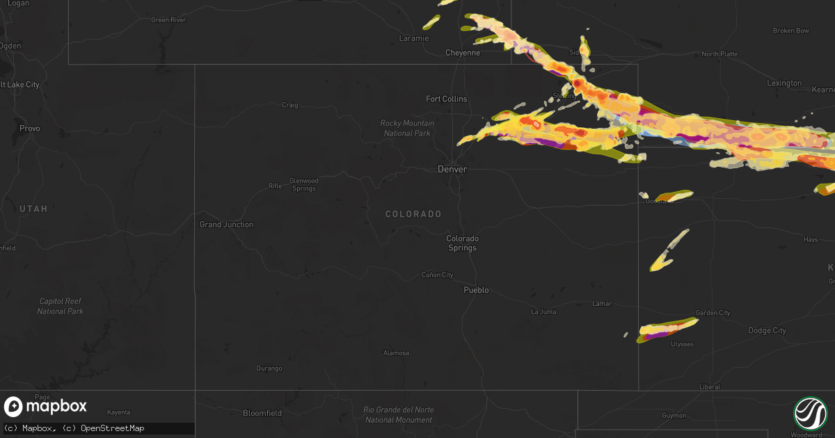
Hail Map in Colorado on June 28, 2023
Get this storm
June 28 map
$229
one time, instant access
Download today. No call, no setup
Keep the $229
Bought the map and want the full workflow? Apply the entire $229 to a subscription within 7 days. None of it is wasted.
Every map, not just this one
This buys you this map. Subscription and you get every map we run, in the markets you choose from a few cities to whole states to nationwide. Plus real-time alerts the moment a storm fires.
Contact data
Name, contact info, occupancy, even credit band for addresses in the footprint. You go from where it hit to who to call.
Become the source they trust
Unlimited branding weather history reports on demand. You already have the documented answer ready for the property owner, and you are the one who showed up with it.
Property data and RoofTrace estimates
Pull up any address you have got, its value and the exact code rules for that jurisdiction, straight from One Click Code. Then RoofTrace estimates the squares, pitch, and roof value, priced the way you price.
Storm reports in Colorado
Colorado
| Date | Description |
|---|---|
| 06/28/20235:56 PM CDT | Asos station kspd 8 s springfield. |
| 06/28/20233:00 AM CDT | Corrects previous hail report from eckley. Delayed report of golf ball sized hail for about a minute followed by 5 minutes of nickel to ping pong ball sized hail 8 mile |
| 06/28/20233:00 AM CDT | Delayed report of golf ball sized hail for about a minute followed by 5 minutes of nickel to ping pong ball sized hail. |
| 06/28/20232:20 AM CDT | A local report indicates 2.50 inch wind near 9 S Otis |
| 06/28/20231:45 AM CDT | Delayed report with photos of 2 inch hail in eckley... Co. |
| 06/28/20231:41 AM CDT | Spotter network report of 1.50 inch |
| 06/28/20231:40 AM CDT | Report from mping: quarter |
| 06/28/20231:29 AM CDT | A local report indicates 2.50 inch wind near Otis |
| 06/28/20231:28 AM CDT | A local report indicates 2.00 inch wind near Otis |
| 06/28/20231:26 AM CDT | A local report indicates 2.50 inch wind near Otis |
| 06/28/20231:23 AM CDT | Social media post of the hail with a tape measure. |
| 06/28/20231:15 AM CDT | A local report indicates 2.50 inch wind near Platner |
| 06/28/20231:10 AM CDT | A local report indicates 2.00 inch wind near 7 NE Otis |
| 06/28/20231:01 AM CDT | A local report indicates 2.50 inch wind near 2 SE Akron |
| 06/28/20231:00 AM CDT | A local report indicates 4.00 inch wind near Otis |
| 06/28/20231:00 AM CDT | A local report indicates 3.00 inch wind near Akron |
| 06/28/20231:00 AM CDT | A local report indicates 4.00 inch wind near akron |
| 06/28/202312:58 AM CDT | A local report indicates 3.00 inch wind near 1 NW Akron |
| 06/28/202312:54 AM CDT | A local report indicates 3.00 inch wind near 1 NW Akron |
| 06/28/202312:54 AM CDT | A local report indicates 2.50 inch wind near 5 W Akron |
| 06/28/202312:45 AM CDT | Large hail stones 15-20 feet apart. |
| 06/28/202312:37 AM CDT | A local report indicates 1.00 inch wind near Wiggins |
| 06/28/202312:30 AM CDT | A local report indicates 2.00 inch wind near Wiggins |
| 06/28/202312:30 AM CDT | Car dents... Shingles damaged... Shredded leaves. |
| 06/28/202312:16 AM CDT | Report from mping: baseball |
| 06/28/202312:15 AM CDT | Delayed report of 1.5 inch hail in wauneta that destroyed a wind shield. A minute followed by 5 minutes of nickel to ping p |
| 06/28/202312:15 AM CDT | Delayed report of 1.5 inch hail in wauneta that destroyed a wind shield. |
| 06/28/202312:07 AM CDT | Twitter post of hail slightly larger than a baseball. |
| 06/28/202312:05 AM CDT | A local report indicates 2.75 inch wind near 3 WSW Brush |
| 06/28/202312:05 AM CDT | A local report indicates 1.75 inch wind near 12 SE Holyoke |
| 06/28/202312:00 AM CDT | Time estimate based on radar. |
| 06/28/202312:00 AM CDT | Report from mping: tennis ball |
| 06/28/202312:00 AM CDT | Report from mping: baseball |
| 06/27/202311:59 PM CDT | Windows broken... Car damage... Trees shredded. 0.9 inch rainfall. |
| 06/27/202311:54 PM CDT | A local report indicates 2.75 inch wind near 1 WNW Log Lane Village |
| 06/27/202311:52 PM CDT | 18 inch diameter tree snapped in downtown brush. |
| 06/27/202311:52 PM CDT | A local report indicates 3.00 inch wind near 2 N Fort Morgan |
| 06/27/202311:47 PM CDT | A local report indicates 2.00 inch wind near 2 NNE Fort Morgan |
| 06/27/202311:45 PM CDT | A local report indicates 82 MPH wind near 6 SE Holyoke |
| 06/27/202311:45 PM CDT | A local report indicates 1.75 inch wind near 6 SE Holyoke |
| 06/27/202311:41 PM CDT | Twitter post showing 3 inch hail. |
| 06/27/202311:37 PM CDT | A local report indicates 2.50 inch wind near 1 WNW Log Lane Village |
| 06/27/202311:32 PM CDT | A local report indicates 1.75 inch wind near Holyoke |
| 06/27/202311:28 PM CDT | Time estimate based on radar. |
| 06/27/202311:26 PM CDT | Dents in car. Time estimated. |
| 06/27/202311:25 PM CDT | A local report indicates 1.25 inch wind near SW Holyoke |
| 06/27/202311:22 PM CDT | A local report indicates 81 MPH wind near 8 S Holyoke |
| 06/27/202311:12 PM CDT | Report from mping: quarter |
| 06/27/202311:11 PM CDT | A local report indicates 1.25 inch wind near Sterling |
| 06/27/202311:08 PM CDT | A local report indicates 1.00 inch wind near Sterling |
| 06/27/202311:03 PM CDT | A local report indicates 1.00 inch wind near Sterling |
| 06/27/202310:37 PM CDT | A local report indicates 1.00 inch wind near 1 N Haxtun |
| 06/27/202310:32 PM CDT | A local report indicates 2.75 inch wind near Haxtun |
| 06/27/202310:28 PM CDT | A local report indicates 1.75 inch wind near 1 N Haxtun |
| 06/27/202310:25 PM CDT | Report from mping: quarter |
| 06/27/202310:13 PM CDT | Report from mping: baseball |
| 06/27/202310:00 PM CDT | A local report indicates 2.50 inch wind near 9 NE Westplains |
| 06/27/20239:54 PM CDT | Report from mping: hen egg |
| 06/27/20239:54 PM CDT | Report from mping: hen egg+ |
| 06/27/20239:34 PM CDT | A local report indicates 3.00 inch wind near 3 NE Iliff |
| 06/27/20239:34 PM CDT | Radar used to estimate time. |
| 06/27/20239:13 PM CDT | Corrects previous tornado report from 3 ene iliff. Twitter. |
All States Impacted by Hail Map on June 28, 2023
Cities Impacted by Hail Map on June 28, 2023
- Anita, IA
- Wiota, IA
- Massena, IA
- Bridgewater, IA
- Atlantic, IA
- Gallatin, MO
- Altamont, MO
- Fairfax, MO
- Rock Port, MO
- Fontanelle, IA
- Cumberland, IA
- Greenfield, IA
- Rapid City, SD
- Box Elder, SD
- Black Hawk, SD
- Ellsworth Afb, SD
- New Underwood, SD
- Kaycee, WY
- Sturgis, SD
- Piedmont, SD
- Gillette, WY
- Glendo, WY
- Caputa, SD
- Shawnee, WY
- Manville, WY
- Lusk, WY
- Leeds, ND
- Bisbee, ND
- Cando, ND
- Churchs Ferry, ND
- Bottineau, ND
- Dunseith, ND
- Hermosa, SD
- Cheyenne, WY
- Lagrange, WY
- Meriden, WY
- Chugwater, WY
- Wheatland, WY
- Devils Lake, ND
- Penn, ND
- Belcourt, ND
- Harrison, NE
- Scenic, SD
- Burns, WY
- Albin, WY
- Pine Bluffs, WY
- Crawford, NE
- Granville, ND
- Walhalla, ND
- Lansford, ND
- Starkweather, ND
- Buffalo, WY
- Kramer, ND
- Souris, ND
- Newcastle, WY
- Osage, WY
- Munich, ND
- Rolla, ND
- Westhope, ND
- San Simon, AZ
- Bowie, AZ
- Deadwood, SD
- Big Sandy, MT
- Maxbass, ND
- Ruso, ND
- Beulah, ND
- Cavalier, ND
- Mylo, ND
- York, ND
- Hobson, MT
- Egeland, ND
- Denton, MT
- Butte, ND
- Elfrida, AZ
- Nemo, SD
- New Salem, ND
- Voltaire, ND
- Eustis, FL
- Edgewater, FL
- Oak Hill, FL
- Osteen, FL
- Venus, FL
- Sarles, ND
- Winnett, MT
- Upton, WY
- Marsland, NE
- Keystone, SD
- Bushnell, NE
- Kimball, NE
- Manter, KS
- Johnson, KS
- Syracuse, KS
- Kendall, KS
- Lakin, KS
- Pekin, ND
- Mchenry, ND
- Binford, ND
- Mcville, ND
- Jessie, ND
- Cooperstown, ND
- Belle Fourche, SD
- Ulysses, KS
- Dix, NE
- Padroni, CO
- Peetz, CO
- Sidney, NE
- Gurley, NE
- Tribune, KS
- Iliff, CO
- Crook, CO
- Laramie, WY
- Fleming, CO
- Haxtun, CO
- Baldwin, WI
- Spring Valley, WI
- Woodville, WI
- Wilson, WI
- Kersey, CO
- Orchard, CO
- Elmwood, WI
- Menomonie, WI
- Weldona, CO
- Libby, MT
- Otter, MT
- Lakota, ND
- Glendive, MT
- Sorrento, FL
- Worden, MT
- Pompeys Pillar, MT
- Ballantine, MT
- Tower City, ND
- Douglas, WY
- Glenrock, WY
- Labelle, FL
- Hoople, ND
- Warwick, ND
- Nevada City, CA
- Sheridan, WY
- Hensel, ND
- Page, ND
- Pillsbury, ND
- New Rockford, ND
- Tolna, ND
- Brusett, MT
- New Richmond, WI
- Jay Em, WY
- Wolford, ND
- Orlando, FL
- River Falls, WI
- Sheyenne, ND
- Saint Michael, ND
- Lodgepole, NE
- Oriska, ND
- Hope, ND
- Luverne, ND
- North Fort Myers, FL
- Alva, FL
- Punta Gorda, FL
- Lawton, ND
- Brocket, ND
- Hammond, WI
- Roberts, WI
- Glenwood City, WI
- Fort Lupton, CO
- Keenesburg, CO
- Holyoke, CO
- Paoli, CO
- Fort Morgan, CO
- Yuma, CO
- Amherst, CO
- Roggen, CO
- Snyder, CO
- Hudson, CO
- Brush, CO
- Wiggins, CO
- Wray, CO
- Champion, NE
- Strum, WI
- Mondovi, WI
- Eleva, WI
- Haigler, NE
- Parks, NE
- Benkelman, NE
- Akron, CO
- Hillrose, CO
- Whitehall, WI
- Independence, WI
- Osseo, WI
- Hixton, WI
- Imperial, NE
- Otis, CO
- Wauneta, NE
- Beaver City, NE
- Hendley, NE
- Edison, NE
- Oxford, NE
- Enders, NE
- Max, NE
- Stratton, NE
- Palisade, NE
- Blair, WI
- Taylor, WI
- Black River Falls, WI
- Woodrow, CO
- McDonald, KS
- Atwood, KS
- Trenton, NE
- Culbertson, NE
- Hayes Center, NE
- Eckley, CO
- McCook, NE
- Indianola, NE
- Danbury, NE
- Herndon, KS
- Oberlin, KS
- Log Lane Village, CO
- Vernon, CO
- Bartley, NE
- Cambridge, NE
- Lebanon, NE
- Wilsonville, NE
- Norcatur, KS
- Holbrook, NE
- Rockford, IL
- Machesney Park, IL
- Loves Park, IL
- Belvidere, IL
- Caledonia, IL
- Roscoe, IL
- Rockton, IL
- Norton, KS
- Arapahoe, NE
- Stamford, NE
- Orleans, NE
- Poplar Grove, IL
- Groveland, IL
- Pekin, IL
- Tremont, IL
- Garden Prairie, IL
- Alma, NE
- Prairie View, KS
- Phillipsburg, KS
- Almena, KS
- Long Island, KS
- Idalia, CO
- Saint Francis, KS
- Morton, IL
- Hulett, WY
- Leoti, KS
- Merino, CO
- Rice Lake, WI
- Sterling, CO
- Dazey, ND
- Almont, ND
- Granada, CO
- Holly, CO
- Langdon, ND
- Durand, WI
- Harrisburg, NE
- New Raymer, CO
- Eau Galle, WI
- Wallace, KS
- Alzada, MT
- Somerset, WI
- Riverton, NE
- Brighton, CO
- Bladen, NE
- Campbell, NE
- Franklin, NE
- Bloomington, NE
- Winona, KS
- Dalton, NE
- Atwood, CO
- La Salle, CO
- Moorcroft, WY
- Sharon Springs, KS
- Spooner, WI
- Birchwood, WI
- Haugen, WI
- Sarona, WI
- Goodland, KS
- Agra, KS
- Republican City, NE
- Naponee, NE
- Deer Creek, IL
- Goodfield, IL
- Hopedale, IL
- Mackinaw, IL
- Minier, IL
- Stanford, IL
- Danvers, IL
- Congerville, IL
- Edson, KS
- Carlock, IL
- Secor, IL
- El Paso, IL
- Hudson, IL
- Brewster, KS
- Athol, KS
- Kensington, KS
- Smith Center, KS
- Gaylord, KS
- Portis, KS
- Lebanon, KS
- Fairbury, NE
- Hebron, NE
- Gilead, NE
- Gridley, IL
- Lexington, IL
- Toledo, IL
- Trilla, IL
- Neoga, IL
- Greenup, IL
- Lerna, IL
- Paris, IL
- Vermilion, IL
- West Terre Haute, IN
- Clinton, IN
- Chenoa, IL
- Marengo, IL
- Jansen, NE
- Diller, NE
- Esbon, KS
- Mankato, KS
- Burr Oak, KS
- Levant, KS
- Colby, KS
- New Goshen, IN
- Bloomington, IL
- Downs, IL
- Le Roy, IL
- Farmer City, IL
- Rosedale, IN
- Terre Haute, IN
- Beatrice, NE
- Blue Springs, NE
- Odell, NE
- Virginia, NE
- Filley, NE
- Elk Creek, NE
- Johnson, NE
- Tecumseh, NE
- Auburn, NE
- Jewell, KS
- Webber, KS
- Norway, KS
- Formoso, KS
- Courtland, KS
- Scandia, KS
- Jamestown, KS
- Superior, NE
- Belleville, KS
- Byron, NE
- Republic, KS
- Hardy, NE
- Concordia, KS
- Stockton, KS
- Woodston, KS
- Alton, KS
- Arrowsmith, IL
- Osborne, KS
- Agenda, KS
- Hanover, KS
- Bremen, KS
- Washington, KS
- Morrowville, KS
- Marysville, KS
- Wymore, NE
- Burchard, NE
- Liberty, NE
- Steinauer, NE
- Pawnee City, NE
- Mansfield, IL
- White Heath, IL
- De Land, IL
- Cisco, IL
- Monticello, IL
- Crab Orchard, NE
- Lewiston, NE
- Table Rock, NE
- Dawson, NE
- Humboldt, NE
- Stella, NE
- Mahomet, IL
- Brock, NE
- Brownville, NE
- Nemaha, NE
- Seymour, IL
- Sullivan, IN
- Shelburn, IN
- Merom, IN
- Coalmont, IN
- Lewis, IN
- Jasonville, IN
- Hymera, IN
- Champaign, IL
- Clifton, KS
- Clyde, KS
- Cuba, KS
- Haddam, KS
- Linn, KS
- Greenleaf, KS
- Munden, KS
- Palmer, KS
- Narka, KS
- Barnes, KS
- Waterville, KS
- Shubert, NE
- Falls City, NE
- Dennison, IL
- Worthington, IN
- Coal City, IN
- Clay City, IN
- Freedom, IN
- Lawrenceville, IL
- Saint Francisville, IL
- Blue Rapids, KS
- Frankfort, KS
- Tuscola, IL
- Villa Grove, IL
- Camargo, IL
- Vincennes, IN
- Decker, IN
- Home, KS
- Geneva, NE
- Shickley, NE
- Tolono, IL
- Pesotum, IL
- Roanoke, IL
- Holdrege, NE
- Beloit, KS
- Salem, NE
- Kanorado, KS
- Graymont, IL
- Flanagan, IL
- Alexandria, NE
- Linton, IN
- Mattoon, IL
- Gays, IL
- Lenora, KS
- Guide Rock, NE
- Westboro, MO
- Elmo, MO
- Centerpoint, IN
- Brazil, IN
- Adams, NE
- McLean, IL
- Shirley, IL
- Nelson, NE
- Lawrence, NE
- Robinson, IL
- Stoy, IL
- Oblong, IL
- Carleton, NE
- Belvidere, NE
- Downs, KS
- Marshall, IL
- Tarkio, MO
- Skidmore, MO
- Hubbell, NE
- Verdon, NE
- Rulo, NE
- Craig, MO
- Burlington Junction, MO
- Windsor, IL
- Findlay, IL
- Argenta, IL
- Charleston, IL
- De Witt, NE
- Bee, NE
- Clayton, KS
- Ruskin, NE
- Mahaska, KS
- Reynolds, NE
- Clatonia, NE
- Pickrell, NE
- Cortland, NE
- Atlanta, NE
- Weldon, IL
- Bement, IL
- Whitewater, WI
- Blue Hill, NE
- Prague, NE
- Bruno, NE
- Brainard, NE
- Jewett, IL
- Fort Atkinson, WI
- Carlisle, IN
- Hamburg, IA
- Bridgeport, IL
- Odell, IL
- Daykin, NE
- Western, NE
- Syracuse, NE
- Dunbar, NE
- Heyworth, IL
- Deshler, NE
- Flat Rock, IL
- Ashmore, IL
- Sumner, IL
- Monroe City, IN
- Petersburg, IN
- Hazleton, IN
- Morrill, KS
- Hiawatha, KS
- Casey, IL
- Durand, IL
- Shirland, IL
- Swanton, NE
- Peoria, IL
- Oak, NE
- Davenport, NE
- Claremont, IL
- Red Cloud, NE
- Talmage, NE
- Allendale, IL
- Pontiac, IL
- Palestine, IL
- West Liberty, IL
- Willow Hill, IL
- Newton, IL
- Hutsonville, IL
- Jennings, KS
- Kansas, IL
- Westfield, IL
- Strasburg, IL
- Inavale, NE
- Randall, KS
- Atwood, IL
- Sadorus, IL
- Baileyville, KS
- Ivesdale, IL
- Mound City, MO
- Switz City, IN
- Oaktown, IN
- Nebraska City, NE
- Humboldt, IL
- Arcola, IL


