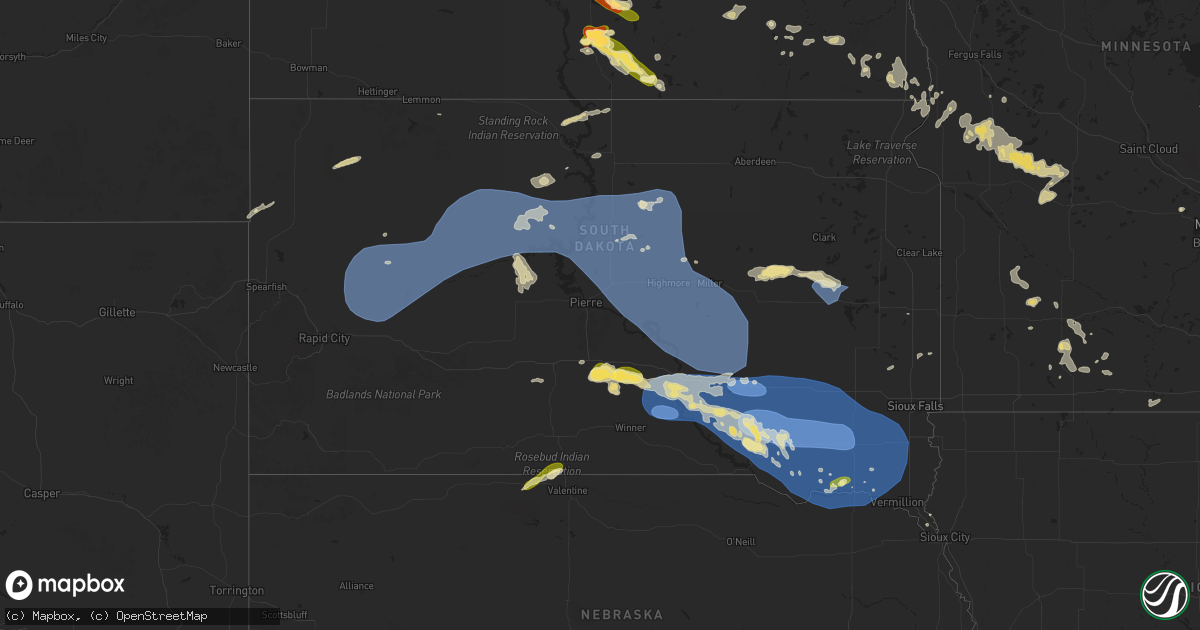
Hail Map in South Dakota on June 27, 2025
Get this storm
June 27 map
$229
one time, instant access
Download today. No call, no setup
Keep the $229
Bought the map and want the full workflow? Apply the entire $229 to a subscription within 7 days. None of it is wasted.
Every map, not just this one
This buys you this map. Subscription and you get every map we run, in the markets you choose from a few cities to whole states to nationwide. Plus real-time alerts the moment a storm fires.
Contact data
Name, contact info, occupancy, even credit band for addresses in the footprint. You go from where it hit to who to call.
Become the source they trust
Unlimited branding weather history reports on demand. You already have the documented answer ready for the property owner, and you are the one who showed up with it.
Property data and RoofTrace estimates
Pull up any address you have got, its value and the exact code rules for that jurisdiction, straight from One Click Code. Then RoofTrace estimates the squares, pitch, and roof value, priced the way you price.
Storm reports in South Dakota
South Dakota
| Date | Description |
|---|---|
| 06/27/20256:56 AM CDT | Co |
| 06/27/20256:56 AM CDT | Corrects previous non-tstm wnd gst report from 4 w erwin. Mesonet station dtms2 de smet 7n. |
| 06/27/202512:41 AM CDT | Pea to quarter size hail lasted 15 minutes. Time estimated from radar. |
| 06/26/202511:19 PM CDT | Via person |
| 06/26/202511:19 PM CDT | Via personal weather station. |
| 06/26/202510:53 PM CDT | Mesonet station 183 macs corner |
| 06/26/202510:43 PM CDT | Roof-mounted weather station measured an 83.1 mph wind gust. |
| 06/26/202510:37 PM CDT | Severe tree limbs downed by thunderstorm winds. Estimated 60 mph. |
| 06/26/202510:17 PM CDT | Mesonet station 26 sd rwis tripp. |
| 06/26/202510:15 PM CDT | Measured by a personal weather station. |
| 06/26/202510:13 PM CDT | Corrects previous tstm wnd gst report from 2 nw tripp. Mesonet station 26 sd rwis tripp. |
| 06/26/202510:03 PM CDT | Personal weather station reports peak wind gust of 60 miles per hour. Time estimated based on radar. |
| 06/26/20259:58 PM CDT | Measured by personal weather station. |
| 06/26/20259:52 PM CDT | A local report indicates 82 MPH wind near 4 E Corsica |
| 06/26/20259:49 PM CDT | Mesonet station 212 agar |
| 06/26/20259:45 PM CDT | Mesonet station onms2 onida 13wsw |
| 06/26/20259:44 PM CDT | Mesonet station 304 sd rwis corsica. |
| 06/26/20259:40 PM CDT | Mesonet station 304 sd rwis corsica. |
| 06/26/20259:38 PM CDT | Measured by personal weather station. |
| 06/26/20259:33 PM CDT | Several 4 inch diameter tree limbs down. |
| 06/26/20259:20 PM CDT | Mesonet station 214 sd rwis plankinton. |
| 06/26/20258:58 PM CDT | Mesonet station 154 sd rwis platte-winner bridge. |
| 06/26/20258:47 PM CDT | 69 mph sev |
| 06/26/20258:47 PM CDT | 69 mph severe wind measured 844 pm... 71 mph at 847 pm. Sdsu mesonet 3 nnw academy. |
| 06/26/20258:29 PM CDT | Sdsu mesonet station gregory 16n. |
| 06/26/20257:50 PM CDT | Storms lasted from 6:20 to 8:00 pm. Nickel size hail on and off. 60 mph wind gusts with the last storm that occurred at 7:50 pm. |
| 06/26/20257:25 PM CDT | A local report indicates 62 MPH wind near Union Center |
| 06/26/20257:10 PM CDT | 0.60 inches of rain and quarter size hail. Radar estimated time. |
All States Impacted by Hail Map on June 27, 2025
Cities Impacted by Hail Map on June 27, 2025
- Opheim, MT
- Richland, MT
- Larslan, MT
- Scobey, MT
- Flaxville, MT
- Lemmon, SD
- Keldron, SD
- White River, SD
- Florence, AL
- Killen, AL
- Waynesboro, TN
- Collinwood, TN
- Summertown, TN
- Lexington, AL
- Loretto, TN
- Lawrenceburg, TN
- Iron City, TN
- Cypress Inn, TN
- Cleveland, OH
- Mount Pleasant, TN
- Euclid, OH
- Columbia, TN
- Town Creek, AL
- Hampshire, TN
- Lake Worth, FL
- Bloomingdale, MI
- Bangor, MI
- Granite City, IL
- Rogersville, AL
- Vero Beach, FL
- Spring Hill, TN
- Paw Paw, MI
- Bath Springs, TN
- Scotts Hill, TN
- Campbellsville, KY
- Gobles, MI
- Miami, OK
- Fairland, OK
- Pulaski, TN
- Thompsons Station, TN
- Franklin, TN
- Cornersville, TN
- Horse Cave, KY
- Hardyville, KY
- Lawrence, MI
- Decaturville, TN
- Fort Pierce, FL
- Elkmont, AL
- Prospect, TN
- Laurel Springs, NC
- Center, KY
- Edmonton, KY
- Munfordville, KY
- Ardmore, AL
- Hillsboro, AL
- Ardmore, TN
- Shelbyville, MI
- Wayland, MI
- Middleville, MI
- Decatur, AL
- Mattoon, IL
- Trilla, IL
- Lerna, IL
- Charleston, IL
- Winfield, TN
- Greensburg, KY
- Toney, AL
- Petersburg, TN
- Nolensville, TN
- Vossburg, MS
- Shubuta, MS
- Fayetteville, TN
- Strunk, KY
- Jamestown, TN
- Canmer, KY
- Afton, OK
- Welch, OK
- Bluejacket, OK
- Murfreesboro, TN
- Meridian, MS
- Huntsville, AL
- Richton, MS
- Great Falls, MT
- Floweree, MT
- Bradyville, TN
- Wellborn, FL
- Golden Eagle, IL
- Brussels, IL
- Lake City, FL
- Live Oak, FL
- Mount Morris, NY
- Konawa, OK
- Sasakwa, OK
- Scottsville, KY
- Patrick, SC
- Wichita Falls, TX
- Readyville, TN
- Youngstown, OH
- Geneseo, NY
- Tellico Plains, TN
- Seymour, TX
- Somerset, KY
- Byers, TX
- Belvidere, TN
- Clayton, GA
- Silver Point, TN
- Eastman, GA
- Manchester, TN
- Mount Sterling, KY
- Suches, GA
- Flat Top, WV
- Cool Ridge, WV
- Jumping Branch, WV
- Ghent, WV
- Springfield, TN
- Tomball, TX
- Bowling Green, KY
- Lake Wales, FL
- Randlett, OK
- Franklin, KY
- Stevenson, AL
- Flat Rock, AL
- Blue Ridge, GA
- Hawkinsville, GA
- Ridgedale, MO
- Omaha, AR
- Cordele, GA
- Cypress, TX
- Pisgah, AL
- Augusta, GA
- Blythe, GA
- Sapulpa, OK
- Mannford, OK
- Kellyville, OK
- Bristow, OK
- Sand Springs, OK
- Tulsa, OK
- Owingsville, KY
- Ellijay, GA
- Petrolia, TX
- Dutton, AL
- Alvaton, KY
- Sandy Hook, KY
- Olive Hill, KY
- Owasso, OK
- Catoosa, OK
- London, KY
- New Bern, NC
- Whitleyville, TN
- Gainesboro, TN
- Floral City, FL
- Higdon, AL
- Westmoreland, TN
- Portland, TN
- Woodburn, KY
- Model, CO
- Demopolis, AL
- Raccoon, KY
- Wrightsville, GA
- Bryant, AL
- Sulphur, OK
- Saint Louis, MO
- Ballwin, MO
- Arabi, GA
- Bartlesville, OK
- Delaware, OK
- Nowata, OK
- Young Harris, GA
- Adolphus, KY
- Okeechobee, FL
- Chattanooga, TN
- Pikeville, KY
- Shelbiana, KY
- Dixon, MO
- Davis, OK
- Hiawassee, GA
- Casselberry, FL
- Oviedo, FL
- Winter Springs, FL
- Sanford, FL
- Winter Park, FL
- Deltona, FL
- Osteen, FL
- Dublin, GA
- Albany, KY
- Monticello, KY
- Enfield, NC
- Whitakers, NC
- Blairsville, GA
- Brasstown, NC
- Trenton, GA
- Rising Fawn, GA
- Wildwood, GA
- West Liberty, KY
- Gordon, NE
- Bingham, NE
- Rushville, NE
- Ellsworth, NE
- Alva, WY
- Aladdin, WY
- Sundance, WY
- Signal Mountain, TN
- Holliday, TX
- Union, WV
- Knox City, TX
- East Dublin, GA
- Russellville, KY
- Red Boiling Springs, TN
- Murphy, NC
- Ashby, NE
- Beulah, WY
- Hollister, NC
- Melbourne, AR
- Maysville, OK
- Ringling, OK
- Canton, GA
- Kingston, GA
- Cumming, GA
- Morgantown, KY
- Flintstone, GA
- Lookout Mountain, GA
- Woodstock, GA
- Lexington, OK
- Noble, OK
- Norman, OK
- Buford, GA
- Cookeville, TN
- Akron, CO
- Otis, CO
- Suwanee, GA
- Duluth, GA
- Ellerbe, NC
- Cochranton, PA
- Utica, PA
- Fulton, KY
- Alpharetta, GA
- Flowery Branch, GA
- Grass Range, MT
- Winnett, MT
- Kilgore, NE
- Crookston, NE
- Trementina, NM
- Livingston, TN
- Whitwell, TN
- Felicity, OH
- Georgetown, OH
- Hamersville, OH
- Waleska, GA
- Plymouth, NC
- Greensboro, AL
- Henrietta, TX
- Atlanta, GA
- Gainesville, GA
- Oakwood, GA
- Sedalia, KY
- Dunlap, TN
- Ball Ground, GA
- Conchas Dam, NM
- Middletown, MO
- Valley Park, MO
- Aragon, GA
- Wake Forest, NC
- Raleigh, NC
- Hebron, OH
- Heath, OH
- Granville, OH
- Newark, OH
- Hixson, TN
- Rossville, GA
- Newton Grove, NC
- Dunn, NC
- Rockmart, GA
- Cedartown, GA
- Cleveland, TN
- Dalton, GA
- Clinton, NC
- Graysville, TN
- Fort Mill, SC
- Waxhaw, NC
- Presho, SD
- Crossville, TN
- Granville, ND
- Towner, ND
- Karlsruhe, ND
- Douglas, ND
- Ryder, ND
- Horse Branch, KY
- Kennebec, SD
- Scotts, MI
- Vicksburg, MI
- Dallas, GA
- Colorado Springs, CO
- Jasper, GA
- Taylorsville, GA
- Beulah, ND
- New Salem, ND
- Hazen, ND
- Reliance, SD
- Vivian, SD
- Georgetown, TN
- Dayton, TN
- Kennesaw, GA
- Marietta, GA
- Decatur, GA
- Acworth, GA
- Nathalie, VA
- Circleville, OH
- Tarboro, NC
- Eureka, MO
- Forest Park, GA
- Chatsworth, GA
- Rugby, ND
- Max, ND
- Minot, ND
- Sawyer, ND
- Garrison, ND
- Stanton, ND
- Center, ND
- Lithonia, GA
- Moss, TN
- Morrow, GA
- Stockbridge, GA
- Russellville, OH
- Ripley, OH
- Ellenwood, GA
- Voltaire, ND
- Velva, ND
- Ruso, ND
- Benedict, ND
- Anamoose, ND
- Fenton, MO
- Lafayette, TN
- Peachtree Corners, GA
- Norcross, GA
- Rex, GA
- Lupton City, TN
- Stone Mountain, GA
- Ryan, OK
- Rock Hill, SC
- Drake, ND
- Balta, ND
- Willow City, ND
- New Underwood, SD
- Sturgis, SD
- Union Center, SD
- Enning, SD
- White Owl, SD
- Faith, SD
- Owanka, SD
- Howes, SD
- Wasta, SD
- Mud Butte, SD
- Wall, SD
- Cherry Creek, SD
- Milesville, SD
- Eagle Butte, SD
- Dupree, SD
- Lantry, SD
- Esmond, ND
- Mandan, ND
- Mcdonough, GA
- Vicco, KY
- Littcarr, KY
- Hindman, KY
- Hardy, VA
- Elmore City, OK
- Balfour, ND
- Tucker, GA
- Isabel, SD
- Timber Lake, SD
- Gleason, TN
- Mallie, KY
- Pine Top, KY
- Carrie, KY
- Jonesboro, GA
- Lilburn, GA
- Skiatook, OK
- Hamill, SD
- Bismarck, ND
- Baldwin, ND
- Oacoma, SD
- Chamberlain, SD
- Gregory, SD
- Winner, SD
- Platte, SD
- Burke, SD
- White Lake, SD
- Kimball, SD
- Pukwana, SD
- Dunning, NE
- Butte, ND
- Ideal, SD
- Moneta, VA
- Williamsport, OH
- Macomb, OK
- Goodview, VA
- Meta, MO
- Argyle, MO
- Harvey, ND
- York, ND
- Ridgeview, SD
- Saint Francis, SD
- Mission, SD
- Turtle Lake, ND
- Menoken, ND
- Clarkson, KY
- Tuscaloosa, AL
- Northport, AL
- Lone Grove, OK
- Ardmore, OK
- Wayne, OK
- Kim, CO
- Conyers, GA
- West Blocton, AL
- Birmingham, AL
- Brookwood, AL
- Woodstock, AL
- McCalla, AL
- Vance, AL
- Moundville, AL
- Stoutsville, OH
- Fort Myers, FL
- Geddes, SD
- Harrison, SD
- Stickney, SD
- Plankinton, SD
- Corsica, SD
- New Holland, SD
- Armour, SD
- Adair, OK
- Big Cabin, OK
- Wilton, ND
- Hartsville, SC
- Tecumseh, OK
- Fort Pierre, SD
- Onida, SD
- Agar, SD
- Pierre, SD
- Gettysburg, SD
- Linton, ND
- Mcclusky, ND
- Martin, ND
- Denhoff, ND
- Maddock, ND
- Lebanon, SD
- Hoven, SD
- Harrold, SD
- Mount Vernon, SD
- Mitchell, SD
- Lake Andes, SD
- Ethan, SD
- Parkston, SD
- Delmont, SD
- Dimock, SD
- Riverdale, GA
- Gallion, AL
- Benton, KY
- Florence, MS
- Goodrich, ND
- Sterling, ND
- Driscoll, ND
- Fessenden, ND
- Tolstoy, SD
- Onaka, SD
- Bowdle, SD
- Holabird, SD
- Highmore, SD
- Seneca, SD
- Tripp, SD
- Alexandria, SD
- Fulton, SD
- Wagner, SD
- Avon, SD
- Olivet, SD
- Franklinton, LA
- Byram, MS
- Terry, MS
- Lewistown, MT
- Hardin, KY
- Jackson, MS
- Hazelton, ND
- Steele, ND
- Hurdsfield, ND
- Chaseley, ND
- Cathay, ND
- New Rockford, ND
- Sheyenne, ND
- Prairie City, SD
- Reva, SD
- Charleston, TN
- Calhoun, TN
- Amanda, OH
- Auburn, KY
- Springville, AL
- Jackson, KY
- Odenville, AL
- Idalia, CO
- Nashville, GA
- Alapaha, GA
- Piketon, OH
- Burlington, CO
- Kirk, CO
- Shawnee, OK
- Willacoochee, GA
- Mcloud, OK
- Bowdon, ND
- Tippecanoe, OH
- Lenox, GA
- Crawfordville, GA
- Homer, GA
- Taylorsville, NC
- Tarlton, OH
- Laurelville, OH
- Monroe, LA
- Sykeston, ND
- Providence, KY
- Boomer, NC
- Gunlock, KY
- Lincoln, AL
- Pell City, AL
- Riverside, AL
- Cromwell, KY
- Pantego, NC
- Bastrop, LA
- Kanorado, KS
- Ashville, AL
- Clinton, TN
- Rocky Face, GA
- Springfield, SD
- Tyndall, SD
- Scotland, SD
- Dante, SD
- Kaylor, SD
- Freeman, SD
- Bridgewater, SD
- Canistota, SD
- Marion, SD
- Spencer, SD
- Menno, SD
- Emery, SD
- Lower Brule, SD
- Fort Thompson, SD
- Blunt, SD
- Miller, SD
- Stephan, SD
- Faulkton, SD
- Orient, SD
- Goodland, KS
- Edson, KS
- Brewster, KS
- Carrington, ND
- Woodworth, ND
- Braddock, ND
- Dawson, ND
- Glenham, SD
- Talladega, AL
- Ashburn, GA
- Sycamore, GA
- Hayes, SD
- Whitehorse, SD
- Colby, KS
- Levant, KS
- Ree Heights, SD
- Gann Valley, SD
- Niobrara, NE
- Tabor, SD
- Lesterville, SD
- Bloomfield, NE
- Crofton, NE
- Yankton, SD
- Utica, SD
- Parker, SD
- Irene, SD
- Viborg, SD
- Monroe, SD
- Hurley, SD
- Jamestown, ND
- Musella, GA
- Bogalusa, LA
- Merriman, NE
- Ragland, AL
- Snellville, GA
- Cedar Bluff, VA
- Rebecca, GA
- Pataskala, OH
- Wessington Springs, SD
- Wessington, SD
- Saint Lawrence, SD
- Alpena, SD
- Virgil, SD
- Volin, SD
- Saint Helena, NE
- Wakonda, SD
- Gayville, SD
- Hartington, NE
- Wynot, NE
- Chancellor, SD
- Mission Hill, SD
- Lennox, SD
- Centerville, SD
- Davis, SD
- Vermillion, SD
- Beresford, SD
- Fordyce, NE
- Hague, ND
- Buchanan, ND
- Pingree, ND
- Purdum, NE
- Cartersville, GA
- Moffit, ND
- Kintyre, ND
- Tappen, ND
- Napoleon, ND
- Selby, SD
- Wishek, ND
- Colton, SD
- Lynn, AL
- Emmalena, KY
- Marion, KY
- Robinson, ND
- Lenoir, NC
- Beaver Dam, KY
- Sanborn, ND
- Van Buren, MO
- Olaton, KY
- Chester, SD
- Delta, AL
- Doniphan, MO
- Gatewood, MO
- Lineville, AL
- Lisbon, ND
- Rogers, ND
- Verona, ND
- Oakes, ND
- Lamoure, ND
- Marion, ND
- Dickey, ND
- Pettibone, ND
- Egan, SD
- Reynolds, GA
- Montpelier, ND
- Roseboro, NC
- Conley, GA
- Toronto, OH
- Jud, ND
- Salemburg, NC
- Zeeland, ND
- Flandreau, SD
- Wallace, KS
- Steubenville, OH
- Weirton, WV
- Centreville, AL
- Brierfield, AL
- Collettsville, NC
- Tuttle, ND
- Woodbury, TN
- Cleveland, ND
- Wimbledon, ND
- Spiritwood, ND
- Ypsilanti, ND
- Las Vegas, NM
- Milnor, ND
- Winona, KS
- Litchville, ND
- South Bloomingville, OH
- Cayuga, ND
- Ashley, ND
- Fort Ransom, ND
- Wyndmere, ND
- Lidgerwood, ND
- Hankinson, ND
- Brewster, NE
- Whitesburg, KY
- Mantador, ND
- Adger, AL
- Creedmoor, NC
- Rosholt, SD
- Draper, SD
- Fairmount, ND
- Wheaton, MN
- Sargent, NE
- Barney, ND
- Mooreton, ND
- Yeaddiss, KY
- Cottonwood, MN
- Aneta, ND
- Binford, ND
- Taylor, NE
- Hanley Falls, MN
- Vesta, MN
- Wood Lake, MN
- Stratton, CO
- Tintah, MN
- Norcross, MN
- Freeport, OH
- Campbell, MN
- Oakley, KS
- Berry, AL
- Milroy, MN
- Bethune, CO
- Walnut Grove, MN
- Lucan, MN
- Morris, MN
- Donnelly, MN
- Chokio, MN
- Herman, MN
- Windom, MN
- Jeffers, MN
- Wabasso, MN
- Hancock, MN
- Le Mars, IA
- Bingham Lake, MN
- Wakpala, SD
- Thaxton, VA
- Vinton, VA
- Cyrus, MN
- Springfield, MN
- Sanborn, MN
- Merrill, IA
- Burwell, NE
- Starbuck, MN
- Heron Lake, MN
- Alberta, MN
- Hinton, IA
- Mountain Lake, MN
- Valentine, NE
- Kingsley, IA
- Benson, MN
- Glenwood, MN
- Kerkhoven, MN
- Pennock, MN
- Deane, KY
- Murdock, MN
- Knobel, AR
- Hoffman, MN
- Comfrey, MN
- Butterfield, MN
- Evansville, MN
- Barrett, MN
- Pollock, SD
- Boise City, OK
- Clontarf, MN
- Trimont, MN
- Odin, MN
- Sunburg, MN
- Saint Francis, KS
- Saint James, MN
- Brooten, MN
- New London, MN
- Belgrade, MN
- Moville, IA
- Wray, CO
- Gruver, TX
- Herreid, SD
- Walsh, CO
- Elbow Lake, MN
- Vincent, AL
- Cropwell, AL
- Alpine, AL
- Ormsby, MN
- Truman, MN
- Sioux City, IA
- Lawton, IA
- Carbon Hill, AL
- Haleyville, AL
- Honaker, VA
- Belle Fourche, SD
- Swords Creek, VA
- Raven, VA
- Oakwood, VA
- Richmond, OH
- Walker, WV
- Follansbee, WV
- Anthon, IA
- Correctionville, IA
- Blue Earth, MN
- Elmore, MN
- Colliers, WV
- Mingo Junction, OH
- Thedford, NE
- Clare, IA
- Eastlake, OH
- Wickliffe, OH
- Buffalo, MN
- Delano, MN
- Temple, OK
- Rockford, MN
- Ridgeway, SC
- Sharon Springs, KS
- Milaca, MN
- Hitchcock, SD
- Mora, MN
- Isle, MN
- Brook Park, MN
- Hinckley, MN
- Sandstone, MN
- Pine City, MN
- Grasston, MN
- Carpenter, SD
- Pinetown, NC
- Elk Point, SD
- Huron, SD
- Trent, SD
- Yale, SD
- Willow Lake, SD
- Jefferson, SD
- Westfield, IA
- Iroquois, SD
- Monument, KS
- Montezuma, GA
- Oglethorpe, GA
- Brookings, SD
- De Smet, SD
- Bryant, SD
- Erwin, SD
- Volga, SD
- Lake Preston, SD
- Arlington, SD
- Bruce, SD
- Wolsey, SD
- Emerson, GA
- Soddy Daisy, TN
- Washburn, ND


