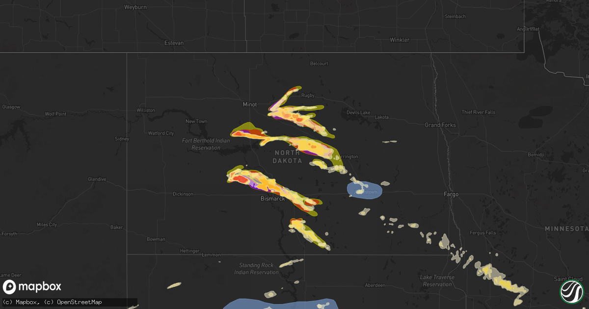
Hail Map in North Dakota on June 27, 2025
Get this storm
June 27 map
$229
one time, instant access
Download today. No call, no setup
Keep the $229
Bought the map and want the full workflow? Apply the entire $229 to a subscription within 7 days. None of it is wasted.
Every map, not just this one
This buys you this map. Subscription and you get every map we run, in the markets you choose from a few cities to whole states to nationwide. Plus real-time alerts the moment a storm fires.
Contact data
Name, contact info, occupancy, even credit band for addresses in the footprint. You go from where it hit to who to call.
Become the source they trust
Unlimited branding weather history reports on demand. You already have the documented answer ready for the property owner, and you are the one who showed up with it.
Property data and RoofTrace estimates
Pull up any address you have got, its value and the exact code rules for that jurisdiction, straight from One Click Code. Then RoofTrace estimates the squares, pitch, and roof value, priced the way you price.
Storm reports in North Dakota
North Dakota
| Date | Description |
|---|---|
| 06/27/202512:30 AM CDT | Nddot sensor. |
| 06/26/202511:46 PM CDT | Time estimated from radar. |
| 06/26/202511:12 PM CDT | A local report indicates a tornado near 6 SSW Mckenzie |
| 06/26/202511:12 PM CDT | Law enforcement relayed report of tornado on the ground. |
| 06/26/202511:06 PM CDT | (bis |
| 06/26/202511:06 PM CDT | A local report indicates a tornado near 9 SSE Driscoll |
| 06/26/202511:06 PM CDT | A local report indicates a tornado near 8 SE Driscoll |
| 06/26/202511:00 PM CDT | Delayed report of two large trees |
| 06/26/202511:00 PM CDT | Delayed report of two large trees uprooted and laying on road. Time estimated by radar. |
| 06/26/202510:45 PM CDT | Relayed through broadcast media. Time estimated from radar. |
| 06/26/202510:43 PM CDT | A local report indicates a tornado near 3 WNW Menoken |
| 06/26/202510:29 PM CDT | Second of two tornadoes north of bismarck. Video footage of tornado on ground starting at 10:29 pm with dissipation at 10:34 pm. Tornado appeared to be slowly drifting |
| 06/26/202510:25 PM CDT | A local report indicates a tornado near 6 SSW Baldwin |
| 06/26/202510:22 PM CDT | Report from icechip research project. |
| 06/26/202510:22 PM CDT | Relayed through social media. Hail the size of a billiard ball. Time estimated from radar. |
| 06/26/202510:20 PM CDT | Photo relayed via social media. |
| 06/26/202510:19 PM CDT | Second confirmed tornado from storm north of linton. Ndawn linton video shows initial rope tornado |
| 06/26/202510:19 PM CDT | Rep |
| 06/26/202510:19 PM CDT | Report from mping: hen egg+ |
| 06/26/202510:15 PM CDT | Report from mping: quarter |
| 06/26/202510:14 PM CDT | Tornado has been intermittently touching the ground and lifting. Was on the ground at the time of report. |
| 06/26/20259:16 PM CDT | Relayed through social media. Time estimated from radar. |
| 06/26/20259:15 PM CDT | Report from mping: golf ball |
| 06/26/20258:53 PM CDT | A local report indicates 2.50 inch wind near 6 SSW Orrin |
| 06/26/20258:53 PM CDT | Report relayed via broadcast media. |
| 06/26/20258:49 PM CDT | Report from mping: golf ball |
| 06/26/20258:49 PM CDT | Mixed with nickel sized hail. Relayed as photo via social media. |
| 06/26/20258:42 PM CDT | Hail up to the size of baseballs was falling at the time of the report. Only a few hailstones... But some were as large as baseballs. |
| 06/26/20258:42 PM CDT | Hail up to the size of b |
| 06/26/20258:32 PM CDT | Quarter sized hail ongoing at time of call. |
| 06/26/20258:29 PM CDT | Trained spotter reported elephant trunk with faint intermittent brief ground circulations from their view. Lasted until 8:38 pm. |
| 06/26/20258:26 PM CDT | Report from icechip research project. Largest 47 mm... Most 20 to 35 mm. Noted from left mover. |
| 06/26/20258:25 PM CDT | Report from icechip research project. Time estimated from radar and hail measured a few minutes after it fell. |
| 06/26/20258:22 PM CDT | Report from mping: half dollar |
| 06/26/20258:21 PM CDT | Report from mping: golf ball |
| 06/26/20258:15 PM CDT | Hail quarter to half dollar size was falling at the time of the report. Winds of 40 to 50 mph preceded the hail. |
| 06/26/20258:15 PM CDT | Report from icechip research project. |
| 06/26/20258:07 PM CDT | Report from mping: ping pong ball |
| 06/26/20257:56 PM CDT | Relayed through social media. Time estimated from radar. |
| 06/26/20257:52 PM CDT | Time estimated by radar. Relayed via social media. |
| 06/26/20257:45 PM CDT | A few baseball size hail... Most golf ball sized. Relayed via broadcast media. |
| 06/26/20257:43 PM CDT | Report from mping: ping pong ball |
| 06/26/20257:41 PM CDT | Trained spotter and multiple public reports of a tornado at 7:41 pm. Tornado lasted approximately 9 minutes before ending. Photos of the tornado were sent via social me |
| 06/26/20257:35 PM CDT | Photo from skyspy photos of hail approximately 3 inches in diameter. |
| 06/26/20257:34 PM CDT | Relayed via broadcast media. |
| 06/26/20257:32 PM CDT | Relayed from social media. |
| 06/26/20257:31 PM CDT | Hail lasted until 7:38 pm. Largest was the size of tennis balls. |
| 06/26/20257:27 PM CDT | Relayed through social media. Largest hailstone was 3 inches in diameter. Also noted tree limbs down... A broken window... And lots of denting to shop and barn. |
| 06/26/20257:25 PM CDT | A local report indicates 1.75 inch wind near 10 W Hannover |
| 06/26/20257:20 PM CDT | Photo relayed via social media. |
| 06/26/20257:19 PM CDT | Hail... Mostly golf ball sized but some to tennis ball sized... Began at 7:19 pm and lasted until 7:34 pm. |
All States Impacted by Hail Map on June 27, 2025
Cities Impacted by Hail Map on June 27, 2025
- Opheim, MT
- Richland, MT
- Larslan, MT
- Scobey, MT
- Flaxville, MT
- Lemmon, SD
- Keldron, SD
- White River, SD
- Florence, AL
- Killen, AL
- Waynesboro, TN
- Collinwood, TN
- Summertown, TN
- Lexington, AL
- Loretto, TN
- Lawrenceburg, TN
- Iron City, TN
- Cypress Inn, TN
- Cleveland, OH
- Mount Pleasant, TN
- Euclid, OH
- Columbia, TN
- Town Creek, AL
- Hampshire, TN
- Lake Worth, FL
- Bloomingdale, MI
- Bangor, MI
- Granite City, IL
- Rogersville, AL
- Vero Beach, FL
- Spring Hill, TN
- Paw Paw, MI
- Bath Springs, TN
- Scotts Hill, TN
- Campbellsville, KY
- Gobles, MI
- Miami, OK
- Fairland, OK
- Pulaski, TN
- Thompsons Station, TN
- Franklin, TN
- Cornersville, TN
- Horse Cave, KY
- Hardyville, KY
- Lawrence, MI
- Decaturville, TN
- Fort Pierce, FL
- Elkmont, AL
- Prospect, TN
- Laurel Springs, NC
- Center, KY
- Edmonton, KY
- Munfordville, KY
- Ardmore, AL
- Hillsboro, AL
- Ardmore, TN
- Shelbyville, MI
- Wayland, MI
- Middleville, MI
- Decatur, AL
- Mattoon, IL
- Trilla, IL
- Lerna, IL
- Charleston, IL
- Winfield, TN
- Greensburg, KY
- Toney, AL
- Petersburg, TN
- Nolensville, TN
- Vossburg, MS
- Shubuta, MS
- Fayetteville, TN
- Strunk, KY
- Jamestown, TN
- Canmer, KY
- Afton, OK
- Welch, OK
- Bluejacket, OK
- Murfreesboro, TN
- Meridian, MS
- Huntsville, AL
- Richton, MS
- Great Falls, MT
- Floweree, MT
- Bradyville, TN
- Wellborn, FL
- Golden Eagle, IL
- Brussels, IL
- Lake City, FL
- Live Oak, FL
- Mount Morris, NY
- Konawa, OK
- Sasakwa, OK
- Scottsville, KY
- Patrick, SC
- Wichita Falls, TX
- Readyville, TN
- Youngstown, OH
- Geneseo, NY
- Tellico Plains, TN
- Seymour, TX
- Somerset, KY
- Byers, TX
- Belvidere, TN
- Clayton, GA
- Silver Point, TN
- Eastman, GA
- Manchester, TN
- Mount Sterling, KY
- Suches, GA
- Flat Top, WV
- Cool Ridge, WV
- Jumping Branch, WV
- Ghent, WV
- Springfield, TN
- Tomball, TX
- Bowling Green, KY
- Lake Wales, FL
- Randlett, OK
- Franklin, KY
- Stevenson, AL
- Flat Rock, AL
- Blue Ridge, GA
- Hawkinsville, GA
- Ridgedale, MO
- Omaha, AR
- Cordele, GA
- Cypress, TX
- Pisgah, AL
- Augusta, GA
- Blythe, GA
- Sapulpa, OK
- Mannford, OK
- Kellyville, OK
- Bristow, OK
- Sand Springs, OK
- Tulsa, OK
- Owingsville, KY
- Ellijay, GA
- Petrolia, TX
- Dutton, AL
- Alvaton, KY
- Sandy Hook, KY
- Olive Hill, KY
- Owasso, OK
- Catoosa, OK
- London, KY
- New Bern, NC
- Whitleyville, TN
- Gainesboro, TN
- Floral City, FL
- Higdon, AL
- Westmoreland, TN
- Portland, TN
- Woodburn, KY
- Model, CO
- Demopolis, AL
- Raccoon, KY
- Wrightsville, GA
- Bryant, AL
- Sulphur, OK
- Saint Louis, MO
- Ballwin, MO
- Arabi, GA
- Bartlesville, OK
- Delaware, OK
- Nowata, OK
- Young Harris, GA
- Adolphus, KY
- Okeechobee, FL
- Chattanooga, TN
- Pikeville, KY
- Shelbiana, KY
- Dixon, MO
- Davis, OK
- Hiawassee, GA
- Casselberry, FL
- Oviedo, FL
- Winter Springs, FL
- Sanford, FL
- Winter Park, FL
- Deltona, FL
- Osteen, FL
- Dublin, GA
- Albany, KY
- Monticello, KY
- Enfield, NC
- Whitakers, NC
- Blairsville, GA
- Brasstown, NC
- Trenton, GA
- Rising Fawn, GA
- Wildwood, GA
- West Liberty, KY
- Gordon, NE
- Bingham, NE
- Rushville, NE
- Ellsworth, NE
- Alva, WY
- Aladdin, WY
- Sundance, WY
- Signal Mountain, TN
- Holliday, TX
- Union, WV
- Knox City, TX
- East Dublin, GA
- Russellville, KY
- Red Boiling Springs, TN
- Murphy, NC
- Ashby, NE
- Beulah, WY
- Hollister, NC
- Melbourne, AR
- Maysville, OK
- Ringling, OK
- Canton, GA
- Kingston, GA
- Cumming, GA
- Morgantown, KY
- Flintstone, GA
- Lookout Mountain, GA
- Woodstock, GA
- Lexington, OK
- Noble, OK
- Norman, OK
- Buford, GA
- Cookeville, TN
- Akron, CO
- Otis, CO
- Suwanee, GA
- Duluth, GA
- Ellerbe, NC
- Cochranton, PA
- Utica, PA
- Fulton, KY
- Alpharetta, GA
- Flowery Branch, GA
- Grass Range, MT
- Winnett, MT
- Kilgore, NE
- Crookston, NE
- Trementina, NM
- Livingston, TN
- Whitwell, TN
- Felicity, OH
- Georgetown, OH
- Hamersville, OH
- Waleska, GA
- Plymouth, NC
- Greensboro, AL
- Henrietta, TX
- Atlanta, GA
- Gainesville, GA
- Oakwood, GA
- Sedalia, KY
- Dunlap, TN
- Ball Ground, GA
- Conchas Dam, NM
- Middletown, MO
- Valley Park, MO
- Aragon, GA
- Wake Forest, NC
- Raleigh, NC
- Hebron, OH
- Heath, OH
- Granville, OH
- Newark, OH
- Hixson, TN
- Rossville, GA
- Newton Grove, NC
- Dunn, NC
- Rockmart, GA
- Cedartown, GA
- Cleveland, TN
- Dalton, GA
- Clinton, NC
- Graysville, TN
- Fort Mill, SC
- Waxhaw, NC
- Presho, SD
- Crossville, TN
- Granville, ND
- Towner, ND
- Karlsruhe, ND
- Douglas, ND
- Ryder, ND
- Horse Branch, KY
- Kennebec, SD
- Scotts, MI
- Vicksburg, MI
- Dallas, GA
- Colorado Springs, CO
- Jasper, GA
- Taylorsville, GA
- Beulah, ND
- New Salem, ND
- Hazen, ND
- Reliance, SD
- Vivian, SD
- Georgetown, TN
- Dayton, TN
- Kennesaw, GA
- Marietta, GA
- Decatur, GA
- Acworth, GA
- Nathalie, VA
- Circleville, OH
- Tarboro, NC
- Eureka, MO
- Forest Park, GA
- Chatsworth, GA
- Rugby, ND
- Max, ND
- Minot, ND
- Sawyer, ND
- Garrison, ND
- Stanton, ND
- Center, ND
- Lithonia, GA
- Moss, TN
- Morrow, GA
- Stockbridge, GA
- Russellville, OH
- Ripley, OH
- Ellenwood, GA
- Voltaire, ND
- Velva, ND
- Ruso, ND
- Benedict, ND
- Anamoose, ND
- Fenton, MO
- Lafayette, TN
- Peachtree Corners, GA
- Norcross, GA
- Rex, GA
- Lupton City, TN
- Stone Mountain, GA
- Ryan, OK
- Rock Hill, SC
- Drake, ND
- Balta, ND
- Willow City, ND
- New Underwood, SD
- Sturgis, SD
- Union Center, SD
- Enning, SD
- White Owl, SD
- Faith, SD
- Owanka, SD
- Howes, SD
- Wasta, SD
- Mud Butte, SD
- Wall, SD
- Cherry Creek, SD
- Milesville, SD
- Eagle Butte, SD
- Dupree, SD
- Lantry, SD
- Esmond, ND
- Mandan, ND
- Mcdonough, GA
- Vicco, KY
- Littcarr, KY
- Hindman, KY
- Hardy, VA
- Elmore City, OK
- Balfour, ND
- Tucker, GA
- Isabel, SD
- Timber Lake, SD
- Gleason, TN
- Mallie, KY
- Pine Top, KY
- Carrie, KY
- Jonesboro, GA
- Lilburn, GA
- Skiatook, OK
- Hamill, SD
- Bismarck, ND
- Baldwin, ND
- Oacoma, SD
- Chamberlain, SD
- Gregory, SD
- Winner, SD
- Platte, SD
- Burke, SD
- White Lake, SD
- Kimball, SD
- Pukwana, SD
- Dunning, NE
- Butte, ND
- Ideal, SD
- Moneta, VA
- Williamsport, OH
- Macomb, OK
- Goodview, VA
- Meta, MO
- Argyle, MO
- Harvey, ND
- York, ND
- Ridgeview, SD
- Saint Francis, SD
- Mission, SD
- Turtle Lake, ND
- Menoken, ND
- Clarkson, KY
- Tuscaloosa, AL
- Northport, AL
- Lone Grove, OK
- Ardmore, OK
- Wayne, OK
- Kim, CO
- Conyers, GA
- West Blocton, AL
- Birmingham, AL
- Brookwood, AL
- Woodstock, AL
- McCalla, AL
- Vance, AL
- Moundville, AL
- Stoutsville, OH
- Fort Myers, FL
- Geddes, SD
- Harrison, SD
- Stickney, SD
- Plankinton, SD
- Corsica, SD
- New Holland, SD
- Armour, SD
- Adair, OK
- Big Cabin, OK
- Wilton, ND
- Hartsville, SC
- Tecumseh, OK
- Fort Pierre, SD
- Onida, SD
- Agar, SD
- Pierre, SD
- Gettysburg, SD
- Linton, ND
- Mcclusky, ND
- Martin, ND
- Denhoff, ND
- Maddock, ND
- Lebanon, SD
- Hoven, SD
- Harrold, SD
- Mount Vernon, SD
- Mitchell, SD
- Lake Andes, SD
- Ethan, SD
- Parkston, SD
- Delmont, SD
- Dimock, SD
- Riverdale, GA
- Gallion, AL
- Benton, KY
- Florence, MS
- Goodrich, ND
- Sterling, ND
- Driscoll, ND
- Fessenden, ND
- Tolstoy, SD
- Onaka, SD
- Bowdle, SD
- Holabird, SD
- Highmore, SD
- Seneca, SD
- Tripp, SD
- Alexandria, SD
- Fulton, SD
- Wagner, SD
- Avon, SD
- Olivet, SD
- Franklinton, LA
- Byram, MS
- Terry, MS
- Lewistown, MT
- Hardin, KY
- Jackson, MS
- Hazelton, ND
- Steele, ND
- Hurdsfield, ND
- Chaseley, ND
- Cathay, ND
- New Rockford, ND
- Sheyenne, ND
- Prairie City, SD
- Reva, SD
- Charleston, TN
- Calhoun, TN
- Amanda, OH
- Auburn, KY
- Springville, AL
- Jackson, KY
- Odenville, AL
- Idalia, CO
- Nashville, GA
- Alapaha, GA
- Piketon, OH
- Burlington, CO
- Kirk, CO
- Shawnee, OK
- Willacoochee, GA
- Mcloud, OK
- Bowdon, ND
- Tippecanoe, OH
- Lenox, GA
- Crawfordville, GA
- Homer, GA
- Taylorsville, NC
- Tarlton, OH
- Laurelville, OH
- Monroe, LA
- Sykeston, ND
- Providence, KY
- Boomer, NC
- Gunlock, KY
- Lincoln, AL
- Pell City, AL
- Riverside, AL
- Cromwell, KY
- Pantego, NC
- Bastrop, LA
- Kanorado, KS
- Ashville, AL
- Clinton, TN
- Rocky Face, GA
- Springfield, SD
- Tyndall, SD
- Scotland, SD
- Dante, SD
- Kaylor, SD
- Freeman, SD
- Bridgewater, SD
- Canistota, SD
- Marion, SD
- Spencer, SD
- Menno, SD
- Emery, SD
- Lower Brule, SD
- Fort Thompson, SD
- Blunt, SD
- Miller, SD
- Stephan, SD
- Faulkton, SD
- Orient, SD
- Goodland, KS
- Edson, KS
- Brewster, KS
- Carrington, ND
- Woodworth, ND
- Braddock, ND
- Dawson, ND
- Glenham, SD
- Talladega, AL
- Ashburn, GA
- Sycamore, GA
- Hayes, SD
- Whitehorse, SD
- Colby, KS
- Levant, KS
- Ree Heights, SD
- Gann Valley, SD
- Niobrara, NE
- Tabor, SD
- Lesterville, SD
- Bloomfield, NE
- Crofton, NE
- Yankton, SD
- Utica, SD
- Parker, SD
- Irene, SD
- Viborg, SD
- Monroe, SD
- Hurley, SD
- Jamestown, ND
- Musella, GA
- Bogalusa, LA
- Merriman, NE
- Ragland, AL
- Snellville, GA
- Cedar Bluff, VA
- Rebecca, GA
- Pataskala, OH
- Wessington Springs, SD
- Wessington, SD
- Saint Lawrence, SD
- Alpena, SD
- Virgil, SD
- Volin, SD
- Saint Helena, NE
- Wakonda, SD
- Gayville, SD
- Hartington, NE
- Wynot, NE
- Chancellor, SD
- Mission Hill, SD
- Lennox, SD
- Centerville, SD
- Davis, SD
- Vermillion, SD
- Beresford, SD
- Fordyce, NE
- Hague, ND
- Buchanan, ND
- Pingree, ND
- Purdum, NE
- Cartersville, GA
- Moffit, ND
- Kintyre, ND
- Tappen, ND
- Napoleon, ND
- Selby, SD
- Wishek, ND
- Colton, SD
- Lynn, AL
- Emmalena, KY
- Marion, KY
- Robinson, ND
- Lenoir, NC
- Beaver Dam, KY
- Sanborn, ND
- Van Buren, MO
- Olaton, KY
- Chester, SD
- Delta, AL
- Doniphan, MO
- Gatewood, MO
- Lineville, AL
- Lisbon, ND
- Rogers, ND
- Verona, ND
- Oakes, ND
- Lamoure, ND
- Marion, ND
- Dickey, ND
- Pettibone, ND
- Egan, SD
- Reynolds, GA
- Montpelier, ND
- Roseboro, NC
- Conley, GA
- Toronto, OH
- Jud, ND
- Salemburg, NC
- Zeeland, ND
- Flandreau, SD
- Wallace, KS
- Steubenville, OH
- Weirton, WV
- Centreville, AL
- Brierfield, AL
- Collettsville, NC
- Tuttle, ND
- Woodbury, TN
- Cleveland, ND
- Wimbledon, ND
- Spiritwood, ND
- Ypsilanti, ND
- Las Vegas, NM
- Milnor, ND
- Winona, KS
- Litchville, ND
- South Bloomingville, OH
- Cayuga, ND
- Ashley, ND
- Fort Ransom, ND
- Wyndmere, ND
- Lidgerwood, ND
- Hankinson, ND
- Brewster, NE
- Whitesburg, KY
- Mantador, ND
- Adger, AL
- Creedmoor, NC
- Rosholt, SD
- Draper, SD
- Fairmount, ND
- Wheaton, MN
- Sargent, NE
- Barney, ND
- Mooreton, ND
- Yeaddiss, KY
- Cottonwood, MN
- Aneta, ND
- Binford, ND
- Taylor, NE
- Hanley Falls, MN
- Vesta, MN
- Wood Lake, MN
- Stratton, CO
- Tintah, MN
- Norcross, MN
- Freeport, OH
- Campbell, MN
- Oakley, KS
- Berry, AL
- Milroy, MN
- Bethune, CO
- Walnut Grove, MN
- Lucan, MN
- Morris, MN
- Donnelly, MN
- Chokio, MN
- Herman, MN
- Windom, MN
- Jeffers, MN
- Wabasso, MN
- Hancock, MN
- Le Mars, IA
- Bingham Lake, MN
- Wakpala, SD
- Thaxton, VA
- Vinton, VA
- Cyrus, MN
- Springfield, MN
- Sanborn, MN
- Merrill, IA
- Burwell, NE
- Starbuck, MN
- Heron Lake, MN
- Alberta, MN
- Hinton, IA
- Mountain Lake, MN
- Valentine, NE
- Kingsley, IA
- Benson, MN
- Glenwood, MN
- Kerkhoven, MN
- Pennock, MN
- Deane, KY
- Murdock, MN
- Knobel, AR
- Hoffman, MN
- Comfrey, MN
- Butterfield, MN
- Evansville, MN
- Barrett, MN
- Pollock, SD
- Boise City, OK
- Clontarf, MN
- Trimont, MN
- Odin, MN
- Sunburg, MN
- Saint Francis, KS
- Saint James, MN
- Brooten, MN
- New London, MN
- Belgrade, MN
- Moville, IA
- Wray, CO
- Gruver, TX
- Herreid, SD
- Walsh, CO
- Elbow Lake, MN
- Vincent, AL
- Cropwell, AL
- Alpine, AL
- Ormsby, MN
- Truman, MN
- Sioux City, IA
- Lawton, IA
- Carbon Hill, AL
- Haleyville, AL
- Honaker, VA
- Belle Fourche, SD
- Swords Creek, VA
- Raven, VA
- Oakwood, VA
- Richmond, OH
- Walker, WV
- Follansbee, WV
- Anthon, IA
- Correctionville, IA
- Blue Earth, MN
- Elmore, MN
- Colliers, WV
- Mingo Junction, OH
- Thedford, NE
- Clare, IA
- Eastlake, OH
- Wickliffe, OH
- Buffalo, MN
- Delano, MN
- Temple, OK
- Rockford, MN
- Ridgeway, SC
- Sharon Springs, KS
- Milaca, MN
- Hitchcock, SD
- Mora, MN
- Isle, MN
- Brook Park, MN
- Hinckley, MN
- Sandstone, MN
- Pine City, MN
- Grasston, MN
- Carpenter, SD
- Pinetown, NC
- Elk Point, SD
- Huron, SD
- Trent, SD
- Yale, SD
- Willow Lake, SD
- Jefferson, SD
- Westfield, IA
- Iroquois, SD
- Monument, KS
- Montezuma, GA
- Oglethorpe, GA
- Brookings, SD
- De Smet, SD
- Bryant, SD
- Erwin, SD
- Volga, SD
- Lake Preston, SD
- Arlington, SD
- Bruce, SD
- Wolsey, SD
- Emerson, GA
- Soddy Daisy, TN
- Washburn, ND


