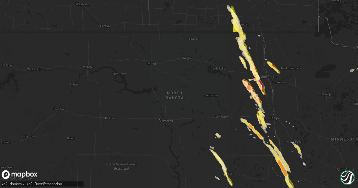
Hail Map in North Dakota on June 27, 2015
Get this storm
June 27 map
$229
one time, instant access
Download today. No call, no setup
Keep the $229
Bought the map and want the full workflow? Apply the entire $229 to a subscription within 7 days. None of it is wasted.
Every map, not just this one
This buys you this map. Subscription and you get every map we run, in the markets you choose from a few cities to whole states to nationwide. Plus real-time alerts the moment a storm fires.
Contact data
Name, contact info, occupancy, even credit band for addresses in the footprint. You go from where it hit to who to call.
Become the source they trust
Unlimited branding weather history reports on demand. You already have the documented answer ready for the property owner, and you are the one who showed up with it.
Property data and RoofTrace estimates
Pull up any address you have got, its value and the exact code rules for that jurisdiction, straight from One Click Code. Then RoofTrace estimates the squares, pitch, and roof value, priced the way you price.
Storm reports in North Dakota
North Dakota
| Date | Description |
|---|---|
| 06/27/20156:58 PM CDT | A local report indicates 1.75 inch wind near 2 SW WHEATLAND |
| 06/27/20156:55 PM CDT | A local report indicates 1.75 inch wind near 2 SW WHEATLAND |
| 06/27/20156:30 PM CDT | Numerous large tree branches were broken down around town. |
| 06/27/20156:28 PM CDT | Quarter to golf ball size hail reported by multiple spotters in mcleod. |
| 06/27/20156:15 PM CDT | Quarter size hail currently falling at intersection of county road 15 and 13 in grand forks county. |
| 06/27/20156:13 PM CDT | Spotter previously had reported this as a funnel cloud. A damage survey found that the tornado tracked roughly southward for around miles to near 6 wsw of galesburg by |
| 06/27/20156:10 PM CDT | A local report indicates 1.75 inch wind near HOLMES |
| 06/27/20156:08 PM CDT | Debris indicated on radar. Spotter reports funnel as viewed from hatton... But cant see the ground area. |
| 06/27/20156:05 PM CDT | A local report indicates 1.00 inch wind near 2 SSW SHELDON |
| 06/27/20156:02 PM CDT | Debris indicated on radar. Spotters reported funnel as viewed from hatton and from holmes. The tornado tracked south southeast for nearly 3 miles and lifted by 615 pm c |
| 06/27/20156:01 PM CDT | Debris indicated on radar. Spotter reported funnel as viewed from hatton... But couldnt see the ground area. Thetronado tracked for a mile or 2 to the south and lifted |
| 06/27/20156:00 PM CDT | Large hail and strong winds produced widespread rooftop and crop damage in the clifford area. |
| 06/27/20155:58 PM CDT | A local report indicates a tornado near 9 NE HOPE |
| 06/27/20155:48 PM CDT | This tornado tracked for over 3 miles to the south southeast and lifted around 6 miles ene of hope by 558 pm cdt. The torando damaged numerous trees in shelter benlts a |
| 06/27/20155:44 PM CDT | A local report indicates 1.75 inch wind near 3 ENE ARVILLA |
| 06/27/20155:44 PM CDT | Large hail fell over a period of about 6 minutes... Through 550 pm cdt. Pictures and reports posted via social media. |
| 06/27/20155:42 PM CDT | Multiple reports of tornado as viewed from larilore and emerado. |
| 06/27/20155:42 PM CDT | Large swath of quarter to hen egg sized hail fell across portions of edendale township through 550 pm cdt. |
| 06/27/20155:38 PM CDT | A tornado tracked for roughly 2 miles to about 1 ssw of arvilla by 542 pm cdt. The funnel cloud was visible for several more minutes and was viewed and photographed fro |
| 06/27/20155:38 PM CDT | A tornado tracked for roughly 2 miles to about 1 s of arvilla by 542 pm cdt. The funnel cloud was visible for several more minutes and was viewed and photographed from |
| 06/27/20155:38 PM CDT | Touchdown reported in 3400 block west of arvilla. |
| 06/27/20155:37 PM CDT | A local report indicates 3.00 inch wind near 3 N NORTHWOOD |
| 06/27/20155:35 PM CDT | A local report indicates 1.75 inch wind near ARVILLA |
| 06/27/20155:31 PM CDT | A local report indicates 1.75 inch wind near GRAND FORKS AFB |
| 06/27/20155:26 PM CDT | A local report indicates 1.00 inch wind near GRAND FORKS AFB |
| 06/27/20155:25 PM CDT | Very large hail across northwest side of golden lake. Also some 2 inch branches broken down. |
| 06/27/20155:24 PM CDT | Brief touchdown viewed from near cuba. |
| 06/27/20155:24 PM CDT | Brief touchdown in open field as viewed from near cuba. |
| 06/27/20155:18 PM CDT | A local report indicates a tornado near 4 ESE SHARON |
| 06/27/20155:18 PM CDT | Brief touchdown noted in open field. |
| 06/27/20155:15 PM CDT | Tornado viewed south of hwy 15 moving east. |
| 06/27/20155:13 PM CDT | Tornado viewed south of hwy 15 moving east. Tornado lasted for about two minutes...until 515 pm cdt...and travelled nearly a mile over open fields. |
| 06/27/20155:08 PM CDT | Debris indocated on radar. Spotter reports funnel as viewed from hatton... But cant see the ground area. |
| 06/27/20155:05 PM CDT | Hail up to hen egg sized fell for several minutes across wheatfield township. |
| 06/27/20155:00 PM CDT | A local report indicates 1.75 inch wind near 1 S LANKIN |
| 06/27/20154:55 PM CDT | This tornado tracked intermittently for around 6 miles and lasting through 510 pm cdt. It touched down along the east edge of the forest river colony and passed just we |
| 06/27/20154:47 PM CDT | Time estimated by radar. Spotter found ping pong ball sized hail 45 minutes after it fell. |
| 06/27/20154:46 PM CDT | A local report indicates 1.75 inch wind near 1 S LANKIN |
| 06/27/20154:45 PM CDT | A local report indicates 1.75 inch wind near 1 S LANKIN |
| 06/27/20154:45 PM CDT | Large hail and brief heavy rain preceded the arrival of a weak tornado. |
| 06/27/20154:36 PM CDT | This tornado developed well behind the rain and hail of a rapidly intensifying thunderstorm. It tracked eastward intermittently for 4.8 miles to about 10 nne of aneta b |
| 06/27/20154:35 PM CDT | Tornado viewed and reported from grand forks airport /kgfk/... Roughly 18 miles to the nw of that location. |
| 06/27/20154:32 PM CDT | Tornado still viewed from hwy 32 and from gilby area ...till about 435pm cdt. Tornado tracked just southwest of inkster...headed southeast. |
| 06/27/20154:28 PM CDT | Tornado viewed from multiple locations...two minute touchdown along a roughly mile long track over open fields east of fordville. Maximum width estimated to 50 yards. P |
| 06/27/20154:28 PM CDT | Tornado still viewed from hwy 32 and from gilby area ...till about 435pm cdt. Tornado tracked just southwest of inkster...headed southeast. |
| 06/27/20154:24 PM CDT | New tornado viewed. Possible structure hit. |
| 06/27/20154:24 PM CDT | This tornado was viewed from near adams as it tracked for maybe a mile across a shelter belt and along the edge of a farmstead. A few large branches were broken down an |
| 06/27/20154:17 PM CDT | Multiple tornado votices viewed from adams. |
| 06/27/20154:17 PM CDT | This tornado tracked for at least 3 miles across mainly open fields to around 5 west of park river by 428 pm cdt. This tornado varying red and black dirt plume and was |
| 06/27/20154:12 PM CDT | This tornado was viewed by trained spotters from near edinburg and near adams. This tornado tracked from roughly one half mile nnw of union... Through union and to at l |
| 06/27/20154:12 PM CDT | Brief spinup along ridge between adams and edinburg. |
| 06/27/20154:09 PM CDT | This tornado was viewed by trained spotters from near edinburg and near adams. This tornado tracked from roughly 2 nnw of union... Through union and to at least 1 mile |
| 06/27/20154:02 PM CDT | Brief touchdown as viewed looking west northwest from gardar and east southeast from osnabrock by trained spotters. Tornado tracked southeastward for nearly one mile ac |
| 06/27/20154:02 PM CDT | Brief touchdown noted. |
| 06/27/20154:00 PM CDT | Nickel to quarter sized hail fell for several minutes in the town of concrete and at the nearby cavalier air force station. |
| 06/27/20153:55 PM CDT | A rope tornado touched for less than a minute in open fields east of town. Peak winds estimated to 70 mph. Peak width estimated to 20 yards. Track length to one quarter |
| 06/27/20153:42 PM CDT | Quarter to half dollar sized hail fell for several minutes. |
| 06/26/20159:00 PM CDT | Large hail up to ping pong balls in size and very heavy rain hail fell for several minutes across eastern devillo township. |
| 06/26/20158:59 PM CDT | Large tornado was viewed by trained spotters and storm chasers as it crossed hwy 11. The tornado touched down and quickly became enshrouded in heavy rain and hail but a |
| 06/26/20158:59 PM CDT | Large tornado viewed by chaser. |
| 06/26/20158:44 PM CDT | Tornado was initially reported as possibly two funnel clouds under the same wall cloud by a trained spotter. The tornado touched down and tracked for less than a mile a |
| 06/26/20158:22 PM CDT | A tornado touched down near barney and tracked south southeast from a mile or two by 826 pm cdt. The tornado broke down large trees and numerous large tree branches. It |
| 06/26/20158:20 PM CDT | A local report indicates 1.50 inch wind near MOORETON |
| 06/26/20157:35 PM CDT | Grain bins blown down. Location and time are approximated. |
| 06/26/20157:20 PM CDT | Strong winds and large hail impacted southern maple river township for several minutes. |
| 06/26/20157:00 PM CDT | A local report indicates 1.00 inch wind near CASSELTON |
All States Impacted by Hail Map on June 27, 2015
Cities Impacted by Hail Map on June 27, 2015
- Walhalla, ND
- Currie, MN
- Westbrook, MN
- Walnut Grove, MN
- Reynolds, ND
- Northwood, ND
- Hatton, ND
- Mayville, ND
- Dumont, MN
- Arvilla, ND
- Emerado, ND
- Larimore, ND
- Cubero, NM
- Dulce, NM
- Walcott, ND
- Sharon, ND
- Gallina, NM
- Jemez Springs, NM
- Adams, ND
- Lankin, ND
- Fordville, ND
- Wheaton, MN
- Graceville, MN
- Farwell, MN
- Starbuck, MN
- Kensington, MN
- Kearny, AZ
- Ramseur, NC
- Mekinock, ND
- Forest River, ND
- Grand Forks Afb, ND
- Gilby, ND
- Inkster, ND
- Placitas, NM
- Show Low, AZ
- Thompson, ND
- Chokio, MN
- Mora, NM
- Saint Matthews, SC
- Cameron, SC
- San Ysidro, NM
- Jemez Pueblo, NM
- Westport, SD
- Leola, SD
- Madison, MN
- Odessa, MN
- Fairmount, ND
- Hankinson, ND
- Bellingham, MN
- Wahpeton, ND
- Tintah, MN
- Ortonville, MN
- Lidgerwood, ND
- Rosholt, SD
- Mantador, ND
- Wyndmere, ND
- Clinton, MN
- Mooreton, ND
- Cummings, ND
- Katy, TX
- Enderlin, ND
- Wolsey, SD
- Alpena, SD
- Huron, SD
- Tracy, MN
- Catarina, TX
- Asherton, TX
- Milton, ND
- Langdon, ND
- Park River, ND
- Grafton, ND
- Pisek, ND
- Cavalier, ND
- Hoople, ND
- Edinburg, ND
- Mountain, ND
- Osnabrock, ND
- Hawley, MN
- Fort Pierre, SD
- Galesburg, ND
- Hunter, ND
- Hoffman, NC
- Pinebluff, NC
- Oracle, AZ
- Kindred, ND
- Sanford, NC
- Pembina, ND
- Bathgate, ND
- Sapello, NM
- Las Vegas, NM
- Rociada, NM
- Vallecitos, NM
- Mcleod, ND
- Lisbon, ND
- Sheldon, ND
- Valley City, ND
- Milnor, ND
- Fingal, ND
- Nome, ND
- Bear Creek, NC
- Siler City, NC
- Ipswich, SD
- Mapleton, ND
- Eagle Butte, SD
- Warren, MN
- Fairmont, NC
- Aberdeen, SD
- Fredonia, ND
- Brentford, SD
- Mansfield, SD
- Mellette, SD
- Frederick, SD
- Ashley, ND
- Warner, SD
- Forbes, ND
- Hitchcock, SD
- Axton, VA
- Alvarado, MN
- Euclid, MN
- Medina, TX
- Finley, ND
- Martinsville, VA
- Bernalillo, NM
- Hillsboro, ND
- Clifford, ND
- Jud, ND
- Kulm, ND
- Edgeley, ND
- Pelican Rapids, MN
- Ribera, NM
- Youngsville, LA
- Lafayette, LA
- Minneota, MN
- Boyd, MN
- Barry, MN
- Correll, MN
- Barney, ND
- Oriska, ND
- Dawson, MN
- Hope, ND
- Uvalde, TX
- Gibsonville, NC
- Browns Summit, NC
- Reidsville, NC
- Leonard, ND
- Cotulla, TX
- Wheatland, ND
- Thomaston, GA
- Riviera, TX
- Holloway, MN
- Canby, MN
- Campbell, MN
- Sisseton, SD
- Reserve, NM
- Globe, AZ
- Culloden, GA
- Musella, GA
- Mitchell, SD
- Ethan, SD
- Mount Vernon, SD
- Laredo, TX
- Macon, GA
- Dry Branch, GA
- Aneta, ND
- Casselton, ND
- Amenia, ND
- Davenport, ND
- Letcher, SD
- Woonsocket, SD
- Redfield, SD
- Dimock, SD
- Tulare, SD
- Reno, NV
- Cleveland, NM
- Cuba, NM
- Dalton, MN
- Elbow Lake, MN
- Ashby, MN
- Wedowee, AL
- Lineville, AL
- Portland, ND
- Fergus Falls, MN
- Shorterville, AL
- Clemmons, NC
- Advance, NC
- Yatesville, GA
- Troy, SC
- Houston, TX
- Tijeras, NM
- Mocksville, NC
- Cedar Crest, NM
- Leakey, TX
- Rio Frio, TX
- Cresbard, SD
- Port Saint Lucie, FL
- Durango, CO
- Big Falls, MN
- Eagar, AZ
- Glorieta, NM
- Sumter, SC
- Dalzell, SC
- Humble, TX
- Erie, ND
- Litchville, ND
- Rowland, NC
- Lumberton, NC
- Hoffman, MN
- Barrett, MN
- Evansville, MN
- Algodones, NM
- White Castle, LA
- Goliad, TX
- Pie Town, NM
- Pecos, NM
- Arthur, ND
- Roanoke, AL
- Jay, FL
- Cottonwood, MN
- Hanley Falls, MN
- Clarkfield, MN
- Montezuma, NM
- Tererro, NM
- Horace, ND
- Marana, AZ
- Clewiston, FL
- Wadley, AL
- Colfax, ND
- Union Springs, AL
- Abbeville, AL
- Ridgeway, VA
- Franklin, GA
- Buena Vista, CO
- Niagara, ND
- Molena, GA
- Big Wells, TX
- Crystal, ND
- Argyle, MN
- Winston Salem, NC
- Lexington, NC
- Scott, LA
- Monte Vista, CO
- Sandia Park, NM
- Darlington, SC
- Brenham, TX
- Newville, AL
- Headland, AL
- Blanchard, ND
- Argusville, ND
- Tierra Amarilla, NM
- Schulenburg, TX
- Freeport, TX
- Ashland, AL
- Ocate, NM
- Collinsville, VA
- Canal Point, FL
- Tomball, TX
- Stratford, SD
- Appleton, MN
- Fieldale, VA
- Ponderosa, NM
- Buxton, ND
- Hensel, ND
- Absaraka, ND
- Ayr, ND


