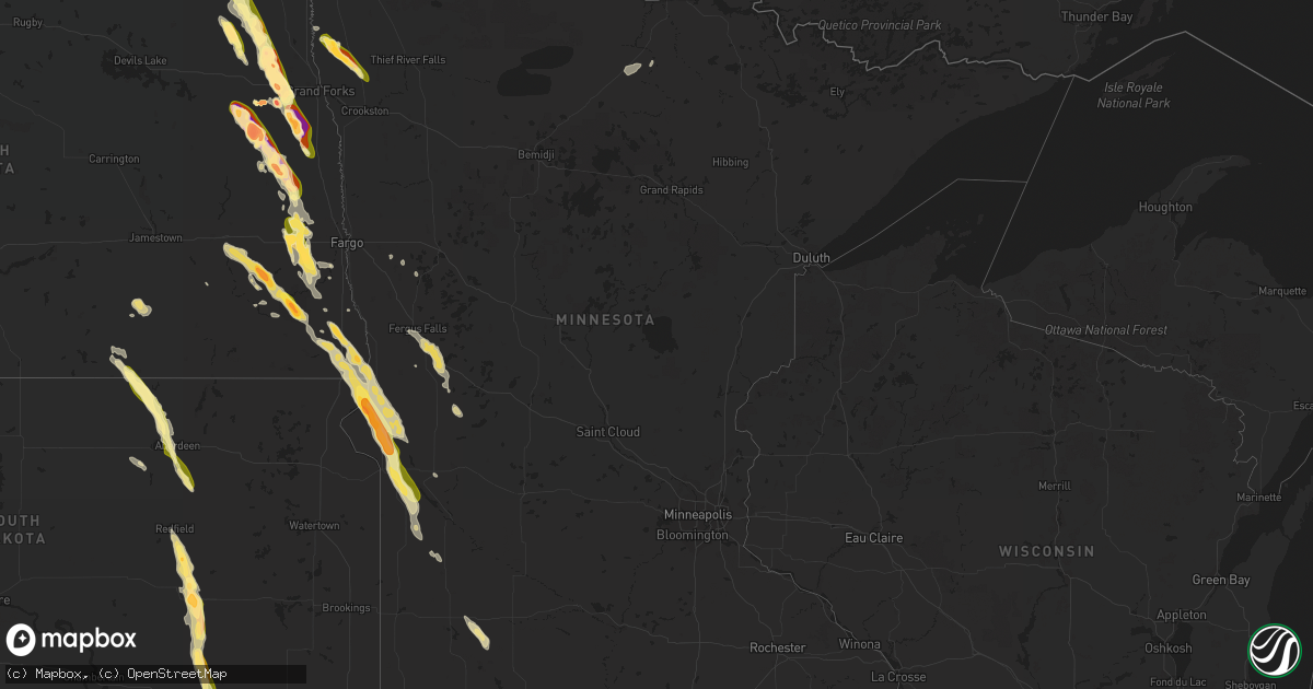
Hail Map in Minnesota on June 27, 2015
Get this storm
June 27 map
$229
one time, instant access
Download today. No call, no setup
Keep the $229
Bought the map and want the full workflow? Apply the entire $229 to a subscription within 7 days. None of it is wasted.
Every map, not just this one
This buys you this map. Subscription and you get every map we run, in the markets you choose from a few cities to whole states to nationwide. Plus real-time alerts the moment a storm fires.
Contact data
Name, contact info, occupancy, even credit band for addresses in the footprint. You go from where it hit to who to call.
Become the source they trust
Unlimited branding weather history reports on demand. You already have the documented answer ready for the property owner, and you are the one who showed up with it.
Property data and RoofTrace estimates
Pull up any address you have got, its value and the exact code rules for that jurisdiction, straight from One Click Code. Then RoofTrace estimates the squares, pitch, and roof value, priced the way you price.
Storm reports in Minnesota
Minnesota
| Date | Description |
|---|---|
| 06/27/20156:50 PM CDT | A local report indicates 1.00 inch wind near 2 NE EUCLID |
| 06/27/20156:37 PM CDT | Hail covered the ground. |
| 06/27/20156:11 PM CDT | Relayed via social media |
| 06/27/201511:05 AM CDT | Trees blown over in town...damage to road billboard sign. |
| 06/26/201511:05 PM CDT | A local report indicates 86 MPH wind near 2 W MARSHALL |
| 06/26/201510:14 PM CDT | Rainwise mark iii on a 60 ft tower |
| 06/26/20159:58 PM CDT | Large branches blown down. |
| 06/26/20159:54 PM CDT | A local report indicates 67 MPH wind near 2 SSE MADISON |
| 06/26/20159:50 PM CDT | Small branches down in town |
| 06/26/20159:35 PM CDT | Large branches down and power out across town time estimated. |
| 06/26/20159:25 PM CDT | A local report indicates 1.00 inch wind near ODESSA |
| 06/26/20159:15 PM CDT | Large hail and very heavy rain was reported along interstate 94 between the dalton and ashby exits. |
| 06/26/20158:41 PM CDT | A local report indicates 1.50 inch wind near 2 NW GRACEVILLE |
| 06/26/20158:35 PM CDT | A local report indicates 1.50 inch wind near 12 SW WHEATON |
| 06/26/20158:25 PM CDT | Golfball hail with estimated 50 mph winds lasted 10 minutes. Ne lake traverse. |
| 06/26/20158:20 PM CDT | A local report indicates 1.50 inch wind near 7 WNW COLLIS |
| 06/26/20158:15 PM CDT | Delayed report - largest hailstones measured at 2 inches. Damage to deck and crops. |
| 06/26/20158:10 PM CDT | Funnel viewed from downer exit off interstate 29. Series of brief dust plumes noted. |
| 06/26/20158:05 PM CDT | Funnel viewed from downer exit off interstate 29. Series of brief dust plumes noted. |
| 06/26/20158:05 PM CDT | Some damage to bean and corn crops. |
All States Impacted by Hail Map on June 27, 2015
Cities Impacted by Hail Map on June 27, 2015
- Walhalla, ND
- Currie, MN
- Westbrook, MN
- Walnut Grove, MN
- Reynolds, ND
- Northwood, ND
- Hatton, ND
- Mayville, ND
- Dumont, MN
- Arvilla, ND
- Emerado, ND
- Larimore, ND
- Cubero, NM
- Dulce, NM
- Walcott, ND
- Sharon, ND
- Gallina, NM
- Jemez Springs, NM
- Adams, ND
- Lankin, ND
- Fordville, ND
- Wheaton, MN
- Graceville, MN
- Farwell, MN
- Starbuck, MN
- Kensington, MN
- Kearny, AZ
- Ramseur, NC
- Mekinock, ND
- Forest River, ND
- Grand Forks Afb, ND
- Gilby, ND
- Inkster, ND
- Placitas, NM
- Show Low, AZ
- Thompson, ND
- Chokio, MN
- Mora, NM
- Saint Matthews, SC
- Cameron, SC
- San Ysidro, NM
- Jemez Pueblo, NM
- Westport, SD
- Leola, SD
- Madison, MN
- Odessa, MN
- Fairmount, ND
- Hankinson, ND
- Bellingham, MN
- Wahpeton, ND
- Tintah, MN
- Ortonville, MN
- Lidgerwood, ND
- Rosholt, SD
- Mantador, ND
- Wyndmere, ND
- Clinton, MN
- Mooreton, ND
- Cummings, ND
- Katy, TX
- Enderlin, ND
- Wolsey, SD
- Alpena, SD
- Huron, SD
- Tracy, MN
- Catarina, TX
- Asherton, TX
- Milton, ND
- Langdon, ND
- Park River, ND
- Grafton, ND
- Pisek, ND
- Cavalier, ND
- Hoople, ND
- Edinburg, ND
- Mountain, ND
- Osnabrock, ND
- Hawley, MN
- Fort Pierre, SD
- Galesburg, ND
- Hunter, ND
- Hoffman, NC
- Pinebluff, NC
- Oracle, AZ
- Kindred, ND
- Sanford, NC
- Pembina, ND
- Bathgate, ND
- Sapello, NM
- Las Vegas, NM
- Rociada, NM
- Vallecitos, NM
- Mcleod, ND
- Lisbon, ND
- Sheldon, ND
- Valley City, ND
- Milnor, ND
- Fingal, ND
- Nome, ND
- Bear Creek, NC
- Siler City, NC
- Ipswich, SD
- Mapleton, ND
- Eagle Butte, SD
- Warren, MN
- Fairmont, NC
- Aberdeen, SD
- Fredonia, ND
- Brentford, SD
- Mansfield, SD
- Mellette, SD
- Frederick, SD
- Ashley, ND
- Warner, SD
- Forbes, ND
- Hitchcock, SD
- Axton, VA
- Alvarado, MN
- Euclid, MN
- Medina, TX
- Finley, ND
- Martinsville, VA
- Bernalillo, NM
- Hillsboro, ND
- Clifford, ND
- Jud, ND
- Kulm, ND
- Edgeley, ND
- Pelican Rapids, MN
- Ribera, NM
- Youngsville, LA
- Lafayette, LA
- Minneota, MN
- Boyd, MN
- Barry, MN
- Correll, MN
- Barney, ND
- Oriska, ND
- Dawson, MN
- Hope, ND
- Uvalde, TX
- Gibsonville, NC
- Browns Summit, NC
- Reidsville, NC
- Leonard, ND
- Cotulla, TX
- Wheatland, ND
- Thomaston, GA
- Riviera, TX
- Holloway, MN
- Canby, MN
- Campbell, MN
- Sisseton, SD
- Reserve, NM
- Globe, AZ
- Culloden, GA
- Musella, GA
- Mitchell, SD
- Ethan, SD
- Mount Vernon, SD
- Laredo, TX
- Macon, GA
- Dry Branch, GA
- Aneta, ND
- Casselton, ND
- Amenia, ND
- Davenport, ND
- Letcher, SD
- Woonsocket, SD
- Redfield, SD
- Dimock, SD
- Tulare, SD
- Reno, NV
- Cleveland, NM
- Cuba, NM
- Dalton, MN
- Elbow Lake, MN
- Ashby, MN
- Wedowee, AL
- Lineville, AL
- Portland, ND
- Fergus Falls, MN
- Shorterville, AL
- Clemmons, NC
- Advance, NC
- Yatesville, GA
- Troy, SC
- Houston, TX
- Tijeras, NM
- Mocksville, NC
- Cedar Crest, NM
- Leakey, TX
- Rio Frio, TX
- Cresbard, SD
- Port Saint Lucie, FL
- Durango, CO
- Big Falls, MN
- Eagar, AZ
- Glorieta, NM
- Sumter, SC
- Dalzell, SC
- Humble, TX
- Erie, ND
- Litchville, ND
- Rowland, NC
- Lumberton, NC
- Hoffman, MN
- Barrett, MN
- Evansville, MN
- Algodones, NM
- White Castle, LA
- Goliad, TX
- Pie Town, NM
- Pecos, NM
- Arthur, ND
- Roanoke, AL
- Jay, FL
- Cottonwood, MN
- Hanley Falls, MN
- Clarkfield, MN
- Montezuma, NM
- Tererro, NM
- Horace, ND
- Marana, AZ
- Clewiston, FL
- Wadley, AL
- Colfax, ND
- Union Springs, AL
- Abbeville, AL
- Ridgeway, VA
- Franklin, GA
- Buena Vista, CO
- Niagara, ND
- Molena, GA
- Big Wells, TX
- Crystal, ND
- Argyle, MN
- Winston Salem, NC
- Lexington, NC
- Scott, LA
- Monte Vista, CO
- Sandia Park, NM
- Darlington, SC
- Brenham, TX
- Newville, AL
- Headland, AL
- Blanchard, ND
- Argusville, ND
- Tierra Amarilla, NM
- Schulenburg, TX
- Freeport, TX
- Ashland, AL
- Ocate, NM
- Collinsville, VA
- Canal Point, FL
- Tomball, TX
- Stratford, SD
- Appleton, MN
- Fieldale, VA
- Ponderosa, NM
- Buxton, ND
- Hensel, ND
- Absaraka, ND
- Ayr, ND


