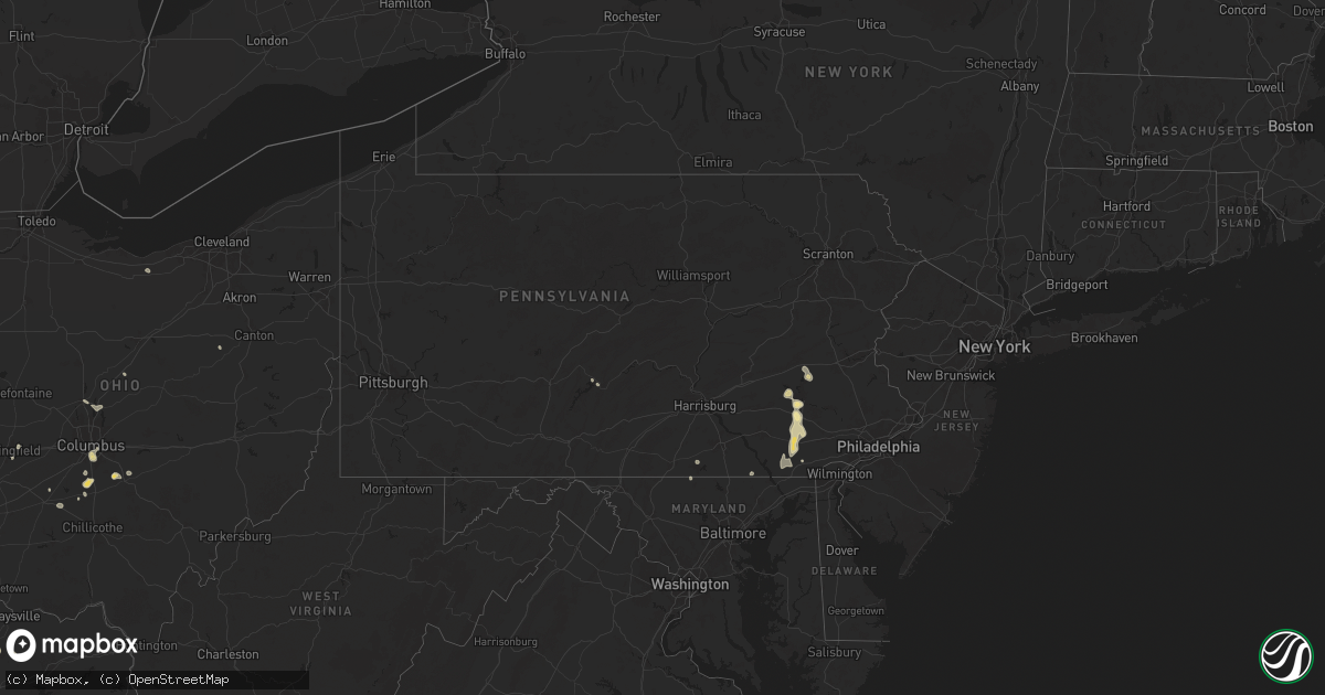
Hail Map in Pennsylvania on June 26, 2025
Get this storm
June 26 map
$229
one time, instant access
Download today. No call, no setup
Keep the $229
Bought the map and want the full workflow? Apply the entire $229 to a subscription within 7 days. None of it is wasted.
Every map, not just this one
This buys you this map. Subscription and you get every map we run, in the markets you choose from a few cities to whole states to nationwide. Plus real-time alerts the moment a storm fires.
Contact data
Name, contact info, occupancy, even credit band for addresses in the footprint. You go from where it hit to who to call.
Become the source they trust
Unlimited branding weather history reports on demand. You already have the documented answer ready for the property owner, and you are the one who showed up with it.
Property data and RoofTrace estimates
Pull up any address you have got, its value and the exact code rules for that jurisdiction, straight from One Click Code. Then RoofTrace estimates the squares, pitch, and roof value, priced the way you price.
Storm reports in Pennsylvania
Pennsylvania
| Date | Description |
|---|---|
| 06/26/20256:27 PM CDT | Trees down and blocking the roadway of s jefferson street. |
| 06/26/20256:21 PM CDT | Trees and wires down on the roadway on point road. |
| 06/26/20256:06 PM CDT | Power outages and wires down reported west of oxford. Time estimated. |
| 06/26/20255:50 PM CDT | Multiple trees and power poles snapped. Time estimated from radar. |
| 06/26/20255:47 PM CDT | Tree damage and power poles blown down. Time estimated from radar. |
| 06/26/20255:34 PM CDT | Reports of wires down along erskine road. Time estimated from radar. |
| 06/26/20255:30 PM CDT | Wires down. |
| 06/26/20255:30 PM CDT | Tree down on wires on pennsy rd near providence tw |
| 06/26/20255:30 PM CDT | Tree down on wires on pennsy rd near providence twp line. |
| 06/26/20255:25 PM CDT | Report of a tree falling on power lines causing the lines to go down and close frye avenue. Time estimated from radar. |
| 06/26/20255:20 PM CDT | 4 to 5 trees down. Time estimated via radar. |
| 06/26/20255:05 PM CDT | Tree on wires. Time estimated from radar. |
| 06/26/20255:05 PM CDT | Multiple trees and wires down across lancaster city and manor twp. |
| 06/26/20254:58 PM CDT | Reports of a tree down on power lines causing them to spark. Time estimated from radar. |
| 06/26/20254:55 PM CDT | Trees down on zion road. Time estimated from radar. |
| 06/26/20254:40 PM CDT | Trees and wires down on chapel hill road. Time estimated from radar. |
| 06/26/20254:30 PM CDT | Tree limbs down along 40th st in lawrenceville. |
| 06/26/20254:25 PM CDT | Tree down on vilsack road. Time estimated via radar. |
| 06/26/20254:19 PM CDT | Several trees down. Chicken coop blown over. |
| 06/26/20254:15 PM CDT | Tree and wires down on packing house rd near pigeon hill rd. |
| 06/26/20254:11 PM CDT | A report of wires down near the 100 block of thompson hill rd. Time estimated from radar. |
| 06/26/20254:10 PM CDT | Multiple reports of trees down across raccoon creek state park near the beach. Time estimated from radar. |
| 06/26/20254:00 PM CDT | Multiple trees snapped and uprooted. Time estimated from radar. |
| 06/26/20254:00 PM CDT | Roofing material removed from a barn. Time estimated from radar. |
| 06/26/20254:00 PM CDT | Power poles blown down. Time estimated from radar. |
| 06/26/20254:00 PM CDT | Roofing material removed from farm outbuilding. Time estimated from radar. |
| 06/26/20253:50 PM CDT | Multiple houses with roof damage and windows blown out. Time estimated from radar. |
| 06/26/20253:50 PM CDT | Multiple trees uprooted. Time estimated from radar. |
| 06/26/20253:40 PM CDT | Wires down. Time estimated from radar. |
| 06/26/20252:50 PM CDT | Tree down blocking lane on 6500 block of pa 147. |
| 06/26/20252:43 PM CDT | Wires down along bridge street. |
| 06/26/20252:38 PM CDT | Tree down on wires at east lutton street and cunningham avenue. |
| 06/26/20252:38 PM CDT | Tree down near squaw run road and ellwood road. |
| 06/26/20252:09 PM CDT | Corrects previous tstm wnd dmg report from 1 se new castle. Tree down on wires at east lutton street and cunningham avenue. |
| 06/26/20252:09 PM CDT | Wires reported down along centertown road. |
| 06/26/20251:40 PM CDT | Corrects previous flash flood report from 3 w fredonia to tstm wnd dmg. Tree down on mercer rd and partially blocking lane. |
| 06/25/20258:20 PM CDT | Trees down on wires meadow mountain drive. |
| 06/25/20258:18 PM CDT | Trees down on wires on meadow ground road. |
| 06/25/20257:39 PM CDT | Multiple trees down in the area of n clear ridge road in dublin township. |
| 06/25/20257:27 PM CDT | Trees down on wires. |
All States Impacted by Hail Map on June 26, 2025
Cities Impacted by Hail Map on June 26, 2025
- Waynesboro, TN
- Church Hill, TN
- Kingsport, TN
- Gate City, VA
- Duffield, VA
- Clayton, GA
- Tiger, GA
- Lakemont, GA
- Long Creek, SC
- Hays, NC
- Jonesville, MI
- McGrady, NC
- Washington Court House, OH
- Jerome, MI
- Clarksburg, OH
- New Holland, OH
- Springfield, OH
- Cement City, MI
- Addison, MI
- Orient, OH
- Circleville, OH
- Frankford, DE
- Selbyville, DE
- Williamsport, OH
- Albert Lea, MN
- Garner, IA
- Columbus, OH
- Bishopville, MD
- Whaleyville, MD
- Hanover, NM
- Bloomingburg, OH
- Ashville, OH
- Archbold, OH
- Wauseon, OH
- Natchez, MS
- Roxie, MS
- Thurmond, NC
- Eastanollee, GA
- Lula, GA
- Gainesville, GA
- Clermont, GA
- Amanda, OH
- Lancaster, OH
- Murrayville, GA
- Lockbourne, OH
- Groveport, OH
- Elkin, NC
- Dahlonega, GA
- Canal Winchester, OH
- Willow, OK
- Port Saint Joe, FL
- Louisville, NE
- Springfield, NE
- Williamsburg, KY
- Stinnett, TX
- Bayard, NM
- Dawsonville, GA
- Wewahitchka, FL
- Fayette, MS
- Valdosta, GA
- Delaware, OH
- Hahira, GA
- Eastpoint, FL
- Galena, OH
- Sunbury, OH
- La Farge, WI
- Hillsboro, WI
- Hamilton, OH
- Wakarusa, IN
- Goshen, IN
- Elkhart, IN
- Nappanee, IN
- Syracuse, IN
- Millersburg, IN
- New Paris, IN
- Berlin, MD
- Brookshire, TX
- Inman, SC
- Houston, TX
- Ligonier, IN
- Rochester, MN
- Elgin, MN
- Eyota, MN
- Plainview, MN
- Dover, MN
- Saint Charles, MN
- Fredericktown, OH
- Starke, FL
- Wakeman, OH
- Saint Henry, OH
- Celina, OH
- Cumming, GA
- Gotebo, OK
- Cherryville, NC
- Canton, GA
- Richmond, VA
- Quitman, GA
- Ball Ground, GA
- Alpharetta, GA
- Maria Stein, OH
- Paulding, OH
- Greenville, SC
- Travelers Rest, SC
- Taylors, SC
- Greer, SC
- Liberty, SC
- Pickens, SC
- Easley, SC
- Roswell, GA
- Columbia City, IN
- Churubusco, IN
- Monroeville, IN
- Woodburn, IN
- Farmersville, OH
- New Lebanon, OH
- Miamisburg, OH
- Germantown, OH
- Woodstock, GA
- Live Oak, FL
- Payne, OH
- Gould, OK
- Cordell, OK
- Naples, FL
- Lanesboro, MN
- Beaver, OK
- Balko, OK
- Kutztown, PA
- Hamburg, PA
- Fleetwood, PA
- Morrow, OH
- Lebanon, OH
- Atlanta, GA
- Peachtree Corners, GA
- Six Mile, SC
- Binger, OK
- Gate, OK
- Fort Cobb, OK
- Hydro, OK
- Lockhart, TX
- Henrico, VA
- Mechanicsville, VA
- Central, SC
- Carnegie, OK
- Oregonia, OH
- Oakwood, GA
- Winchester, KS
- Easton, KS
- Atchison, KS
- Leavenworth, KS
- Jasper, FL
- Sledge, MS
- Hanover, PA
- Jennings, FL
- Minco, OK
- Weston, MO
- Rushville, MO
- Norris, SC
- Ashley, MI
- Lake Park, GA
- Calumet, OK
- Louisville, KY
- De Kalb, MO
- Dearborn, MO
- Winterset, IA
- Van Meter, IA
- Prole, IA
- Waukee, IA
- Cumming, IA
- Booneville, IA
- Clive, IA
- West Des Moines, IA
- Urbandale, IA
- Windsor Heights, IA
- Adel, GA
- Sparks, GA
- Lenox, GA
- Norman Park, GA
- Faucett, MO
- Fairdale, KY
- Shubert, NE
- Yorkshire, OH
- Prestonsburg, KY
- Gracemont, OK
- Roosevelt, OK
- Marietta, GA
- Edmond, OK
- Cornelius, NC
- Agency, MO
- Gower, MO
- Buckhorn, NM
- Huntersville, NC
- Zolfo Springs, FL
- Fort Peck, MT
- Lee, FL
- Denver, NC
- Lincolnton, NC
- Maiden, NC
- Iron Station, NC
- West Union, SC
- Red Oak, GA
- Union City, OK
- El Reno, OK
- Yukon, OK
- Mustang, OK
- Nemaha, NE
- Ochopee, FL
- Greenville, FL
- Perry, FL
- Scobey, MT
- Westminster, SC
- Wolf Point, MT
- Mableton, GA
- Winona, MN
- Dakota, MN
- Trempealeau, WI
- Holmen, WI
- Chiefland, FL
- Newberry, FL
- Winter Garden, FL
- Apopka, FL
- Ocoee, FL
- Marks, MS
- Martin, GA
- Waldron, MO
- Platte City, MO
- Smithville, MO
- Kansas City, MO
- Kearney, MO
- Trimble, MO
- Edgerton, MO
- Lamesa, TX
- Ackerly, TX
- Toccoa, GA
- Westminster, MD
- Okarche, OK
- Whitetail, MT
- Nashville, GA
- Albion, IN
- Lenhartsville, PA
- Inglis, FL
- Smyrna, GA
- Coxs Creek, KY
- Seneca, SC
- Austell, GA
- Greensboro, NC
- Reading, PA
- Wernersville, PA
- Laotto, IN
- Bardstown, KY
- Arkansas City, KS
- Clermont, KY
- Shepherdsville, KY
- Coyle, OK
- Stillwater, OK
- Newkirk, OK
- Burlington Junction, MO
- Orlando, OK
- Elgin, OK
- Apache, OK
- Bloomfield, KY
- Lenexa, KS
- Overland Park, KS
- Leawood, KS
- Prairie Village, KS
- Cement, OK
- Berlin Heights, OH
- Fort Myers, FL
- Independence, MO
- Mission, KS
- Chickasha, OK
- Miami, TX
- Dale, TX
- Mohnton, PA
- Lamont, FL
- Leesport, PA
- Bernville, PA
- Vernon, TX
- Brooks, KY
- Dawson, IA
- Ninnekah, OK
- Alva, FL
- Lake City, FL
- Willisburg, KY
- Morse, TX
- Lehigh Acres, FL
- Luling, TX
- North Fort Myers, FL
- Punta Gorda, FL
- Saint Joseph, MO
- Burlington, KY
- Union, KY
- Alapaha, GA
- Pembroke, VA
- Ripplemead, VA
- Narrows, VA
- Peterstown, WV
- Iaeger, WV
- Du Bois, NE
- Narvon, PA
- Peerless, MT
- Richland, MT
- Froid, MT
- Pearisburg, VA
- Union City, GA
- Fort White, FL
- Sanford, NC
- Pylesville, MD
- White Hall, MD
- Morgantown, PA
- East Earl, PA
- Honey Brook, PA
- Rantoul, KS
- Ottawa, KS
- Gap, PA
- Aurora, IL
- Plano, IL
- Big Rock, IL
- Sugar Grove, IL
- Elburn, IL
- Maple Park, IL
- Geneva, IL
- Saint Charles, IL
- Batavia, IL
- North Aurora, IL
- Holden, WV
- Paola, KS
- Osawatomie, KS
- Humboldt, NE
- Coatesville, PA
- Atglen, PA
- New Holland, PA
- Christiana, PA
- Parkesburg, PA
- Kinzers, PA
- Pawnee City, NE
- Spring Hill, KS
- Indiahoma, OK
- Mountain Park, OK
- Corwith, IA
- Mooseheart, IL
- West Chicago, IL
- Bartlett, IL
- Elgin, IL
- Wayne, IL
- South Elgin, IL
- Wasco, IL
- Hampshire, IL
- Dundee, IL
- Gilberts, IL
- Huntley, IL
- New Hill, NC
- Boston, GA
- Moncure, NC
- Chapmanville, WV
- Stollings, WV
- Logan, WV
- Trenton, FL
- Valley Park, MS
- Aurora, IN
- Troutville, VA
- Blue Ridge, VA
- Roanoke, VA
- Quarryville, PA
- Kirkwood, PA
- Dubuque, IA
- Peosta, IA
- East Dubuque, IL
- Hazel Green, WI
- Cuba City, WI
- Kieler, WI
- Whiting, KS
- Clearmont, MO
- Pickering, MO
- Skidmore, MO
- Maryville, MO
- Floral City, FL
- Brooksville, FL
- Inverness, FL
- Louisburg, KS
- Platteville, WI
- Jamaica, IA
- Bern, KS
- Chaplin, KY
- Braman, OK
- Roundup, MT
- Apex, NC
- Thomasville, GA
- Craig, MO
- Moultrie, GA
- Monticello, FL
- Coolidge, GA
- Snyder, OK
- Anadarko, OK
- Hinton, OK
- Faxon, OK
- Lambert, MT
- Nardin, OK
- Guthrie, OK
- Briceville, TN
- Mulhall, OK
- Perry, IA
- Seneca, KS
- Brooksville, KY
- Alkol, WV
- Griffithsville, WV
- Moores Hill, IN
- Spurlockville, WV
- Lexington, KY
- Walhalla, SC
- Oneida, KS
- Clifton, VA
- Fairfax Station, VA
- Manassas, VA
- Mcdonough, GA
- Collins, OH
- Sidney, MT
- Dunkirk, MD
- Lothian, MD
- Upper Marlboro, MD
- Brandywine, MD
- Hartsfield, GA
- Locust Grove, GA
- Hampton, GA
- Harts, WV
- Ochlocknee, GA
- Rising Sun, IN
- Meigs, GA
- Larslan, MT
- Harwood, MD
- Ranger, WV
- Granger, TX
- Taylor, TX
- Stevenson, AL
- Pelham, GA
- Thaxton, VA
- Bedford, VA
- Cairo, GA
- Vicksburg, MS
- Midkiff, WV
- Kiahsville, WV
- Springer, NM
- Oxford, NC
- Bullock, NC
- Independence, KY
- Morning View, KY
- Walton, KY
- Gilman, IA
- Whigham, GA
- Sunray, TX
- Alexandria, KY
- De Mossville, KY
- Butler, KY
- Falmouth, KY
- Foster, KY
- Urbana, IN
- Mundelein, IL
- Corning, KS
- Homerville, GA
- Sewanee, TN
- Lawton, OK
- Chattanooga, OK
- Nathalie, VA
- Gretna, VA
- Java, VA
- Texico, NM
- Bovina, TX
- Dumfries, VA
- Triangle, VA
- Carlisle, KY
- Tuttle, OK
- Genoa, WV
- Wayne, WV
- Hillsboro, TN
- Latty, OH
- Goff, KS
- Soldier, KS
- Arcadia, OK
- Ewing, KY
- Williamson, WV
- Wagon Mound, NM
- Wetmore, KS
- Balmorhea, TX
- Augusta, KY
- Flemingsburg, KY
- Fort Davis, TX
- Birdsboro, PA
- Dingess, WV
- Andrews, NC
- Oxford, PA
- Netawaka, KS
- Davy, WV
- Poplar, MT
- Westboro, MO
- Friona, TX
- Germantown, KY
- Mount Olivet, KY
- Dalton, OH
- Mount Eaton, OH
- Dundee, OH
- Navarre, OH
- Apple Creek, OH
- Walters, OK
- Airville, PA
- Fawn Grove, PA
- Delta, PA
- Hinckley, IL
- Sandwich, IL
- Independence, KS
- Elk City, KS
- Adrian, TX
- Hillsboro, KY
- Brockton, MT
- Marshalltown, IA
- Haverhill, IA
- Laurel, IA
- East Lynn, WV
- Climax, GA
- Blue Mound, KS
- Cache, OK
- Mountain View, OK
- Hollis, OK
- Petersburg, KY
- Young Harris, GA
- Healy, KS
- Montour, IA
- Paradise, PA
- Cochranville, PA
- Dumas, TX
- Falls City, NE
- Sherwood, TN
- Tonganoxie, KS
- Fort Sill, OK
- Eskdale, WV
- Cherryvale, KS
- Forsyth, MT
- Liberty, KS
- Homestead, MT
- Rising Sun, MD
- Colora, MD
- Conowingo, MD
- Blackwell, OK
- Rockwood, TN
- Spring City, TN
- Dodgeville, WI
- Belle Fourche, SD
- Geronimo, OK
- Hanna, IN
- Huntingdon, PA
- Branchland, WV
- Denton, GA
- West Green, GA
- Sedan, KS
- Mapleton Depot, PA
- Ansted, WV
- Kanawha Falls, WV
- Fayetteville, WV
- Gauley Bridge, WV
- Warne, NC
- Victor, WV
- Summersville, WV
- Drennen, WV
- Opheim, MT
- Flaxville, MT
- Onaga, KS
- La Junta, CO
- San Jon, NM
- Sedan, NM
- Clayton, NM
- Mosquero, NM
- Texline, TX
- Newell, SD
- Coffeyville, KS
- Pecks Mill, WV
- Broaddus, TX
- Mud Butte, SD
- Faith, SD
- Fairview, MT
- Havana, KS
- Miami, WV
- Hansford, WV
- Gallagher, WV
- Prichard, WV
- Fort Gay, WV
- Tucumcari, NM
- La Porte, IN
- Seymour, TX
- Little Birch, WV
- Birch River, WV
- Erbacon, WV
- Sutton, WV
- Belva, WV
- Montgomery, WV
- Neodesha, KS
- Cowen, WV
- Havensville, KS
- Denver City, TX
- Plains, TX
- Higginsville, MO
- Diana, WV
- Okeechobee, FL
- Nunica, MI
- Rothbury, MI
- Hesperia, MI
- Wanatah, IN
- Rosedale, LA
- La Crosse, IN
- Hamlet, IN
- Union Mills, IN
- Berrien Center, MI
- Lane, KS
- Maringouin, LA
- South Haven, KS
- Alzada, MT
- Fowler, IN
- Nottingham, PA
- Mill Creek, PA
- Blandon, PA
- Belle Plaine, KS
- Wellington, KS
- Medford, OK
- Mayview, MO
- Sunset, SC
- Troy, KS
- Wathena, KS


