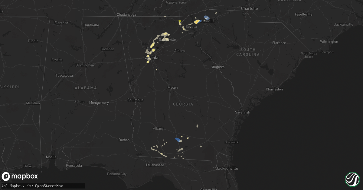
Hail Map in Georgia on June 26, 2025
Get this storm
June 26 map
$229
one time, instant access
Download today. No call, no setup
Keep the $229
Bought the map and want the full workflow? Apply the entire $229 to a subscription within 7 days. None of it is wasted.
Every map, not just this one
This buys you this map. Subscription and you get every map we run, in the markets you choose from a few cities to whole states to nationwide. Plus real-time alerts the moment a storm fires.
Contact data
Name, contact info, occupancy, even credit band for addresses in the footprint. You go from where it hit to who to call.
Become the source they trust
Unlimited branding weather history reports on demand. You already have the documented answer ready for the property owner, and you are the one who showed up with it.
Property data and RoofTrace estimates
Pull up any address you have got, its value and the exact code rules for that jurisdiction, straight from One Click Code. Then RoofTrace estimates the squares, pitch, and roof value, priced the way you price.
Storm reports in Georgia
Georgia
| Date | Description |
|---|---|
| 06/26/20255:34 PM CDT | Trees fell on several roads in grady county. |
| 06/26/20255:16 PM CDT | There were three reports of trees down in thomas county. |
| 06/26/20254:45 PM CDT | Quarter-sized hail reported near mableton. |
| 06/26/20254:38 PM CDT | Report of 1-inch hail at james jackson pkwy and bolton rd nw. |
| 06/26/20254:18 PM CDT | Measured 60.2 mph wind gust with rooftop anemometer. |
| 06/26/20254:18 PM CDT | A local report indicates 60 MPH wind near 1 E Laconte |
| 06/26/20254:05 PM CDT | Report from mping: quarter |
| 06/26/20254:03 PM CDT | Report of 1-inch hail in dunwoody. |
| 06/26/20254:03 PM CDT | Report of 1-inch hail at ison rd ne and roswell rd. |
| 06/26/20254:03 PM CDT | 1 inch hail reported at n peachtree rd. & starcross ct. |
| 06/26/20254:02 PM CDT | Tree reported down on dunwoody club way near the intersection of dunwoody club dr. |
| 06/26/20254:00 PM CDT | Picture with hail next to quarter from public near the intersection of n peachtree rd and starcross ct. |
| 06/26/20254:00 PM CDT | Power pole and lines downed near the intersection of dunwoody club dr and happy hollow rd... Leading to power outages in the neighborhood. |
| 06/26/20253:50 PM CDT | Tree down with powerlines down as well along the 2700 block of cox rd. |
| 06/26/20253:23 PM CDT | Report of 1-inch hail at birmingham rd and freemanville rd. |
| 06/26/20253:09 PM CDT | Couple of trees down near the 100 block of spring street. |
| 06/26/20253:09 PM CDT | Tree down at 800 block of chattahoochee st. |
| 06/26/20253:08 PM CDT | Tree down at 1800 block of tulip dr. |
| 06/26/20253:08 PM CDT | Tree down on gaines mill rd near shady lane drive. |
| 06/26/20253:07 PM CDT | Report via social media that a tree fell and took out a fence and power lines. |
| 06/26/20252:33 PM CDT | Report of a tree on a home on river sound ln. |
| 06/26/20252:33 PM CDT | Tree down at east lake dr and antioch campground rd. |
| 06/26/20252:20 PM CDT | Lowndes county dispatch reported trees down onto powerlines along gornto road. Timing estimated by radar. |
| 06/26/20252:19 PM CDT | Tree down at thompson bridge rd and mt vernon rd. |
| 06/26/20252:19 PM CDT | Multiple trees down near red oak flats rd. |
| 06/26/20252:19 PM CDT | Multiple trees down in old dahlonega. |
| 06/26/20252:05 PM CDT | Tree down at dahlonega hwy and clermont hwy. |
| 06/26/20252:04 PM CDT | Tree down at keinmer rd and ransom free rd. |
| 06/26/20251:54 PM CDT | Tree down at bowen bridge rd. |
| 06/26/20251:50 PM CDT | County communications reported trees and powerlines downed. Time estimated from radar. |
| 06/26/202512:04 PM CDT | Social media report of several large limbs down in the clayton area. |
All States Impacted by Hail Map on June 26, 2025
Cities Impacted by Hail Map on June 26, 2025
- Waynesboro, TN
- Church Hill, TN
- Kingsport, TN
- Gate City, VA
- Duffield, VA
- Clayton, GA
- Tiger, GA
- Lakemont, GA
- Long Creek, SC
- Hays, NC
- Jonesville, MI
- McGrady, NC
- Washington Court House, OH
- Jerome, MI
- Clarksburg, OH
- New Holland, OH
- Springfield, OH
- Cement City, MI
- Addison, MI
- Orient, OH
- Circleville, OH
- Frankford, DE
- Selbyville, DE
- Williamsport, OH
- Albert Lea, MN
- Garner, IA
- Columbus, OH
- Bishopville, MD
- Whaleyville, MD
- Hanover, NM
- Bloomingburg, OH
- Ashville, OH
- Archbold, OH
- Wauseon, OH
- Natchez, MS
- Roxie, MS
- Thurmond, NC
- Eastanollee, GA
- Lula, GA
- Gainesville, GA
- Clermont, GA
- Amanda, OH
- Lancaster, OH
- Murrayville, GA
- Lockbourne, OH
- Groveport, OH
- Elkin, NC
- Dahlonega, GA
- Canal Winchester, OH
- Willow, OK
- Port Saint Joe, FL
- Louisville, NE
- Springfield, NE
- Williamsburg, KY
- Stinnett, TX
- Bayard, NM
- Dawsonville, GA
- Wewahitchka, FL
- Fayette, MS
- Valdosta, GA
- Delaware, OH
- Hahira, GA
- Eastpoint, FL
- Galena, OH
- Sunbury, OH
- La Farge, WI
- Hillsboro, WI
- Hamilton, OH
- Wakarusa, IN
- Goshen, IN
- Elkhart, IN
- Nappanee, IN
- Syracuse, IN
- Millersburg, IN
- New Paris, IN
- Berlin, MD
- Brookshire, TX
- Inman, SC
- Houston, TX
- Ligonier, IN
- Rochester, MN
- Elgin, MN
- Eyota, MN
- Plainview, MN
- Dover, MN
- Saint Charles, MN
- Fredericktown, OH
- Starke, FL
- Wakeman, OH
- Saint Henry, OH
- Celina, OH
- Cumming, GA
- Gotebo, OK
- Cherryville, NC
- Canton, GA
- Richmond, VA
- Quitman, GA
- Ball Ground, GA
- Alpharetta, GA
- Maria Stein, OH
- Paulding, OH
- Greenville, SC
- Travelers Rest, SC
- Taylors, SC
- Greer, SC
- Liberty, SC
- Pickens, SC
- Easley, SC
- Roswell, GA
- Columbia City, IN
- Churubusco, IN
- Monroeville, IN
- Woodburn, IN
- Farmersville, OH
- New Lebanon, OH
- Miamisburg, OH
- Germantown, OH
- Woodstock, GA
- Live Oak, FL
- Payne, OH
- Gould, OK
- Cordell, OK
- Naples, FL
- Lanesboro, MN
- Beaver, OK
- Balko, OK
- Kutztown, PA
- Hamburg, PA
- Fleetwood, PA
- Morrow, OH
- Lebanon, OH
- Atlanta, GA
- Peachtree Corners, GA
- Six Mile, SC
- Binger, OK
- Gate, OK
- Fort Cobb, OK
- Hydro, OK
- Lockhart, TX
- Henrico, VA
- Mechanicsville, VA
- Central, SC
- Carnegie, OK
- Oregonia, OH
- Oakwood, GA
- Winchester, KS
- Easton, KS
- Atchison, KS
- Leavenworth, KS
- Jasper, FL
- Sledge, MS
- Hanover, PA
- Jennings, FL
- Minco, OK
- Weston, MO
- Rushville, MO
- Norris, SC
- Ashley, MI
- Lake Park, GA
- Calumet, OK
- Louisville, KY
- De Kalb, MO
- Dearborn, MO
- Winterset, IA
- Van Meter, IA
- Prole, IA
- Waukee, IA
- Cumming, IA
- Booneville, IA
- Clive, IA
- West Des Moines, IA
- Urbandale, IA
- Windsor Heights, IA
- Adel, GA
- Sparks, GA
- Lenox, GA
- Norman Park, GA
- Faucett, MO
- Fairdale, KY
- Shubert, NE
- Yorkshire, OH
- Prestonsburg, KY
- Gracemont, OK
- Roosevelt, OK
- Marietta, GA
- Edmond, OK
- Cornelius, NC
- Agency, MO
- Gower, MO
- Buckhorn, NM
- Huntersville, NC
- Zolfo Springs, FL
- Fort Peck, MT
- Lee, FL
- Denver, NC
- Lincolnton, NC
- Maiden, NC
- Iron Station, NC
- West Union, SC
- Red Oak, GA
- Union City, OK
- El Reno, OK
- Yukon, OK
- Mustang, OK
- Nemaha, NE
- Ochopee, FL
- Greenville, FL
- Perry, FL
- Scobey, MT
- Westminster, SC
- Wolf Point, MT
- Mableton, GA
- Winona, MN
- Dakota, MN
- Trempealeau, WI
- Holmen, WI
- Chiefland, FL
- Newberry, FL
- Winter Garden, FL
- Apopka, FL
- Ocoee, FL
- Marks, MS
- Martin, GA
- Waldron, MO
- Platte City, MO
- Smithville, MO
- Kansas City, MO
- Kearney, MO
- Trimble, MO
- Edgerton, MO
- Lamesa, TX
- Ackerly, TX
- Toccoa, GA
- Westminster, MD
- Okarche, OK
- Whitetail, MT
- Nashville, GA
- Albion, IN
- Lenhartsville, PA
- Inglis, FL
- Smyrna, GA
- Coxs Creek, KY
- Seneca, SC
- Austell, GA
- Greensboro, NC
- Reading, PA
- Wernersville, PA
- Laotto, IN
- Bardstown, KY
- Arkansas City, KS
- Clermont, KY
- Shepherdsville, KY
- Coyle, OK
- Stillwater, OK
- Newkirk, OK
- Burlington Junction, MO
- Orlando, OK
- Elgin, OK
- Apache, OK
- Bloomfield, KY
- Lenexa, KS
- Overland Park, KS
- Leawood, KS
- Prairie Village, KS
- Cement, OK
- Berlin Heights, OH
- Fort Myers, FL
- Independence, MO
- Mission, KS
- Chickasha, OK
- Miami, TX
- Dale, TX
- Mohnton, PA
- Lamont, FL
- Leesport, PA
- Bernville, PA
- Vernon, TX
- Brooks, KY
- Dawson, IA
- Ninnekah, OK
- Alva, FL
- Lake City, FL
- Willisburg, KY
- Morse, TX
- Lehigh Acres, FL
- Luling, TX
- North Fort Myers, FL
- Punta Gorda, FL
- Saint Joseph, MO
- Burlington, KY
- Union, KY
- Alapaha, GA
- Pembroke, VA
- Ripplemead, VA
- Narrows, VA
- Peterstown, WV
- Iaeger, WV
- Du Bois, NE
- Narvon, PA
- Peerless, MT
- Richland, MT
- Froid, MT
- Pearisburg, VA
- Union City, GA
- Fort White, FL
- Sanford, NC
- Pylesville, MD
- White Hall, MD
- Morgantown, PA
- East Earl, PA
- Honey Brook, PA
- Rantoul, KS
- Ottawa, KS
- Gap, PA
- Aurora, IL
- Plano, IL
- Big Rock, IL
- Sugar Grove, IL
- Elburn, IL
- Maple Park, IL
- Geneva, IL
- Saint Charles, IL
- Batavia, IL
- North Aurora, IL
- Holden, WV
- Paola, KS
- Osawatomie, KS
- Humboldt, NE
- Coatesville, PA
- Atglen, PA
- New Holland, PA
- Christiana, PA
- Parkesburg, PA
- Kinzers, PA
- Pawnee City, NE
- Spring Hill, KS
- Indiahoma, OK
- Mountain Park, OK
- Corwith, IA
- Mooseheart, IL
- West Chicago, IL
- Bartlett, IL
- Elgin, IL
- Wayne, IL
- South Elgin, IL
- Wasco, IL
- Hampshire, IL
- Dundee, IL
- Gilberts, IL
- Huntley, IL
- New Hill, NC
- Boston, GA
- Moncure, NC
- Chapmanville, WV
- Stollings, WV
- Logan, WV
- Trenton, FL
- Valley Park, MS
- Aurora, IN
- Troutville, VA
- Blue Ridge, VA
- Roanoke, VA
- Quarryville, PA
- Kirkwood, PA
- Dubuque, IA
- Peosta, IA
- East Dubuque, IL
- Hazel Green, WI
- Cuba City, WI
- Kieler, WI
- Whiting, KS
- Clearmont, MO
- Pickering, MO
- Skidmore, MO
- Maryville, MO
- Floral City, FL
- Brooksville, FL
- Inverness, FL
- Louisburg, KS
- Platteville, WI
- Jamaica, IA
- Bern, KS
- Chaplin, KY
- Braman, OK
- Roundup, MT
- Apex, NC
- Thomasville, GA
- Craig, MO
- Moultrie, GA
- Monticello, FL
- Coolidge, GA
- Snyder, OK
- Anadarko, OK
- Hinton, OK
- Faxon, OK
- Lambert, MT
- Nardin, OK
- Guthrie, OK
- Briceville, TN
- Mulhall, OK
- Perry, IA
- Seneca, KS
- Brooksville, KY
- Alkol, WV
- Griffithsville, WV
- Moores Hill, IN
- Spurlockville, WV
- Lexington, KY
- Walhalla, SC
- Oneida, KS
- Clifton, VA
- Fairfax Station, VA
- Manassas, VA
- Mcdonough, GA
- Collins, OH
- Sidney, MT
- Dunkirk, MD
- Lothian, MD
- Upper Marlboro, MD
- Brandywine, MD
- Hartsfield, GA
- Locust Grove, GA
- Hampton, GA
- Harts, WV
- Ochlocknee, GA
- Rising Sun, IN
- Meigs, GA
- Larslan, MT
- Harwood, MD
- Ranger, WV
- Granger, TX
- Taylor, TX
- Stevenson, AL
- Pelham, GA
- Thaxton, VA
- Bedford, VA
- Cairo, GA
- Vicksburg, MS
- Midkiff, WV
- Kiahsville, WV
- Springer, NM
- Oxford, NC
- Bullock, NC
- Independence, KY
- Morning View, KY
- Walton, KY
- Gilman, IA
- Whigham, GA
- Sunray, TX
- Alexandria, KY
- De Mossville, KY
- Butler, KY
- Falmouth, KY
- Foster, KY
- Urbana, IN
- Mundelein, IL
- Corning, KS
- Homerville, GA
- Sewanee, TN
- Lawton, OK
- Chattanooga, OK
- Nathalie, VA
- Gretna, VA
- Java, VA
- Texico, NM
- Bovina, TX
- Dumfries, VA
- Triangle, VA
- Carlisle, KY
- Tuttle, OK
- Genoa, WV
- Wayne, WV
- Hillsboro, TN
- Latty, OH
- Goff, KS
- Soldier, KS
- Arcadia, OK
- Ewing, KY
- Williamson, WV
- Wagon Mound, NM
- Wetmore, KS
- Balmorhea, TX
- Augusta, KY
- Flemingsburg, KY
- Fort Davis, TX
- Birdsboro, PA
- Dingess, WV
- Andrews, NC
- Oxford, PA
- Netawaka, KS
- Davy, WV
- Poplar, MT
- Westboro, MO
- Friona, TX
- Germantown, KY
- Mount Olivet, KY
- Dalton, OH
- Mount Eaton, OH
- Dundee, OH
- Navarre, OH
- Apple Creek, OH
- Walters, OK
- Airville, PA
- Fawn Grove, PA
- Delta, PA
- Hinckley, IL
- Sandwich, IL
- Independence, KS
- Elk City, KS
- Adrian, TX
- Hillsboro, KY
- Brockton, MT
- Marshalltown, IA
- Haverhill, IA
- Laurel, IA
- East Lynn, WV
- Climax, GA
- Blue Mound, KS
- Cache, OK
- Mountain View, OK
- Hollis, OK
- Petersburg, KY
- Young Harris, GA
- Healy, KS
- Montour, IA
- Paradise, PA
- Cochranville, PA
- Dumas, TX
- Falls City, NE
- Sherwood, TN
- Tonganoxie, KS
- Fort Sill, OK
- Eskdale, WV
- Cherryvale, KS
- Forsyth, MT
- Liberty, KS
- Homestead, MT
- Rising Sun, MD
- Colora, MD
- Conowingo, MD
- Blackwell, OK
- Rockwood, TN
- Spring City, TN
- Dodgeville, WI
- Belle Fourche, SD
- Geronimo, OK
- Hanna, IN
- Huntingdon, PA
- Branchland, WV
- Denton, GA
- West Green, GA
- Sedan, KS
- Mapleton Depot, PA
- Ansted, WV
- Kanawha Falls, WV
- Fayetteville, WV
- Gauley Bridge, WV
- Warne, NC
- Victor, WV
- Summersville, WV
- Drennen, WV
- Opheim, MT
- Flaxville, MT
- Onaga, KS
- La Junta, CO
- San Jon, NM
- Sedan, NM
- Clayton, NM
- Mosquero, NM
- Texline, TX
- Newell, SD
- Coffeyville, KS
- Pecks Mill, WV
- Broaddus, TX
- Mud Butte, SD
- Faith, SD
- Fairview, MT
- Havana, KS
- Miami, WV
- Hansford, WV
- Gallagher, WV
- Prichard, WV
- Fort Gay, WV
- Tucumcari, NM
- La Porte, IN
- Seymour, TX
- Little Birch, WV
- Birch River, WV
- Erbacon, WV
- Sutton, WV
- Belva, WV
- Montgomery, WV
- Neodesha, KS
- Cowen, WV
- Havensville, KS
- Denver City, TX
- Plains, TX
- Higginsville, MO
- Diana, WV
- Okeechobee, FL
- Nunica, MI
- Rothbury, MI
- Hesperia, MI
- Wanatah, IN
- Rosedale, LA
- La Crosse, IN
- Hamlet, IN
- Union Mills, IN
- Berrien Center, MI
- Lane, KS
- Maringouin, LA
- South Haven, KS
- Alzada, MT
- Fowler, IN
- Nottingham, PA
- Mill Creek, PA
- Blandon, PA
- Belle Plaine, KS
- Wellington, KS
- Medford, OK
- Mayview, MO
- Sunset, SC
- Troy, KS
- Wathena, KS


