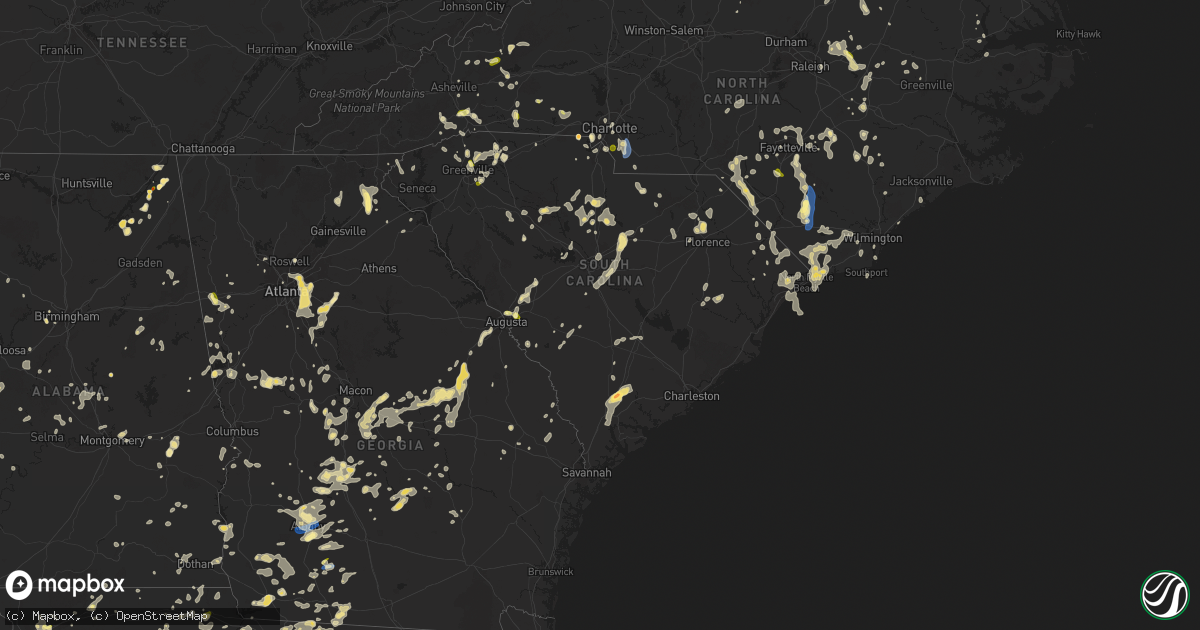
Hail Map in South Carolina on June 25, 2025
Get this storm
June 25 map
$229
one time, instant access
Download today. No call, no setup
Keep the $229
Bought the map and want the full workflow? Apply the entire $229 to a subscription within 7 days. None of it is wasted.
Every map, not just this one
This buys you this map. Subscription and you get every map we run, in the markets you choose from a few cities to whole states to nationwide. Plus real-time alerts the moment a storm fires.
Contact data
Name, contact info, occupancy, even credit band for addresses in the footprint. You go from where it hit to who to call.
Become the source they trust
Unlimited branding weather history reports on demand. You already have the documented answer ready for the property owner, and you are the one who showed up with it.
Property data and RoofTrace estimates
Pull up any address you have got, its value and the exact code rules for that jurisdiction, straight from One Click Code. Then RoofTrace estimates the squares, pitch, and roof value, priced the way you price.
Storm reports in South Carolina
South Carolina
| Date | Description |
|---|---|
| 06/25/20256:53 PM CDT | Scdps reported tree down on bel ivy rd near the intersection with floyd rd. Time estimated by radar. |
| 06/25/20256:48 PM CDT | Scdps website reported a tree down on i-95 over the black river swamp. Time estimated by radar. |
| 06/25/20256:48 PM CDT | Sc dps reports tree down over cecil mcfadden rd near gable. |
| 06/25/20256:46 PM CDT | Scdps website reported a tree down on i-95 near exit 132. Time estimated by radar. |
| 06/25/20256:45 PM CDT | Social media picture of a tree down in the mountville area. |
| 06/25/20256:45 PM CDT | Tree down on roadway at us-17a and sc-41. A car crashed into the tree a short time later - no injuries. |
| 06/25/20256:43 PM CDT | Scdps website reported a tree in roadway near the intersection of bethel church road and sanford drive. Time estimated by radar. |
| 06/25/20256:43 PM CDT | Trees down and a medal roof blown off barn. 176 adger road. Possible tornado. |
| 06/25/20256:42 PM CDT | Scdps website reported a tree down on us-321 near the intersection of airport road. Time estimated by radar. |
| 06/25/20256:36 PM CDT | Tree down on utility equipment. |
| 06/25/20256:36 PM CDT | Social media picture of trees down south of laurens. |
| 06/25/20256:31 PM CDT | Tree down along ab jackson rd. |
| 06/25/20256:30 PM CDT | Fairfield county |
| 06/25/20256:30 PM CDT | Fairfield county dispatch reports tree down on dave jenkins rd near blair. Time estimated by radar. |
| 06/25/20256:20 PM CDT | Lancaster county dispatch reported trees down on gold mine hwy at estridge ave. Time estimated by radar. |
| 06/25/20256:20 PM CDT | Outages near old richburg rd due to fallen trees and/or utility lines. |
| 06/25/20256:20 PM CDT | *** 1 inj *** large tree down on roadway. Kings river road at knight circle in pawleys island. Tree struck a pedestrian who was running on the bike path... Who was then |
| 06/25/20256:20 PM CDT | Large tree down on roadway. Kings river road at knight circle in pawleys island. |
| 06/25/20256:15 PM CDT | Tree down in roadway. Rose hill and antwine drive in georgetown. |
| 06/25/20256:15 PM CDT | Tree down on sc-51 near hemingway lane. Time estimated via radar. A car crashed into the tree a short time later - no injuries. |
| 06/25/20256:10 PM CDT | Tree down on a powerline in pelzer. |
| 06/25/20256:00 PM CDT | Approx 3000 outages around spartanburg due to tree and utility line damage. Event time is based on radar. |
| 06/25/20256:00 PM CDT | Large down in the roadway... 3600 block of old pee dee road in hemingway. Time estimated via radar |
| 06/25/20256:00 PM CDT | Quarter-sized hail near intersection of cheyenne dr. And capewood rd. Time estimated from radar. |
| 06/25/20255:56 PM CDT | Trees and powerlines down around the fountain inn area. |
| 06/25/20255:55 PM CDT | Trees downed along regent pkwy. |
| 06/25/20255:55 PM CDT | Lancaster county dispatch reported trees down on camp creek rd at mockingbird rd. Time estimated by radar. |
| 06/25/20255:51 PM CDT | Sc highway patrol reports tree down on forest lake dr between s stanley dr and s knollwood rd |
| 06/25/20255:50 PM CDT | Spotter reports trees down and power outages in florence... Sc |
| 06/25/20255:50 PM CDT | Numerous large limbs downed in the travelers rest area. |
| 06/25/20255:48 PM CDT | Trees and powerlines down in the powdersville area. |
| 06/25/20255:42 PM CDT | Trees down on roof of home near ridge rd at glenn rd. Time based on radar. |
| 06/25/20255:41 PM CDT | Golf ball hail at ridge rd and glenn rd. Time estimated from radar. |
| 06/25/20255:40 PM CDT | Tree down on elm st in conway... Near 16th ave. Time estimated via radar. |
| 06/25/20255:38 PM CDT | Social media picture of trees down in simpsonville. |
| 06/25/20255:36 PM CDT | Up to quarter size hail fell along hudson st in taylors. |
| 06/25/20255:36 PM CDT | Numerous large limbs and several trees downed in the vicinity of downtown greenville. |
| 06/25/20255:36 PM CDT | Social media picture of a tree down in mauldin. |
| 06/25/20255:29 PM CDT | Tree down on chestnut st in darlington |
| 06/25/20255:25 PM CDT | Several trees and powerlines down on the west side of spartanburg. |
| 06/25/20255:25 PM CDT | Tree down on road at hartsville hwy and bethlehem rd. Time estimated via radar. |
| 06/25/20255:24 PM CDT | Sc highway patrol reports tree down on us-701 and sc-22 |
| 06/25/20255:20 PM CDT | Tree down across aviation parkway. |
| 06/25/20255:15 PM CDT | Sc highway patrol reports tree down on macedonia dr between heritage rd and red bluff rd. Time estimated via radar. |
| 06/25/20255:15 PM CDT | Approx 2000 outages due to fallen trees and utility lines from tigerville south to greenville. Time ranged from 600 to 630 pm. |
| 06/25/20255:13 PM CDT | Several trees down around the tigerville area... Some on powerlines. |
| 06/25/20255:10 PM CDT | Lancaster dispatch reported trees down at barberville rd at harrisburg rd. Time estimated by radar. |
| 06/25/20255:10 PM CDT | A smattering of downed trees and powerlines between east gaffney and cherokee falls. |
| 06/25/20255:08 PM CDT | Trees down near john dodd and new cut roads. |
| 06/25/20255:05 PM CDT | Report of tree down on mechanicsville hgwy near greenfield rd |
| 06/25/20255:00 PM CDT | Sc highway patrol reports tree down on green sea rd near church rd. Time estimated via radar. |
| 06/25/20254:52 PM CDT | Social media report of dime to quarter size hail in the boiling springs area. |
| 06/25/20254:50 PM CDT | Tree down. Time estimated from radar. |
| 06/25/20254:48 PM CDT | Two trees down in separate locations in landrum. Time estimated from radar. |
| 06/25/20254:39 PM CDT | Tree down on sc-9 near covington rd |
| 06/25/20254:25 PM CDT | Tree down in hamer... Sc |
| 06/24/20259:56 PM CDT | Emergency manager reported a tree down on the block of 1500 wichman street. It's blocking both lanes. |
| 06/24/20259:53 PM CDT | Emergency manager reported a tree down on the block of 15800 hendersonville highway. It's blocking both lanes. |
| 06/24/20259:51 PM CDT | Emergency manager reported a tree down on public landing lane. |
| 06/24/20259:39 PM CDT | Emergency manager reported at tree down on the 11500 block of hendersonville highway. It is blocking both lanes. |
| 06/24/20259:27 PM CDT | Tree down on residence at pentgage ct. Time estimated from radar. |
| 06/24/20259:27 PM CDT | Tree down along 500 block of roadside dr. Time was estimated via radar data. |
| 06/24/20259:24 PM CDT | Tree down on residence along the 100 block of fannie lane. Time was estimated via radar data. |
| 06/24/20259:20 PM CDT | Emergency manager reported golf ball sized hail |
| 06/24/20259:15 PM CDT | Tree down on black creek rd. Time estimated from radar. |
| 06/24/20259:14 PM CDT | Tree down on 10000 combahee rd. Time estimated from radar. |
| 06/24/20259:14 PM CDT | Emergency manager reported a tree down on the 2000 block of mewville road. It's blocking both lanes. |
| 06/24/20259:10 PM CDT | Emergency man |
| 06/24/20259:10 PM CDT | Emergency manager reported a tree down and power lines down on the block of 5400 cross swamp road. Both lanes were blocked. |
| 06/24/20259:01 PM CDT | Tree down along brick rd. Time was estimated via radar data. |
| 06/24/20259:01 PM CDT | Emergency manager reported at tree down at the intersection of azalea patch road and bethel road. It's blocking both lanes. |
| 06/24/20258:57 PM CDT | A local report indicates 1.00 inch wind near 1 N Burnettown |
| 06/24/20258:52 PM CDT | Tree down along hydrick rd and lowcountry hwy. Time was estimated via radar data. |
| 06/24/20258:52 PM CDT | Emergency manager reported a tree down on the block of 1500 wichman street. It's blocking both lanes. |
| 06/24/20258:49 PM CDT | Tree down along lumber rd and avalon dr. Time was estimated via radar data. |
| 06/24/20258:45 PM CDT | Scdps website reported a tree down on binnicker bridge road near the intersection of good hope road. Time estimated by radar. |
| 06/24/20258:43 PM CDT | South carolina highway patrol reported a tree down and in the roadway on maybank highway near rackity hall road. |
| 06/24/20258:42 PM CDT | Emergency manager reported a tree and power line down on the 3600 block of mount carmel road. One lane of the road was blocked. |
| 06/24/20258:40 PM CDT | Emergency manager reported a tree down on the 216 exit ramp of i-26w. |
| 06/24/20258:40 PM CDT | Emergency manager reported a tree down on nautical chart drive. |
| 06/24/20258:40 PM CDT | Emergency manager reported a tree down on the intersection of bayview farms blvd and fort johnson rd. |
| 06/24/20258:40 PM CDT | Emergency manager reported a tree down on larry street. |
| 06/24/20258:30 PM CDT | Media reports quarter size hail from multiple viewers in belvedere and north augusta. |
| 06/24/20258:26 PM CDT | A local report indicates 1.00 inch wind near 5 N Aiken Municipal Apt |
| 06/24/20258:14 PM CDT | Sc dps reports tree on i-20 near pineview estates. Time estimated by radar. |
| 06/24/20258:14 PM CDT | Sc dps reports tree on i-20 near pineview e |
| 06/24/20258:07 PM CDT | Scdps website reported a tree down on us-178 near the intersection of whetstone road. Time estimated by radar. |
| 06/24/20258:05 PM CDT | Amateur radio spotter reports trees down blocking wannaridge rd as well as stabler farm rd. Time estimated by radar. |
| 06/24/20258:05 PM CDT | Sc dps reports tree down on swansea rd near the intersection of hwy 178. Time estimated by radar. |
| 06/24/20258:03 PM CDT | Trees down at w cherry rd and evening shade rd. |
| 06/24/20258:03 PM CDT | Scdps website reported a tree down on old swamp road near the intersection of old state highway. Time estimated by radar. |
| 06/24/20258:01 PM CDT | Tree down on long point rd. Time estimated from radar. |
| 06/24/20258:00 PM CDT | Scdps reported trees down on bluff rd near sims rd. Time estimated by radar. |
| 06/24/20257:58 PM CDT | Scdps reported trees down on patricia drive. Time estimated by radar. |
| 06/24/20257:52 PM CDT | Lexington county communications center reported power line or power poles down near this address. Time estimated by radar. |
| 06/24/20257:49 PM CDT | Scdps reported trees down on mill stream rd near hope ferry rd. Time estimated by radar. |
| 06/24/20257:47 PM CDT | Lexington county communications center reported a large tree blocking the roadway on fairview road near ranch road. Time estimated by radar. |
| 06/24/20257:44 PM CDT | Scdps reported trees down on amicks ferry rd at ballentine lane. Time estimated by radar. |
| 06/24/20257:43 PM CDT | Ema reports several trees down between cainhoy and huger. Time estimated from radar. |
| 06/24/20257:43 PM CDT | Tree down on sprig ct. Time estimated from radar. |
| 06/24/20257:43 PM CDT | Trees down at s radio station rd and pruitt rd. |
| 06/24/20257:40 PM CDT | Social media picture shows a tree down across residential driveway located along hatchway dr likely due to thunderstorm outflow. Time was estimated via radar data. |
| 06/24/20257:37 PM CDT | Scdps reported trees down on north wingard rd at western lane. Time estimated by radar. |
| 06/24/20257:35 PM CDT | Tree down on unoccupied vehicle near promise ln. Time estimated from radar. |
| 06/24/20257:30 PM CDT | Several trees reported down from moncks corner to st. Stephen. Time estimated from radar. |
| 06/24/20257:30 PM CDT | Powerlines down on roadway on land bridge rd. |
| 06/24/20257:30 PM CDT | Scdps reported trees down on muller road near persimmon fork rd. Time estimated by radar. |
| 06/24/20257:30 PM CDT | Pinopolis gusted to 62 mph. |
| 06/24/20257:29 PM CDT | Law enforcement reported a tree in roadway near the intersection of state rd and mudville rd likely due to thunderstorm outflow. Time was estimated via radar data. |
| 06/24/20257:21 PM CDT | Richland county em reported a tree on a power line causing a brush fire. Time estimated by radar. |
| 06/24/20257:21 PM CDT | Tree down across the road on bethera and boggy swamp rd. |
| 06/24/20257:19 PM CDT | Trees down at whetstone rd and cassidy ridge rd. |
| 06/24/20257:18 PM CDT | Tree down on mail route rd. Time estimated from radar. |
| 06/24/20257:16 PM CDT | Scdps reported trees down on heins rd. Time estimated by radar. |
| 06/24/20257:15 PM CDT | Broadcast met and other public reports of multiple trees down along arcadia springs circle including at least tree on a home. |
| 06/24/20257:13 PM CDT | Tree down on heaven dr. Time estimated from radar. |
| 06/24/20257:13 PM CDT | Tree down across roadway on russellville rd. |
| 06/24/20257:11 PM CDT | Richland county em reported a tree down on a power line with nearby trees on fire off adams rd. Time estimated by radar. |
| 06/24/20257:10 PM CDT | Columbia fire dept reported a collapsed structure. Time estimated by radar. |
| 06/24/20257:10 PM CDT | Large tree fell across and blocked highway 21 and i-20 on-ramp. Numerous snapped large branches and small trees down along highway 21 south of i-77. |
| 06/24/20257:10 PM CDT | Kershaw county fire reported multiple trees down in the elgin area. Time estimated by radar. |
All States Impacted by Hail Map on June 25, 2025
Cities Impacted by Hail Map on June 25, 2025
- Romney, WV
- Madison, VA
- Pratts, VA
- Aroda, VA
- Rochelle, VA
- Purgitsville, WV
- Augusta, WV
- Capon Bridge, WV
- Norlina, NC
- Manson, NC
- Baskerville, VA
- Boydton, VA
- Warrenton, NC
- Knightdale, NC
- Macon, NC
- Raleigh, NC
- Hampstead, NC
- Smithfield, NC
- Sopchoppy, FL
- Henderson, NC
- Burgaw, NC
- Maple Hill, NC
- Marion, NC
- Newland, NC
- Clinton, NC
- Newton Grove, NC
- Beulaville, NC
- Princeton, NC
- Hosford, FL
- Tellico Plains, TN
- Greenville, FL
- Hollister, NC
- Goldsboro, NC
- Eagle Butte, SD
- Wakpala, SD
- Mobridge, SD
- Glenham, SD
- Mound City, SD
- Salemburg, NC
- Roseboro, NC
- Apalachicola, FL
- Herndon, VA
- Spruce Pine, NC
- Terre Haute, IN
- Zebulon, NC
- Bunn, NC
- Enfield, NC
- Louisburg, NC
- Moultrie, GA
- Hartsfield, GA
- Mount Olive, NC
- Whitakers, NC
- Fowler, IL
- Raeford, NC
- Sterling, VA
- Burnsville, NC
- Columbus, NE
- Monroe, NE
- Dunn, NC
- Pikeville, NC
- Clayton, IN
- Collettsville, NC
- Mooresville, IN
- Sims, NC
- Meigs, GA
- Lumber Bridge, NC
- Youngsville, NC
- Fayetteville, NC
- Turkey, NC
- Peyton, CO
- Calhan, CO
- Animas, NM
- Chantilly, VA
- Rose Hill, NC
- Wewahitchka, FL
- Lucama, NC
- Saint Pauls, NC
- Shannon, NC
- Kenansville, NC
- Magnolia, NC
- Warsaw, NC
- Perry, FL
- Reston, VA
- Fairfax, VA
- Centreville, VA
- Plainfield, IN
- Brazil, IN
- Stockville, NE
- Smithland, IA
- Glenmont, OH
- Brinkhaven, OH
- Killbuck, OH
- Bertrand, NE
- Loomis, NE
- Holdrege, NE
- Wilson, NC
- Fremont, NC
- Kenly, NC
- Port Saint Joe, FL
- Wake Forest, NC
- Pasadena, MD
- Millersville, MD
- Hinton, VA
- Harrisonburg, VA
- Bristol, FL
- Tallahassee, FL
- West Point, NE
- Wisner, NE
- Dodge, NE
- Rolesville, NC
- Indianapolis, IN
- Greenwood, IN
- Oakland, NE
- Middlesex, NC
- Bessemer, AL
- Oto, IA
- Mapleton, IA
- Bailey, NC
- Bolivia, NC
- Winnabow, NC
- Mulga, AL
- Boaz, AL
- Albertville, AL
- Beemer, NE
- Spring Hope, NC
- Wilmington, NC
- Crossville, AL
- Colorado Springs, CO
- Carbon, IN
- Fyffe, AL
- Geraldine, AL
- Nebo, NC
- White Oak, NC
- Hope Mills, NC
- Central City, NE
- Platte Center, NE
- Wendell, NC
- Los Alamos, NM
- Circle, MT
- Red Springs, NC
- Maxton, NC
- Fairfax Station, VA
- Verbena, AL
- Lamont, FL
- Faison, NC
- Atlanta, NE
- Broken Bow, NE
- Callaway, NE
- Eustis, NE
- Elwood, NE
- Funston, GA
- Elm Creek, NE
- Funk, NE
- Kearney, NE
- Riverdale, NE
- Odessa, NE
- Axtell, NE
- Pleasanton, NE
- Ravenna, NE
- Minden, NE
- Gibbon, NE
- Wagram, NC
- Casper, WY
- Danbury, IA
- Elm City, NC
- Barnardsville, NC
- Thurmont, MD
- Rocky Ridge, MD
- Emmitsburg, MD
- Severna Park, MD
- Crownsville, MD
- Sale City, GA
- Alden, MN
- Doerun, GA
- District Heights, MD
- Suitland, MD
- Capitol Heights, MD
- Upper Marlboro, MD
- Andrews Air Force Base, MD
- Clinton, MD
- Brandywine, MD
- Cheltenham, MD
- Wellington, CO
- Carr, CO
- Craig, NE
- Laurinburg, NC
- Campbell, NE
- Schuyler, NE
- Holstein, NE
- Ramah, CO
- Grand Island, NE
- Tar Heel, NC
- Elizabethtown, NC
- Kenesaw, NE
- Shelton, NE
- Chapman, NE
- Gillette, WY
- Brockway, MT
- Clarkton, NC
- Bladenboro, NC
- Hartland, MN
- Cozad, NE
- Lexington, NE
- Autryville, NC
- Nunn, CO
- Pittsboro, IN
- North Salem, IN
- Danville, IN
- Lizton, IN
- Section, AL
- Sylacauga, AL
- Weogufka, AL
- Spencer, TN
- Crawfordville, FL
- Cheyenne, WY
- Wade, NC
- Stedman, NC
- Marston, NC
- Spring Valley, MN
- Ostrander, MN
- Coalmont, TN
- Gruetli Laager, TN
- Tracy City, TN
- Havana, FL
- Washington, DC
- Ashton, NE
- Farwell, NE
- Boelus, NE
- Dannebrog, NE
- Cairo, NE
- Saint Paul, NE
- Rockville, NE
- Elba, NE
- Wood River, NE
- Whiteville, NC
- Delco, NC
- Godwin, NC
- Rowland, NC
- Hallsboro, NC
- Asheville, NC
- Plymouth, IL
- Hill City, SD
- Laurel Hill, NC
- Jordan, MT
- Saint Marks, FL
- Panama City, FL
- Bainbridge, GA
- Bellevue, OH
- Monroeville, OH
- Willard, OH
- Norwalk, OH
- North Fairfield, OH
- Forest City, NC
- Bostic, NC
- Lawndale, NC
- Dutton, AL
- Pisgah, AL
- Scotia, NE
- Wolbach, NE
- Magdalena, NM
- Alzada, MT
- Greeley, NE
- Buckhannon, WV
- Gibson, NC
- Henagar, AL
- Flat Rock, AL
- Inlet Beach, FL
- Lake Waccamaw, NC
- Bolton, NC
- Linden, NC
- Dunlap, TN
- Ash, NC
- Fairmont, NC
- Hamer, SC
- Bowling Green, FL
- Wauchula, FL
- Chipley, FL
- Youngstown, FL
- Faribault, MN
- Kenyon, MN
- Spalding, NE
- Charlotte, NC
- Waxhaw, NC
- Matthews, NC
- Primrose, NE
- Ebro, FL
- Clarks, NE
- Silver Creek, NE
- Rozet, WY
- Stevenson, AL
- Hendersonville, NC
- Sneads Ferry, NC
- Jacksonville, NC
- Palmer, TN
- Heartwell, NE
- Hornick, IA
- Rodney, IA
- Santa Rosa Beach, FL
- Pisgah Forest, NC
- Panama City Beach, FL
- Spindale, NC
- Phillips, NE
- Doniphan, NE
- Lake View, SC
- Pensacola, FL
- Flat Rock, NC
- Grand Mound, IA
- Moorcroft, WY
- De Witt, IA
- Dodge Center, MN
- Charlotte, IA
- Delmar, IA
- Goose Lake, IA
- Rushford, MN
- Houston, MN
- Blountstown, FL
- Milton, FL
- Saluda, NC
- Vass, NC
- Penrose, NC
- Leland, NC
- Bennettsville, SC
- Orrum, NC
- Moatsville, WV
- Spring Lake, NC
- Pope Army Airfield, NC
- Fort Bragg, NC
- Fair Bluff, NC
- Nichols, SC
- Mullins, SC
- Loris, SC
- Green Sea, SC
- Clinton, IA
- Fulton, IL
- Marianna, FL
- Cottondale, FL
- Belle Fourche, SD
- Rapid City, SD
- Keystone, SD
- Conway, SC
- Genoa, NE
- North Myrtle Beach, SC
- Little River, SC
- Calabash, NC
- Sunset Beach, NC
- Blenheim, SC
- Darlington, SC
- Longs, SC
- Beersheba Springs, TN
- Cherryville, NC
- Bessemer City, NC
- Kings Mountain, NC
- Clarion, IA
- Eagle Grove, IA
- Lancaster, SC
- Fort Payne, AL
- Valley Head, AL
- Rutherfordton, NC
- Woodrow, CO
- Monroe, NC
- Baker, MT
- Upton, WY
- Glenrock, WY
- Carolina Beach, NC
- Myrtle Beach, SC
- Shelby, NC
- Quincy, FL
- Aquasco, MD
- Horse Shoe, NC
- Kershaw, SC
- Sundance, WY
- Caledonia, MN
- Hokah, MN
- Clover, SC
- Gastonia, NC
- Crestview, FL
- Pikeville, TN
- South Boston, VA
- Crossville, TN
- Douglas, WY
- Gaffney, SC
- Nakina, NC
- Pineville, NC
- Fort Mill, SC
- Clewiston, FL
- South Bay, FL
- De Graff, OH
- Indian Trail, NC
- Tiffin, OH
- Green Springs, OH
- Wheatland, WY
- Carthage, NC
- Union Springs, AL
- Huntingtown, MD
- Mobile, AL
- Rhame, ND
- Camp Crook, SD
- Lake City, MN
- Simpsonville, SC
- Wabasha, MN
- Travelers Rest, SC
- Arcadia, SC
- Spartanburg, SC
- Zirconia, NC
- Sparta, TN
- Quebeck, TN
- Doyle, TN
- Inman, SC
- Greer, SC
- Tabor City, NC
- Santa Fe, NM
- Boiling Springs, SC
- Wabash, IN
- Urbana, IN
- Lagro, IN
- Wall, SD
- Quinn, SD
- Kadoka, SD
- La Crosse, WI
- Bangor, WI
- Wellford, SC
- Cleveland, SC
- Nemaha, IA
- Brevard, NC
- Chattahoochee, FL
- Duncan, SC
- Startex, SC
- Taylors, SC
- Ocean Isle Beach, NC
- Longwood, NC
- Lyman, SC
- Buffalo, SD
- Lagrange, WY
- Mcminnville, TN
- Greenville, SC
- Monticello, FL
- Boston, GA
- Hartsville, SC
- Pickens, SC
- South Charleston, OH
- Lamar, SC
- Marietta, SC
- Eitzen, MN
- Albany, GA
- Nesmith, SC
- Kingstree, SC
- Vernon, FL
- Society Hill, SC
- Oak Island, NC
- Jefferson, SC
- Una, SC
- Mauldin, SC
- Cades, SC
- York, SC
- Fort Collins, CO
- Southport, NC
- Easley, SC
- Clarendon, NC
- Bremen, GA
- Waco, GA
- Bishopville, SC
- McBee, SC
- Dixie, GA
- Fitzgerald, GA
- Winnsboro, SC
- Liberty Hill, SC
- Ridgeway, SC
- Belmont, NC
- Sylvester, GA
- Rock Hill, SC
- Summerfield, OH
- Sarahsville, OH
- Sumner, GA
- Carrollton, GA
- Thomasville, GA
- Shallotte, NC
- Terry, MT
- Alford, FL
- Timmonsville, SC
- Fountain, FL
- Knox, IN
- Fork, SC
- Supply, NC
- Clinton, SC
- Laurens, SC
- Lugoff, SC
- Elgin, SC
- Blackstock, SC
- Chester, SC
- Leesburg, GA
- Wenona, IL
- Waelder, TX
- Rosanky, TX
- Altha, FL
- Camden, SC
- Brinson, GA
- Williamsburg, NM
- Dayton, VA
- Columbia, SC
- Eastover, SC
- Hopkins, SC
- Rockton, IL
- Rockford, IL
- South Beloit, IL
- Roscoe, IL
- Beloit, WI
- Clinton, WI
- Bascom, FL
- Greenwood, FL
- Bagdad, FL
- Grand Ridge, FL
- Mountain Rest, SC
- Janesville, WI
- Archer, NE
- Early, IA
- Newell, IA
- Whitmire, SC
- Carlisle, SC
- Blair, SC
- Ochlocknee, GA
- Donalsonville, GA
- Sanford, NC
- Robbins, NC
- Littleton, NC
- Arcadia, OH
- Pavo, GA
- Pelham, GA
- Dillon, SC
- Great Falls, SC
- Seven Springs, NC
- North Augusta, SC
- Campbellton, FL
- Monessen, PA
- Monongahela, PA
- Donora, PA
- Bowman, SC
- Colerain, NC
- Philippi, WV
- Boncarbo, CO
- Weston, CO
- Trinidad, CO
- Clayton, GA
- Graniteville, SC
- Warrenville, SC
- Beech Island, SC
- Cleveland, GA
- Winston, NM
- Chugwater, WY
- Aynor, SC
- Graceville, FL
- Salem, SC
- Walhalla, SC
- Rowesville, SC
- Branchville, SC
- Longmont, CO
- Erie, CO
- Merry Hill, NC
- Slocomb, AL
- Leary, GA
- Damascus, GA
- Plymouth, NC
- Windsor, NC
- Yemassee, SC
- Walterboro, SC
- Roswell, GA
- Blakely, GA
- Arlington, GA
- Murrayville, GA
- Marquette, NE
- Tallmansville, WV
- Gresham, SC
- Lewisville, OH
- Newberry, SC
- Mount Croghan, SC
- Fort Peck, MT
- Silverstreet, SC
- Tuskegee, AL
- Montgomery, AL
- Tallapoosa, GA
- Appomattox, VA
- Pamplin, VA
- Wetumpka, AL
- Windsor, IL
- Alpharetta, GA
- Smithton, PA
- Sautee Nacoochee, GA
- Baconton, GA
- Westminster, CO
- Arvada, CO
- Denver, CO
- Commerce City, CO
- Greenwich, OH
- Chapin, SC
- Irmo, SC
- Florence, SC
- Abbeville, GA
- Castana, IA
- Cairo, GA
- Republic, OH
- Attica, OH
- Kennesaw, GA
- Ridge Spring, SC
- Danville, OH
- Lower Salem, OH
- Richburg, SC
- Whigham, GA
- Aurora, CO
- Dacono, CO
- Thornton, CO
- Brighton, CO
- Henderson, CO
- Firestone, CO
- Bonifay, FL
- Fort Gaines, GA
- Mill Hall, PA
- Beech Creek, PA
- Lafayette, CO
- Raton, NM
- Clarkesville, GA
- Gaston, SC
- Swansea, SC
- Trenton, SC
- Aiken, SC
- Johnston, SC
- Macclesfield, NC
- Pinetops, NC
- Camilla, GA
- Rockford, AL
- Oshkosh, NE
- Deming, NM
- Goldfield, IA
- Victoria, VA
- Sac City, IA
- Fonda, IA
- Marbury, AL
- La Junta, CO
- Las Animas, CO
- Fountain, NC
- Hillsboro, NM
- Laurel, MS
- Trinchera, CO
- Branson, CO
- Mount Airy, GA
- Ruffin, SC
- Horseshoe Beach, FL
- Truth Or Consequences, NM
- Climax, GA
- Early Branch, SC
- Seminole, FL
- Saint Petersburg, FL
- Demorest, GA
- Coolidge, GA
- Defuniak Springs, FL
- Seale, AL
- Rocky Mount, NC
- Cornelia, GA
- Hartford, AL
- Baldwin, GA
- Marion, AL
- Pittsview, AL
- Elba, AL
- Witt, IL
- Fallon, MT
- Irving, IL
- Indian Rocks Beach, FL
- Shorterville, AL
- Clearwater, FL
- Pinellas Park, FL
- Largo, FL
- Newton, GA
- Zolfo Springs, FL
- Colquitt, GA
- Inglis, FL
- Dunnellon, FL
- Augusta, GA
- Laurel Hill, FL
- Crystal River, FL
- Fowler, IN
- Rockmart, GA
- Temple, GA
- Brundidge, AL
- Jack, AL
- Dahlonega, GA
- Toccoa, GA
- Cassatt, SC
- Poulan, GA
- Florala, AL
- Cottonwood, AL
- Malone, FL
- Luverne, AL
- Gordon, GA
- Gilbert, SC
- Blythe, GA
- Ariton, AL
- Little Mountain, SC
- Opp, AL
- Covington, GA
- Oxford, GA
- Foxworth, MS
- Tylertown, MS
- Louisville, GA
- Westville, FL
- State Line, MS
- Columbia, AL
- Jeffersonville, GA
- Bartow, GA
- Aurora, NE
- Glendive, MT
- Kettle Falls, WA
- Oakfield, GA
- Atlanta, GA
- Clarkston, GA
- Tucker, GA
- Decatur, GA
- Stone Mountain, GA
- Conyers, GA
- Dry Branch, GA
- Wadley, GA
- Dothan, AL
- Springer, NM
- Mcdonough, GA
- Dunedin, FL
- Palm Harbor, FL
- Poplar, MT
- Tarboro, NC
- Centreville, AL
- Eagle Springs, NC
- Renwick, IA
- Clio, AL
- Thomaston, GA
- Manchester, GA
- Woodbury, GA
- Molena, GA
- Abbeville, AL
- Lithonia, GA
- Ellenwood, GA
- Smoaks, SC
- Louisville, AL
- Clayton, AL
- Stockbridge, GA
- Wrightsville, GA
- Harrison, GA
- Pine Lake, GA
- Scottdale, GA
- Avondale Estates, GA
- Eight Mile, AL
- Kokomo, MS
- Giltner, NE
- De Soto, GA
- Chancellor, AL
- Ashford, AL
- Monetta, SC
- Warm Springs, GA
- Theodore, AL
- Cordele, GA
- Cobb, GA
- Holt, FL
- Baker, FL
- Hartwell, GA
- Bowersville, GA
- Eglin Afb, FL
- Gantt, AL
- Jacksonville, GA
- Lock Haven, PA
- Bronwood, GA
- Newton, AL
- Midland City, AL
- Milan, GA
- Rhine, GA
- Leslie, GA
- Dawson, GA
- Ashburn, GA
- Monticello, MS
- Newellton, LA
- Whitesburg, GA
- Vienna, GA
- Greenville, NC
- Canon, GA
- Royston, GA
- Jayess, MS
- Rainsville, AL
- Woodland, GA
- Evant, TX
- Hamilton, TX
- Sardis, OH
- Clarington, OH
- Nashville, NC
- Warwick, GA
- Norway, SC
- Halifax, VA
- Americus, GA
- Byromville, GA
- Williston, SC
- Blackville, SC
- Villa Rica, GA
- Raymond, MS
- Kite, GA
- Caldwell, OH
- Selma, AL
- Jackson, SC
- Barnwell, SC
- Millbrook, AL
- Prattville, AL
- Matthews, GA
- Byram, MS
- Hephzibah, GA
- Camden, AL
- Adrian, GA
- Vancleave, MS
- Danville, VA
- Ringgold, VA
- Rockledge, GA
- Highland Home, AL
- Pinehurst, GA
- Pitts, GA
- Milton, NC
- Blanch, NC
- Providence, NC
- Sutherlin, VA
- Yanceyville, NC
- Wrens, GA
- Lucedale, MS
- Vinegar Bend, AL
- Fruitdale, AL
- Rochelle, GA
- Deatsville, AL
- Blairs, VA
- Dublin, GA
- Avera, GA
- Preston, GA
- Richland, GA
- Homosassa, FL
- Safety Harbor, FL
- Lumpkin, GA
- Omaha, GA
- Platteville, CO
- Fort Mitchell, AL
- Cape Coral, FL
- North Fort Myers, FL
- Davisboro, GA
- Fairfield, AL
- Arabi, GA
- Deer Park, AL
- Chatom, AL
- Catherine, AL
- Autaugaville, AL
- Billingsley, AL
- Linden, AL
- Eufaula, AL
- Wray, GA
- Jones, AL
- Luling, TX
- Albany, OH
- Edwards, MS
- Utica, MS
- Tibbie, AL
- McIntosh, AL
- Wagarville, AL
- Sandersville, GA
- Hardaway, AL
- Birmingham, AL
- Waynesboro, GA
- Shorter, AL
- Marshallville, GA
- Grant, NE
- Madrid, NE
- Loveland, CO
- Acworth, GA
- Cross City, FL
- Montezuma, GA
- Elko, GA
- Perry, GA
- Holyoke, CO
- Fort Valley, GA
- Leakesville, MS
- Thomaston, AL
- Sylvania, GA
- Ty Ty, GA
- Marietta, GA
- Tuscumbia, AL
- Leighton, AL
- Millen, GA
- Junction City, GA
- Portal, GA
- Tennille, GA
- Plantersville, AL
- Gretna, VA
- McRae Helena, GA
- Duck, WV
- Nebo, WV
- Roberta, GA
- Clanton, AL
- New Martinsville, WV
- Proctor, WV
- Statesboro, GA
- Bonaire, GA
- Locust Grove, GA
- Cochran, GA
- Reynolds, GA
- Dawson, AL
- New Port Richey, FL
- Tarpon Springs, FL
- Newington, GA
- Kathleen, GA
- Byron, GA
- Akron, AL
- Moundville, AL
- Greensboro, AL
- Ridgeland, SC
- Sheldon, SC
- Lecanto, FL
- Port Richey, FL
- Guntersville, AL
- Collinsville, AL
- Warner Robins, GA
- Toomsboro, GA
- Loganville, GA
- Fosters, AL
- East Dublin, GA
- Danville, GA
- Barnesville, GA
- Macon, GA
- Forsyth, GA
- Brooklet, GA
- Guyton, GA
- Lizella, GA
- Unadilla, GA
- Hawkinsville, GA
- Dudley, GA
- Dexter, GA
- Glenwood, GA
- Claxton, GA
- West Blocton, AL
- Pineview, GA
- Brierfield, AL
- Tuscaloosa, AL
- Old Town, FL
- Montrose, GA
- Colona, IL
- Julesburg, CO
- Venango, NE
- Athens, TN
- Geneseo, IL
- Woodstock, AL
- Vance, AL
- Manchester, TN
- Chester, GA
- Talladega, AL
- Buhl, AL
- Tullahoma, TN
- Irwinton, GA
- Thorsby, AL
- Culloden, GA
- Yatesville, GA
- Munford, AL
- Rex, GA
- Cragford, AL
- Ashland, AL
- Lineville, AL
- Franklin, GA
- Eastman, GA
- Hazlehurst, GA
- Alma, GA
- Dozier, AL
- Fort Davis, AL
- Lagrange, GA
- Greenville, GA
- Butler, GA
- Pine Mountain, GA
- Smithville, GA
- Hogansville, GA
- Bowdon, GA
- Pelham, NC
- Newman Grove, NE
- Five Points, AL
- Elon, NC
- Burlington, NC
- Fairmont, WV
- Fairview, WV
- Chula, GA
- Piedmont, AL
- Register, GA
- Metter, GA
- Jackson, OH
- Nicholls, GA
- Rebecca, GA
- Lumber City, GA
- Lusk, WY
- Jackson, GA
- Fayetteville, GA
- Hampton, GA
- Alamo, GA
- Windsor, CO
- Cope, CO
- Baxley, GA
- Griffin, GA
- Fairview, NC
- Black Mountain, NC
- Jonesboro, GA
- Broomfield, CO
- Westby, WI
- Carbon Hill, AL
- Townley, AL
- Rockland, WI
- Jemison, AL
- Carnesville, GA
- Coker, AL
- Northport, AL
- York, AL
- La Farge, WI
- Ontario, WI
- Cashton, WI
- Dix, NE
- Ralph, AL
- Eutaw, AL
- Knoxville, AL
- Hammond, MT
- Demopolis, AL
- Parrish, AL
- Punta Gorda, FL
- Fort Myers, FL
- New London, OH
- Clyde, OH
- Vickery, OH
- Fremont, OH
- Roanoke, AL
- Tampa, FL
- Lafayette, AL
- Berthoud, CO
- Jacksonville, AL
- Lanett, AL
- Haleyville, AL
- Fort Lupton, CO
- Frederick, CO
- Bridgewater, VA
- Mount Solon, VA
- Weyers Cave, VA
- Mount Sidney, VA
- Calamus, IA
- Gloverville, SC
- Wellston, OH
- Pomeroy, OH


