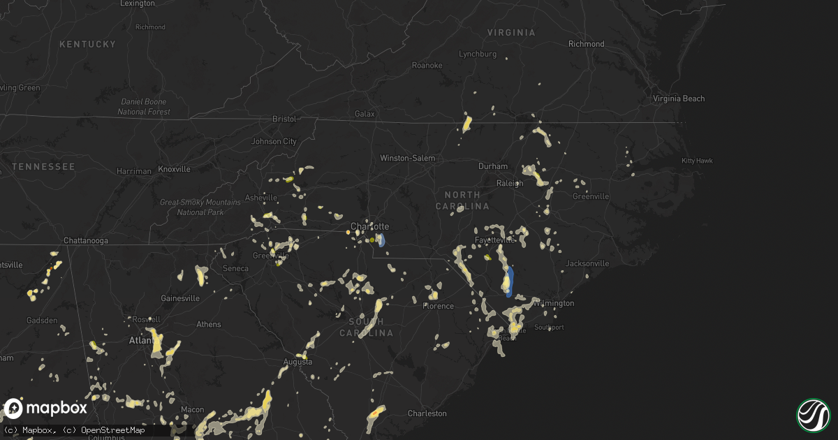
Hail Map in North Carolina on June 25, 2025
Get this storm
June 25 map
$229
one time, instant access
Download today. No call, no setup
Keep the $229
Bought the map and want the full workflow? Apply the entire $229 to a subscription within 7 days. None of it is wasted.
Every map, not just this one
This buys you this map. Subscription and you get every map we run, in the markets you choose from a few cities to whole states to nationwide. Plus real-time alerts the moment a storm fires.
Contact data
Name, contact info, occupancy, even credit band for addresses in the footprint. You go from where it hit to who to call.
Become the source they trust
Unlimited branding weather history reports on demand. You already have the documented answer ready for the property owner, and you are the one who showed up with it.
Property data and RoofTrace estimates
Pull up any address you have got, its value and the exact code rules for that jurisdiction, straight from One Click Code. Then RoofTrace estimates the squares, pitch, and roof value, priced the way you price.
Storm reports in North Carolina
North Carolina
| Date | Description |
|---|---|
| 06/25/20256:36 PM CDT | Social media picture of a tree down across powerlines in the paw creek area. |
| 06/25/20256:00 PM CDT | Trees down near intersection of nc 22 and nc 27. |
| 06/25/20255:45 PM CDT | Scattered outages due to fallen trees and/or utility lines from matthews to indian trail. Time estimated from radar. |
| 06/25/20255:29 PM CDT | Keqy asos. |
| 06/25/20255:25 PM CDT | Social media video of a tree down across a fence. |
| 06/25/20255:25 PM CDT | A number of trees downed in the nc 216 area. |
| 06/25/20255:25 PM CDT | Trees down across western hoke co along nc211 north of plank rd. |
| 06/25/20255:24 PM CDT | Trees down on dallas cherryville hwy & puetts chapel rd. Time estimated from radar. |
| 06/25/20255:20 PM CDT | Trees uprooted and/or snapped in vicinity of county line rd intersection with beattie rd. Minor roof damage to a barn. Time estimated. |
| 06/25/20255:20 PM CDT | Trees down near hwy 274 and dameron rd. |
| 06/25/20255:20 PM CDT | Tree down on house on cenco dr. Time estimated from radar. |
| 06/25/20255:17 PM CDT | Downed trees reported near the intersection of swamp fox highway east and indigo flats east. Time estimated by radar. |
| 06/25/20255:15 PM CDT | Relayed through facebook. |
| 06/25/20255:06 PM CDT | Downed trees reported near the intersection of pine level church road and ramsey ford road. Time estimated by radar. |
| 06/25/20255:02 PM CDT | Tree down on utility equipment. |
| 06/25/20255:00 PM CDT | Large trees and utility lines downed along laurel park rd. |
| 06/25/20254:59 PM CDT | Report from mping: quarter |
| 06/25/20254:52 PM CDT | Tree down on utility equipment. |
| 06/25/20254:46 PM CDT | Tree down on utility equipment. |
| 06/25/20254:45 PM CDT | Social media picture of trees down in the tryon area. |
| 06/25/20254:41 PM CDT | Social media picture of several trees down in the columbus area. |
| 06/25/20254:37 PM CDT | Utility lines downed along providence rd. |
| 06/25/20254:36 PM CDT | Tree down on utility equipment. |
| 06/25/20254:32 PM CDT | Report from mping: quarter |
| 06/25/20254:30 PM CDT | Tree down on road near columbus regional |
| 06/25/20254:30 PM CDT | Trees down in the etowah area. |
| 06/25/20254:25 PM CDT | Social media picture of dime to quarter size hail along duncan hill rd in hendersonville. |
| 06/25/20254:20 PM CDT | Trees and/or utility lines down causing outages. |
| 06/25/20254:16 PM CDT | Report from mping: quarter |
| 06/25/20254:15 PM CDT | Social media report of hail up to quarter size in the mountain home area. |
| 06/25/20254:14 PM CDT | Tree limbs and debris had to be removed from the road near bayfield rd. And gibson rd. |
| 06/25/20254:13 PM CDT | Tree across andrew jackson hwy... Near ida mill rd. |
| 06/25/20254:12 PM CDT | Trees and debris across west blvd... Between turnpike rd. And us 401 and also in the area of park cir. And peden st. |
| 06/25/20254:09 PM CDT | Several trees down around the forest city and bostic areas. |
| 06/25/20254:05 PM CDT | Trees down along dunn rd between spiveys corner and salemburg. |
| 06/25/20254:00 PM CDT | Trees and/or utility lines down causing outages. |
| 06/25/20253:58 PM CDT | Social media report of nickel to quarter size hail in the edneyville area. |
| 06/25/20253:55 PM CDT | Quarter size hail reported along burney road. |
| 06/25/20253:45 PM CDT | Roughly 20 trees down in elizabethtown. Time estimated via radar. |
| 06/25/20253:45 PM CDT | Multiple trees down in the area of mccoll rd.... Hasty rd.... Oakwood dr.... And sycamore ln. |
| 06/25/20253:45 PM CDT | Trees down across northern sampson co. |
| 06/25/20253:45 PM CDT | Quarter size hail reported along burney road. |
| 06/25/20253:34 PM CDT | Duplin county 911 center relays report of powerlines down on church street. Time estimated by radar. |
| 06/25/20253:34 PM CDT | Tree down across johns rd.... Between pond dr. And pea bridge rd. |
| 06/25/20253:33 PM CDT | Downed trees blocking hwy 70. |
| 06/25/20253:30 PM CDT | Numerous trees down in the county... Including some on johns rd/us 501. |
| 06/25/20253:30 PM CDT | Tree and/or utility line damage leading to outages. |
| 06/25/20253:25 PM CDT | Trees downed near fortune rd and us 64. |
| 06/25/20253:24 PM CDT | Tree down blocking both lanes of n. King st.... Between w. Bizzel st. And hillside ave. |
| 06/25/20253:16 PM CDT | Duke energy reported power outage caused by fallen trees damaging equipment. |
| 06/25/20253:14 PM CDT | Duke energy reported power outage caused by fallen trees damaging equipment. |
| 06/25/20253:10 PM CDT | Tree downed on a vehicle. |
| 06/25/20253:07 PM CDT | Social media report of hail up to quarter size just east of marion. |
| 06/25/20253:02 PM CDT | Trees down on nc 581 near strickland rd. |
| 06/25/20253:00 PM CDT | Trees down on utility equipment. |
| 06/25/20253:00 PM CDT | Trees down near hankins and yancey rds. |
| 06/25/20253:00 PM CDT | Persistent quarter size hail reported near wayne-sanderson farms in st. Pauls. |
| 06/25/20252:56 PM CDT | Trees down on nc 97. |
| 06/25/20252:50 PM CDT | A local report indicates 1.00 inch wind near 4 ENE Pilot |
| 06/25/20252:50 PM CDT | Trees down on us-64 near nash/franklin county line. |
| 06/25/20252:50 PM CDT | Trees down on power equipment. |
| 06/25/20252:43 PM CDT | Downed trees and power outages. |
| 06/25/20252:40 PM CDT | Tree and/or utility line damage near patricia rd. |
| 06/25/20252:38 PM CDT | Outages from storm damage near paint fork rd. |
| 06/25/20252:36 PM CDT | Corrects previous tstm wnd dmg report from 4 ese youngsville. Numerous trees down east of youngsville. |
| 06/25/20252:36 PM CDT | Multiple large pine trees down at 1300 tarboro rd. |
| 06/25/20252:30 PM CDT | Numerous trees down across northeastern nash co. |
| 06/25/20252:30 PM CDT | Trees down southwest of clinton. |
| 06/25/20252:30 PM CDT | A local report indicates 1.00 inch wind near Little Switzerland |
| 06/25/20252:24 PM CDT | Duke energy outage for 160 customers caused by damaged equipment from fallen trees or limbs. |
| 06/25/20252:22 PM CDT | Tree down on power lines on 2nd st. |
| 06/25/20252:20 PM CDT | Multiple trees down in goldsboro... Including at least one at 707 mulberry st. |
| 06/25/20252:20 PM CDT | Tree and utility line damage leading to outages. Time approximate. |
| 06/25/20252:10 PM CDT | One tree down. |
| 06/25/20251:56 PM CDT | Trees down and resulting power outages. |
| 06/25/20251:46 PM CDT | Trees down between essex and hollister per duke energy outage map. |
| 06/25/20251:40 PM CDT | Corrects previous tstm wnd dmg report from 5 n bat cave. Tree and/or utility line damage near patricia rd. |
| 06/25/20251:36 PM CDT | Numerous trees down east of youngsville. |
| 06/25/20251:32 PM CDT | Trees down near i-85 exit 214. |
| 06/25/20251:30 PM CDT | Trees down along nc 43. |
| 06/25/20251:10 PM CDT | Trees down near 158 bypass and frazier rd. |
| 06/25/20251:00 PM CDT | Trees reported down via social media reports near old ferrell road. |
| 06/24/202511:43 PM CDT | Tree down at the intersection of manual and hall roads near mayodan in rockingham county nc. |
| 06/24/202511:41 PM CDT | Tree down near intersection oi green meadow loop road and grooms road. |
| 06/24/202511:41 PM CDT | Corrects previous tstm wnd dmg report from 3 s lawsonville. Tree down near intersection of green meadow loop road and grooms road. |
| 06/24/202511:23 PM CDT | Tree down near intersection of case school road and nc-704. |
| 06/24/202511:23 PM CDT | Tree down on power lines. |
| 06/24/202511:19 PM CDT | Trees down in the yanceyville area. |
| 06/24/202511:00 PM CDT | Trees downed and shed roof blown off. |
| 06/24/202510:56 PM CDT | Trees down in blanch. |
| 06/24/202510:43 PM CDT | Tree down on power line along glovenia street. |
| 06/24/202510:37 PM CDT | Roof blown off mobile home. Four uninjured occupants displaced. Additionally... Tree and power pole downed on property. |
| 06/24/202510:34 PM CDT | Tree down near intersection of garrett road and nc-87. |
All States Impacted by Hail Map on June 25, 2025
Cities Impacted by Hail Map on June 25, 2025
- Romney, WV
- Madison, VA
- Pratts, VA
- Aroda, VA
- Rochelle, VA
- Purgitsville, WV
- Augusta, WV
- Capon Bridge, WV
- Norlina, NC
- Manson, NC
- Baskerville, VA
- Boydton, VA
- Warrenton, NC
- Knightdale, NC
- Macon, NC
- Raleigh, NC
- Hampstead, NC
- Smithfield, NC
- Sopchoppy, FL
- Henderson, NC
- Burgaw, NC
- Maple Hill, NC
- Marion, NC
- Newland, NC
- Clinton, NC
- Newton Grove, NC
- Beulaville, NC
- Princeton, NC
- Hosford, FL
- Tellico Plains, TN
- Greenville, FL
- Hollister, NC
- Goldsboro, NC
- Eagle Butte, SD
- Wakpala, SD
- Mobridge, SD
- Glenham, SD
- Mound City, SD
- Salemburg, NC
- Roseboro, NC
- Apalachicola, FL
- Herndon, VA
- Spruce Pine, NC
- Terre Haute, IN
- Zebulon, NC
- Bunn, NC
- Enfield, NC
- Louisburg, NC
- Moultrie, GA
- Hartsfield, GA
- Mount Olive, NC
- Whitakers, NC
- Fowler, IL
- Raeford, NC
- Sterling, VA
- Burnsville, NC
- Columbus, NE
- Monroe, NE
- Dunn, NC
- Pikeville, NC
- Clayton, IN
- Collettsville, NC
- Mooresville, IN
- Sims, NC
- Meigs, GA
- Lumber Bridge, NC
- Youngsville, NC
- Fayetteville, NC
- Turkey, NC
- Peyton, CO
- Calhan, CO
- Animas, NM
- Chantilly, VA
- Rose Hill, NC
- Wewahitchka, FL
- Lucama, NC
- Saint Pauls, NC
- Shannon, NC
- Kenansville, NC
- Magnolia, NC
- Warsaw, NC
- Perry, FL
- Reston, VA
- Fairfax, VA
- Centreville, VA
- Plainfield, IN
- Brazil, IN
- Stockville, NE
- Smithland, IA
- Glenmont, OH
- Brinkhaven, OH
- Killbuck, OH
- Bertrand, NE
- Loomis, NE
- Holdrege, NE
- Wilson, NC
- Fremont, NC
- Kenly, NC
- Port Saint Joe, FL
- Wake Forest, NC
- Pasadena, MD
- Millersville, MD
- Hinton, VA
- Harrisonburg, VA
- Bristol, FL
- Tallahassee, FL
- West Point, NE
- Wisner, NE
- Dodge, NE
- Rolesville, NC
- Indianapolis, IN
- Greenwood, IN
- Oakland, NE
- Middlesex, NC
- Bessemer, AL
- Oto, IA
- Mapleton, IA
- Bailey, NC
- Bolivia, NC
- Winnabow, NC
- Mulga, AL
- Boaz, AL
- Albertville, AL
- Beemer, NE
- Spring Hope, NC
- Wilmington, NC
- Crossville, AL
- Colorado Springs, CO
- Carbon, IN
- Fyffe, AL
- Geraldine, AL
- Nebo, NC
- White Oak, NC
- Hope Mills, NC
- Central City, NE
- Platte Center, NE
- Wendell, NC
- Los Alamos, NM
- Circle, MT
- Red Springs, NC
- Maxton, NC
- Fairfax Station, VA
- Verbena, AL
- Lamont, FL
- Faison, NC
- Atlanta, NE
- Broken Bow, NE
- Callaway, NE
- Eustis, NE
- Elwood, NE
- Funston, GA
- Elm Creek, NE
- Funk, NE
- Kearney, NE
- Riverdale, NE
- Odessa, NE
- Axtell, NE
- Pleasanton, NE
- Ravenna, NE
- Minden, NE
- Gibbon, NE
- Wagram, NC
- Casper, WY
- Danbury, IA
- Elm City, NC
- Barnardsville, NC
- Thurmont, MD
- Rocky Ridge, MD
- Emmitsburg, MD
- Severna Park, MD
- Crownsville, MD
- Sale City, GA
- Alden, MN
- Doerun, GA
- District Heights, MD
- Suitland, MD
- Capitol Heights, MD
- Upper Marlboro, MD
- Andrews Air Force Base, MD
- Clinton, MD
- Brandywine, MD
- Cheltenham, MD
- Wellington, CO
- Carr, CO
- Craig, NE
- Laurinburg, NC
- Campbell, NE
- Schuyler, NE
- Holstein, NE
- Ramah, CO
- Grand Island, NE
- Tar Heel, NC
- Elizabethtown, NC
- Kenesaw, NE
- Shelton, NE
- Chapman, NE
- Gillette, WY
- Brockway, MT
- Clarkton, NC
- Bladenboro, NC
- Hartland, MN
- Cozad, NE
- Lexington, NE
- Autryville, NC
- Nunn, CO
- Pittsboro, IN
- North Salem, IN
- Danville, IN
- Lizton, IN
- Section, AL
- Sylacauga, AL
- Weogufka, AL
- Spencer, TN
- Crawfordville, FL
- Cheyenne, WY
- Wade, NC
- Stedman, NC
- Marston, NC
- Spring Valley, MN
- Ostrander, MN
- Coalmont, TN
- Gruetli Laager, TN
- Tracy City, TN
- Havana, FL
- Washington, DC
- Ashton, NE
- Farwell, NE
- Boelus, NE
- Dannebrog, NE
- Cairo, NE
- Saint Paul, NE
- Rockville, NE
- Elba, NE
- Wood River, NE
- Whiteville, NC
- Delco, NC
- Godwin, NC
- Rowland, NC
- Hallsboro, NC
- Asheville, NC
- Plymouth, IL
- Hill City, SD
- Laurel Hill, NC
- Jordan, MT
- Saint Marks, FL
- Panama City, FL
- Bainbridge, GA
- Bellevue, OH
- Monroeville, OH
- Willard, OH
- Norwalk, OH
- North Fairfield, OH
- Forest City, NC
- Bostic, NC
- Lawndale, NC
- Dutton, AL
- Pisgah, AL
- Scotia, NE
- Wolbach, NE
- Magdalena, NM
- Alzada, MT
- Greeley, NE
- Buckhannon, WV
- Gibson, NC
- Henagar, AL
- Flat Rock, AL
- Inlet Beach, FL
- Lake Waccamaw, NC
- Bolton, NC
- Linden, NC
- Dunlap, TN
- Ash, NC
- Fairmont, NC
- Hamer, SC
- Bowling Green, FL
- Wauchula, FL
- Chipley, FL
- Youngstown, FL
- Faribault, MN
- Kenyon, MN
- Spalding, NE
- Charlotte, NC
- Waxhaw, NC
- Matthews, NC
- Primrose, NE
- Ebro, FL
- Clarks, NE
- Silver Creek, NE
- Rozet, WY
- Stevenson, AL
- Hendersonville, NC
- Sneads Ferry, NC
- Jacksonville, NC
- Palmer, TN
- Heartwell, NE
- Hornick, IA
- Rodney, IA
- Santa Rosa Beach, FL
- Pisgah Forest, NC
- Panama City Beach, FL
- Spindale, NC
- Phillips, NE
- Doniphan, NE
- Lake View, SC
- Pensacola, FL
- Flat Rock, NC
- Grand Mound, IA
- Moorcroft, WY
- De Witt, IA
- Dodge Center, MN
- Charlotte, IA
- Delmar, IA
- Goose Lake, IA
- Rushford, MN
- Houston, MN
- Blountstown, FL
- Milton, FL
- Saluda, NC
- Vass, NC
- Penrose, NC
- Leland, NC
- Bennettsville, SC
- Orrum, NC
- Moatsville, WV
- Spring Lake, NC
- Pope Army Airfield, NC
- Fort Bragg, NC
- Fair Bluff, NC
- Nichols, SC
- Mullins, SC
- Loris, SC
- Green Sea, SC
- Clinton, IA
- Fulton, IL
- Marianna, FL
- Cottondale, FL
- Belle Fourche, SD
- Rapid City, SD
- Keystone, SD
- Conway, SC
- Genoa, NE
- North Myrtle Beach, SC
- Little River, SC
- Calabash, NC
- Sunset Beach, NC
- Blenheim, SC
- Darlington, SC
- Longs, SC
- Beersheba Springs, TN
- Cherryville, NC
- Bessemer City, NC
- Kings Mountain, NC
- Clarion, IA
- Eagle Grove, IA
- Lancaster, SC
- Fort Payne, AL
- Valley Head, AL
- Rutherfordton, NC
- Woodrow, CO
- Monroe, NC
- Baker, MT
- Upton, WY
- Glenrock, WY
- Carolina Beach, NC
- Myrtle Beach, SC
- Shelby, NC
- Quincy, FL
- Aquasco, MD
- Horse Shoe, NC
- Kershaw, SC
- Sundance, WY
- Caledonia, MN
- Hokah, MN
- Clover, SC
- Gastonia, NC
- Crestview, FL
- Pikeville, TN
- South Boston, VA
- Crossville, TN
- Douglas, WY
- Gaffney, SC
- Nakina, NC
- Pineville, NC
- Fort Mill, SC
- Clewiston, FL
- South Bay, FL
- De Graff, OH
- Indian Trail, NC
- Tiffin, OH
- Green Springs, OH
- Wheatland, WY
- Carthage, NC
- Union Springs, AL
- Huntingtown, MD
- Mobile, AL
- Rhame, ND
- Camp Crook, SD
- Lake City, MN
- Simpsonville, SC
- Wabasha, MN
- Travelers Rest, SC
- Arcadia, SC
- Spartanburg, SC
- Zirconia, NC
- Sparta, TN
- Quebeck, TN
- Doyle, TN
- Inman, SC
- Greer, SC
- Tabor City, NC
- Santa Fe, NM
- Boiling Springs, SC
- Wabash, IN
- Urbana, IN
- Lagro, IN
- Wall, SD
- Quinn, SD
- Kadoka, SD
- La Crosse, WI
- Bangor, WI
- Wellford, SC
- Cleveland, SC
- Nemaha, IA
- Brevard, NC
- Chattahoochee, FL
- Duncan, SC
- Startex, SC
- Taylors, SC
- Ocean Isle Beach, NC
- Longwood, NC
- Lyman, SC
- Buffalo, SD
- Lagrange, WY
- Mcminnville, TN
- Greenville, SC
- Monticello, FL
- Boston, GA
- Hartsville, SC
- Pickens, SC
- South Charleston, OH
- Lamar, SC
- Marietta, SC
- Eitzen, MN
- Albany, GA
- Nesmith, SC
- Kingstree, SC
- Vernon, FL
- Society Hill, SC
- Oak Island, NC
- Jefferson, SC
- Una, SC
- Mauldin, SC
- Cades, SC
- York, SC
- Fort Collins, CO
- Southport, NC
- Easley, SC
- Clarendon, NC
- Bremen, GA
- Waco, GA
- Bishopville, SC
- McBee, SC
- Dixie, GA
- Fitzgerald, GA
- Winnsboro, SC
- Liberty Hill, SC
- Ridgeway, SC
- Belmont, NC
- Sylvester, GA
- Rock Hill, SC
- Summerfield, OH
- Sarahsville, OH
- Sumner, GA
- Carrollton, GA
- Thomasville, GA
- Shallotte, NC
- Terry, MT
- Alford, FL
- Timmonsville, SC
- Fountain, FL
- Knox, IN
- Fork, SC
- Supply, NC
- Clinton, SC
- Laurens, SC
- Lugoff, SC
- Elgin, SC
- Blackstock, SC
- Chester, SC
- Leesburg, GA
- Wenona, IL
- Waelder, TX
- Rosanky, TX
- Altha, FL
- Camden, SC
- Brinson, GA
- Williamsburg, NM
- Dayton, VA
- Columbia, SC
- Eastover, SC
- Hopkins, SC
- Rockton, IL
- Rockford, IL
- South Beloit, IL
- Roscoe, IL
- Beloit, WI
- Clinton, WI
- Bascom, FL
- Greenwood, FL
- Bagdad, FL
- Grand Ridge, FL
- Mountain Rest, SC
- Janesville, WI
- Archer, NE
- Early, IA
- Newell, IA
- Whitmire, SC
- Carlisle, SC
- Blair, SC
- Ochlocknee, GA
- Donalsonville, GA
- Sanford, NC
- Robbins, NC
- Littleton, NC
- Arcadia, OH
- Pavo, GA
- Pelham, GA
- Dillon, SC
- Great Falls, SC
- Seven Springs, NC
- North Augusta, SC
- Campbellton, FL
- Monessen, PA
- Monongahela, PA
- Donora, PA
- Bowman, SC
- Colerain, NC
- Philippi, WV
- Boncarbo, CO
- Weston, CO
- Trinidad, CO
- Clayton, GA
- Graniteville, SC
- Warrenville, SC
- Beech Island, SC
- Cleveland, GA
- Winston, NM
- Chugwater, WY
- Aynor, SC
- Graceville, FL
- Salem, SC
- Walhalla, SC
- Rowesville, SC
- Branchville, SC
- Longmont, CO
- Erie, CO
- Merry Hill, NC
- Slocomb, AL
- Leary, GA
- Damascus, GA
- Plymouth, NC
- Windsor, NC
- Yemassee, SC
- Walterboro, SC
- Roswell, GA
- Blakely, GA
- Arlington, GA
- Murrayville, GA
- Marquette, NE
- Tallmansville, WV
- Gresham, SC
- Lewisville, OH
- Newberry, SC
- Mount Croghan, SC
- Fort Peck, MT
- Silverstreet, SC
- Tuskegee, AL
- Montgomery, AL
- Tallapoosa, GA
- Appomattox, VA
- Pamplin, VA
- Wetumpka, AL
- Windsor, IL
- Alpharetta, GA
- Smithton, PA
- Sautee Nacoochee, GA
- Baconton, GA
- Westminster, CO
- Arvada, CO
- Denver, CO
- Commerce City, CO
- Greenwich, OH
- Chapin, SC
- Irmo, SC
- Florence, SC
- Abbeville, GA
- Castana, IA
- Cairo, GA
- Republic, OH
- Attica, OH
- Kennesaw, GA
- Ridge Spring, SC
- Danville, OH
- Lower Salem, OH
- Richburg, SC
- Whigham, GA
- Aurora, CO
- Dacono, CO
- Thornton, CO
- Brighton, CO
- Henderson, CO
- Firestone, CO
- Bonifay, FL
- Fort Gaines, GA
- Mill Hall, PA
- Beech Creek, PA
- Lafayette, CO
- Raton, NM
- Clarkesville, GA
- Gaston, SC
- Swansea, SC
- Trenton, SC
- Aiken, SC
- Johnston, SC
- Macclesfield, NC
- Pinetops, NC
- Camilla, GA
- Rockford, AL
- Oshkosh, NE
- Deming, NM
- Goldfield, IA
- Victoria, VA
- Sac City, IA
- Fonda, IA
- Marbury, AL
- La Junta, CO
- Las Animas, CO
- Fountain, NC
- Hillsboro, NM
- Laurel, MS
- Trinchera, CO
- Branson, CO
- Mount Airy, GA
- Ruffin, SC
- Horseshoe Beach, FL
- Truth Or Consequences, NM
- Climax, GA
- Early Branch, SC
- Seminole, FL
- Saint Petersburg, FL
- Demorest, GA
- Coolidge, GA
- Defuniak Springs, FL
- Seale, AL
- Rocky Mount, NC
- Cornelia, GA
- Hartford, AL
- Baldwin, GA
- Marion, AL
- Pittsview, AL
- Elba, AL
- Witt, IL
- Fallon, MT
- Irving, IL
- Indian Rocks Beach, FL
- Shorterville, AL
- Clearwater, FL
- Pinellas Park, FL
- Largo, FL
- Newton, GA
- Zolfo Springs, FL
- Colquitt, GA
- Inglis, FL
- Dunnellon, FL
- Augusta, GA
- Laurel Hill, FL
- Crystal River, FL
- Fowler, IN
- Rockmart, GA
- Temple, GA
- Brundidge, AL
- Jack, AL
- Dahlonega, GA
- Toccoa, GA
- Cassatt, SC
- Poulan, GA
- Florala, AL
- Cottonwood, AL
- Malone, FL
- Luverne, AL
- Gordon, GA
- Gilbert, SC
- Blythe, GA
- Ariton, AL
- Little Mountain, SC
- Opp, AL
- Covington, GA
- Oxford, GA
- Foxworth, MS
- Tylertown, MS
- Louisville, GA
- Westville, FL
- State Line, MS
- Columbia, AL
- Jeffersonville, GA
- Bartow, GA
- Aurora, NE
- Glendive, MT
- Kettle Falls, WA
- Oakfield, GA
- Atlanta, GA
- Clarkston, GA
- Tucker, GA
- Decatur, GA
- Stone Mountain, GA
- Conyers, GA
- Dry Branch, GA
- Wadley, GA
- Dothan, AL
- Springer, NM
- Mcdonough, GA
- Dunedin, FL
- Palm Harbor, FL
- Poplar, MT
- Tarboro, NC
- Centreville, AL
- Eagle Springs, NC
- Renwick, IA
- Clio, AL
- Thomaston, GA
- Manchester, GA
- Woodbury, GA
- Molena, GA
- Abbeville, AL
- Lithonia, GA
- Ellenwood, GA
- Smoaks, SC
- Louisville, AL
- Clayton, AL
- Stockbridge, GA
- Wrightsville, GA
- Harrison, GA
- Pine Lake, GA
- Scottdale, GA
- Avondale Estates, GA
- Eight Mile, AL
- Kokomo, MS
- Giltner, NE
- De Soto, GA
- Chancellor, AL
- Ashford, AL
- Monetta, SC
- Warm Springs, GA
- Theodore, AL
- Cordele, GA
- Cobb, GA
- Holt, FL
- Baker, FL
- Hartwell, GA
- Bowersville, GA
- Eglin Afb, FL
- Gantt, AL
- Jacksonville, GA
- Lock Haven, PA
- Bronwood, GA
- Newton, AL
- Midland City, AL
- Milan, GA
- Rhine, GA
- Leslie, GA
- Dawson, GA
- Ashburn, GA
- Monticello, MS
- Newellton, LA
- Whitesburg, GA
- Vienna, GA
- Greenville, NC
- Canon, GA
- Royston, GA
- Jayess, MS
- Rainsville, AL
- Woodland, GA
- Evant, TX
- Hamilton, TX
- Sardis, OH
- Clarington, OH
- Nashville, NC
- Warwick, GA
- Norway, SC
- Halifax, VA
- Americus, GA
- Byromville, GA
- Williston, SC
- Blackville, SC
- Villa Rica, GA
- Raymond, MS
- Kite, GA
- Caldwell, OH
- Selma, AL
- Jackson, SC
- Barnwell, SC
- Millbrook, AL
- Prattville, AL
- Matthews, GA
- Byram, MS
- Hephzibah, GA
- Camden, AL
- Adrian, GA
- Vancleave, MS
- Danville, VA
- Ringgold, VA
- Rockledge, GA
- Highland Home, AL
- Pinehurst, GA
- Pitts, GA
- Milton, NC
- Blanch, NC
- Providence, NC
- Sutherlin, VA
- Yanceyville, NC
- Wrens, GA
- Lucedale, MS
- Vinegar Bend, AL
- Fruitdale, AL
- Rochelle, GA
- Deatsville, AL
- Blairs, VA
- Dublin, GA
- Avera, GA
- Preston, GA
- Richland, GA
- Homosassa, FL
- Safety Harbor, FL
- Lumpkin, GA
- Omaha, GA
- Platteville, CO
- Fort Mitchell, AL
- Cape Coral, FL
- North Fort Myers, FL
- Davisboro, GA
- Fairfield, AL
- Arabi, GA
- Deer Park, AL
- Chatom, AL
- Catherine, AL
- Autaugaville, AL
- Billingsley, AL
- Linden, AL
- Eufaula, AL
- Wray, GA
- Jones, AL
- Luling, TX
- Albany, OH
- Edwards, MS
- Utica, MS
- Tibbie, AL
- McIntosh, AL
- Wagarville, AL
- Sandersville, GA
- Hardaway, AL
- Birmingham, AL
- Waynesboro, GA
- Shorter, AL
- Marshallville, GA
- Grant, NE
- Madrid, NE
- Loveland, CO
- Acworth, GA
- Cross City, FL
- Montezuma, GA
- Elko, GA
- Perry, GA
- Holyoke, CO
- Fort Valley, GA
- Leakesville, MS
- Thomaston, AL
- Sylvania, GA
- Ty Ty, GA
- Marietta, GA
- Tuscumbia, AL
- Leighton, AL
- Millen, GA
- Junction City, GA
- Portal, GA
- Tennille, GA
- Plantersville, AL
- Gretna, VA
- McRae Helena, GA
- Duck, WV
- Nebo, WV
- Roberta, GA
- Clanton, AL
- New Martinsville, WV
- Proctor, WV
- Statesboro, GA
- Bonaire, GA
- Locust Grove, GA
- Cochran, GA
- Reynolds, GA
- Dawson, AL
- New Port Richey, FL
- Tarpon Springs, FL
- Newington, GA
- Kathleen, GA
- Byron, GA
- Akron, AL
- Moundville, AL
- Greensboro, AL
- Ridgeland, SC
- Sheldon, SC
- Lecanto, FL
- Port Richey, FL
- Guntersville, AL
- Collinsville, AL
- Warner Robins, GA
- Toomsboro, GA
- Loganville, GA
- Fosters, AL
- East Dublin, GA
- Danville, GA
- Barnesville, GA
- Macon, GA
- Forsyth, GA
- Brooklet, GA
- Guyton, GA
- Lizella, GA
- Unadilla, GA
- Hawkinsville, GA
- Dudley, GA
- Dexter, GA
- Glenwood, GA
- Claxton, GA
- West Blocton, AL
- Pineview, GA
- Brierfield, AL
- Tuscaloosa, AL
- Old Town, FL
- Montrose, GA
- Colona, IL
- Julesburg, CO
- Venango, NE
- Athens, TN
- Geneseo, IL
- Woodstock, AL
- Vance, AL
- Manchester, TN
- Chester, GA
- Talladega, AL
- Buhl, AL
- Tullahoma, TN
- Irwinton, GA
- Thorsby, AL
- Culloden, GA
- Yatesville, GA
- Munford, AL
- Rex, GA
- Cragford, AL
- Ashland, AL
- Lineville, AL
- Franklin, GA
- Eastman, GA
- Hazlehurst, GA
- Alma, GA
- Dozier, AL
- Fort Davis, AL
- Lagrange, GA
- Greenville, GA
- Butler, GA
- Pine Mountain, GA
- Smithville, GA
- Hogansville, GA
- Bowdon, GA
- Pelham, NC
- Newman Grove, NE
- Five Points, AL
- Elon, NC
- Burlington, NC
- Fairmont, WV
- Fairview, WV
- Chula, GA
- Piedmont, AL
- Register, GA
- Metter, GA
- Jackson, OH
- Nicholls, GA
- Rebecca, GA
- Lumber City, GA
- Lusk, WY
- Jackson, GA
- Fayetteville, GA
- Hampton, GA
- Alamo, GA
- Windsor, CO
- Cope, CO
- Baxley, GA
- Griffin, GA
- Fairview, NC
- Black Mountain, NC
- Jonesboro, GA
- Broomfield, CO
- Westby, WI
- Carbon Hill, AL
- Townley, AL
- Rockland, WI
- Jemison, AL
- Carnesville, GA
- Coker, AL
- Northport, AL
- York, AL
- La Farge, WI
- Ontario, WI
- Cashton, WI
- Dix, NE
- Ralph, AL
- Eutaw, AL
- Knoxville, AL
- Hammond, MT
- Demopolis, AL
- Parrish, AL
- Punta Gorda, FL
- Fort Myers, FL
- New London, OH
- Clyde, OH
- Vickery, OH
- Fremont, OH
- Roanoke, AL
- Tampa, FL
- Lafayette, AL
- Berthoud, CO
- Jacksonville, AL
- Lanett, AL
- Haleyville, AL
- Fort Lupton, CO
- Frederick, CO
- Bridgewater, VA
- Mount Solon, VA
- Weyers Cave, VA
- Mount Sidney, VA
- Calamus, IA
- Gloverville, SC
- Wellston, OH
- Pomeroy, OH


