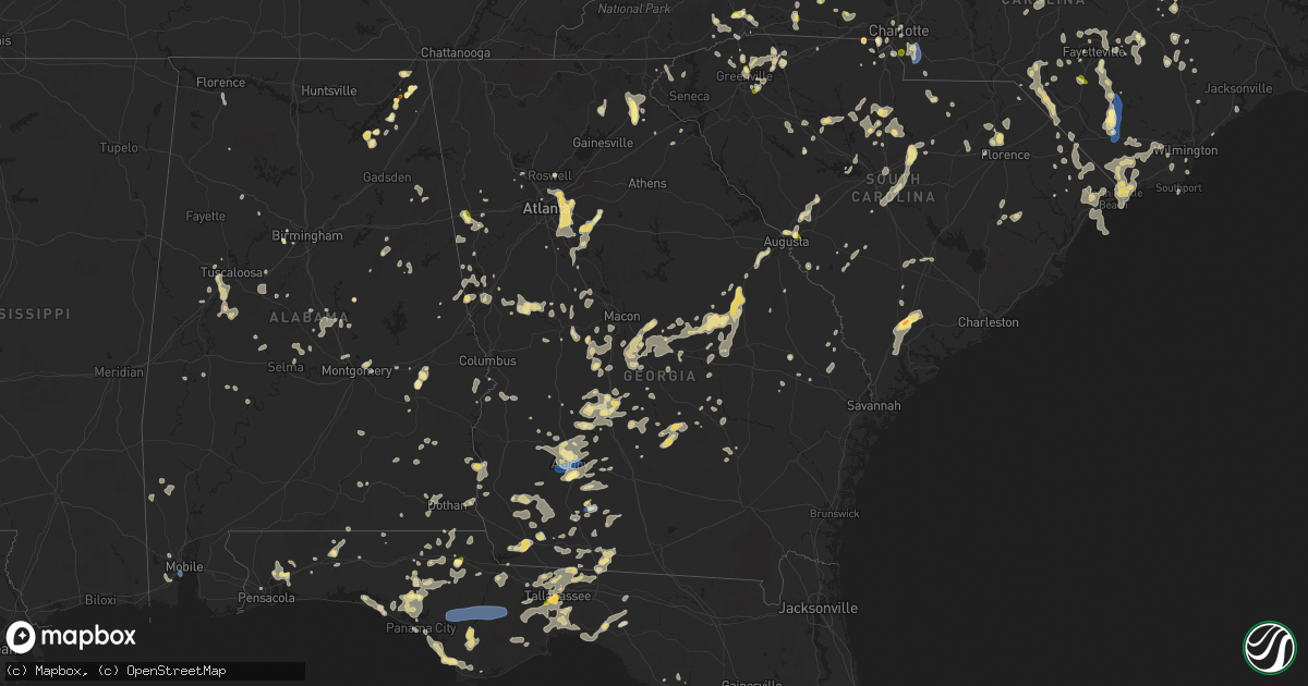
Hail Map in Georgia on June 25, 2025
Get this storm
June 25 map
$229
one time, instant access
Download today. No call, no setup
Keep the $229
Bought the map and want the full workflow? Apply the entire $229 to a subscription within 7 days. None of it is wasted.
Every map, not just this one
This buys you this map. Subscription and you get every map we run, in the markets you choose from a few cities to whole states to nationwide. Plus real-time alerts the moment a storm fires.
Contact data
Name, contact info, occupancy, even credit band for addresses in the footprint. You go from where it hit to who to call.
Become the source they trust
Unlimited branding weather history reports on demand. You already have the documented answer ready for the property owner, and you are the one who showed up with it.
Property data and RoofTrace estimates
Pull up any address you have got, its value and the exact code rules for that jurisdiction, straight from One Click Code. Then RoofTrace estimates the squares, pitch, and roof value, priced the way you price.
Storm reports in Georgia
Georgia
| Date | Description |
|---|---|
| 06/25/20256:00 PM CDT | Power lines reported down in cairo. |
| 06/25/20253:46 PM CDT | A local report indicates 1.00 inch wind near 1 SE Poplar Arbor Churc |
| 06/25/20253:22 PM CDT | Measured with rooftop anemometer. |
| 06/25/202511:15 AM CDT | Tree limbs on sr 18 both directions at balls church rd. All lanes closed. |
| 06/25/202511:10 AM CDT | Tree limbs on sr 26 both directions at lawton smith rd near adrian... Ga. All lanes closed. |
| 06/25/20251:35 AM CDT | 511ga reported tree limb on sr 520 eastbound at |
| 06/25/20251:35 AM CDT | 511ga reported tree limb |
| 06/25/202512:15 AM CDT | The emergency manager relayed a rep |
| 06/25/202512:15 AM CDT | Tree limbs on sr 7 northbound at thomaston st. All lanes closed. |
| 06/25/202512:15 AM CDT | The emergency manager relayed a report of a downed tree on old zebulon road near highway 109. |
| 06/25/202512:15 AM CDT | The emergency manager relayed a report of a downed tree on old zebulon road ne |
| 06/25/202512:15 AM CDT | Tree limbs on sr 7 northbound at tho |
| 06/25/202512:15 AM CDT | Tree limbs on sr 7 northbound at thomaston s |
| 06/25/202512:15 AM CDT | Tree l |
| 06/25/202512:09 AM CDT | The ham radio coordinator for upson |
| 06/25/202512:09 AM CDT | The ham radio co |
| 06/25/202512:09 AM CDT | The ham radio coordinator for upson county reports multiple trees blocking atwater rd between willingham springs rd and weems rd. |
| 06/24/202511:56 PM CDT | The emergency manager relayed a report of a tree down in the 7600 block of highway 16/newnan road. |
| 06/24/202511:56 PM CDT | The emergency manager relayed a report of a tree down in the 7600 block of highway 16/newnan ro |
| 06/24/202511:56 PM CDT | Tree downed across 300 block of anderson road. |
| 06/24/202511:45 PM CDT | Public reported a couple trees down at a location of elberta drive. |
| 06/24/202511:44 PM CDT | Tree downed across redwine road. |
| 06/24/202511:42 PM CDT | Tree downed across old greenville road south of goza road. |
| 06/24/202511:40 PM CDT | Trees downed near the intersection of hampton road and ga92. |
| 06/24/202511:35 PM CDT | Several trees and a power pole snapped near the intersection of hwy 74 and 54. |
| 06/24/202511:34 PM CDT | The emergency manager relayed a report of a downed tree in the 800 block of west wall street. |
| 06/24/202511:28 PM CDT | Public reported a tree down on a house on wilmington lane. |
| 06/24/202511:27 PM CDT | The emergency manager relayed a report of a |
| 06/24/202511:27 PM CDT | The emergency manager relayed a report of a tree and powerlines down along the 1900 block of north hill street ext. |
| 06/24/202511:27 PM CDT | Tree downed across burroughs avenue. |
| 06/24/202511:24 PM CDT | Public reported numerous trees down and fence damage along lost court in hampton. Radar indicates a downburst in the area likely produced 75-80 mph winds... Causing the |
| 06/24/202511:20 PM CDT | Large tree down on a house off thornwood court. |
| 06/24/202511:16 PM CDT | The emergency manager relayed a report of a tree down in the 4400 block of jackson road. |
| 06/24/202511:14 PM CDT | The emergency manager relayed a report of a downed tree in the 600 block of wallace road. |
| 06/24/202511:13 PM CDT | A tree was blown onto a shed on navaho road. |
| 06/24/202511:11 PM CDT | The emergency manager relayed a report of three trees down along the 1600 and 1700 blocks of locust grove road. |
| 06/24/202511:10 PM CDT | A 911 call center reported a tree down along carson sands rd. Time was estimated via radar data. |
| 06/24/202511:10 PM CDT | Public reported a powerline down along the 1100 block of millers mill road. |
| 06/24/202511:08 PM CDT | The emergency manager relayed a report of a tree down in the 300 block of east anderson road. |
| 06/24/202511:08 PM CDT | Tree down on wilton threatt road. Time estimated from radar. |
| 06/24/202511:08 PM CDT | Tree down on burkhalter drive. Time estimated by radar. |
| 06/24/202511:05 PM CDT | Tree limbs were on sr 90 both directions at dewey mcglamry rd blocking both lanes. |
| 06/24/202511:01 PM CDT | A 911 call center reported a tree down near the intersection of barrow bay and leah rd. Time was estimated via radar data. |
| 06/24/202511:01 PM CDT | Tree down on burkhalter drive. Time estimated by radar. |
| 06/24/202511:01 PM CDT | Tree down on wilton threatt road. Time estimated from radar. |
| 06/24/202511:01 PM CDT | Tree down on the intersection of se broad street and lillian street. Time estimated from radar. |
| 06/24/202510:58 PM CDT | A 911 call center reported a tree down near the intersection of barrow bay and leah rd. Time was estimated via radar data. |
| 06/24/202510:58 PM CDT | A 911 call center reported a tree down along shady oak ln. Time was estimated via radar data. |
| 06/24/202510:55 PM CDT | Tree down on the intersection of se broad street and lillian street. Time estimated from radar. |
| 06/24/202510:37 PM CDT | Tree down on brooklet- leefield rd at clito rd. Time estimated from radar. |
| 06/24/202510:36 PM CDT | Tree limbs on sr 19 both directions at durham mill rd. All lanes closed. |
| 06/24/202510:34 PM CDT | Tree down on cowboy way. Time estimated from radar. |
| 06/24/202510:29 PM CDT | Tree down on old river rd n and highway 301. Time estimated from radar. |
| 06/24/202510:05 PM CDT | Burke county em reported trees down blocking roadway at lake eleanor road and gough spur road. Time estimated by radar. |
| 06/24/20259:59 PM CDT | Multiple treees down on mims road. Time estimated from radar. |
| 06/24/20259:59 PM CDT | Multiple trees down on south maine. Time estimated from radar. |
| 06/24/20259:45 PM CDT | Burke county em reported trees down on powerlines along joyner oglesby road. Time estimated by radar. |
| 06/24/20259:23 PM CDT | Power lines down along ben arthur rd. |
| 06/24/20259:10 PM CDT | Report from emergency management of 3 trees down in northern banks county. |
| 06/24/20258:41 PM CDT | Quarter sized hail lasted a few seconds. |
| 06/24/20258:37 PM CDT | Trees blown down east of demorest. |
| 06/24/20258:35 PM CDT | Viewer report of pea to quarter size hail in lee county. |
| 06/24/20258:34 PM CDT | Social media report of hail up to quarter size in royston. |
| 06/24/20258:30 PM CDT | Tree blown down on a personal property along lumpkin road. |
| 06/24/20258:28 PM CDT | Tree down along the orchard road. |
| 06/24/20258:17 PM CDT | 911 dispatch reports numerous trees and powerlines down on hwy 197 between batesville and dicks hill pkwy. |
| 06/24/20258:07 PM CDT | Tree down and blocking the roadway at westmoreland rd near smith rd. |
| 06/24/20258:07 PM CDT | Reported at kaby asos. |
| 06/24/20258:05 PM CDT | Hail damaged the roof then water started to leak into the attic. |
| 06/24/20258:00 PM CDT | Trees downed along linda lane on the north side of carrollton. |
| 06/24/20257:45 PM CDT | Tree limbs on sr 200 eastbound at waller rd. Right lane blocked. |
| 06/24/20257:30 PM CDT | Quarter-sized hail reported in waco. |
| 06/24/20257:30 PM CDT | Corrects previous hail report from waco. Quarter-sized hail reported in waco. |
| 06/24/20257:17 PM CDT | Report of 1 inch hail near putney. |
| 06/24/20257:15 PM CDT | Several trees and power lines down in miller county. |
| 06/24/20257:00 PM CDT | Two trees down in baker county. |
All States Impacted by Hail Map on June 25, 2025
Cities Impacted by Hail Map on June 25, 2025
- Romney, WV
- Madison, VA
- Pratts, VA
- Aroda, VA
- Rochelle, VA
- Purgitsville, WV
- Augusta, WV
- Capon Bridge, WV
- Norlina, NC
- Manson, NC
- Baskerville, VA
- Boydton, VA
- Warrenton, NC
- Knightdale, NC
- Macon, NC
- Raleigh, NC
- Hampstead, NC
- Smithfield, NC
- Sopchoppy, FL
- Henderson, NC
- Burgaw, NC
- Maple Hill, NC
- Marion, NC
- Newland, NC
- Clinton, NC
- Newton Grove, NC
- Beulaville, NC
- Princeton, NC
- Hosford, FL
- Tellico Plains, TN
- Greenville, FL
- Hollister, NC
- Goldsboro, NC
- Eagle Butte, SD
- Wakpala, SD
- Mobridge, SD
- Glenham, SD
- Mound City, SD
- Salemburg, NC
- Roseboro, NC
- Apalachicola, FL
- Herndon, VA
- Spruce Pine, NC
- Terre Haute, IN
- Zebulon, NC
- Bunn, NC
- Enfield, NC
- Louisburg, NC
- Moultrie, GA
- Hartsfield, GA
- Mount Olive, NC
- Whitakers, NC
- Fowler, IL
- Raeford, NC
- Sterling, VA
- Burnsville, NC
- Columbus, NE
- Monroe, NE
- Dunn, NC
- Pikeville, NC
- Clayton, IN
- Collettsville, NC
- Mooresville, IN
- Sims, NC
- Meigs, GA
- Lumber Bridge, NC
- Youngsville, NC
- Fayetteville, NC
- Turkey, NC
- Peyton, CO
- Calhan, CO
- Animas, NM
- Chantilly, VA
- Rose Hill, NC
- Wewahitchka, FL
- Lucama, NC
- Saint Pauls, NC
- Shannon, NC
- Kenansville, NC
- Magnolia, NC
- Warsaw, NC
- Perry, FL
- Reston, VA
- Fairfax, VA
- Centreville, VA
- Plainfield, IN
- Brazil, IN
- Stockville, NE
- Smithland, IA
- Glenmont, OH
- Brinkhaven, OH
- Killbuck, OH
- Bertrand, NE
- Loomis, NE
- Holdrege, NE
- Wilson, NC
- Fremont, NC
- Kenly, NC
- Port Saint Joe, FL
- Wake Forest, NC
- Pasadena, MD
- Millersville, MD
- Hinton, VA
- Harrisonburg, VA
- Bristol, FL
- Tallahassee, FL
- West Point, NE
- Wisner, NE
- Dodge, NE
- Rolesville, NC
- Indianapolis, IN
- Greenwood, IN
- Oakland, NE
- Middlesex, NC
- Bessemer, AL
- Oto, IA
- Mapleton, IA
- Bailey, NC
- Bolivia, NC
- Winnabow, NC
- Mulga, AL
- Boaz, AL
- Albertville, AL
- Beemer, NE
- Spring Hope, NC
- Wilmington, NC
- Crossville, AL
- Colorado Springs, CO
- Carbon, IN
- Fyffe, AL
- Geraldine, AL
- Nebo, NC
- White Oak, NC
- Hope Mills, NC
- Central City, NE
- Platte Center, NE
- Wendell, NC
- Los Alamos, NM
- Circle, MT
- Red Springs, NC
- Maxton, NC
- Fairfax Station, VA
- Verbena, AL
- Lamont, FL
- Faison, NC
- Atlanta, NE
- Broken Bow, NE
- Callaway, NE
- Eustis, NE
- Elwood, NE
- Funston, GA
- Elm Creek, NE
- Funk, NE
- Kearney, NE
- Riverdale, NE
- Odessa, NE
- Axtell, NE
- Pleasanton, NE
- Ravenna, NE
- Minden, NE
- Gibbon, NE
- Wagram, NC
- Casper, WY
- Danbury, IA
- Elm City, NC
- Barnardsville, NC
- Thurmont, MD
- Rocky Ridge, MD
- Emmitsburg, MD
- Severna Park, MD
- Crownsville, MD
- Sale City, GA
- Alden, MN
- Doerun, GA
- District Heights, MD
- Suitland, MD
- Capitol Heights, MD
- Upper Marlboro, MD
- Andrews Air Force Base, MD
- Clinton, MD
- Brandywine, MD
- Cheltenham, MD
- Wellington, CO
- Carr, CO
- Craig, NE
- Laurinburg, NC
- Campbell, NE
- Schuyler, NE
- Holstein, NE
- Ramah, CO
- Grand Island, NE
- Tar Heel, NC
- Elizabethtown, NC
- Kenesaw, NE
- Shelton, NE
- Chapman, NE
- Gillette, WY
- Brockway, MT
- Clarkton, NC
- Bladenboro, NC
- Hartland, MN
- Cozad, NE
- Lexington, NE
- Autryville, NC
- Nunn, CO
- Pittsboro, IN
- North Salem, IN
- Danville, IN
- Lizton, IN
- Section, AL
- Sylacauga, AL
- Weogufka, AL
- Spencer, TN
- Crawfordville, FL
- Cheyenne, WY
- Wade, NC
- Stedman, NC
- Marston, NC
- Spring Valley, MN
- Ostrander, MN
- Coalmont, TN
- Gruetli Laager, TN
- Tracy City, TN
- Havana, FL
- Washington, DC
- Ashton, NE
- Farwell, NE
- Boelus, NE
- Dannebrog, NE
- Cairo, NE
- Saint Paul, NE
- Rockville, NE
- Elba, NE
- Wood River, NE
- Whiteville, NC
- Delco, NC
- Godwin, NC
- Rowland, NC
- Hallsboro, NC
- Asheville, NC
- Plymouth, IL
- Hill City, SD
- Laurel Hill, NC
- Jordan, MT
- Saint Marks, FL
- Panama City, FL
- Bainbridge, GA
- Bellevue, OH
- Monroeville, OH
- Willard, OH
- Norwalk, OH
- North Fairfield, OH
- Forest City, NC
- Bostic, NC
- Lawndale, NC
- Dutton, AL
- Pisgah, AL
- Scotia, NE
- Wolbach, NE
- Magdalena, NM
- Alzada, MT
- Greeley, NE
- Buckhannon, WV
- Gibson, NC
- Henagar, AL
- Flat Rock, AL
- Inlet Beach, FL
- Lake Waccamaw, NC
- Bolton, NC
- Linden, NC
- Dunlap, TN
- Ash, NC
- Fairmont, NC
- Hamer, SC
- Bowling Green, FL
- Wauchula, FL
- Chipley, FL
- Youngstown, FL
- Faribault, MN
- Kenyon, MN
- Spalding, NE
- Charlotte, NC
- Waxhaw, NC
- Matthews, NC
- Primrose, NE
- Ebro, FL
- Clarks, NE
- Silver Creek, NE
- Rozet, WY
- Stevenson, AL
- Hendersonville, NC
- Sneads Ferry, NC
- Jacksonville, NC
- Palmer, TN
- Heartwell, NE
- Hornick, IA
- Rodney, IA
- Santa Rosa Beach, FL
- Pisgah Forest, NC
- Panama City Beach, FL
- Spindale, NC
- Phillips, NE
- Doniphan, NE
- Lake View, SC
- Pensacola, FL
- Flat Rock, NC
- Grand Mound, IA
- Moorcroft, WY
- De Witt, IA
- Dodge Center, MN
- Charlotte, IA
- Delmar, IA
- Goose Lake, IA
- Rushford, MN
- Houston, MN
- Blountstown, FL
- Milton, FL
- Saluda, NC
- Vass, NC
- Penrose, NC
- Leland, NC
- Bennettsville, SC
- Orrum, NC
- Moatsville, WV
- Spring Lake, NC
- Pope Army Airfield, NC
- Fort Bragg, NC
- Fair Bluff, NC
- Nichols, SC
- Mullins, SC
- Loris, SC
- Green Sea, SC
- Clinton, IA
- Fulton, IL
- Marianna, FL
- Cottondale, FL
- Belle Fourche, SD
- Rapid City, SD
- Keystone, SD
- Conway, SC
- Genoa, NE
- North Myrtle Beach, SC
- Little River, SC
- Calabash, NC
- Sunset Beach, NC
- Blenheim, SC
- Darlington, SC
- Longs, SC
- Beersheba Springs, TN
- Cherryville, NC
- Bessemer City, NC
- Kings Mountain, NC
- Clarion, IA
- Eagle Grove, IA
- Lancaster, SC
- Fort Payne, AL
- Valley Head, AL
- Rutherfordton, NC
- Woodrow, CO
- Monroe, NC
- Baker, MT
- Upton, WY
- Glenrock, WY
- Carolina Beach, NC
- Myrtle Beach, SC
- Shelby, NC
- Quincy, FL
- Aquasco, MD
- Horse Shoe, NC
- Kershaw, SC
- Sundance, WY
- Caledonia, MN
- Hokah, MN
- Clover, SC
- Gastonia, NC
- Crestview, FL
- Pikeville, TN
- South Boston, VA
- Crossville, TN
- Douglas, WY
- Gaffney, SC
- Nakina, NC
- Pineville, NC
- Fort Mill, SC
- Clewiston, FL
- South Bay, FL
- De Graff, OH
- Indian Trail, NC
- Tiffin, OH
- Green Springs, OH
- Wheatland, WY
- Carthage, NC
- Union Springs, AL
- Huntingtown, MD
- Mobile, AL
- Rhame, ND
- Camp Crook, SD
- Lake City, MN
- Simpsonville, SC
- Wabasha, MN
- Travelers Rest, SC
- Arcadia, SC
- Spartanburg, SC
- Zirconia, NC
- Sparta, TN
- Quebeck, TN
- Doyle, TN
- Inman, SC
- Greer, SC
- Tabor City, NC
- Santa Fe, NM
- Boiling Springs, SC
- Wabash, IN
- Urbana, IN
- Lagro, IN
- Wall, SD
- Quinn, SD
- Kadoka, SD
- La Crosse, WI
- Bangor, WI
- Wellford, SC
- Cleveland, SC
- Nemaha, IA
- Brevard, NC
- Chattahoochee, FL
- Duncan, SC
- Startex, SC
- Taylors, SC
- Ocean Isle Beach, NC
- Longwood, NC
- Lyman, SC
- Buffalo, SD
- Lagrange, WY
- Mcminnville, TN
- Greenville, SC
- Monticello, FL
- Boston, GA
- Hartsville, SC
- Pickens, SC
- South Charleston, OH
- Lamar, SC
- Marietta, SC
- Eitzen, MN
- Albany, GA
- Nesmith, SC
- Kingstree, SC
- Vernon, FL
- Society Hill, SC
- Oak Island, NC
- Jefferson, SC
- Una, SC
- Mauldin, SC
- Cades, SC
- York, SC
- Fort Collins, CO
- Southport, NC
- Easley, SC
- Clarendon, NC
- Bremen, GA
- Waco, GA
- Bishopville, SC
- McBee, SC
- Dixie, GA
- Fitzgerald, GA
- Winnsboro, SC
- Liberty Hill, SC
- Ridgeway, SC
- Belmont, NC
- Sylvester, GA
- Rock Hill, SC
- Summerfield, OH
- Sarahsville, OH
- Sumner, GA
- Carrollton, GA
- Thomasville, GA
- Shallotte, NC
- Terry, MT
- Alford, FL
- Timmonsville, SC
- Fountain, FL
- Knox, IN
- Fork, SC
- Supply, NC
- Clinton, SC
- Laurens, SC
- Lugoff, SC
- Elgin, SC
- Blackstock, SC
- Chester, SC
- Leesburg, GA
- Wenona, IL
- Waelder, TX
- Rosanky, TX
- Altha, FL
- Camden, SC
- Brinson, GA
- Williamsburg, NM
- Dayton, VA
- Columbia, SC
- Eastover, SC
- Hopkins, SC
- Rockton, IL
- Rockford, IL
- South Beloit, IL
- Roscoe, IL
- Beloit, WI
- Clinton, WI
- Bascom, FL
- Greenwood, FL
- Bagdad, FL
- Grand Ridge, FL
- Mountain Rest, SC
- Janesville, WI
- Archer, NE
- Early, IA
- Newell, IA
- Whitmire, SC
- Carlisle, SC
- Blair, SC
- Ochlocknee, GA
- Donalsonville, GA
- Sanford, NC
- Robbins, NC
- Littleton, NC
- Arcadia, OH
- Pavo, GA
- Pelham, GA
- Dillon, SC
- Great Falls, SC
- Seven Springs, NC
- North Augusta, SC
- Campbellton, FL
- Monessen, PA
- Monongahela, PA
- Donora, PA
- Bowman, SC
- Colerain, NC
- Philippi, WV
- Boncarbo, CO
- Weston, CO
- Trinidad, CO
- Clayton, GA
- Graniteville, SC
- Warrenville, SC
- Beech Island, SC
- Cleveland, GA
- Winston, NM
- Chugwater, WY
- Aynor, SC
- Graceville, FL
- Salem, SC
- Walhalla, SC
- Rowesville, SC
- Branchville, SC
- Longmont, CO
- Erie, CO
- Merry Hill, NC
- Slocomb, AL
- Leary, GA
- Damascus, GA
- Plymouth, NC
- Windsor, NC
- Yemassee, SC
- Walterboro, SC
- Roswell, GA
- Blakely, GA
- Arlington, GA
- Murrayville, GA
- Marquette, NE
- Tallmansville, WV
- Gresham, SC
- Lewisville, OH
- Newberry, SC
- Mount Croghan, SC
- Fort Peck, MT
- Silverstreet, SC
- Tuskegee, AL
- Montgomery, AL
- Tallapoosa, GA
- Appomattox, VA
- Pamplin, VA
- Wetumpka, AL
- Windsor, IL
- Alpharetta, GA
- Smithton, PA
- Sautee Nacoochee, GA
- Baconton, GA
- Westminster, CO
- Arvada, CO
- Denver, CO
- Commerce City, CO
- Greenwich, OH
- Chapin, SC
- Irmo, SC
- Florence, SC
- Abbeville, GA
- Castana, IA
- Cairo, GA
- Republic, OH
- Attica, OH
- Kennesaw, GA
- Ridge Spring, SC
- Danville, OH
- Lower Salem, OH
- Richburg, SC
- Whigham, GA
- Aurora, CO
- Dacono, CO
- Thornton, CO
- Brighton, CO
- Henderson, CO
- Firestone, CO
- Bonifay, FL
- Fort Gaines, GA
- Mill Hall, PA
- Beech Creek, PA
- Lafayette, CO
- Raton, NM
- Clarkesville, GA
- Gaston, SC
- Swansea, SC
- Trenton, SC
- Aiken, SC
- Johnston, SC
- Macclesfield, NC
- Pinetops, NC
- Camilla, GA
- Rockford, AL
- Oshkosh, NE
- Deming, NM
- Goldfield, IA
- Victoria, VA
- Sac City, IA
- Fonda, IA
- Marbury, AL
- La Junta, CO
- Las Animas, CO
- Fountain, NC
- Hillsboro, NM
- Laurel, MS
- Trinchera, CO
- Branson, CO
- Mount Airy, GA
- Ruffin, SC
- Horseshoe Beach, FL
- Truth Or Consequences, NM
- Climax, GA
- Early Branch, SC
- Seminole, FL
- Saint Petersburg, FL
- Demorest, GA
- Coolidge, GA
- Defuniak Springs, FL
- Seale, AL
- Rocky Mount, NC
- Cornelia, GA
- Hartford, AL
- Baldwin, GA
- Marion, AL
- Pittsview, AL
- Elba, AL
- Witt, IL
- Fallon, MT
- Irving, IL
- Indian Rocks Beach, FL
- Shorterville, AL
- Clearwater, FL
- Pinellas Park, FL
- Largo, FL
- Newton, GA
- Zolfo Springs, FL
- Colquitt, GA
- Inglis, FL
- Dunnellon, FL
- Augusta, GA
- Laurel Hill, FL
- Crystal River, FL
- Fowler, IN
- Rockmart, GA
- Temple, GA
- Brundidge, AL
- Jack, AL
- Dahlonega, GA
- Toccoa, GA
- Cassatt, SC
- Poulan, GA
- Florala, AL
- Cottonwood, AL
- Malone, FL
- Luverne, AL
- Gordon, GA
- Gilbert, SC
- Blythe, GA
- Ariton, AL
- Little Mountain, SC
- Opp, AL
- Covington, GA
- Oxford, GA
- Foxworth, MS
- Tylertown, MS
- Louisville, GA
- Westville, FL
- State Line, MS
- Columbia, AL
- Jeffersonville, GA
- Bartow, GA
- Aurora, NE
- Glendive, MT
- Kettle Falls, WA
- Oakfield, GA
- Atlanta, GA
- Clarkston, GA
- Tucker, GA
- Decatur, GA
- Stone Mountain, GA
- Conyers, GA
- Dry Branch, GA
- Wadley, GA
- Dothan, AL
- Springer, NM
- Mcdonough, GA
- Dunedin, FL
- Palm Harbor, FL
- Poplar, MT
- Tarboro, NC
- Centreville, AL
- Eagle Springs, NC
- Renwick, IA
- Clio, AL
- Thomaston, GA
- Manchester, GA
- Woodbury, GA
- Molena, GA
- Abbeville, AL
- Lithonia, GA
- Ellenwood, GA
- Smoaks, SC
- Louisville, AL
- Clayton, AL
- Stockbridge, GA
- Wrightsville, GA
- Harrison, GA
- Pine Lake, GA
- Scottdale, GA
- Avondale Estates, GA
- Eight Mile, AL
- Kokomo, MS
- Giltner, NE
- De Soto, GA
- Chancellor, AL
- Ashford, AL
- Monetta, SC
- Warm Springs, GA
- Theodore, AL
- Cordele, GA
- Cobb, GA
- Holt, FL
- Baker, FL
- Hartwell, GA
- Bowersville, GA
- Eglin Afb, FL
- Gantt, AL
- Jacksonville, GA
- Lock Haven, PA
- Bronwood, GA
- Newton, AL
- Midland City, AL
- Milan, GA
- Rhine, GA
- Leslie, GA
- Dawson, GA
- Ashburn, GA
- Monticello, MS
- Newellton, LA
- Whitesburg, GA
- Vienna, GA
- Greenville, NC
- Canon, GA
- Royston, GA
- Jayess, MS
- Rainsville, AL
- Woodland, GA
- Evant, TX
- Hamilton, TX
- Sardis, OH
- Clarington, OH
- Nashville, NC
- Warwick, GA
- Norway, SC
- Halifax, VA
- Americus, GA
- Byromville, GA
- Williston, SC
- Blackville, SC
- Villa Rica, GA
- Raymond, MS
- Kite, GA
- Caldwell, OH
- Selma, AL
- Jackson, SC
- Barnwell, SC
- Millbrook, AL
- Prattville, AL
- Matthews, GA
- Byram, MS
- Hephzibah, GA
- Camden, AL
- Adrian, GA
- Vancleave, MS
- Danville, VA
- Ringgold, VA
- Rockledge, GA
- Highland Home, AL
- Pinehurst, GA
- Pitts, GA
- Milton, NC
- Blanch, NC
- Providence, NC
- Sutherlin, VA
- Yanceyville, NC
- Wrens, GA
- Lucedale, MS
- Vinegar Bend, AL
- Fruitdale, AL
- Rochelle, GA
- Deatsville, AL
- Blairs, VA
- Dublin, GA
- Avera, GA
- Preston, GA
- Richland, GA
- Homosassa, FL
- Safety Harbor, FL
- Lumpkin, GA
- Omaha, GA
- Platteville, CO
- Fort Mitchell, AL
- Cape Coral, FL
- North Fort Myers, FL
- Davisboro, GA
- Fairfield, AL
- Arabi, GA
- Deer Park, AL
- Chatom, AL
- Catherine, AL
- Autaugaville, AL
- Billingsley, AL
- Linden, AL
- Eufaula, AL
- Wray, GA
- Jones, AL
- Luling, TX
- Albany, OH
- Edwards, MS
- Utica, MS
- Tibbie, AL
- McIntosh, AL
- Wagarville, AL
- Sandersville, GA
- Hardaway, AL
- Birmingham, AL
- Waynesboro, GA
- Shorter, AL
- Marshallville, GA
- Grant, NE
- Madrid, NE
- Loveland, CO
- Acworth, GA
- Cross City, FL
- Montezuma, GA
- Elko, GA
- Perry, GA
- Holyoke, CO
- Fort Valley, GA
- Leakesville, MS
- Thomaston, AL
- Sylvania, GA
- Ty Ty, GA
- Marietta, GA
- Tuscumbia, AL
- Leighton, AL
- Millen, GA
- Junction City, GA
- Portal, GA
- Tennille, GA
- Plantersville, AL
- Gretna, VA
- McRae Helena, GA
- Duck, WV
- Nebo, WV
- Roberta, GA
- Clanton, AL
- New Martinsville, WV
- Proctor, WV
- Statesboro, GA
- Bonaire, GA
- Locust Grove, GA
- Cochran, GA
- Reynolds, GA
- Dawson, AL
- New Port Richey, FL
- Tarpon Springs, FL
- Newington, GA
- Kathleen, GA
- Byron, GA
- Akron, AL
- Moundville, AL
- Greensboro, AL
- Ridgeland, SC
- Sheldon, SC
- Lecanto, FL
- Port Richey, FL
- Guntersville, AL
- Collinsville, AL
- Warner Robins, GA
- Toomsboro, GA
- Loganville, GA
- Fosters, AL
- East Dublin, GA
- Danville, GA
- Barnesville, GA
- Macon, GA
- Forsyth, GA
- Brooklet, GA
- Guyton, GA
- Lizella, GA
- Unadilla, GA
- Hawkinsville, GA
- Dudley, GA
- Dexter, GA
- Glenwood, GA
- Claxton, GA
- West Blocton, AL
- Pineview, GA
- Brierfield, AL
- Tuscaloosa, AL
- Old Town, FL
- Montrose, GA
- Colona, IL
- Julesburg, CO
- Venango, NE
- Athens, TN
- Geneseo, IL
- Woodstock, AL
- Vance, AL
- Manchester, TN
- Chester, GA
- Talladega, AL
- Buhl, AL
- Tullahoma, TN
- Irwinton, GA
- Thorsby, AL
- Culloden, GA
- Yatesville, GA
- Munford, AL
- Rex, GA
- Cragford, AL
- Ashland, AL
- Lineville, AL
- Franklin, GA
- Eastman, GA
- Hazlehurst, GA
- Alma, GA
- Dozier, AL
- Fort Davis, AL
- Lagrange, GA
- Greenville, GA
- Butler, GA
- Pine Mountain, GA
- Smithville, GA
- Hogansville, GA
- Bowdon, GA
- Pelham, NC
- Newman Grove, NE
- Five Points, AL
- Elon, NC
- Burlington, NC
- Fairmont, WV
- Fairview, WV
- Chula, GA
- Piedmont, AL
- Register, GA
- Metter, GA
- Jackson, OH
- Nicholls, GA
- Rebecca, GA
- Lumber City, GA
- Lusk, WY
- Jackson, GA
- Fayetteville, GA
- Hampton, GA
- Alamo, GA
- Windsor, CO
- Cope, CO
- Baxley, GA
- Griffin, GA
- Fairview, NC
- Black Mountain, NC
- Jonesboro, GA
- Broomfield, CO
- Westby, WI
- Carbon Hill, AL
- Townley, AL
- Rockland, WI
- Jemison, AL
- Carnesville, GA
- Coker, AL
- Northport, AL
- York, AL
- La Farge, WI
- Ontario, WI
- Cashton, WI
- Dix, NE
- Ralph, AL
- Eutaw, AL
- Knoxville, AL
- Hammond, MT
- Demopolis, AL
- Parrish, AL
- Punta Gorda, FL
- Fort Myers, FL
- New London, OH
- Clyde, OH
- Vickery, OH
- Fremont, OH
- Roanoke, AL
- Tampa, FL
- Lafayette, AL
- Berthoud, CO
- Jacksonville, AL
- Lanett, AL
- Haleyville, AL
- Fort Lupton, CO
- Frederick, CO
- Bridgewater, VA
- Mount Solon, VA
- Weyers Cave, VA
- Mount Sidney, VA
- Calamus, IA
- Gloverville, SC
- Wellston, OH
- Pomeroy, OH


