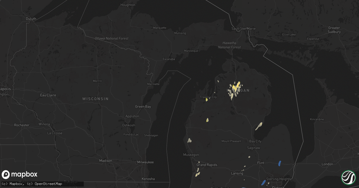
Hail Map in Michigan on June 25, 2023
Get this storm
June 25 map
$229
one time, instant access
Download today. No call, no setup
Keep the $229
Bought the map and want the full workflow? Apply the entire $229 to a subscription within 7 days. None of it is wasted.
Every map, not just this one
This buys you this map. Subscription and you get every map we run, in the markets you choose from a few cities to whole states to nationwide. Plus real-time alerts the moment a storm fires.
Contact data
Name, contact info, occupancy, even credit band for addresses in the footprint. You go from where it hit to who to call.
Become the source they trust
Unlimited branding weather history reports on demand. You already have the documented answer ready for the property owner, and you are the one who showed up with it.
Property data and RoofTrace estimates
Pull up any address you have got, its value and the exact code rules for that jurisdiction, straight from One Click Code. Then RoofTrace estimates the squares, pitch, and roof value, priced the way you price.
Storm reports in Michigan
Michigan
| Date | Description |
|---|---|
| 06/25/20236:20 PM CDT | Tree down blocking road. Time estimated by radar. |
| 06/25/20236:14 PM CDT | Numerous wires down across multiple roadways. Time estimated by radar. |
| 06/25/20236:09 PM CDT | Numerous wires down. Time estimated by radar. |
| 06/25/20236:09 PM CDT | Numerous trees and wires down. Additional trees and wires down reported throughout the county. |
| 06/25/20236:08 PM CDT | Tree down on road at intersection of linwood ave and mahaffy ave. |
| 06/25/20235:55 PM CDT | 14 inch diameter tree downed near 10 mile and mound rd. |
| 06/25/20235:51 PM CDT | Trees down near clintonville rd. Time estimated by radar. |
| 06/25/20235:48 PM CDT | Report of a tree down on a power line at north bard road and eaton road. Em stated that the power line was arcing. Time estimated by radar. |
| 06/25/20235:47 PM CDT | Large tree down on road... Along with many tree limbs reported down. |
| 06/25/20235:45 PM CDT | Trees down. Time estimated by radar. |
| 06/25/20235:45 PM CDT | Large tree down on car at detroit golf club |
| 06/25/20235:43 PM CDT | Numerous trees down. |
| 06/25/20235:35 PM CDT | Trees down at intersection of van born and beech daly roads. Time estimated by radar. |
| 06/25/20235:35 PM CDT | Trees down at intersection of van born and beech daly roads. Time estimated by radar. |
| 06/25/20235:35 PM CDT | Trees down. Time estimated by radar. |
| 06/25/20235:33 PM CDT | Several small limbs downed in south redford from photos on social media. Time estimated via radar. |
| 06/25/20235:27 PM CDT | Measured at kyip willow run airport. |
| 06/25/20235:27 PM CDT | Measured at detroit metropolitan airport. |
| 06/25/20235:22 PM CDT | Nollar road completely blocked due to large downed tree between 6 mile road and 7 mile road. Tree diameter approximately 24 inches. Time estimated by radar. |
| 06/25/20235:22 PM CDT | Trees down along 6 mile road near us 23. Time estimated by radar. |
| 06/25/20235:11 PM CDT | Trees down. |
| 06/25/20235:05 PM CDT | Wires down at intersection of lewis ave and sterns rd. |
| 06/25/20235:04 PM CDT | Trees down at intersection of douglas rd and smith rd. |
| 06/25/20235:02 PM CDT | 8 inch large tree limb down along ann arbor/saline road. |
| 06/25/20234:58 PM CDT | 911 call center reports multiple trees and wires down across the county. |
| 06/25/20234:50 PM CDT | Report of tree down. Estimated 60-70 mph gusts. Time estimated via radar. |
| 06/25/20234:45 PM CDT | Report of 1 inch hail near sparr. Time estimated by radar. |
| 06/25/20234:40 PM CDT | 911 call center reports multiple instances of trees and wires down across northern and eastern montcalm county. Time estimated via radar. |
| 06/25/20234:30 PM CDT | 911 call center reports multiple areas of trees and wires down across osceola and mecosta counties. Time estimated via radar. |
| 06/25/20234:30 PM CDT | 911 call center reports multiple tree limbs and wires down. |
| 06/25/20234:25 PM CDT | Delayed report relayed by broadcast media. Pontoon boat flipped over on far south end of lake leelanau. Time estimated. |
| 06/25/20234:25 PM CDT | Delayed report... Broadcast media reports tree blown over on golf course. Time estimated via radar. |
| 06/25/20234:24 PM CDT | Report of power lines down on hartman road. |
| 06/25/20234:18 PM CDT | Grand traverse county central dispatch reports a tree downed on a house near fire station 12 at silver lake. |
| 06/25/20234:16 PM CDT | 911 call center reports tree limbs down. |
| 06/25/20234:15 PM CDT | Jackson airport asos measures 61 mph gust. |
| 06/25/20234:14 PM CDT | Numerous large tree limbs down. |
| 06/25/20234:10 PM CDT | Trained spotter reports quarter sized hail and vehicle damage 1 mile north of chums corner in grand traverse county. Time estimated by radar. |
| 06/25/20234:00 PM CDT | Multiple large branches down. Relayed via social media. |
| 06/25/20234:00 PM CDT | 911 call center reports tree wrapped in power line. And multiple other wire and tree down calls. Time estimated via radar. |
| 06/25/20233:59 PM CDT | Numerous reports of tree limbs downed around au gres. Time estimated by radar. |
| 06/25/20233:55 PM CDT | 911 call center reports tree limbs and wires down. |
| 06/25/20233:55 PM CDT | Spotter reports 8 tree limbs down over roadway. |
| 06/25/20233:50 PM CDT | Report of 1.50 inch hail just west of gaylord. |
| 06/25/20233:40 PM CDT | Tree fallen onto car. Shared via social media. Time estimated via radar. |
| 06/25/20233:40 PM CDT | 911 call center reports tree limbs and wires down. Time estimated via radar. |
| 06/25/20233:40 PM CDT | Measured 1 inch hail by nws employee in gaylord at 4:40pm. |
| 06/25/20233:39 PM CDT | 911 call center reports multiple tree limbs and wires down across the county. |
| 06/25/20233:36 PM CDT | Tree blown down along with several smaller trees and limbs. Time estimated via radar. |
| 06/25/20233:35 PM CDT | 911 call center notes multiple areas of wires and trees down across the county. |
| 06/25/20233:30 PM CDT | Apple tree section >1 foot diameter snapped. |
| 06/25/20233:20 PM CDT | Cherry tree blown over. |
| 06/25/20233:20 PM CDT | Delayed report... Images relayed by media of multiple larger tree limbs down. Time estimated via radar. |
| 06/25/20233:10 PM CDT | A local report indicates 1.00 inch wind near 3 NNE Otsego Lake State |
| 06/25/20232:35 PM CDT | Trees down on old state rd. |
| 06/25/20232:30 PM CDT | Delayed report of a tree down at a residence in michaywe. |
| 06/25/20232:15 PM CDT | Trees and powerlines down on fir rd and redfield rd. |
| 06/25/20232:13 PM CDT | At 3:13pm... Reports of trees downed... With a report of a tree on a house northeast of ellsworth. Time estimated by radar. |
| 06/25/20232:10 PM CDT | Powerlines snapped in niles... Mi on fir road between redfield road and us-12. Time estimated from radar. |
| 06/25/20231:55 PM CDT | Utility pole snapped in half. |
| 06/25/20231:45 PM CDT | Broadcast media reports tree down on dayton road in buchanan... Mi. Time estimated by radar. |
| 06/25/20231:38 PM CDT | Trained spotter reports small branches 1 to 3 inches in diameter brought down by gusty winds. |
| 06/24/20237:11 PM CDT | Trees down. Downed wires also reported throughout st. Clair county. |
All States Impacted by Hail Map on June 25, 2023
Cities Impacted by Hail Map on June 25, 2023
- Hawley, TX
- Merkel, TX
- Abilene, TX
- Gordonsville, TN
- Lebanon, TN
- Carthage, TN
- Hickman, TN
- Brush Creek, TN
- Alexandria, TN
- Clarkson, KY
- Cub Run, KY
- Munfordville, KY
- Rineyville, KY
- Cecilia, KY
- Chicago, IL
- Portland, TN
- Bethpage, TN
- Crossville, TN
- Mammoth Cave, KY
- Whitesville, KY
- Fordsville, KY
- Omro, WI
- Glasgow, KY
- Eighty Eight, KY
- Leitchfield, KY
- Hardinsburg, KY
- Caneyville, KY
- McDaniels, KY
- Falls Of Rough, KY
- Horse Cave, KY
- Harned, KY
- Hudson, KY
- Greensburg, KY
- Summersville, KY
- Scottsville, KY
- Lucas, KY
- Cave City, KY
- Smiths Grove, KY
- Oakland, KY
- Bowling Green, KY
- Gamaliel, KY
- Fountain Run, KY
- Holland, KY
- Lafayette, TN
- Canmer, KY
- Magnolia, KY
- Hardyville, KY
- Center, KY
- Edmonton, KY
- Tompkinsville, KY
- Hartsville, TN
- Lawrenceburg, TN
- Westmoreland, TN
- Brownsville, KY
- Summer Shade, KY
- Hawesville, KY
- Monterey, TN
- Westview, KY
- Bonnieville, KY
- Sonora, KY
- Upton, KY
- Hodgenville, KY
- Collinwood, TN
- Hilham, TN
- Livingston, TN
- Tell City, IN
- Park City, KY
- Mount Hermon, KY
- Etoile, KY
- Austin, KY
- Eastview, KY
- Glendale, KY
- Big Clifty, KY
- Elizabethtown, KY
- Celina, TN
- Rocky Hill, KY
- Hobart, IN
- Valparaiso, IN
- White House, TN
- Cottontown, TN
- Cross Plains, TN
- Gallatin, TN
- Rickman, TN
- Clarkrange, TN
- Crawford, TN
- Cookeville, TN
- Castalian Springs, TN
- Red Boiling Springs, TN
- Watertown, TN
- Athens, AL
- Harvest, AL
- Toney, AL
- Madison, AL
- Kouts, IN
- La Crosse, IN
- Wanatah, IN
- Hanna, IN
- Hamlet, IN
- Grandview, TN
- Spring City, TN
- Pikeville, TN
- Ten Mile, TN
- Decatur, TN
- Clarks Hill, IN
- Linden, IN
- Darlington, IN
- Colfax, IN
- Frankfort, IN
- Tanner, AL
- Thorntown, IN
- Lebanon, IN
- Kirklin, IN
- Knox, IN
- Grovertown, IN
- Culver, IN
- Argos, IN
- Plymouth, IN
- Bourbon, IN
- Rochester, IN
- Kewanna, IN
- Tippecanoe, IN
- Royal Center, IN
- Logansport, IN
- Burnettsville, IN
- Idaville, IN
- Lucerne, IN
- Mentone, IN
- Bremen, IN
- Nappanee, IN
- Milford, IN
- New Paris, IN
- Etna Green, IN
- Clayton, IN
- Coatesville, IN
- Danville, IN
- Amo, IN
- Fillmore, IN
- Stilesville, IN
- Mooresville, IN
- Plainfield, IN
- Bowling Green, IN
- Poland, IN
- Spencer, IN
- Brazil, IN
- Reelsville, IN
- Centerpoint, IN
- Clay City, IN
- Coal City, IN
- Patricksburg, IN
- Sheridan, IN
- Atlanta, IN
- Kempton, IN
- Tipton, IN
- Gosport, IN
- Syracuse, IN
- Millersburg, IN
- Ligonier, IN
- Cromwell, IN
- Wawaka, IN
- Kimmell, IN
- Albion, IN
- Warsaw, IN
- Akron, IN
- Silver Lake, IN
- Claypool, IN
- Saint Paul, AR
- Pettigrew, AR
- Deer, AR
- Mount Judea, AR
- Witts Springs, AR
- Marshall, AR
- Carbon Hill, AL
- Townley, AL
- Jasper, AL
- Nauvoo, AL
- Bremen, AL
- Huntsville, AL
- Decatur, AL
- Hartselle, AL
- Somerville, AL
- Churubusco, IN
- Hudson, IN
- Rome City, IN
- Ashley, IN
- Laotto, IN
- Topeka, IN
- Corunna, IN
- South Milford, IN
- Avilla, IN
- Wolcottville, IN
- Kendallville, IN
- Waterloo, IN
- Garrett, IN
- Pleasant Lake, IN
- Arcadia, IN
- Cicero, IN
- Noblesville, IN
- Anderson, IN
- Frankton, IN
- Elwood, IN
- Ellettsville, IN
- Stinesville, IN
- Bloomington, IN
- Martinsville, IN
- Leslie, AR
- Unionville, IN
- Nashville, IN
- Ozone, AR
- Hanceville, AL
- Odon, IN
- Rossville, GA
- Chattanooga, TN
- Indianapolis, IN
- Camby, IN
- Greenwood, IN
- Whiteland, IN
- Bedford, IN
- Heltonville, IN
- Loogootee, IN
- Shoals, IN
- French Lick, IN
- Boggstown, IN
- Needham, IN
- Shelbyville, IN
- Fairland, IN
- Franklin, IN
- Fountaintown, IN
- Morristown, IN
- Huntertown, IN
- Spencerville, IN
- Fort Wayne, IN
- Saint Joe, IN
- Grabill, IN
- Leo, IN
- Auburn, IN
- Butler, IN
- Hamilton, IN
- Harlan, IN
- Hicksville, OH
- Edgerton, OH
- Pioneer, OH
- Montpelier, OH
- Osseo, MI
- Bryan, OH
- Mark Center, OH
- Camden, MI
- Edon, OH
- Angola, IN
- Hillsdale, MI
- Montgomery, MI
- Fremont, IN
- Columbia City, IN
- Larwill, IN
- Timbo, AR
- Fox, AR
- Onia, AR
- Arcola, IN
- Hagarville, AR
- North Manchester, IN
- Liberty Mills, IN
- South Whitley, IN
- Huntington, IN
- Gaylord, MI
- Owensville, IN
- Fort Branch, IN
- Princeton, IN
- Cannelburg, IN
- Montgomery, IN
- Washington, IN
- Francisco, IN
- Oakland City, IN
- Winslow, IN
- West Baden Springs, IN
- Paoli, IN
- Orleans, IN
- Sturgis, KY
- Morganfield, KY
- Ozark, IL
- Herod, IL
- Eddyville, IL
- Stonefort, IL
- Goreville, IL
- Cave In Rock, IL
- Elizabethtown, IL
- Newberry, IN
- Bloomfield, IN
- Scotland, IN
- Crane, IN
- Traverse City, MI
- Grawn, MI
- Williams, IN
- Owensburg, IN
- Springville, IN
- Luther, MI
- Oolitic, IN
- Hardinsburg, IN
- Mountain View, AR
- Homer, IN
- Rushville, IN
- Manilla, IN
- Arlington, IN
- Melbourne, AR
- Fifty Six, AR
- Daleville, IN
- Yorktown, IN
- Alexandria, IN
- Pelsor, AR
- Dover, AR
- Hector, AR
- Russellville, AR
- West Unity, OH
- Sherwood, OH
- Defiance, OH
- Ney, OH
- Waldron, MI
- Archbold, OH
- Fayette, OH
- Morenci, MI
- Hudson, MI
- Alvordton, OH
- Stryker, OH
- Pittsford, MI
- Payne, OH
- Monroeville, IN
- Woodburn, IN
- New Haven, IN
- Antwerp, OH
- Cecil, OH
- Paulding, OH
- Haviland, OH
- Clinton, AR
- Bee Branch, AR
- Choctaw, AR
- Fort Oglethorpe, GA
- Seymour, IN
- Velpen, IN
- Stendal, IN
- Huntingburg, IN
- Holland, IN
- Ferdinand, IN
- Jasper, IN
- Marengo, IN
- Depauw, IN
- Milltown, IN
- Sebree, KY
- Robards, KY
- Calhoun, KY
- Clay, KY
- Dixon, KY
- Providence, KY
- Nebo, KY
- Johannesburg, MI
- New Salisbury, IN
- Ramsey, IN
- Palmyra, IN
- Fredericksburg, IN
- North Vernon, IN
- Latty, OH
- Allen, MI
- Litchfield, MI
- Oakwood, OH
- Evansport, OH
- Napoleon, OH
- Sand Creek, MI
- Wauseon, OH
- Lyons, OH
- Adrian, MI
- Clayton, MI
- Jonesville, MI
- Blissfield, MI
- Jasper, MI
- Palmyra, MI
- Britton, MI
- Delta, OH
- Homer, MI
- Concord, MI
- Hanover, MI
- Horton, MI
- Jackson, MI
- Parma, MI
- Spring Arbor, MI
- Michigan Center, MI
- Grass Lake, MI
- Munith, MI
- Vanderbilt, MI
- Corydon, IN
- Crandall, IN
- Georgetown, IN
- Greenville, IN
- Campbellsburg, IN
- Commiskey, IN
- Paris Crossing, IN
- North Judson, IN
- Owensboro, KY
- Utica, KY
- Rumsey, KY
- Manitou, KY
- Slaughters, KY
- Hanson, KY
- Madisonville, KY
- Salem, IN
- Atkins, AR
- Hattieville, AR
- Morrilton, AR
- Pottsville, AR
- Deputy, IN
- Waleska, GA
- Rydal, GA
- Canton, GA
- White, GA
- Cartersville, GA
- Woodstock, GA
- Acworth, GA
- Kennesaw, GA
- Marietta, GA
- Peachtree Corners, GA
- Smyrna, GA
- Austell, GA
- Norcross, GA
- Alpharetta, GA
- Atlanta, GA
- Roswell, GA
- Guion, AR
- Pleasant Grove, AR
- Mount Pleasant, AR
- Batesville, AR
- Marcella, AR
- Sulphur Rock, AR
- Poughkeepsie, AR
- Sidney, AR
- Cave City, AR
- Dardanelle, AR
- Adona, AR
- Perry, AR
- Lanesville, IN
- Pekin, IN
- Saint Anthony, IN
- Birdseye, IN
- Schnellville, IN
- Tucker, GA
- Scottdale, GA
- Clarkston, GA
- Stone Mountain, GA
- Decatur, GA
- Avondale Estates, GA
- New Albany, IN
- Louisville, KY
- Plumerville, AR
- Houston, AR
- South Lyon, MI
- Elizabeth, IN
- Northville, MI
- New Hudson, MI
- Novi, MI
- Wixom, MI
- Milford, MI
- Walled Lake, MI
- Solgohachia, AR
- Damascus, AR
- Cleveland, AR
- Springfield, AR
- Center Ridge, AR
- Bargersville, IN
- El Paso, AR
- Enola, AR
- Vilonia, AR
- Wooster, AR
- Greenbrier, AR
- Conway, AR
- Mount Vernon, AR
- Jacksonville, AR
- Little Rock Air Force Base, AR
- Austin, AR
- Cabot, AR
- Sherwood, AR
- Maumelle, AR
- North Little Rock, AR
- Mayflower, AR
- Bigelow, AR
- Mableton, GA
- Madison, IN
- Dupont, IN
- Ellenwood, GA
- Conley, GA
- Cord, AR
- Talladega, AL
- Munford, AL
- Saffell, AR
- Lynn, AR
- Alicia, AR
- Smithville, AR
- Strawberry, AR
- Belleville, MI
- Romulus, MI
- Wayne, MI
- New Boston, MI
- Taylor, MI
- Detroit, MI
- Westland, MI
- Dearborn Heights, MI
- Allen Park, MI
- Inkster, MI
- Dearborn, MI
- Little Rock, AR
- Scott, AR
- Taylorsville, KY
- Fairdale, KY
- Lonoke, AR
- Redfield, AR
- Hensley, AR
- England, AR
- Keo, AR
- Carlisle, AR
- Shepherdsville, KY
- Jonesboro, AR
- Newark, AR
- Tuckerman, AR
- Cash, AR
- Swifton, AR
- Charlotte, AR
- Newport, AR
- Bono, AR
- Walnut Ridge, AR
- Bay, AR
- Trumann, AR
- Harrisburg, AR
- State University, AR
- Weiner, AR
- Sunman, IN
- Guilford, IN
- Lawrenceburg, IN
- Mount Washington, KY
- Cleves, OH
- West Harrison, IN
- Harrison, OH
- Batesville, IN
- Brookville, IN
- Milan, IN
- Cedar Grove, IN
- Hazen, AR
- Altheimer, AR
- Wabbaseka, AR
- Humnoke, AR
- Tucker, AR
- Coxs Creek, KY
- Bardstown, KY
- Spencer, TN
- Fayetteville, AR
- Elkins, AR
- Muncie, IN
- Rockville, IN
- Elmwood, TN
- Grayling, MI
- Oark, AR
- Clarksville, AR
- Frederic, MI
- Mcminnville, TN
- Beersheba Springs, TN
- Altamont, TN
- Lynnville, TN
- Ringgold, GA
- Combs, AR
- Meridianville, AL
- Chesterton, IN
- Romney, IN
- Westfield, IN
- Waynetown, IN
- Wingate, IN
- Hillsboro, IN
- Crawfordsville, IN
- New Richmond, IN
- Evanston, IN
- Lamar, IN
- Santa Claus, IN
- Baileyton, AL
- Eva, AL
- Joppa, AL
- Leoma, TN
- Pulaski, TN
- Goodspring, TN
- Signal Mountain, TN
- Ellijay, GA
- Chatsworth, GA
- Ranger, GA
- Pennsauken, NJ
- Philadelphia, PA
- Lyons, IN
- Hartford, KY
- Haubstadt, IN
- Ozark, AR
- Lamar, AR
- Witter, AR
- Holland, MI
- Fennville, MI
- Hamilton, MI
- Zeeland, MI
- Coatesville, PA
- Downingtown, PA
- Cannelton, IN
- Lewisport, KY
- Taswell, IN
- Rising Fawn, GA
- Lookout Mountain, GA
- Westphalia, IN
- Sandborn, IN
- Dennard, AR
- Manchester, TN
- Quitman, AR
- Thermopolis, WY
- Harriet, AR
- Big Flat, AR
- Gruetli Laager, TN
- Charlevoix, MI
- Ellsworth, MI
- Morrison, TN
- Hillsboro, TN
- Fayette, AL
- Berry, AL
- Eldridge, AL
- Bankston, AL
- Pleasant Shade, TN
- Boaz, AL
- Terre Haute, IN
- Cory, IN
- Lancaster, TN
- Boonville, IN
- Woodbury, TN
- Hart, MI
- Shelby, MI
- New Era, MI
- Eckerty, IN
- Holly Pond, AL
- Arab, AL
- Blountsville, AL
- Estillfork, AL
- Elberfeld, IN
- Spurgeon, IN
- Lynnville, IN
- Ooltewah, TN
- Cullman, AL
- Russellville, IN
- Ladoga, IN
- Waveland, IN
- Roachdale, IN
- Kingston, AR
- Brownsburg, IN
- Pittsboro, IN
- Winchester, TN
- Estill Springs, TN
- Tallapoosa, GA
- Muscadine, AL
- Waco, GA
- Chickamauga, GA
- Rock Spring, GA
- La Fayette, GA
- Trion, GA
- Linton, IN
- Runnemede, NJ
- Audubon, NJ
- Oaklyn, NJ
- Haddon Heights, NJ
- Haddonfield, NJ
- Collingswood, NJ
- Barrington, NJ
- Mount Ephraim, NJ
- Bellmawr, NJ
- Cynthiana, IN
- English, IN
- Roann, IN
- South Pittsburg, TN
- Sewanee, TN
- Elnora, IN
- Shawneetown, IL
- Junction, IL
- Ridgway, IL
- Ohatchee, AL
- Shelbyville, TN
- Lookout Mountain, TN
- Flintstone, GA
- Minor Hill, TN
- Tennyson, IN
- Chrisney, IN
- Riley, IN
- Mitchell, IN
- Twelve Mile, IN
- Dixon Springs, TN
- Riddleton, TN
- Cornersville, TN
- Granger, IN
- Niles, MI
- Granville, TN
- Buffalo Valley, TN
- Chestnut Mound, TN
- Au Gres, MI
- Monterey, IN
- San Pierre, IN
- Wheatfield, IN
- Leesburg, IN
- Liberty, TN
- Burket, IN
- Gibbsboro, NJ
- Voorhees, NJ
- Clementon, NJ
- Somerdale, NJ
- Magnolia, NJ
- Stratford, NJ
- Blackwood, NJ
- Woodbury, NJ
- Glendora, NJ
- Elkmont, AL
- Equality, IL
- Harrisburg, IL
- Eldorado, IL
- Ora, IN
- Walkerton, IN
- Laceys Spring, AL
- Chandler, IN
- Evansville, IN
- Gentryville, IN
- Richland, IN
- Newburgh, IN
- Ardmore, TN
- Loretto, TN
- Five Points, TN
- Falkville, AL
- Calhoun, GA
- Gainesboro, TN
- Bloomington Springs, TN
- Odenville, AL
- Pell City, AL
- Havre De Grace, MD
- Medora, IN
- Vinemont, AL
- Ardmore, AL
- Perryville, AR
- Lewisburg, TN
- Columbia, TN
- Belvidere, TN
- Bradyville, TN
- Fruithurst, AL
- Corydon, KY
- Waverly, KY
- Henderson, KY
- Uniontown, KY
- Macy, IN
- Sedan, KS
- Kalkaska, MI
- Guntersville, AL
- Union Grove, AL
- Allendale, MI
- Coopersville, MI
- Omaha, IL
- Armuchee, GA
- Summerville, GA
- Sugar Valley, GA
- Auburntown, TN
- Sharpsville, IN
- Continental, OH
- Dayton, TN
- Whitwell, TN
- Tracy City, TN
- Rocky Face, GA
- Toccoa, GA
- Valhermoso Springs, AL
- Trinity, AL
- Poseyville, IN
- Albertville, AL
- Crossville, AL
- North Liberty, IN
- Guild, TN
- Smithville, TN
- Waldron, IN
- Huntsville, AR
- Ponca, AR
- Steele, AL
- Gallant, AL
- Attalla, AL
- Beechgrove, TN
- Pierceton, IN
- Immokalee, FL
- Whiteside, TN
- Greencastle, IN
- Evensville, TN
- Rapid City, MI
- Aberdeen, MD
- Darlington, MD
- Churchville, MD
- Wheatland, IN
- Philpot, KY
- Hixson, TN
- Taft, TN
- Fayetteville, TN
- Hazel Green, AL
- Bruceville, IN
- Vincennes, IN
- Plainville, IN
- Monroe City, IN
- Dubois, IN
- Bicknell, IN
- Brownstown, IN
- Norman, IN
- Freetown, IN
- Laketon, IN
- Winona Lake, IN
- North Webster, IN
- Bristow, IN
- Dowelltown, TN
- Silver Point, TN
- New Middletown, IN
- Iron City, TN
- Saint Joseph, TN
- Lester, AL
- Westpoint, TN
- Prospect, TN
- Standish, MI
- Omer, MI
- Germansville, PA
- Slatington, PA
- West Newton, IN
- Solsberry, IN
- Westville, IN
- Marked Tree, AR
- Lake City, AR
- Caraway, AR
- Lepanto, AR
- Dyess, AR
- Wilson, AR
- Joiner, AR
- Frenchmans Bayou, AR
- Turrell, AR
- Gilmore, AR
- Bassett, AR
- Tyronza, AR
- Okeana, OH
- Hamilton, OH
- Oxford, OH
- Bloomfield, KY
- Allenton, MI
- Almont, MI
- Capac, MI
- Imlay City, MI
- De Witt, AR
- Humphrey, AR
- Ulm, AR
- Gillett, AR
- Almyra, AR
- Stuttgart, AR
- Clarendon, AR
- Crocketts Bluff, AR
- Holly Grove, AR
- Casscoe, AR
- Roe, AR
- De Valls Bluff, AR
- Fremont, OH
- Vickery, OH
- Clyde, OH
- Port Clinton, OH
- Oak Harbor, OH
- Lacarne, OH
- Lindsey, OH
- Elmore, OH
- Woodville, OH
- Gibsonburg, OH
- Helena, OH
- Burgoon, OH
- Green Springs, OH
- Castalia, OH
- Sandusky, OH
- Huron, OH
- Bellevue, OH
- Lakeside Marblehead, OH
- Kelleys Island, OH
- Memphis, TN
- Drummonds, TN
- Munford, TN
- Atoka, TN
- Marion, AR
- Crawfordsville, AR
- Arlington, TN
- Millington, TN
- Goshen, KY
- Prospect, KY
- Charlestown, IN
- Jeffersonville, IN
- Cropwell, AL
- Vincent, AL
- Childersburg, AL
- Alpine, AL
- Sylacauga, AL
- Goodwater, AL
- Crestwood, KY
- Pewee Valley, KY
- La Grange, KY
- Buckner, KY
- Smithfield, KY
- Simpsonville, KY
- Fisherville, KY
- Cordova, TN
- Eads, TN
- Ethel, AR
- Saint Charles, AR
- Tichnor, AR
- Snow Lake, AR
- Mellwood, AR
- Elaine, AR
- Lexa, AR
- Shelby, MS
- Marvell, AR
- Crumrod, AR
- Clarksdale, MS
- Duncan, MS
- Alligator, MS
- Gunnison, MS
- Helena, AR
- Poplar Grove, AR
- Clarksville, IN
- Troy, IN
- Saint Meinrad, IN
- Leavenworth, IN
- Leopold, IN
- Branchville, IN
- Battletown, KY
- Mauckport, IN
- Central, IN
- Glenview, KY
- Masonic Home, KY
- Shelbyville, KY
- Frankfort, KY
- Waddy, KY
- Lawrenceburg, KY
- Bagdad, KY
- Tutwiler, MS
- Sumner, MS
- Drew, MS
- Mound Bayou, MS
- Merigold, MS
- Parchman, MS
- Ruleville, MS
- Cleveland, MS
- Charleston, MS
- Union Star, KY
- Stephensport, KY
- Rome, IN
- Webster, KY
- Rockport, IN
- Grandview, IN
- Maceo, KY
- Derby, IN
- Spottsville, KY
- Reed, KY
- Irvington, KY
- Schlater, MS
- Minter City, MS
- Doddsville, MS
- Glendora, MS
- Cascilla, MS
- Greenwood, MS
- Philipp, MS
- Holcomb, MS
- Michigan City, MS
- Ashland, MS
- Falkner, MS
- Walnut, MS
- Moscow, TN
- Lamar, MS
- Grand Junction, TN
- Tiplersville, MS
- Blue Mountain, MS
- New Albany, MS
- Ripley, MS
- Holly Springs, MS
- Hickory Flat, MS
- Dumas, MS
- Booneville, MS
- Guntown, MS
- Baldwyn, MS
- Rienzi, MS
- Saltillo, MS
- Blue Springs, MS
- Water Valley, MS
- Oxford, MS
- Paris, MS
- Versailles, KY
- Guston, KY
- Payneville, KY
- Mantachie, MS
- Tupelo, MS
- New Site, MS
- Belmont, MS
- Fulton, MS
- Tishomingo, MS
- Marietta, MS
- Dennis, MS
- Banner, MS
- Randolph, MS
- Pontotoc, MS
- Itta Bena, MS
- Sidon, MS
- Carrollton, MS
- Clinton, KY
- Houlka, MS
- Bruce, MS
- Golden, MS
- Mooreville, MS
- Nettleton, MS
- Tremont, MS
- Coila, MS
- Vine Grove, KY
- Lexington, KY
- Nicholasville, KY
- Wingo, KY
- Mayfield, KY
- Sedalia, KY
- Richmond, KY
- West, MS
- Lexington, MS
- Durant, MS
- Ethel, MS
- Vaiden, MS
- Winona, MS
- North Carrollton, MS
- McCarley, MS
- Smithville, MS
- Salvisa, KY
- Harrodsburg, KY
- Lancaster, KY
- Wilmore, KY
- Burgin, KY
- Berea, KY
- Paint Lick, KY
- Waco, KY
- Olaton, KY
- Horse Branch, KY
- Dundee, KY
- Cruger, MS
- Louise, MS
- Isola, MS
- Tchula, MS
- Silver City, MS
- Inverness, MS
- Hollandale, MS
- Greenville, MS
- Anguilla, MS
- Leland, MS
- Indianola, MS
- Belzoni, MS
- Moorhead, MS
- Shaw, MS
- Sunflower, MS
- Benoit, MS
- Rohwer, AR
- Eudora, AR
- Dermott, AR
- Arkansas City, AR
- McGehee, AR
- Lake Village, AR
- Yazoo City, MS
- Holly Bluff, MS
- Glen Allan, MS
- Rolling Fork, MS
- Irvine, KY
- McKee, KY
- Sweeden, KY
- Bee Spring, KY
- Hot Springs Village, AR
- Hot Springs National Park, AR
- Mountain Pine, AR
- Mayersville, MS
- Satartia, MS
- Chatham, MS
- Benton, MS
- Tinsley, MS
- Bolton, MS
- Bentonia, MS
- Pickens, MS
- Goodman, MS
- Sallis, MS
- Vaughan, MS
- Knob Lick, KY
- Campbellsville, KY
- Vincent, KY
- Booneville, KY
- Beattyville, KY
- Jackson, MS
- Madison, MS
- Flora, MS
- Canton, MS
- Camden, MS
- Carthage, MS
- Kosciusko, MS
- Malvern, AR
- Lena, MS
- Ridgeland, MS
- Brandon, MS
- Tougaloo, MS
- Clinton, MS
- Ricetown, KY
- Breeding, KY
- Gradyville, KY
- Columbia, KY
- Glens Fork, KY
- Knifley, KY
- Russell Springs, KY
- Warren, AR
- Wilmar, AR
- Jamestown, KY
- Flowood, MS
- Pearl, MS
- Richland, MS
- Florence, MS
- Braxton, MS
- Pelahatchie, MS
- Morton, MS
- Forest, MS
- Mendenhall, MS
- Pinola, MS
- Monticello, AR
- Donaldson, AR
- Pearcy, AR
- Bonnerdale, AR
- Coal Hill, AR
- Altus, AR
- Scranton, AR
- Hartman, AR
- Lexington, IN
- Scottsburg, IN
- Bowling Green, OH
- Rison, AR
- Lewiston, CA
- Cedartown, GA
- Van Wert, OH
- Willshire, OH
- Ohio City, OH
- Wren, OH
- Convoy, OH
- Tuskegee, AL
- Notasulga, AL
- Tallassee, AL
- Cadillac, MI
- Robertsdale, AL
- Lockport, KY
- Bethlehem, KY
- Owenton, KY
- Campbellsburg, KY
- Dansville, MI
- Eastaboga, AL
- Benton, KY
- Kirksey, KY
- Sheridan, AR
- Latham, NY
- Watervliet, NY
- Albany, NY
- Wellington, AL
- Aurora, IN
- Austin, IN
- Crothersville, IN
- Bedford, KY
- Bethlehem, IN
- Pendleton, KY
- Nabb, IN
- Hanover, IN
- Portsmouth, VA
- Chesapeake, VA
- Watson, AR
- Cragford, AL
- Alexander City, AL
- Ashland, AL
- Daviston, AL
- Milton, KY
- Carrollton, KY
- Hartford City, IN
- Mancelona, MI
- Elmira, MI
- Berlin, NJ
- Sicklerville, NJ
- Millwood, KY
- Reynolds Station, KY
- Vincentown, NJ
- West Berlin, NJ
- Atco, NJ
- Danville, AR
- Belleville, AR
- Morgantown, KY
- Stamping Ground, KY
- Pinson, AL
- Trussville, AL
- Plymouth, MI
- Holgate, OH
- Ottawa, OH
- Hamler, OH
- Miller City, OH
- Deshler, OH
- New Bavaria, OH
- Leipsic, OH
- Jetson, KY
- Roundhill, KY
- Laingsburg, MI
- Brandenburg, KY
- Chesaning, MI
- Oakley, MI
- Saint Croix, IN
- Rhodelia, KY
- Lonsdale, AR
- Water Valley, KY
- Fulton, KY
- Lineville, AL
- Mabelvale, AR
- Buchanan, GA
- Villa Rica, GA
- Tillar, AR
- Hoxie, AR
- New Castle, KY
- Pleasureville, KY
- Delaware, AR
- Rockmart, GA
- Bremen, GA
- Temple, GA
- Dallas, GA
- Douglasville, GA
- Winston, GA
- Memphis, IN
- Borden, IN
- Henryville, IN
- Lebanon, KY
- Danville, AL
- Wedowee, AL
- Woodland, AL
- Kingsland, AR
- Bismarck, AR
- Norfolk, VA
- Virginia Beach, VA
- Casa, AR
- Knoxville, AR
- Ola, AR
- London, AR
- Altoona, AL
- Alexander, AR
- White Hall, AR
- Bryant, AR
- Bauxite, AR
- New Liberty, KY
- Worthville, KY
- Sanders, KY
- Centre, AL
- Piedmont, AL
- Paron, AR
- Plainview, AR
- Chaplin, KY
- Brooks, KY
- Monroe, IN
- Berne, IN
- Columbus, IN
- Owosso, MI
- Fort Knox, KY
- New Edinburg, AR
- Chatsworth, NJ
- Browns Mills, NJ
- Decatur, IN
- Bowdon, GA
- Shorter, AL
- Danville, KY
- Hermitage, AR
- Hamburg, AR
- Rover, AR
- Montague, CA
- Fairburn, GA
- Palmetto, GA
- Alexandria, AL
- Kellyton, AL
- Rockford, AL
- Bound Brook, NJ
- Middlesex, NJ
- Martinsville, NJ
- Dunellen, NJ
- Warren, NJ
- Lincoln, AL
- Heflin, AL
- Harpersville, AL
- Weed, CA
- Ekron, KY
- Custer, KY
- Radcliff, KY
- Beebe, AR
- Ragland, AL
- Anniston, AL
- Riverside, AL
- Equality, AL
- Oxford, AL
- Farmington, MI
- Auburn, AL
- Jessieville, AR
- Willisburg, KY
- Finchville, KY
- Briggsville, AR
- Sulphur, IN
- Star City, AR
- Haslett, MI
- East Lansing, MI
- Harrisville, MS
- Raleigh, MS
- Louin, MS
- Magee, MS
- Pulaski, MS
- Lake, MS
- Fairfield, KY
- Turners Station, KY
- Buffalo, KY
- Pemberville, OH
- Jacksonville, AL
- New Blaine, AR
- Grapevine, AR
- Stanford, KY
- Vallonia, IN
- Pine Bluff, AR
- Boyle, MS
- Murray, KY
- Farmington, KY
- Hazel, KY
- Laconia, IN
- Westport, KY
- Sulphur, KY
- Sellersburg, IN
- Mount Eden, KY
- Underwood, IN
- Floyds Knobs, IN
- Springfield, KY
- Mackville, KY
- Otisco, IN
- Grantsburg, IN
- Monticello, KY
- Nancy, KY
- Alpha, KY
- Bronston, KY
- Leola, AR
- Mize, MS
- Taylorsville, MS
- Prentiss, MS
- Newhebron, MS
- Mount Olive, MS
- Stringer, MS
- Bay Springs, MS
- Collins, MS
- Laurel, MS
- Soso, MS
- Sumrall, MS
- Seminary, MS
- Bassfield, MS
- Ellisville, MS
- Moselle, MS
- Carson, MS
- Arkadelphia, AR
- Stearns, KY
- Whitley City, KY
- Burnside, KY
- Corbin, KY
- Rockholds, KY
- Williamsburg, KY
- Barbourville, KY
- Woodbine, KY
- Siler, KY
- Pineville, KY
- Frakes, KY
- Bryants Store, KY
- Calvin, KY
- Trosper, KY
- Amity, AR
- Harrell, AR
- Hampton, AR
- Ovett, MS
- Richton, MS
- Petal, MS
- Beaumont, MS
- New Augusta, MS
- State Line, MS
- Waynesboro, MS
- Middlesboro, KY
- New Tazewell, TN
- Speedwell, TN
- Cumberland Gap, TN
- Ewing, VA
- Harrogate, TN
- Tazewell, TN
- Thorn Hill, TN
- Rutledge, TN
- Washburn, TN
- Bean Station, TN
- Kirby, AR
- Delight, AR
- Dandridge, TN
- Morristown, TN
- Jefferson City, TN
- Talbott, TN
- White Pine, TN
- Newport, TN
- Cosby, TN
- Parrottsville, TN
- Bybee, TN
- Del Rio, TN
- Neely, MS
- McLain, MS
- Leakesville, MS
- Wilmer, AL
- Lucedale, MS
- Citronelle, AL
- Chunchula, AL
- Vinegar Bend, AL
- Hartford, TN
- Valliant, OK
- Ringold, OK
- Hooks, TX
- Texarkana, TX
- Ashdown, AR
- Livonia, MI
- Broken Bow, OK
- Casper, WY
- Glenns Ferry, ID
- Eutaw, AL
- Parkdale, AR
- Auburn, KY
- Portland, AR
- Lewisburg, KY
- Greenville, KY
- Belton, KY
- Norman, AR
- Aberdeen, MS
- Prairie, MS
- Amory, MS
- Hamilton, MS
- Dexter, KY
- Hardin, KY
- Almo, KY
- Franklin, KY
- Nashville, AR
- Ozan, AR
- Murfreesboro, AR
- Alvaton, KY
- Rochester, KY
- Oneonta, AL
- Troy, AL
- Perryville, KY
- Thomasville, AL
- Centertown, KY
- Central City, KY
- Bremen, KY
- Highland Home, AL
- Grady, AL
- Luverne, AL
- Wilmot, AR
- Jones, LA
- Adolphus, KY
- Winfield, AL
- Mount Holly, AR
- Smackover, AR
- Rattan, OK
- Okolona, AR
- Antoine, AR
- Burkesville, KY
- Chidester, AR
- Gurdon, AR
- Prescott, AR
- Dawson Springs, KY
- Elba, AL
- Goshen, AL
- Glenwood, AL
- Lake Providence, LA
- Sweet Water, AL
- Rensselaer, NY
- Troy, NY
- Springville, AL
- Banks, AR
- Ramer, AL
- Camden, AR
- Mount Ida, AR
- Royal, AR
- Friendship, AR
- Sulligent, AL
- Byram, MS
- Buckatunna, MS
- Springfield, TN
- Umpire, AR
- Mena, AR
- Union Springs, AL
- Fitzpatrick, AL
- Pemberton, NJ
- Kinston, AL
- Edgemont, SD
- Bluff City, AR
- Woodburn, KY
- Counce, TN
- Savannah, TN
- Story, AR
- Greenville, AL
- Beaumont, KY
- Eupora, MS
- Walthall, MS
- New Madrid, MO
- Crossett, AR
- Fountain Hill, AR
- Stephens, AR
- Columbus, MS
- Garvin, OK
- Raywick, KY
- Fordyce, AR
- Poyen, AR
- Bearden, AR
- Sparkman, AR
- Carthage, AR
- Thornton, AR
- Montrose, AR
- Eagletown, OK
- Horton, AL
- Earlington, KY
- Princeton, KY
- Kennedy, AL
- Hattiesburg, MS
- East Prairie, MO
- Wright City, OK
- Fort Towson, OK
- El Dorado, AR
- Oakman, AL
- Starkville, MS
- Caddo Gap, AR
- Langley, AR
- Shubuta, MS
- Blevins, AR
- McCaskill, AR
- Newhope, AR
- Glenwood, AR
- Burna, KY
- Nashoba, OK
- Hatfield, AR
- Beaverton, AL
- Beaver Dam, KY
- Henderson, TN
- Finger, TN
- Gilbertown, AL
- Melvin, AL
- Russellville, KY
- Vicksburg, MS
- White Plains, KY
- Nortonville, KY
- Idabel, OK
- Brantley, AL
- Samson, AL
- Cromwell, KY
- Rockport, KY
- McHenry, KY
- Marion, KY
- Fredonia, KY
- Greenwood Springs, MS
- Mathiston, MS
- West Point, KY
- Sacramento, KY
- Drakesboro, KY
- Tuskegee Institute, AL
- Salem, KY
- Prattsville, AR
- Burnsville, MS
- Sandgap, KY
- Haworth, OK
- Nash, TX
- Rosston, AR
- McNeil, AR
- Cohoes, NY
- Yorktown, AR
- Wetumpka, AL
- Coffeeville, MS
- Quitman, MS
- Clayton, OK
- Crab Orchard, KY
- Fouke, AR
- Texarkana, AR
- Queen City, TX
- Doddridge, AR
- Bloomburg, TX
- Ida, LA
- Gilliam, LA
- Plain Dealing, LA
- Bradley, AR
- Benton, LA
- Cotton Valley, LA
- Sarepta, LA
- Minden, LA
- Lance Creek, WY
- Shreveport, LA
- Marion, LA
- Emmet, AR
- Lewisville, AR
- Homer, LA
- Athens, LA
- Vancleave, MS
- Lusk, WY
- Jackson, AL
- Saint Stephens, AL
- Maud, TX
- Junction City, AR
- Hope, AR
- Bastrop, LA
- Haynesville, LA
- Arcadia, LA
- Shongaloo, LA
- Gibsland, LA
- Oak Grove, LA
- Gulf Breeze, FL
- Jersey, AR
- Waldo, AR
- Willisville, AR
- Buckner, AR
- Milroy, IN
- Magnolia, AR
- Harrison, NE
- New Boston, TX
- Dierks, AR
- Lockesburg, AR
- Mineral Springs, AR
- Simsboro, LA
- Huttig, AR
- Monroeville, AL
- Peterman, AL
- Fulton, AR
- Emerson, AR
- Lafayette, IN
- Lexington, TN
- Reagan, TN
- De Queen, AR
- Foreman, AR
- Pennington, AL
- Navarre, FL
- Pine Hill, AL
- Lower Peach Tree, AL
- Eglin Afb, FL
- Linden, AL
- Mooringsport, LA
- Saratoga, AR
- Gainestown, AL
- Horatio, AR
- Whatley, AL
- Franklin, AL
- Repton, AL
- Coden, AL
- Needham, AL
- Butler, AL
- Silas, AL
- Bonita, LA
- Sardis, AL
- Evergreen, AL
- Tallulah, LA
- De Kalb, TX
- Jacks Creek, TN
- Enville, TN


