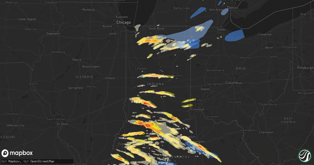
Hail Map in Indiana on June 25, 2023
Get this storm
June 25 map
$229
one time, instant access
Download today. No call, no setup
Keep the $229
Bought the map and want the full workflow? Apply the entire $229 to a subscription within 7 days. None of it is wasted.
Every map, not just this one
This buys you this map. Subscription and you get every map we run, in the markets you choose from a few cities to whole states to nationwide. Plus real-time alerts the moment a storm fires.
Contact data
Name, contact info, occupancy, even credit band for addresses in the footprint. You go from where it hit to who to call.
Become the source they trust
Unlimited branding weather history reports on demand. You already have the documented answer ready for the property owner, and you are the one who showed up with it.
Property data and RoofTrace estimates
Pull up any address you have got, its value and the exact code rules for that jurisdiction, straight from One Click Code. Then RoofTrace estimates the squares, pitch, and roof value, priced the way you price.
Storm reports in Indiana
Indiana
| Date | Description |
|---|---|
| 06/25/20236:45 PM CDT | A local report indicates 1.00 inch wind near 3 NW Syria |
| 06/25/20236:11 PM CDT | Mping report |
| 06/25/20236:11 PM CDT | A local report indicates 1.00 inch wind near 4 SW Bright |
| 06/25/20236:04 PM CDT | Mping report. |
| 06/25/20235:36 PM CDT | A local report indicates 1.25 inch wind near 1 SE Georgetown |
| 06/25/20235:26 PM CDT | A local report indicates 1.00 inch wind near 2 W North Madison |
| 06/25/20235:25 PM CDT | A local report indicates 1.75 inch wind near Madison |
| 06/25/20235:23 PM CDT | A local report indicates 1.50 inch wind near 1 NW North Madison |
| 06/25/20235:20 PM CDT | Picture of uprooted tree relayed on social media. |
| 06/25/20235:18 PM CDT | Tree down on i-64 near exit 122. |
| 06/25/20235:15 PM CDT | Time estimated significant wind damage. |
| 06/25/20235:15 PM CDT | Time estimated - significant wind damage. |
| 06/25/20234:58 PM CDT | A local report indicates 1.00 inch wind near 1 W Georgetown |
| 06/25/20234:49 PM CDT | A local report indicates 2.00 inch wind near 1 NW Ramsey |
| 06/25/20234:45 PM CDT | Relayed report of possible damage in jennings county along cr 640 west near commiskey. Barn roof blown off and trees uprooted. Time estimated from radar. |
| 06/25/20234:41 PM CDT | Dubois county highway garage. |
| 06/25/20234:39 PM CDT | Report from mping: quarter |
| 06/25/20234:37 PM CDT | Report of quarter |
| 06/25/20234:35 PM CDT | A local report indicates 1.00 inch wind near 3 NW Syria |
| 06/25/20234:30 PM CDT | 2 trees down over clay street in huntingburg. |
| 06/25/20234:29 PM CDT | Quarter sized hail fell. |
| 06/25/20234:29 PM CDT | 2.5 inch hail fell at a storm spotter home. |
| 06/25/20234:25 PM CDT | Public report of tree damage and barn doors blown in and off. |
| 06/25/20234:24 PM CDT | A local report indicates 2.75 inch wind near French Lick |
| 06/25/20234:22 PM CDT | A local report indicates 1.50 inch wind near Marengo |
| 06/25/20234:20 PM CDT | Late report relayed via facebook. 1 foot diameter persimmon tree fell onto a detached garage on south side of chandler. |
| 06/25/20234:20 PM CDT | A local report indicates 1.50 inch wind near 7 SE Winslow |
| 06/25/20234:19 PM CDT | A local report indicates 1.25 inch wind near 7 SE Winslow |
| 06/25/20234:15 PM CDT | Reported by trained spotter. Dime to quarter sized hail for about 5 minutes. |
| 06/25/20234:12 PM CDT | 3 to 6 inch tree limb down on sherman blvd. Time estimated from radar. |
| 06/25/20234:11 PM CDT | Report from mping: 1-inch tree limbs broken; shingles blown off. |
| 06/25/20234:05 PM CDT | Report from mping: quarter |
| 06/25/20234:05 PM CDT | Report relayed via facebook. |
| 06/25/20234:03 PM CDT | Delayed report. |
| 06/25/20234:01 PM CDT | 18 inch tree down on hatzel road in new haven... In. |
| 06/25/20234:01 PM CDT | Report of 3 inch tree limbs down at the intersection of newnum rd and st. Joe rd. Time estimated from radar. |
| 06/25/20234:00 PM CDT | Corrects event type for tstm wnd gst report from 2 s coesse. Mesonet station pdu05 northeast purdue agricultural center. |
| 06/25/20233:59 PM CDT | . |
| 06/25/20233:59 PM CDT | A local report indicates 1.00 inch wind near North Manchester |
| 06/25/20233:56 PM CDT | A local report indicates 3.00 inch wind near West Baden Springs |
| 06/25/20233:56 PM CDT | Picture relayed from social media. |
| 06/25/20233:55 PM CDT | At the french lick resort. |
| 06/25/20233:55 PM CDT | Time estimated from radar. |
| 06/25/20233:52 PM CDT | Hail ranged from quarters to golf ball sized. Driving by the toyota plant south of princeton indiana. |
| 06/25/20233:50 PM CDT | A local report indicates 1.25 inch wind near Daleville |
| 06/25/20233:44 PM CDT | Kenny park. 18 inch diameter tree snapped... Appears healthy. Several limbs downed. |
| 06/25/20233:38 PM CDT | A local report indicates 70 MPH wind near 3 WNW Hamilton Lake |
| 06/25/20233:35 PM CDT | 10 inch diameter tree branches down in angola. |
| 06/25/20233:35 PM CDT | Reports of multiple trees down on homes and cars. No reports of injuries at this time. |
| 06/25/20233:34 PM CDT | Delayed report. Some shingles taken off roof at residence and flag pole snapped off 2 feet above the ground. |
| 06/25/20233:33 PM CDT | Multiple pictures from the public of a possible tornado near highway 31 and worthsville road. |
| 06/25/20233:33 PM CDT | Confirmed tornado... Debris visible rotating on the ground. |
| 06/25/20233:31 PM CDT | Report from mping: quarter |
| 06/25/20233:30 PM CDT | Corrects previous hail report from north manchester. Corrected time of occurrence. |
| 06/25/20233:30 PM CDT | Damage at a car dealership at 1006 south wayne street in angola... In. Damage to vehicles and structures. Reported by angola fd... Relayed by emergency manager. Time es |
| 06/25/20233:30 PM CDT | Powerlines down in northeast hamilton... In. Time estimated from radar. |
| 06/25/20233:30 PM CDT | Tornado possible. |
| 06/25/20233:27 PM CDT | Delayed public report of hail in between quarter and golf ball size in loogootee via social media. Time estimated via radar. |
| 06/25/20233:27 PM CDT | A local report indicates 1.50 inch wind near 2 NNE Southport |
| 06/25/20233:25 PM CDT | 3 inch measured hailstone. Delayed report. |
| 06/25/20233:25 PM CDT | Ema volunteer reports structural damage to a large barn and a small outbuilding destroyed by strong winds. Time estimated from radar. |
| 06/25/20233:25 PM CDT | Emergency manager reports damage to a barn. Part of barn roof in the roadway at cr 950 e and cr 100 n. Time estimated from radar. |
| 06/25/20233:25 PM CDT | Salem township fire department has wind damage to their building including a portion of the roof missing and damage to a wall. Reported by steuben county emergency mana |
| 06/25/20233:23 PM CDT | A local report indicates 1.00 inch wind near Columbia City |
| 06/25/20233:22 PM CDT | Report from mping: half dollar |
| 06/25/20233:20 PM CDT | Multiple videos sent in on social media of a tornado on the ground near stones crossing road and state road 135. Time estimated via radar. |
| 06/25/20233:20 PM CDT | Time estimated from radar. |
| 06/25/20233:18 PM CDT | Report from mping: half dollar |
| 06/25/20233:18 PM CDT | Corrects source for previous hail report from north manchester. Photos on twitter show estimated quarter size hail in north manchester... In. Time estimated by radar. |
| 06/25/20233:18 PM CDT | Photos on twitter show estimated quarter size hail in north manchester... In. Time estimated by radar. |
| 06/25/20233:16 PM CDT | A local report indicates 1.00 inch wind near 3 S Paragon |
| 06/25/20233:16 PM CDT | Report from mping: golf ball |
| 06/25/20233:16 PM CDT | A local report indicates 1.00 inch wind near 1 SSE Bloomington |
| 06/25/20233:15 PM CDT | Delayed report via social media. Damage reported to homes in the waters edge subdivision. Time estimated via radar. *tor possible*. |
| 06/25/20233:15 PM CDT | Photos of trees down and roof damage to homes in neighborhood south of center grove hs near intersection of morgantown and travis rds. Time estimated via radar. *tor po |
| 06/25/20233:15 PM CDT | Multiple public reports of damage to structures and heavily damaged roofs off stones crossing road in the kensington grove neighborhood. Time estimated via radar. *tor |
| 06/25/20233:15 PM CDT | A local report indicates 2.50 inch wind near 2 S Ellettsville |
| 06/25/20233:15 PM CDT | A local report indicates 2.00 inch wind near 1 E Ellettsville |
| 06/25/20233:14 PM CDT | Report from mping: quarter |
| 06/25/20233:12 PM CDT | A local report indicates 1.00 inch wind near 3 N Disko |
| 06/25/20233:10 PM CDT | Multiple delayed reports via social media of measured 1.75 inch hail in ellettsville. Time estimated via radar. |
| 06/25/20233:10 PM CDT | Multiple videos on social media of a tornado on the ground at the intersection of i-69 and sr-144. |
| 06/25/20233:08 PM CDT | Report from mping: quarter |
| 06/25/20233:06 PM CDT | Delayed report. |
| 06/25/20233:06 PM CDT | Pictures of tree damage just off i-69 at the loogootee exit. Delayed report... Time estimated via radar. |
| 06/25/20233:05 PM CDT | Report from mping: quarter |
| 06/25/20233:05 PM CDT | A local report indicates 2.75 inch wind near Spencer |
| 06/25/20233:03 PM CDT | Powerlines down in larwill. Time estimated by radar. |
| 06/25/20233:00 PM CDT | Emergency manager reports tree down onto vehicle in larwill. No known injuries. Time estimated from radar. |
| 06/25/20233:00 PM CDT | Multiple trees with snapped limbs 6 to 12 inches in diameter in rome city. Photos from twitter. Time estimated from radar. |
| 06/25/20233:00 PM CDT | Public report of tree damage... Blocking speedway drive. Time estimated via radar. |
| 06/25/20232:59 PM CDT | Report from mping: half dollar |
| 06/25/20232:57 PM CDT | Several 1 ft diameter tree limbs downed. Appear healthy from photos. |
| 06/25/20232:56 PM CDT | The hail lasted about 5 min. |
| 06/25/20232:55 PM CDT | Report from mping: tennis ball |
| 06/25/20232:54 PM CDT | Report from mping: half dollar |
| 06/25/20232:53 PM CDT | Report from mping: quarter |
| 06/25/20232:47 PM CDT | Report from mping: 1-inch tree limbs broken; shingles blown off. |
| 06/25/20232:47 PM CDT | Quarter sized hail reported by member of public in n plainfield. Time estimated via radar. |
| 06/25/20232:45 PM CDT | Report from mping: tennis ball |
| 06/25/20232:45 PM CDT | Public report on facebook of quarter size hail in mentone... In. Time estimated by radar. |
| 06/25/20232:45 PM CDT | Public report of 2 inch hail in kirklin... In via social media. |
| 06/25/20232:40 PM CDT | Trained spotter reports tree snapped in half on their property. Multiple large branches across pinkerton and price roads. |
| 06/25/20232:37 PM CDT | A local report indicates 1.50 inch wind near Clayton |
| 06/25/20232:36 PM CDT | Broadcast media reports tree and powerlines down at the intersection of w main street and n dolan drive in syracuse... In. Time estimated by radar. |
| 06/25/20232:30 PM CDT | A local report indicates 1.00 inch wind near Akron |
| 06/25/20232:25 PM CDT | Picture of pool-ball sized hail submitted on social media by member of public. |
| 06/25/20232:25 PM CDT | Picture of ping-pong ball sized hail e of colfax. Time estimated to be 3:25 pm. |
| 06/25/20232:24 PM CDT | Large tree down... Powerlines down... And 1 to 3 inch tree limbs snapped near twin lakes... In. Near the intersection of 13th road and south rose road. Time estimated b |
| 06/25/20232:18 PM CDT | Damage to roof and siding of home. |
| 06/25/20232:18 PM CDT | Size estimated from references used in social media photos. |
| 06/25/20232:17 PM CDT | Report from mping: quarter |
| 06/25/20232:15 PM CDT | A local report indicates 62 MPH wind near 4 W Rochester |
| 06/25/20232:14 PM CDT | A local report indicates 1.00 inch wind near Argos |
| 06/25/20232:14 PM CDT | Report from mping: 1-inch tree limbs broken; shingles blown off. |
| 06/25/20232:14 PM CDT | . |
| 06/25/20232:13 PM CDT | Delayed report. |
| 06/25/20232:12 PM CDT | Public report on twitter of quarter size hail in bremen. Time estimated from radar. |
| 06/25/20232:11 PM CDT | Delayed report. |
| 06/25/20232:10 PM CDT | Report from mping: quarter |
| 06/25/20232:06 PM CDT | Photos on twitter of baseball size hailstones in plymouth. Time estimated from radar. |
| 06/25/20231:54 PM CDT | A local report indicates 1.00 inch wind near Royal Center |
| 06/25/20231:47 PM CDT | A local report indicates 1.75 inch wind near 2 E Knox |
| 06/25/20231:45 PM CDT | Trained spotter reports quarter size hail in knox... In. |
| 06/25/20231:42 PM CDT | Broadcast media report of golf ball size hail in knox... In. Time estimated from radar. |
| 06/25/20231:40 PM CDT | Multiple pictures on facebook of 2 inch hailstones and one 3 inch hailstone that fell in knox... In around 1:40 pm ct. |
| 06/25/20231:36 PM CDT | Time and location are estimated - numerous tree limbs down. |
| 06/25/20231:36 PM CDT | A local report indicates 1.00 inch wind near Toto |
| 06/25/20231:36 PM CDT | A local report indicates 1.50 inch wind near Knox |
| 06/25/20231:35 PM CDT | A local report indicates 1.75 inch wind near 1 E Knox |
| 06/25/20231:34 PM CDT | Reported by not trained spotter. |
| 06/25/20231:12 PM CDT | A local report indicates 1.50 inch wind near La Crosse |
| 06/25/20231:08 PM CDT | Public report on facebook of nickel to quarter size hail near la crosse... In. Time estimated from radar. |
| 06/25/20231:05 PM CDT | Trained spotter reports hail 1 to 1.5 inches in diameter in la crosse... In. |
| 06/24/20238:25 PM CDT | Report of nickel to quarter sized hail in town of hatfield. |
| 06/24/20238:06 PM CDT | A local report indicates 1.25 inch wind near 3 WSW New Middletown |
| 06/24/20237:52 PM CDT | Multiple reports of 1 to 1.25 inch sized hail from social media. |
| 06/24/20237:47 PM CDT | A local report indicates 1.50 inch wind near 1 E Fredonia |
| 06/24/20237:37 PM CDT | Delayed report. |
| 06/24/20237:34 PM CDT | Report from mping: 1-inch tree limbs broken; shingles blown off. |
| 06/24/20237:15 PM CDT | Firework tent damage and a tree fallen onto a power line near the white castle. |
| 06/24/20237:14 PM CDT | Quarter sized hail in vesta. |
All States Impacted by Hail Map on June 25, 2023
Cities Impacted by Hail Map on June 25, 2023
- Hawley, TX
- Merkel, TX
- Abilene, TX
- Gordonsville, TN
- Lebanon, TN
- Carthage, TN
- Hickman, TN
- Brush Creek, TN
- Alexandria, TN
- Clarkson, KY
- Cub Run, KY
- Munfordville, KY
- Rineyville, KY
- Cecilia, KY
- Chicago, IL
- Portland, TN
- Bethpage, TN
- Crossville, TN
- Mammoth Cave, KY
- Whitesville, KY
- Fordsville, KY
- Omro, WI
- Glasgow, KY
- Eighty Eight, KY
- Leitchfield, KY
- Hardinsburg, KY
- Caneyville, KY
- McDaniels, KY
- Falls Of Rough, KY
- Horse Cave, KY
- Harned, KY
- Hudson, KY
- Greensburg, KY
- Summersville, KY
- Scottsville, KY
- Lucas, KY
- Cave City, KY
- Smiths Grove, KY
- Oakland, KY
- Bowling Green, KY
- Gamaliel, KY
- Fountain Run, KY
- Holland, KY
- Lafayette, TN
- Canmer, KY
- Magnolia, KY
- Hardyville, KY
- Center, KY
- Edmonton, KY
- Tompkinsville, KY
- Hartsville, TN
- Lawrenceburg, TN
- Westmoreland, TN
- Brownsville, KY
- Summer Shade, KY
- Hawesville, KY
- Monterey, TN
- Westview, KY
- Bonnieville, KY
- Sonora, KY
- Upton, KY
- Hodgenville, KY
- Collinwood, TN
- Hilham, TN
- Livingston, TN
- Tell City, IN
- Park City, KY
- Mount Hermon, KY
- Etoile, KY
- Austin, KY
- Eastview, KY
- Glendale, KY
- Big Clifty, KY
- Elizabethtown, KY
- Celina, TN
- Rocky Hill, KY
- Hobart, IN
- Valparaiso, IN
- White House, TN
- Cottontown, TN
- Cross Plains, TN
- Gallatin, TN
- Rickman, TN
- Clarkrange, TN
- Crawford, TN
- Cookeville, TN
- Castalian Springs, TN
- Red Boiling Springs, TN
- Watertown, TN
- Athens, AL
- Harvest, AL
- Toney, AL
- Madison, AL
- Kouts, IN
- La Crosse, IN
- Wanatah, IN
- Hanna, IN
- Hamlet, IN
- Grandview, TN
- Spring City, TN
- Pikeville, TN
- Ten Mile, TN
- Decatur, TN
- Clarks Hill, IN
- Linden, IN
- Darlington, IN
- Colfax, IN
- Frankfort, IN
- Tanner, AL
- Thorntown, IN
- Lebanon, IN
- Kirklin, IN
- Knox, IN
- Grovertown, IN
- Culver, IN
- Argos, IN
- Plymouth, IN
- Bourbon, IN
- Rochester, IN
- Kewanna, IN
- Tippecanoe, IN
- Royal Center, IN
- Logansport, IN
- Burnettsville, IN
- Idaville, IN
- Lucerne, IN
- Mentone, IN
- Bremen, IN
- Nappanee, IN
- Milford, IN
- New Paris, IN
- Etna Green, IN
- Clayton, IN
- Coatesville, IN
- Danville, IN
- Amo, IN
- Fillmore, IN
- Stilesville, IN
- Mooresville, IN
- Plainfield, IN
- Bowling Green, IN
- Poland, IN
- Spencer, IN
- Brazil, IN
- Reelsville, IN
- Centerpoint, IN
- Clay City, IN
- Coal City, IN
- Patricksburg, IN
- Sheridan, IN
- Atlanta, IN
- Kempton, IN
- Tipton, IN
- Gosport, IN
- Syracuse, IN
- Millersburg, IN
- Ligonier, IN
- Cromwell, IN
- Wawaka, IN
- Kimmell, IN
- Albion, IN
- Warsaw, IN
- Akron, IN
- Silver Lake, IN
- Claypool, IN
- Saint Paul, AR
- Pettigrew, AR
- Deer, AR
- Mount Judea, AR
- Witts Springs, AR
- Marshall, AR
- Carbon Hill, AL
- Townley, AL
- Jasper, AL
- Nauvoo, AL
- Bremen, AL
- Huntsville, AL
- Decatur, AL
- Hartselle, AL
- Somerville, AL
- Churubusco, IN
- Hudson, IN
- Rome City, IN
- Ashley, IN
- Laotto, IN
- Topeka, IN
- Corunna, IN
- South Milford, IN
- Avilla, IN
- Wolcottville, IN
- Kendallville, IN
- Waterloo, IN
- Garrett, IN
- Pleasant Lake, IN
- Arcadia, IN
- Cicero, IN
- Noblesville, IN
- Anderson, IN
- Frankton, IN
- Elwood, IN
- Ellettsville, IN
- Stinesville, IN
- Bloomington, IN
- Martinsville, IN
- Leslie, AR
- Unionville, IN
- Nashville, IN
- Ozone, AR
- Hanceville, AL
- Odon, IN
- Rossville, GA
- Chattanooga, TN
- Indianapolis, IN
- Camby, IN
- Greenwood, IN
- Whiteland, IN
- Bedford, IN
- Heltonville, IN
- Loogootee, IN
- Shoals, IN
- French Lick, IN
- Boggstown, IN
- Needham, IN
- Shelbyville, IN
- Fairland, IN
- Franklin, IN
- Fountaintown, IN
- Morristown, IN
- Huntertown, IN
- Spencerville, IN
- Fort Wayne, IN
- Saint Joe, IN
- Grabill, IN
- Leo, IN
- Auburn, IN
- Butler, IN
- Hamilton, IN
- Harlan, IN
- Hicksville, OH
- Edgerton, OH
- Pioneer, OH
- Montpelier, OH
- Osseo, MI
- Bryan, OH
- Mark Center, OH
- Camden, MI
- Edon, OH
- Angola, IN
- Hillsdale, MI
- Montgomery, MI
- Fremont, IN
- Columbia City, IN
- Larwill, IN
- Timbo, AR
- Fox, AR
- Onia, AR
- Arcola, IN
- Hagarville, AR
- North Manchester, IN
- Liberty Mills, IN
- South Whitley, IN
- Huntington, IN
- Gaylord, MI
- Owensville, IN
- Fort Branch, IN
- Princeton, IN
- Cannelburg, IN
- Montgomery, IN
- Washington, IN
- Francisco, IN
- Oakland City, IN
- Winslow, IN
- West Baden Springs, IN
- Paoli, IN
- Orleans, IN
- Sturgis, KY
- Morganfield, KY
- Ozark, IL
- Herod, IL
- Eddyville, IL
- Stonefort, IL
- Goreville, IL
- Cave In Rock, IL
- Elizabethtown, IL
- Newberry, IN
- Bloomfield, IN
- Scotland, IN
- Crane, IN
- Traverse City, MI
- Grawn, MI
- Williams, IN
- Owensburg, IN
- Springville, IN
- Luther, MI
- Oolitic, IN
- Hardinsburg, IN
- Mountain View, AR
- Homer, IN
- Rushville, IN
- Manilla, IN
- Arlington, IN
- Melbourne, AR
- Fifty Six, AR
- Daleville, IN
- Yorktown, IN
- Alexandria, IN
- Pelsor, AR
- Dover, AR
- Hector, AR
- Russellville, AR
- West Unity, OH
- Sherwood, OH
- Defiance, OH
- Ney, OH
- Waldron, MI
- Archbold, OH
- Fayette, OH
- Morenci, MI
- Hudson, MI
- Alvordton, OH
- Stryker, OH
- Pittsford, MI
- Payne, OH
- Monroeville, IN
- Woodburn, IN
- New Haven, IN
- Antwerp, OH
- Cecil, OH
- Paulding, OH
- Haviland, OH
- Clinton, AR
- Bee Branch, AR
- Choctaw, AR
- Fort Oglethorpe, GA
- Seymour, IN
- Velpen, IN
- Stendal, IN
- Huntingburg, IN
- Holland, IN
- Ferdinand, IN
- Jasper, IN
- Marengo, IN
- Depauw, IN
- Milltown, IN
- Sebree, KY
- Robards, KY
- Calhoun, KY
- Clay, KY
- Dixon, KY
- Providence, KY
- Nebo, KY
- Johannesburg, MI
- New Salisbury, IN
- Ramsey, IN
- Palmyra, IN
- Fredericksburg, IN
- North Vernon, IN
- Latty, OH
- Allen, MI
- Litchfield, MI
- Oakwood, OH
- Evansport, OH
- Napoleon, OH
- Sand Creek, MI
- Wauseon, OH
- Lyons, OH
- Adrian, MI
- Clayton, MI
- Jonesville, MI
- Blissfield, MI
- Jasper, MI
- Palmyra, MI
- Britton, MI
- Delta, OH
- Homer, MI
- Concord, MI
- Hanover, MI
- Horton, MI
- Jackson, MI
- Parma, MI
- Spring Arbor, MI
- Michigan Center, MI
- Grass Lake, MI
- Munith, MI
- Vanderbilt, MI
- Corydon, IN
- Crandall, IN
- Georgetown, IN
- Greenville, IN
- Campbellsburg, IN
- Commiskey, IN
- Paris Crossing, IN
- North Judson, IN
- Owensboro, KY
- Utica, KY
- Rumsey, KY
- Manitou, KY
- Slaughters, KY
- Hanson, KY
- Madisonville, KY
- Salem, IN
- Atkins, AR
- Hattieville, AR
- Morrilton, AR
- Pottsville, AR
- Deputy, IN
- Waleska, GA
- Rydal, GA
- Canton, GA
- White, GA
- Cartersville, GA
- Woodstock, GA
- Acworth, GA
- Kennesaw, GA
- Marietta, GA
- Peachtree Corners, GA
- Smyrna, GA
- Austell, GA
- Norcross, GA
- Alpharetta, GA
- Atlanta, GA
- Roswell, GA
- Guion, AR
- Pleasant Grove, AR
- Mount Pleasant, AR
- Batesville, AR
- Marcella, AR
- Sulphur Rock, AR
- Poughkeepsie, AR
- Sidney, AR
- Cave City, AR
- Dardanelle, AR
- Adona, AR
- Perry, AR
- Lanesville, IN
- Pekin, IN
- Saint Anthony, IN
- Birdseye, IN
- Schnellville, IN
- Tucker, GA
- Scottdale, GA
- Clarkston, GA
- Stone Mountain, GA
- Decatur, GA
- Avondale Estates, GA
- New Albany, IN
- Louisville, KY
- Plumerville, AR
- Houston, AR
- South Lyon, MI
- Elizabeth, IN
- Northville, MI
- New Hudson, MI
- Novi, MI
- Wixom, MI
- Milford, MI
- Walled Lake, MI
- Solgohachia, AR
- Damascus, AR
- Cleveland, AR
- Springfield, AR
- Center Ridge, AR
- Bargersville, IN
- El Paso, AR
- Enola, AR
- Vilonia, AR
- Wooster, AR
- Greenbrier, AR
- Conway, AR
- Mount Vernon, AR
- Jacksonville, AR
- Little Rock Air Force Base, AR
- Austin, AR
- Cabot, AR
- Sherwood, AR
- Maumelle, AR
- North Little Rock, AR
- Mayflower, AR
- Bigelow, AR
- Mableton, GA
- Madison, IN
- Dupont, IN
- Ellenwood, GA
- Conley, GA
- Cord, AR
- Talladega, AL
- Munford, AL
- Saffell, AR
- Lynn, AR
- Alicia, AR
- Smithville, AR
- Strawberry, AR
- Belleville, MI
- Romulus, MI
- Wayne, MI
- New Boston, MI
- Taylor, MI
- Detroit, MI
- Westland, MI
- Dearborn Heights, MI
- Allen Park, MI
- Inkster, MI
- Dearborn, MI
- Little Rock, AR
- Scott, AR
- Taylorsville, KY
- Fairdale, KY
- Lonoke, AR
- Redfield, AR
- Hensley, AR
- England, AR
- Keo, AR
- Carlisle, AR
- Shepherdsville, KY
- Jonesboro, AR
- Newark, AR
- Tuckerman, AR
- Cash, AR
- Swifton, AR
- Charlotte, AR
- Newport, AR
- Bono, AR
- Walnut Ridge, AR
- Bay, AR
- Trumann, AR
- Harrisburg, AR
- State University, AR
- Weiner, AR
- Sunman, IN
- Guilford, IN
- Lawrenceburg, IN
- Mount Washington, KY
- Cleves, OH
- West Harrison, IN
- Harrison, OH
- Batesville, IN
- Brookville, IN
- Milan, IN
- Cedar Grove, IN
- Hazen, AR
- Altheimer, AR
- Wabbaseka, AR
- Humnoke, AR
- Tucker, AR
- Coxs Creek, KY
- Bardstown, KY
- Spencer, TN
- Fayetteville, AR
- Elkins, AR
- Muncie, IN
- Rockville, IN
- Elmwood, TN
- Grayling, MI
- Oark, AR
- Clarksville, AR
- Frederic, MI
- Mcminnville, TN
- Beersheba Springs, TN
- Altamont, TN
- Lynnville, TN
- Ringgold, GA
- Combs, AR
- Meridianville, AL
- Chesterton, IN
- Romney, IN
- Westfield, IN
- Waynetown, IN
- Wingate, IN
- Hillsboro, IN
- Crawfordsville, IN
- New Richmond, IN
- Evanston, IN
- Lamar, IN
- Santa Claus, IN
- Baileyton, AL
- Eva, AL
- Joppa, AL
- Leoma, TN
- Pulaski, TN
- Goodspring, TN
- Signal Mountain, TN
- Ellijay, GA
- Chatsworth, GA
- Ranger, GA
- Pennsauken, NJ
- Philadelphia, PA
- Lyons, IN
- Hartford, KY
- Haubstadt, IN
- Ozark, AR
- Lamar, AR
- Witter, AR
- Holland, MI
- Fennville, MI
- Hamilton, MI
- Zeeland, MI
- Coatesville, PA
- Downingtown, PA
- Cannelton, IN
- Lewisport, KY
- Taswell, IN
- Rising Fawn, GA
- Lookout Mountain, GA
- Westphalia, IN
- Sandborn, IN
- Dennard, AR
- Manchester, TN
- Quitman, AR
- Thermopolis, WY
- Harriet, AR
- Big Flat, AR
- Gruetli Laager, TN
- Charlevoix, MI
- Ellsworth, MI
- Morrison, TN
- Hillsboro, TN
- Fayette, AL
- Berry, AL
- Eldridge, AL
- Bankston, AL
- Pleasant Shade, TN
- Boaz, AL
- Terre Haute, IN
- Cory, IN
- Lancaster, TN
- Boonville, IN
- Woodbury, TN
- Hart, MI
- Shelby, MI
- New Era, MI
- Eckerty, IN
- Holly Pond, AL
- Arab, AL
- Blountsville, AL
- Estillfork, AL
- Elberfeld, IN
- Spurgeon, IN
- Lynnville, IN
- Ooltewah, TN
- Cullman, AL
- Russellville, IN
- Ladoga, IN
- Waveland, IN
- Roachdale, IN
- Kingston, AR
- Brownsburg, IN
- Pittsboro, IN
- Winchester, TN
- Estill Springs, TN
- Tallapoosa, GA
- Muscadine, AL
- Waco, GA
- Chickamauga, GA
- Rock Spring, GA
- La Fayette, GA
- Trion, GA
- Linton, IN
- Runnemede, NJ
- Audubon, NJ
- Oaklyn, NJ
- Haddon Heights, NJ
- Haddonfield, NJ
- Collingswood, NJ
- Barrington, NJ
- Mount Ephraim, NJ
- Bellmawr, NJ
- Cynthiana, IN
- English, IN
- Roann, IN
- South Pittsburg, TN
- Sewanee, TN
- Elnora, IN
- Shawneetown, IL
- Junction, IL
- Ridgway, IL
- Ohatchee, AL
- Shelbyville, TN
- Lookout Mountain, TN
- Flintstone, GA
- Minor Hill, TN
- Tennyson, IN
- Chrisney, IN
- Riley, IN
- Mitchell, IN
- Twelve Mile, IN
- Dixon Springs, TN
- Riddleton, TN
- Cornersville, TN
- Granger, IN
- Niles, MI
- Granville, TN
- Buffalo Valley, TN
- Chestnut Mound, TN
- Au Gres, MI
- Monterey, IN
- San Pierre, IN
- Wheatfield, IN
- Leesburg, IN
- Liberty, TN
- Burket, IN
- Gibbsboro, NJ
- Voorhees, NJ
- Clementon, NJ
- Somerdale, NJ
- Magnolia, NJ
- Stratford, NJ
- Blackwood, NJ
- Woodbury, NJ
- Glendora, NJ
- Elkmont, AL
- Equality, IL
- Harrisburg, IL
- Eldorado, IL
- Ora, IN
- Walkerton, IN
- Laceys Spring, AL
- Chandler, IN
- Evansville, IN
- Gentryville, IN
- Richland, IN
- Newburgh, IN
- Ardmore, TN
- Loretto, TN
- Five Points, TN
- Falkville, AL
- Calhoun, GA
- Gainesboro, TN
- Bloomington Springs, TN
- Odenville, AL
- Pell City, AL
- Havre De Grace, MD
- Medora, IN
- Vinemont, AL
- Ardmore, AL
- Perryville, AR
- Lewisburg, TN
- Columbia, TN
- Belvidere, TN
- Bradyville, TN
- Fruithurst, AL
- Corydon, KY
- Waverly, KY
- Henderson, KY
- Uniontown, KY
- Macy, IN
- Sedan, KS
- Kalkaska, MI
- Guntersville, AL
- Union Grove, AL
- Allendale, MI
- Coopersville, MI
- Omaha, IL
- Armuchee, GA
- Summerville, GA
- Sugar Valley, GA
- Auburntown, TN
- Sharpsville, IN
- Continental, OH
- Dayton, TN
- Whitwell, TN
- Tracy City, TN
- Rocky Face, GA
- Toccoa, GA
- Valhermoso Springs, AL
- Trinity, AL
- Poseyville, IN
- Albertville, AL
- Crossville, AL
- North Liberty, IN
- Guild, TN
- Smithville, TN
- Waldron, IN
- Huntsville, AR
- Ponca, AR
- Steele, AL
- Gallant, AL
- Attalla, AL
- Beechgrove, TN
- Pierceton, IN
- Immokalee, FL
- Whiteside, TN
- Greencastle, IN
- Evensville, TN
- Rapid City, MI
- Aberdeen, MD
- Darlington, MD
- Churchville, MD
- Wheatland, IN
- Philpot, KY
- Hixson, TN
- Taft, TN
- Fayetteville, TN
- Hazel Green, AL
- Bruceville, IN
- Vincennes, IN
- Plainville, IN
- Monroe City, IN
- Dubois, IN
- Bicknell, IN
- Brownstown, IN
- Norman, IN
- Freetown, IN
- Laketon, IN
- Winona Lake, IN
- North Webster, IN
- Bristow, IN
- Dowelltown, TN
- Silver Point, TN
- New Middletown, IN
- Iron City, TN
- Saint Joseph, TN
- Lester, AL
- Westpoint, TN
- Prospect, TN
- Standish, MI
- Omer, MI
- Germansville, PA
- Slatington, PA
- West Newton, IN
- Solsberry, IN
- Westville, IN
- Marked Tree, AR
- Lake City, AR
- Caraway, AR
- Lepanto, AR
- Dyess, AR
- Wilson, AR
- Joiner, AR
- Frenchmans Bayou, AR
- Turrell, AR
- Gilmore, AR
- Bassett, AR
- Tyronza, AR
- Okeana, OH
- Hamilton, OH
- Oxford, OH
- Bloomfield, KY
- Allenton, MI
- Almont, MI
- Capac, MI
- Imlay City, MI
- De Witt, AR
- Humphrey, AR
- Ulm, AR
- Gillett, AR
- Almyra, AR
- Stuttgart, AR
- Clarendon, AR
- Crocketts Bluff, AR
- Holly Grove, AR
- Casscoe, AR
- Roe, AR
- De Valls Bluff, AR
- Fremont, OH
- Vickery, OH
- Clyde, OH
- Port Clinton, OH
- Oak Harbor, OH
- Lacarne, OH
- Lindsey, OH
- Elmore, OH
- Woodville, OH
- Gibsonburg, OH
- Helena, OH
- Burgoon, OH
- Green Springs, OH
- Castalia, OH
- Sandusky, OH
- Huron, OH
- Bellevue, OH
- Lakeside Marblehead, OH
- Kelleys Island, OH
- Memphis, TN
- Drummonds, TN
- Munford, TN
- Atoka, TN
- Marion, AR
- Crawfordsville, AR
- Arlington, TN
- Millington, TN
- Goshen, KY
- Prospect, KY
- Charlestown, IN
- Jeffersonville, IN
- Cropwell, AL
- Vincent, AL
- Childersburg, AL
- Alpine, AL
- Sylacauga, AL
- Goodwater, AL
- Crestwood, KY
- Pewee Valley, KY
- La Grange, KY
- Buckner, KY
- Smithfield, KY
- Simpsonville, KY
- Fisherville, KY
- Cordova, TN
- Eads, TN
- Ethel, AR
- Saint Charles, AR
- Tichnor, AR
- Snow Lake, AR
- Mellwood, AR
- Elaine, AR
- Lexa, AR
- Shelby, MS
- Marvell, AR
- Crumrod, AR
- Clarksdale, MS
- Duncan, MS
- Alligator, MS
- Gunnison, MS
- Helena, AR
- Poplar Grove, AR
- Clarksville, IN
- Troy, IN
- Saint Meinrad, IN
- Leavenworth, IN
- Leopold, IN
- Branchville, IN
- Battletown, KY
- Mauckport, IN
- Central, IN
- Glenview, KY
- Masonic Home, KY
- Shelbyville, KY
- Frankfort, KY
- Waddy, KY
- Lawrenceburg, KY
- Bagdad, KY
- Tutwiler, MS
- Sumner, MS
- Drew, MS
- Mound Bayou, MS
- Merigold, MS
- Parchman, MS
- Ruleville, MS
- Cleveland, MS
- Charleston, MS
- Union Star, KY
- Stephensport, KY
- Rome, IN
- Webster, KY
- Rockport, IN
- Grandview, IN
- Maceo, KY
- Derby, IN
- Spottsville, KY
- Reed, KY
- Irvington, KY
- Schlater, MS
- Minter City, MS
- Doddsville, MS
- Glendora, MS
- Cascilla, MS
- Greenwood, MS
- Philipp, MS
- Holcomb, MS
- Michigan City, MS
- Ashland, MS
- Falkner, MS
- Walnut, MS
- Moscow, TN
- Lamar, MS
- Grand Junction, TN
- Tiplersville, MS
- Blue Mountain, MS
- New Albany, MS
- Ripley, MS
- Holly Springs, MS
- Hickory Flat, MS
- Dumas, MS
- Booneville, MS
- Guntown, MS
- Baldwyn, MS
- Rienzi, MS
- Saltillo, MS
- Blue Springs, MS
- Water Valley, MS
- Oxford, MS
- Paris, MS
- Versailles, KY
- Guston, KY
- Payneville, KY
- Mantachie, MS
- Tupelo, MS
- New Site, MS
- Belmont, MS
- Fulton, MS
- Tishomingo, MS
- Marietta, MS
- Dennis, MS
- Banner, MS
- Randolph, MS
- Pontotoc, MS
- Itta Bena, MS
- Sidon, MS
- Carrollton, MS
- Clinton, KY
- Houlka, MS
- Bruce, MS
- Golden, MS
- Mooreville, MS
- Nettleton, MS
- Tremont, MS
- Coila, MS
- Vine Grove, KY
- Lexington, KY
- Nicholasville, KY
- Wingo, KY
- Mayfield, KY
- Sedalia, KY
- Richmond, KY
- West, MS
- Lexington, MS
- Durant, MS
- Ethel, MS
- Vaiden, MS
- Winona, MS
- North Carrollton, MS
- McCarley, MS
- Smithville, MS
- Salvisa, KY
- Harrodsburg, KY
- Lancaster, KY
- Wilmore, KY
- Burgin, KY
- Berea, KY
- Paint Lick, KY
- Waco, KY
- Olaton, KY
- Horse Branch, KY
- Dundee, KY
- Cruger, MS
- Louise, MS
- Isola, MS
- Tchula, MS
- Silver City, MS
- Inverness, MS
- Hollandale, MS
- Greenville, MS
- Anguilla, MS
- Leland, MS
- Indianola, MS
- Belzoni, MS
- Moorhead, MS
- Shaw, MS
- Sunflower, MS
- Benoit, MS
- Rohwer, AR
- Eudora, AR
- Dermott, AR
- Arkansas City, AR
- McGehee, AR
- Lake Village, AR
- Yazoo City, MS
- Holly Bluff, MS
- Glen Allan, MS
- Rolling Fork, MS
- Irvine, KY
- McKee, KY
- Sweeden, KY
- Bee Spring, KY
- Hot Springs Village, AR
- Hot Springs National Park, AR
- Mountain Pine, AR
- Mayersville, MS
- Satartia, MS
- Chatham, MS
- Benton, MS
- Tinsley, MS
- Bolton, MS
- Bentonia, MS
- Pickens, MS
- Goodman, MS
- Sallis, MS
- Vaughan, MS
- Knob Lick, KY
- Campbellsville, KY
- Vincent, KY
- Booneville, KY
- Beattyville, KY
- Jackson, MS
- Madison, MS
- Flora, MS
- Canton, MS
- Camden, MS
- Carthage, MS
- Kosciusko, MS
- Malvern, AR
- Lena, MS
- Ridgeland, MS
- Brandon, MS
- Tougaloo, MS
- Clinton, MS
- Ricetown, KY
- Breeding, KY
- Gradyville, KY
- Columbia, KY
- Glens Fork, KY
- Knifley, KY
- Russell Springs, KY
- Warren, AR
- Wilmar, AR
- Jamestown, KY
- Flowood, MS
- Pearl, MS
- Richland, MS
- Florence, MS
- Braxton, MS
- Pelahatchie, MS
- Morton, MS
- Forest, MS
- Mendenhall, MS
- Pinola, MS
- Monticello, AR
- Donaldson, AR
- Pearcy, AR
- Bonnerdale, AR
- Coal Hill, AR
- Altus, AR
- Scranton, AR
- Hartman, AR
- Lexington, IN
- Scottsburg, IN
- Bowling Green, OH
- Rison, AR
- Lewiston, CA
- Cedartown, GA
- Van Wert, OH
- Willshire, OH
- Ohio City, OH
- Wren, OH
- Convoy, OH
- Tuskegee, AL
- Notasulga, AL
- Tallassee, AL
- Cadillac, MI
- Robertsdale, AL
- Lockport, KY
- Bethlehem, KY
- Owenton, KY
- Campbellsburg, KY
- Dansville, MI
- Eastaboga, AL
- Benton, KY
- Kirksey, KY
- Sheridan, AR
- Latham, NY
- Watervliet, NY
- Albany, NY
- Wellington, AL
- Aurora, IN
- Austin, IN
- Crothersville, IN
- Bedford, KY
- Bethlehem, IN
- Pendleton, KY
- Nabb, IN
- Hanover, IN
- Portsmouth, VA
- Chesapeake, VA
- Watson, AR
- Cragford, AL
- Alexander City, AL
- Ashland, AL
- Daviston, AL
- Milton, KY
- Carrollton, KY
- Hartford City, IN
- Mancelona, MI
- Elmira, MI
- Berlin, NJ
- Sicklerville, NJ
- Millwood, KY
- Reynolds Station, KY
- Vincentown, NJ
- West Berlin, NJ
- Atco, NJ
- Danville, AR
- Belleville, AR
- Morgantown, KY
- Stamping Ground, KY
- Pinson, AL
- Trussville, AL
- Plymouth, MI
- Holgate, OH
- Ottawa, OH
- Hamler, OH
- Miller City, OH
- Deshler, OH
- New Bavaria, OH
- Leipsic, OH
- Jetson, KY
- Roundhill, KY
- Laingsburg, MI
- Brandenburg, KY
- Chesaning, MI
- Oakley, MI
- Saint Croix, IN
- Rhodelia, KY
- Lonsdale, AR
- Water Valley, KY
- Fulton, KY
- Lineville, AL
- Mabelvale, AR
- Buchanan, GA
- Villa Rica, GA
- Tillar, AR
- Hoxie, AR
- New Castle, KY
- Pleasureville, KY
- Delaware, AR
- Rockmart, GA
- Bremen, GA
- Temple, GA
- Dallas, GA
- Douglasville, GA
- Winston, GA
- Memphis, IN
- Borden, IN
- Henryville, IN
- Lebanon, KY
- Danville, AL
- Wedowee, AL
- Woodland, AL
- Kingsland, AR
- Bismarck, AR
- Norfolk, VA
- Virginia Beach, VA
- Casa, AR
- Knoxville, AR
- Ola, AR
- London, AR
- Altoona, AL
- Alexander, AR
- White Hall, AR
- Bryant, AR
- Bauxite, AR
- New Liberty, KY
- Worthville, KY
- Sanders, KY
- Centre, AL
- Piedmont, AL
- Paron, AR
- Plainview, AR
- Chaplin, KY
- Brooks, KY
- Monroe, IN
- Berne, IN
- Columbus, IN
- Owosso, MI
- Fort Knox, KY
- New Edinburg, AR
- Chatsworth, NJ
- Browns Mills, NJ
- Decatur, IN
- Bowdon, GA
- Shorter, AL
- Danville, KY
- Hermitage, AR
- Hamburg, AR
- Rover, AR
- Montague, CA
- Fairburn, GA
- Palmetto, GA
- Alexandria, AL
- Kellyton, AL
- Rockford, AL
- Bound Brook, NJ
- Middlesex, NJ
- Martinsville, NJ
- Dunellen, NJ
- Warren, NJ
- Lincoln, AL
- Heflin, AL
- Harpersville, AL
- Weed, CA
- Ekron, KY
- Custer, KY
- Radcliff, KY
- Beebe, AR
- Ragland, AL
- Anniston, AL
- Riverside, AL
- Equality, AL
- Oxford, AL
- Farmington, MI
- Auburn, AL
- Jessieville, AR
- Willisburg, KY
- Finchville, KY
- Briggsville, AR
- Sulphur, IN
- Star City, AR
- Haslett, MI
- East Lansing, MI
- Harrisville, MS
- Raleigh, MS
- Louin, MS
- Magee, MS
- Pulaski, MS
- Lake, MS
- Fairfield, KY
- Turners Station, KY
- Buffalo, KY
- Pemberville, OH
- Jacksonville, AL
- New Blaine, AR
- Grapevine, AR
- Stanford, KY
- Vallonia, IN
- Pine Bluff, AR
- Boyle, MS
- Murray, KY
- Farmington, KY
- Hazel, KY
- Laconia, IN
- Westport, KY
- Sulphur, KY
- Sellersburg, IN
- Mount Eden, KY
- Underwood, IN
- Floyds Knobs, IN
- Springfield, KY
- Mackville, KY
- Otisco, IN
- Grantsburg, IN
- Monticello, KY
- Nancy, KY
- Alpha, KY
- Bronston, KY
- Leola, AR
- Mize, MS
- Taylorsville, MS
- Prentiss, MS
- Newhebron, MS
- Mount Olive, MS
- Stringer, MS
- Bay Springs, MS
- Collins, MS
- Laurel, MS
- Soso, MS
- Sumrall, MS
- Seminary, MS
- Bassfield, MS
- Ellisville, MS
- Moselle, MS
- Carson, MS
- Arkadelphia, AR
- Stearns, KY
- Whitley City, KY
- Burnside, KY
- Corbin, KY
- Rockholds, KY
- Williamsburg, KY
- Barbourville, KY
- Woodbine, KY
- Siler, KY
- Pineville, KY
- Frakes, KY
- Bryants Store, KY
- Calvin, KY
- Trosper, KY
- Amity, AR
- Harrell, AR
- Hampton, AR
- Ovett, MS
- Richton, MS
- Petal, MS
- Beaumont, MS
- New Augusta, MS
- State Line, MS
- Waynesboro, MS
- Middlesboro, KY
- New Tazewell, TN
- Speedwell, TN
- Cumberland Gap, TN
- Ewing, VA
- Harrogate, TN
- Tazewell, TN
- Thorn Hill, TN
- Rutledge, TN
- Washburn, TN
- Bean Station, TN
- Kirby, AR
- Delight, AR
- Dandridge, TN
- Morristown, TN
- Jefferson City, TN
- Talbott, TN
- White Pine, TN
- Newport, TN
- Cosby, TN
- Parrottsville, TN
- Bybee, TN
- Del Rio, TN
- Neely, MS
- McLain, MS
- Leakesville, MS
- Wilmer, AL
- Lucedale, MS
- Citronelle, AL
- Chunchula, AL
- Vinegar Bend, AL
- Hartford, TN
- Valliant, OK
- Ringold, OK
- Hooks, TX
- Texarkana, TX
- Ashdown, AR
- Livonia, MI
- Broken Bow, OK
- Casper, WY
- Glenns Ferry, ID
- Eutaw, AL
- Parkdale, AR
- Auburn, KY
- Portland, AR
- Lewisburg, KY
- Greenville, KY
- Belton, KY
- Norman, AR
- Aberdeen, MS
- Prairie, MS
- Amory, MS
- Hamilton, MS
- Dexter, KY
- Hardin, KY
- Almo, KY
- Franklin, KY
- Nashville, AR
- Ozan, AR
- Murfreesboro, AR
- Alvaton, KY
- Rochester, KY
- Oneonta, AL
- Troy, AL
- Perryville, KY
- Thomasville, AL
- Centertown, KY
- Central City, KY
- Bremen, KY
- Highland Home, AL
- Grady, AL
- Luverne, AL
- Wilmot, AR
- Jones, LA
- Adolphus, KY
- Winfield, AL
- Mount Holly, AR
- Smackover, AR
- Rattan, OK
- Okolona, AR
- Antoine, AR
- Burkesville, KY
- Chidester, AR
- Gurdon, AR
- Prescott, AR
- Dawson Springs, KY
- Elba, AL
- Goshen, AL
- Glenwood, AL
- Lake Providence, LA
- Sweet Water, AL
- Rensselaer, NY
- Troy, NY
- Springville, AL
- Banks, AR
- Ramer, AL
- Camden, AR
- Mount Ida, AR
- Royal, AR
- Friendship, AR
- Sulligent, AL
- Byram, MS
- Buckatunna, MS
- Springfield, TN
- Umpire, AR
- Mena, AR
- Union Springs, AL
- Fitzpatrick, AL
- Pemberton, NJ
- Kinston, AL
- Edgemont, SD
- Bluff City, AR
- Woodburn, KY
- Counce, TN
- Savannah, TN
- Story, AR
- Greenville, AL
- Beaumont, KY
- Eupora, MS
- Walthall, MS
- New Madrid, MO
- Crossett, AR
- Fountain Hill, AR
- Stephens, AR
- Columbus, MS
- Garvin, OK
- Raywick, KY
- Fordyce, AR
- Poyen, AR
- Bearden, AR
- Sparkman, AR
- Carthage, AR
- Thornton, AR
- Montrose, AR
- Eagletown, OK
- Horton, AL
- Earlington, KY
- Princeton, KY
- Kennedy, AL
- Hattiesburg, MS
- East Prairie, MO
- Wright City, OK
- Fort Towson, OK
- El Dorado, AR
- Oakman, AL
- Starkville, MS
- Caddo Gap, AR
- Langley, AR
- Shubuta, MS
- Blevins, AR
- McCaskill, AR
- Newhope, AR
- Glenwood, AR
- Burna, KY
- Nashoba, OK
- Hatfield, AR
- Beaverton, AL
- Beaver Dam, KY
- Henderson, TN
- Finger, TN
- Gilbertown, AL
- Melvin, AL
- Russellville, KY
- Vicksburg, MS
- White Plains, KY
- Nortonville, KY
- Idabel, OK
- Brantley, AL
- Samson, AL
- Cromwell, KY
- Rockport, KY
- McHenry, KY
- Marion, KY
- Fredonia, KY
- Greenwood Springs, MS
- Mathiston, MS
- West Point, KY
- Sacramento, KY
- Drakesboro, KY
- Tuskegee Institute, AL
- Salem, KY
- Prattsville, AR
- Burnsville, MS
- Sandgap, KY
- Haworth, OK
- Nash, TX
- Rosston, AR
- McNeil, AR
- Cohoes, NY
- Yorktown, AR
- Wetumpka, AL
- Coffeeville, MS
- Quitman, MS
- Clayton, OK
- Crab Orchard, KY
- Fouke, AR
- Texarkana, AR
- Queen City, TX
- Doddridge, AR
- Bloomburg, TX
- Ida, LA
- Gilliam, LA
- Plain Dealing, LA
- Bradley, AR
- Benton, LA
- Cotton Valley, LA
- Sarepta, LA
- Minden, LA
- Lance Creek, WY
- Shreveport, LA
- Marion, LA
- Emmet, AR
- Lewisville, AR
- Homer, LA
- Athens, LA
- Vancleave, MS
- Lusk, WY
- Jackson, AL
- Saint Stephens, AL
- Maud, TX
- Junction City, AR
- Hope, AR
- Bastrop, LA
- Haynesville, LA
- Arcadia, LA
- Shongaloo, LA
- Gibsland, LA
- Oak Grove, LA
- Gulf Breeze, FL
- Jersey, AR
- Waldo, AR
- Willisville, AR
- Buckner, AR
- Milroy, IN
- Magnolia, AR
- Harrison, NE
- New Boston, TX
- Dierks, AR
- Lockesburg, AR
- Mineral Springs, AR
- Simsboro, LA
- Huttig, AR
- Monroeville, AL
- Peterman, AL
- Fulton, AR
- Emerson, AR
- Lafayette, IN
- Lexington, TN
- Reagan, TN
- De Queen, AR
- Foreman, AR
- Pennington, AL
- Navarre, FL
- Pine Hill, AL
- Lower Peach Tree, AL
- Eglin Afb, FL
- Linden, AL
- Mooringsport, LA
- Saratoga, AR
- Gainestown, AL
- Horatio, AR
- Whatley, AL
- Franklin, AL
- Repton, AL
- Coden, AL
- Needham, AL
- Butler, AL
- Silas, AL
- Bonita, LA
- Sardis, AL
- Evergreen, AL
- Tallulah, LA
- De Kalb, TX
- Jacks Creek, TN
- Enville, TN


