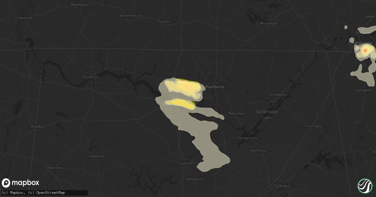
Hail Map in Madison, AL on June 25, 2023
Get this storm
June 25 map
$229
one time, instant access
Download today. No call, no setup
Keep the $229
Bought the map and want the full workflow? Apply the entire $229 to a subscription within 7 days. None of it is wasted.
Every map, not just this one
This buys you this map. Subscription and you get every map we run, in the markets you choose from a few cities to whole states to nationwide. Plus real-time alerts the moment a storm fires.
Contact data
Name, contact info, occupancy, even credit band for addresses in the footprint. You go from where it hit to who to call.
Become the source they trust
Unlimited branding weather history reports on demand. You already have the documented answer ready for the property owner, and you are the one who showed up with it.
Property data and RoofTrace estimates
Pull up any address you have got, its value and the exact code rules for that jurisdiction, straight from One Click Code. Then RoofTrace estimates the squares, pitch, and roof value, priced the way you price.
Storm reports in Madison, AL
Madison, AL
| Date | Description |
|---|---|
| 06/25/20233:00 PM CDT | Nws employee reports hail larger than quarters. |
| 06/25/20233:00 PM CDT | Report from mping: quarter |
| 06/25/20232:47 PM CDT | Report from mping: quarter |
| 06/25/20232:34 PM CDT | Report from mping: half dollar |
| 06/25/20232:29 PM CDT | Report of quarter to golf ball size hail on county line road in madison. Location estimated by radar. |
| 06/25/20232:29 PM CDT | Report from mping: half dollar |
| 06/25/20232:29 PM CDT | A gust to 69 mph was measured by the khsv asos. |
| 06/25/20232:28 PM CDT | Report from mping: quarter |
| 06/25/20232:16 PM CDT | Report from mping: quarter |
| 06/25/20231:47 PM CDT | Report from mping: quarter |
| 06/25/20231:45 PM CDT | Report from mping: quarter |
| 06/25/20231:45 PM CDT | Photo received via social media of hail larger than a quarter. |
| 06/25/20231:43 PM CDT | Report from mping: half dollar |
| 06/25/20231:42 PM CDT | Report via social media photo of penny to quarter size hail near hughes rd and gillespie rd. |
| 06/25/20231:40 PM CDT | Broadcast media report via picture on social media of quarter to half dollar size hail off of capshaw road. Location estimated by radar. |
| 06/25/20231:40 PM CDT | Spotter reported ping pong size hail along wall triana highway. Location estimated by radar. |
| 06/25/20231:39 PM CDT | Report from mping: ping pong ball |
| 06/25/20231:37 PM CDT | Spotter reported half dollar size hail near county line road and browns ferry road. |
| 06/25/20231:33 PM CDT | Social media photo report of quarter size hail at burgreen road between highway 72 and browns ferry road. Time estimated by radar. |
| 06/25/20231:33 PM CDT | Picture from social media of quarter size hail... Occurred on balch rd. Location and time estimated by radar. |
| 06/25/20231:29 PM CDT | Report from mping: quarter |
| 06/25/20231:26 PM CDT | Report from mping: quarter |
All States Impacted by Hail Map on June 25, 2023
All Cities Impacted by Hail Map on June 25, 2023
- Hawley, TX
- Merkel, TX
- Abilene, TX
- Gordonsville, TN
- Lebanon, TN
- Carthage, TN
- Hickman, TN
- Brush Creek, TN
- Alexandria, TN
- Clarkson, KY
- Cub Run, KY
- Munfordville, KY
- Rineyville, KY
- Cecilia, KY
- Chicago, IL
- Portland, TN
- Bethpage, TN
- Crossville, TN
- Mammoth Cave, KY
- Whitesville, KY
- Fordsville, KY
- Omro, WI
- Glasgow, KY
- Eighty Eight, KY
- Leitchfield, KY
- Hardinsburg, KY
- Caneyville, KY
- McDaniels, KY
- Falls Of Rough, KY
- Horse Cave, KY
- Harned, KY
- Hudson, KY
- Greensburg, KY
- Summersville, KY
- Scottsville, KY
- Lucas, KY
- Cave City, KY
- Smiths Grove, KY
- Oakland, KY
- Bowling Green, KY
- Gamaliel, KY
- Fountain Run, KY
- Holland, KY
- Lafayette, TN
- Canmer, KY
- Magnolia, KY
- Hardyville, KY
- Center, KY
- Edmonton, KY
- Tompkinsville, KY
- Hartsville, TN
- Lawrenceburg, TN
- Westmoreland, TN
- Brownsville, KY
- Summer Shade, KY
- Hawesville, KY
- Monterey, TN
- Westview, KY
- Bonnieville, KY
- Sonora, KY
- Upton, KY
- Hodgenville, KY
- Collinwood, TN
- Hilham, TN
- Livingston, TN
- Tell City, IN
- Park City, KY
- Mount Hermon, KY
- Etoile, KY
- Austin, KY
- Eastview, KY
- Glendale, KY
- Big Clifty, KY
- Elizabethtown, KY
- Celina, TN
- Rocky Hill, KY
- Hobart, IN
- Valparaiso, IN
- White House, TN
- Cottontown, TN
- Cross Plains, TN
- Gallatin, TN
- Rickman, TN
- Clarkrange, TN
- Crawford, TN
- Cookeville, TN
- Castalian Springs, TN
- Red Boiling Springs, TN
- Watertown, TN
- Athens, AL
- Harvest, AL
- Toney, AL
- Madison, AL
- Kouts, IN
- La Crosse, IN
- Wanatah, IN
- Hanna, IN
- Hamlet, IN
- Grandview, TN
- Spring City, TN
- Pikeville, TN
- Ten Mile, TN
- Decatur, TN
- Clarks Hill, IN
- Linden, IN
- Darlington, IN
- Colfax, IN
- Frankfort, IN
- Tanner, AL
- Thorntown, IN
- Lebanon, IN
- Kirklin, IN
- Knox, IN
- Grovertown, IN
- Culver, IN
- Argos, IN
- Plymouth, IN
- Bourbon, IN
- Rochester, IN
- Kewanna, IN
- Tippecanoe, IN
- Royal Center, IN
- Logansport, IN
- Burnettsville, IN
- Idaville, IN
- Lucerne, IN
- Mentone, IN
- Bremen, IN
- Nappanee, IN
- Milford, IN
- New Paris, IN
- Etna Green, IN
- Clayton, IN
- Coatesville, IN
- Danville, IN
- Amo, IN
- Fillmore, IN
- Stilesville, IN
- Mooresville, IN
- Plainfield, IN
- Bowling Green, IN
- Poland, IN
- Spencer, IN
- Brazil, IN
- Reelsville, IN
- Centerpoint, IN
- Clay City, IN
- Coal City, IN
- Patricksburg, IN
- Sheridan, IN
- Atlanta, IN
- Kempton, IN
- Tipton, IN
- Gosport, IN
- Syracuse, IN
- Millersburg, IN
- Ligonier, IN
- Cromwell, IN
- Wawaka, IN
- Kimmell, IN
- Albion, IN
- Warsaw, IN
- Akron, IN
- Silver Lake, IN
- Claypool, IN
- Saint Paul, AR
- Pettigrew, AR
- Deer, AR
- Mount Judea, AR
- Witts Springs, AR
- Marshall, AR
- Carbon Hill, AL
- Townley, AL
- Jasper, AL
- Nauvoo, AL
- Bremen, AL
- Huntsville, AL
- Decatur, AL
- Hartselle, AL
- Somerville, AL
- Churubusco, IN
- Hudson, IN
- Rome City, IN
- Ashley, IN
- Laotto, IN
- Topeka, IN
- Corunna, IN
- South Milford, IN
- Avilla, IN
- Wolcottville, IN
- Kendallville, IN
- Waterloo, IN
- Garrett, IN
- Pleasant Lake, IN
- Arcadia, IN
- Cicero, IN
- Noblesville, IN
- Anderson, IN
- Frankton, IN
- Elwood, IN
- Ellettsville, IN
- Stinesville, IN
- Bloomington, IN
- Martinsville, IN
- Leslie, AR
- Unionville, IN
- Nashville, IN
- Ozone, AR
- Hanceville, AL
- Odon, IN
- Rossville, GA
- Chattanooga, TN
- Indianapolis, IN
- Camby, IN
- Greenwood, IN
- Whiteland, IN
- Bedford, IN
- Heltonville, IN
- Loogootee, IN
- Shoals, IN
- French Lick, IN
- Boggstown, IN
- Needham, IN
- Shelbyville, IN
- Fairland, IN
- Franklin, IN
- Fountaintown, IN
- Morristown, IN
- Huntertown, IN
- Spencerville, IN
- Fort Wayne, IN
- Saint Joe, IN
- Grabill, IN
- Leo, IN
- Auburn, IN
- Butler, IN
- Hamilton, IN
- Harlan, IN
- Hicksville, OH
- Edgerton, OH
- Pioneer, OH
- Montpelier, OH
- Osseo, MI
- Bryan, OH
- Mark Center, OH
- Camden, MI
- Edon, OH
- Angola, IN
- Hillsdale, MI
- Montgomery, MI
- Fremont, IN
- Columbia City, IN
- Larwill, IN
- Timbo, AR
- Fox, AR
- Onia, AR
- Arcola, IN
- Hagarville, AR
- North Manchester, IN
- Liberty Mills, IN
- South Whitley, IN
- Huntington, IN
- Gaylord, MI
- Owensville, IN
- Fort Branch, IN
- Princeton, IN
- Cannelburg, IN
- Montgomery, IN
- Washington, IN
- Francisco, IN
- Oakland City, IN
- Winslow, IN
- West Baden Springs, IN
- Paoli, IN
- Orleans, IN
- Sturgis, KY
- Morganfield, KY
- Ozark, IL
- Herod, IL
- Eddyville, IL
- Stonefort, IL
- Goreville, IL
- Cave In Rock, IL
- Elizabethtown, IL
- Newberry, IN
- Bloomfield, IN
- Scotland, IN
- Crane, IN
- Traverse City, MI
- Grawn, MI
- Williams, IN
- Owensburg, IN
- Springville, IN
- Luther, MI
- Oolitic, IN
- Hardinsburg, IN
- Mountain View, AR
- Homer, IN
- Rushville, IN
- Manilla, IN
- Arlington, IN
- Melbourne, AR
- Fifty Six, AR
- Daleville, IN
- Yorktown, IN
- Alexandria, IN
- Pelsor, AR
- Dover, AR
- Hector, AR
- Russellville, AR
- West Unity, OH
- Sherwood, OH
- Defiance, OH
- Ney, OH
- Waldron, MI
- Archbold, OH
- Fayette, OH
- Morenci, MI
- Hudson, MI
- Alvordton, OH
- Stryker, OH
- Pittsford, MI
- Payne, OH
- Monroeville, IN
- Woodburn, IN
- New Haven, IN
- Antwerp, OH
- Cecil, OH
- Paulding, OH
- Haviland, OH
- Clinton, AR
- Bee Branch, AR
- Choctaw, AR
- Fort Oglethorpe, GA
- Seymour, IN
- Velpen, IN
- Stendal, IN
- Huntingburg, IN
- Holland, IN
- Ferdinand, IN
- Jasper, IN
- Marengo, IN
- Depauw, IN
- Milltown, IN
- Sebree, KY
- Robards, KY
- Calhoun, KY
- Clay, KY
- Dixon, KY
- Providence, KY
- Nebo, KY
- Johannesburg, MI
- New Salisbury, IN
- Ramsey, IN
- Palmyra, IN
- Fredericksburg, IN
- North Vernon, IN
- Latty, OH
- Allen, MI
- Litchfield, MI
- Oakwood, OH
- Evansport, OH
- Napoleon, OH
- Sand Creek, MI
- Wauseon, OH
- Lyons, OH
- Adrian, MI
- Clayton, MI
- Jonesville, MI
- Blissfield, MI
- Jasper, MI
- Palmyra, MI
- Britton, MI
- Delta, OH
- Homer, MI
- Concord, MI
- Hanover, MI
- Horton, MI
- Jackson, MI
- Parma, MI
- Spring Arbor, MI
- Michigan Center, MI
- Grass Lake, MI
- Munith, MI
- Vanderbilt, MI
- Corydon, IN
- Crandall, IN
- Georgetown, IN
- Greenville, IN
- Campbellsburg, IN
- Commiskey, IN
- Paris Crossing, IN
- North Judson, IN
- Owensboro, KY
- Utica, KY
- Rumsey, KY
- Manitou, KY
- Slaughters, KY
- Hanson, KY
- Madisonville, KY
- Salem, IN
- Atkins, AR
- Hattieville, AR
- Morrilton, AR
- Pottsville, AR
- Deputy, IN
- Waleska, GA
- Rydal, GA
- Canton, GA
- White, GA
- Cartersville, GA
- Woodstock, GA
- Acworth, GA
- Kennesaw, GA
- Marietta, GA
- Peachtree Corners, GA
- Smyrna, GA
- Austell, GA
- Norcross, GA
- Alpharetta, GA
- Atlanta, GA
- Roswell, GA
- Guion, AR
- Pleasant Grove, AR
- Mount Pleasant, AR
- Batesville, AR
- Marcella, AR
- Sulphur Rock, AR
- Poughkeepsie, AR
- Sidney, AR
- Cave City, AR
- Dardanelle, AR
- Adona, AR
- Perry, AR
- Lanesville, IN
- Pekin, IN
- Saint Anthony, IN
- Birdseye, IN
- Schnellville, IN
- Tucker, GA
- Scottdale, GA
- Clarkston, GA
- Stone Mountain, GA
- Decatur, GA
- Avondale Estates, GA
- New Albany, IN
- Louisville, KY
- Plumerville, AR
- Houston, AR
- South Lyon, MI
- Elizabeth, IN
- Northville, MI
- New Hudson, MI
- Novi, MI
- Wixom, MI
- Milford, MI
- Walled Lake, MI
- Solgohachia, AR
- Damascus, AR
- Cleveland, AR
- Springfield, AR
- Center Ridge, AR
- Bargersville, IN
- El Paso, AR
- Enola, AR
- Vilonia, AR
- Wooster, AR
- Greenbrier, AR
- Conway, AR
- Mount Vernon, AR
- Jacksonville, AR
- Little Rock Air Force Base, AR
- Austin, AR
- Cabot, AR
- Sherwood, AR
- Maumelle, AR
- North Little Rock, AR
- Mayflower, AR
- Bigelow, AR
- Mableton, GA
- Madison, IN
- Dupont, IN
- Ellenwood, GA
- Conley, GA
- Cord, AR
- Talladega, AL
- Munford, AL
- Saffell, AR
- Lynn, AR
- Alicia, AR
- Smithville, AR
- Strawberry, AR
- Belleville, MI
- Romulus, MI
- Wayne, MI
- New Boston, MI
- Taylor, MI
- Detroit, MI
- Westland, MI
- Dearborn Heights, MI
- Allen Park, MI
- Inkster, MI
- Dearborn, MI
- Little Rock, AR
- Scott, AR
- Taylorsville, KY
- Fairdale, KY
- Lonoke, AR
- Redfield, AR
- Hensley, AR
- England, AR
- Keo, AR
- Carlisle, AR
- Shepherdsville, KY
- Jonesboro, AR
- Newark, AR
- Tuckerman, AR
- Cash, AR
- Swifton, AR
- Charlotte, AR
- Newport, AR
- Bono, AR
- Walnut Ridge, AR
- Bay, AR
- Trumann, AR
- Harrisburg, AR
- State University, AR
- Weiner, AR
- Sunman, IN
- Guilford, IN
- Lawrenceburg, IN
- Mount Washington, KY
- Cleves, OH
- West Harrison, IN
- Harrison, OH
- Batesville, IN
- Brookville, IN
- Milan, IN
- Cedar Grove, IN
- Hazen, AR
- Altheimer, AR
- Wabbaseka, AR
- Humnoke, AR
- Tucker, AR
- Coxs Creek, KY
- Bardstown, KY
- Spencer, TN
- Fayetteville, AR
- Elkins, AR
- Muncie, IN
- Rockville, IN
- Elmwood, TN
- Grayling, MI
- Oark, AR
- Clarksville, AR
- Frederic, MI
- Mcminnville, TN
- Beersheba Springs, TN
- Altamont, TN
- Lynnville, TN
- Ringgold, GA
- Combs, AR
- Meridianville, AL
- Chesterton, IN
- Romney, IN
- Westfield, IN
- Waynetown, IN
- Wingate, IN
- Hillsboro, IN
- Crawfordsville, IN
- New Richmond, IN
- Evanston, IN
- Lamar, IN
- Santa Claus, IN
- Baileyton, AL
- Eva, AL
- Joppa, AL
- Leoma, TN
- Pulaski, TN
- Goodspring, TN
- Signal Mountain, TN
- Ellijay, GA
- Chatsworth, GA
- Ranger, GA
- Pennsauken, NJ
- Philadelphia, PA
- Lyons, IN
- Hartford, KY
- Haubstadt, IN
- Ozark, AR
- Lamar, AR
- Witter, AR
- Holland, MI
- Fennville, MI
- Hamilton, MI
- Zeeland, MI
- Coatesville, PA
- Downingtown, PA
- Cannelton, IN
- Lewisport, KY
- Taswell, IN
- Rising Fawn, GA
- Lookout Mountain, GA
- Westphalia, IN
- Sandborn, IN
- Dennard, AR
- Manchester, TN
- Quitman, AR
- Thermopolis, WY
- Harriet, AR
- Big Flat, AR
- Gruetli Laager, TN
- Charlevoix, MI
- Ellsworth, MI
- Morrison, TN
- Hillsboro, TN
- Fayette, AL
- Berry, AL
- Eldridge, AL
- Bankston, AL
- Pleasant Shade, TN
- Boaz, AL
- Terre Haute, IN
- Cory, IN
- Lancaster, TN
- Boonville, IN
- Woodbury, TN
- Hart, MI
- Shelby, MI
- New Era, MI
- Eckerty, IN
- Holly Pond, AL
- Arab, AL
- Blountsville, AL
- Estillfork, AL
- Elberfeld, IN
- Spurgeon, IN
- Lynnville, IN
- Ooltewah, TN
- Cullman, AL
- Russellville, IN
- Ladoga, IN
- Waveland, IN
- Roachdale, IN
- Kingston, AR
- Brownsburg, IN
- Pittsboro, IN
- Winchester, TN
- Estill Springs, TN
- Tallapoosa, GA
- Muscadine, AL
- Waco, GA
- Chickamauga, GA
- Rock Spring, GA
- La Fayette, GA
- Trion, GA
- Linton, IN
- Runnemede, NJ
- Audubon, NJ
- Oaklyn, NJ
- Haddon Heights, NJ
- Haddonfield, NJ
- Collingswood, NJ
- Barrington, NJ
- Mount Ephraim, NJ
- Bellmawr, NJ
- Cynthiana, IN
- English, IN
- Roann, IN
- South Pittsburg, TN
- Sewanee, TN
- Elnora, IN
- Shawneetown, IL
- Junction, IL
- Ridgway, IL
- Ohatchee, AL
- Shelbyville, TN
- Lookout Mountain, TN
- Flintstone, GA
- Minor Hill, TN
- Tennyson, IN
- Chrisney, IN
- Riley, IN
- Mitchell, IN
- Twelve Mile, IN
- Dixon Springs, TN
- Riddleton, TN
- Cornersville, TN
- Granger, IN
- Niles, MI
- Granville, TN
- Buffalo Valley, TN
- Chestnut Mound, TN
- Au Gres, MI
- Monterey, IN
- San Pierre, IN
- Wheatfield, IN
- Leesburg, IN
- Liberty, TN
- Burket, IN
- Gibbsboro, NJ
- Voorhees, NJ
- Clementon, NJ
- Somerdale, NJ
- Magnolia, NJ
- Stratford, NJ
- Blackwood, NJ
- Woodbury, NJ
- Glendora, NJ
- Elkmont, AL
- Equality, IL
- Harrisburg, IL
- Eldorado, IL
- Ora, IN
- Walkerton, IN
- Laceys Spring, AL
- Chandler, IN
- Evansville, IN
- Gentryville, IN
- Richland, IN
- Newburgh, IN
- Ardmore, TN
- Loretto, TN
- Five Points, TN
- Falkville, AL
- Calhoun, GA
- Gainesboro, TN
- Bloomington Springs, TN
- Odenville, AL
- Pell City, AL
- Havre De Grace, MD
- Medora, IN
- Vinemont, AL
- Ardmore, AL
- Perryville, AR
- Lewisburg, TN
- Columbia, TN
- Belvidere, TN
- Bradyville, TN
- Fruithurst, AL
- Corydon, KY
- Waverly, KY
- Henderson, KY
- Uniontown, KY
- Macy, IN
- Sedan, KS
- Kalkaska, MI
- Guntersville, AL
- Union Grove, AL
- Allendale, MI
- Coopersville, MI
- Omaha, IL
- Armuchee, GA
- Summerville, GA
- Sugar Valley, GA
- Auburntown, TN
- Sharpsville, IN
- Continental, OH
- Dayton, TN
- Whitwell, TN
- Tracy City, TN
- Rocky Face, GA
- Toccoa, GA
- Valhermoso Springs, AL
- Trinity, AL
- Poseyville, IN
- Albertville, AL
- Crossville, AL
- North Liberty, IN
- Guild, TN
- Smithville, TN
- Waldron, IN
- Huntsville, AR
- Ponca, AR
- Steele, AL
- Gallant, AL
- Attalla, AL
- Beechgrove, TN
- Pierceton, IN
- Immokalee, FL
- Whiteside, TN
- Greencastle, IN
- Evensville, TN
- Rapid City, MI
- Aberdeen, MD
- Darlington, MD
- Churchville, MD
- Wheatland, IN
- Philpot, KY
- Hixson, TN
- Taft, TN
- Fayetteville, TN
- Hazel Green, AL
- Bruceville, IN
- Vincennes, IN
- Plainville, IN
- Monroe City, IN
- Dubois, IN
- Bicknell, IN
- Brownstown, IN
- Norman, IN
- Freetown, IN
- Laketon, IN
- Winona Lake, IN
- North Webster, IN
- Bristow, IN
- Dowelltown, TN
- Silver Point, TN
- New Middletown, IN
- Iron City, TN
- Saint Joseph, TN
- Lester, AL
- Westpoint, TN
- Prospect, TN
- Standish, MI
- Omer, MI
- Germansville, PA
- Slatington, PA
- West Newton, IN
- Solsberry, IN
- Westville, IN
- Marked Tree, AR
- Lake City, AR
- Caraway, AR
- Lepanto, AR
- Dyess, AR
- Wilson, AR
- Joiner, AR
- Frenchmans Bayou, AR
- Turrell, AR
- Gilmore, AR
- Bassett, AR
- Tyronza, AR
- Okeana, OH
- Hamilton, OH
- Oxford, OH
- Bloomfield, KY
- Allenton, MI
- Almont, MI
- Capac, MI
- Imlay City, MI
- De Witt, AR
- Humphrey, AR
- Ulm, AR
- Gillett, AR
- Almyra, AR
- Stuttgart, AR
- Clarendon, AR
- Crocketts Bluff, AR
- Holly Grove, AR
- Casscoe, AR
- Roe, AR
- De Valls Bluff, AR
- Fremont, OH
- Vickery, OH
- Clyde, OH
- Port Clinton, OH
- Oak Harbor, OH
- Lacarne, OH
- Lindsey, OH
- Elmore, OH
- Woodville, OH
- Gibsonburg, OH
- Helena, OH
- Burgoon, OH
- Green Springs, OH
- Castalia, OH
- Sandusky, OH
- Huron, OH
- Bellevue, OH
- Lakeside Marblehead, OH
- Kelleys Island, OH
- Memphis, TN
- Drummonds, TN
- Munford, TN
- Atoka, TN
- Marion, AR
- Crawfordsville, AR
- Arlington, TN
- Millington, TN
- Goshen, KY
- Prospect, KY
- Charlestown, IN
- Jeffersonville, IN
- Cropwell, AL
- Vincent, AL
- Childersburg, AL
- Alpine, AL
- Sylacauga, AL
- Goodwater, AL
- Crestwood, KY
- Pewee Valley, KY
- La Grange, KY
- Buckner, KY
- Smithfield, KY
- Simpsonville, KY
- Fisherville, KY
- Cordova, TN
- Eads, TN
- Ethel, AR
- Saint Charles, AR
- Tichnor, AR
- Snow Lake, AR
- Mellwood, AR
- Elaine, AR
- Lexa, AR
- Shelby, MS
- Marvell, AR
- Crumrod, AR
- Clarksdale, MS
- Duncan, MS
- Alligator, MS
- Gunnison, MS
- Helena, AR
- Poplar Grove, AR
- Clarksville, IN
- Troy, IN
- Saint Meinrad, IN
- Leavenworth, IN
- Leopold, IN
- Branchville, IN
- Battletown, KY
- Mauckport, IN
- Central, IN
- Glenview, KY
- Masonic Home, KY
- Shelbyville, KY
- Frankfort, KY
- Waddy, KY
- Lawrenceburg, KY
- Bagdad, KY
- Tutwiler, MS
- Sumner, MS
- Drew, MS
- Mound Bayou, MS
- Merigold, MS
- Parchman, MS
- Ruleville, MS
- Cleveland, MS
- Charleston, MS
- Union Star, KY
- Stephensport, KY
- Rome, IN
- Webster, KY
- Rockport, IN
- Grandview, IN
- Maceo, KY
- Derby, IN
- Spottsville, KY
- Reed, KY
- Irvington, KY
- Schlater, MS
- Minter City, MS
- Doddsville, MS
- Glendora, MS
- Cascilla, MS
- Greenwood, MS
- Philipp, MS
- Holcomb, MS
- Michigan City, MS
- Ashland, MS
- Falkner, MS
- Walnut, MS
- Moscow, TN
- Lamar, MS
- Grand Junction, TN
- Tiplersville, MS
- Blue Mountain, MS
- New Albany, MS
- Ripley, MS
- Holly Springs, MS
- Hickory Flat, MS
- Dumas, MS
- Booneville, MS
- Guntown, MS
- Baldwyn, MS
- Rienzi, MS
- Saltillo, MS
- Blue Springs, MS
- Water Valley, MS
- Oxford, MS
- Paris, MS
- Versailles, KY
- Guston, KY
- Payneville, KY
- Mantachie, MS
- Tupelo, MS
- New Site, MS
- Belmont, MS
- Fulton, MS
- Tishomingo, MS
- Marietta, MS
- Dennis, MS
- Banner, MS
- Randolph, MS
- Pontotoc, MS
- Itta Bena, MS
- Sidon, MS
- Carrollton, MS
- Clinton, KY
- Houlka, MS
- Bruce, MS
- Golden, MS
- Mooreville, MS
- Nettleton, MS
- Tremont, MS
- Coila, MS
- Vine Grove, KY
- Lexington, KY
- Nicholasville, KY
- Wingo, KY
- Mayfield, KY
- Sedalia, KY
- Richmond, KY
- West, MS
- Lexington, MS
- Durant, MS
- Ethel, MS
- Vaiden, MS
- Winona, MS
- North Carrollton, MS
- McCarley, MS
- Smithville, MS
- Salvisa, KY
- Harrodsburg, KY
- Lancaster, KY
- Wilmore, KY
- Burgin, KY
- Berea, KY
- Paint Lick, KY
- Waco, KY
- Olaton, KY
- Horse Branch, KY
- Dundee, KY
- Cruger, MS
- Louise, MS
- Isola, MS
- Tchula, MS
- Silver City, MS
- Inverness, MS
- Hollandale, MS
- Greenville, MS
- Anguilla, MS
- Leland, MS
- Indianola, MS
- Belzoni, MS
- Moorhead, MS
- Shaw, MS
- Sunflower, MS
- Benoit, MS
- Rohwer, AR
- Eudora, AR
- Dermott, AR
- Arkansas City, AR
- McGehee, AR
- Lake Village, AR
- Yazoo City, MS
- Holly Bluff, MS
- Glen Allan, MS
- Rolling Fork, MS
- Irvine, KY
- McKee, KY
- Sweeden, KY
- Bee Spring, KY
- Hot Springs Village, AR
- Hot Springs National Park, AR
- Mountain Pine, AR
- Mayersville, MS
- Satartia, MS
- Chatham, MS
- Benton, MS
- Tinsley, MS
- Bolton, MS
- Bentonia, MS
- Pickens, MS
- Goodman, MS
- Sallis, MS
- Vaughan, MS
- Knob Lick, KY
- Campbellsville, KY
- Vincent, KY
- Booneville, KY
- Beattyville, KY
- Jackson, MS
- Madison, MS
- Flora, MS
- Canton, MS
- Camden, MS
- Carthage, MS
- Kosciusko, MS
- Malvern, AR
- Lena, MS
- Ridgeland, MS
- Brandon, MS
- Tougaloo, MS
- Clinton, MS
- Ricetown, KY
- Breeding, KY
- Gradyville, KY
- Columbia, KY
- Glens Fork, KY
- Knifley, KY
- Russell Springs, KY
- Warren, AR
- Wilmar, AR
- Jamestown, KY
- Flowood, MS
- Pearl, MS
- Richland, MS
- Florence, MS
- Braxton, MS
- Pelahatchie, MS
- Morton, MS
- Forest, MS
- Mendenhall, MS
- Pinola, MS
- Monticello, AR
- Donaldson, AR
- Pearcy, AR
- Bonnerdale, AR
- Coal Hill, AR
- Altus, AR
- Scranton, AR
- Hartman, AR
- Lexington, IN
- Scottsburg, IN
- Bowling Green, OH
- Rison, AR
- Lewiston, CA
- Cedartown, GA
- Van Wert, OH
- Willshire, OH
- Ohio City, OH
- Wren, OH
- Convoy, OH
- Tuskegee, AL
- Notasulga, AL
- Tallassee, AL
- Cadillac, MI
- Robertsdale, AL
- Lockport, KY
- Bethlehem, KY
- Owenton, KY
- Campbellsburg, KY
- Dansville, MI
- Eastaboga, AL
- Benton, KY
- Kirksey, KY
- Sheridan, AR
- Latham, NY
- Watervliet, NY
- Albany, NY
- Wellington, AL
- Aurora, IN
- Austin, IN
- Crothersville, IN
- Bedford, KY
- Bethlehem, IN
- Pendleton, KY
- Nabb, IN
- Hanover, IN
- Portsmouth, VA
- Chesapeake, VA
- Watson, AR
- Cragford, AL
- Alexander City, AL
- Ashland, AL
- Daviston, AL
- Milton, KY
- Carrollton, KY
- Hartford City, IN
- Mancelona, MI
- Elmira, MI
- Berlin, NJ
- Sicklerville, NJ
- Millwood, KY
- Reynolds Station, KY
- Vincentown, NJ
- West Berlin, NJ
- Atco, NJ
- Danville, AR
- Belleville, AR
- Morgantown, KY
- Stamping Ground, KY
- Pinson, AL
- Trussville, AL
- Plymouth, MI
- Holgate, OH
- Ottawa, OH
- Hamler, OH
- Miller City, OH
- Deshler, OH
- New Bavaria, OH
- Leipsic, OH
- Jetson, KY
- Roundhill, KY
- Laingsburg, MI
- Brandenburg, KY
- Chesaning, MI
- Oakley, MI
- Saint Croix, IN
- Rhodelia, KY
- Lonsdale, AR
- Water Valley, KY
- Fulton, KY
- Lineville, AL
- Mabelvale, AR
- Buchanan, GA
- Villa Rica, GA
- Tillar, AR
- Hoxie, AR
- New Castle, KY
- Pleasureville, KY
- Delaware, AR
- Rockmart, GA
- Bremen, GA
- Temple, GA
- Dallas, GA
- Douglasville, GA
- Winston, GA
- Memphis, IN
- Borden, IN
- Henryville, IN
- Lebanon, KY
- Danville, AL
- Wedowee, AL
- Woodland, AL
- Kingsland, AR
- Bismarck, AR
- Norfolk, VA
- Virginia Beach, VA
- Casa, AR
- Knoxville, AR
- Ola, AR
- London, AR
- Altoona, AL
- Alexander, AR
- White Hall, AR
- Bryant, AR
- Bauxite, AR
- New Liberty, KY
- Worthville, KY
- Sanders, KY
- Centre, AL
- Piedmont, AL
- Paron, AR
- Plainview, AR
- Chaplin, KY
- Brooks, KY
- Monroe, IN
- Berne, IN
- Columbus, IN
- Owosso, MI
- Fort Knox, KY
- New Edinburg, AR
- Chatsworth, NJ
- Browns Mills, NJ
- Decatur, IN
- Bowdon, GA
- Shorter, AL
- Danville, KY
- Hermitage, AR
- Hamburg, AR
- Rover, AR
- Montague, CA
- Fairburn, GA
- Palmetto, GA
- Alexandria, AL
- Kellyton, AL
- Rockford, AL
- Bound Brook, NJ
- Middlesex, NJ
- Martinsville, NJ
- Dunellen, NJ
- Warren, NJ
- Lincoln, AL
- Heflin, AL
- Harpersville, AL
- Weed, CA
- Ekron, KY
- Custer, KY
- Radcliff, KY
- Beebe, AR
- Ragland, AL
- Anniston, AL
- Riverside, AL
- Equality, AL
- Oxford, AL
- Farmington, MI
- Auburn, AL
- Jessieville, AR
- Willisburg, KY
- Finchville, KY
- Briggsville, AR
- Sulphur, IN
- Star City, AR
- Haslett, MI
- East Lansing, MI
- Harrisville, MS
- Raleigh, MS
- Louin, MS
- Magee, MS
- Pulaski, MS
- Lake, MS
- Fairfield, KY
- Turners Station, KY
- Buffalo, KY
- Pemberville, OH
- Jacksonville, AL
- New Blaine, AR
- Grapevine, AR
- Stanford, KY
- Vallonia, IN
- Pine Bluff, AR
- Boyle, MS
- Murray, KY
- Farmington, KY
- Hazel, KY
- Laconia, IN
- Westport, KY
- Sulphur, KY
- Sellersburg, IN
- Mount Eden, KY
- Underwood, IN
- Floyds Knobs, IN
- Springfield, KY
- Mackville, KY
- Otisco, IN
- Grantsburg, IN
- Monticello, KY
- Nancy, KY
- Alpha, KY
- Bronston, KY
- Leola, AR
- Mize, MS
- Taylorsville, MS
- Prentiss, MS
- Newhebron, MS
- Mount Olive, MS
- Stringer, MS
- Bay Springs, MS
- Collins, MS
- Laurel, MS
- Soso, MS
- Sumrall, MS
- Seminary, MS
- Bassfield, MS
- Ellisville, MS
- Moselle, MS
- Carson, MS
- Arkadelphia, AR
- Stearns, KY
- Whitley City, KY
- Burnside, KY
- Corbin, KY
- Rockholds, KY
- Williamsburg, KY
- Barbourville, KY
- Woodbine, KY
- Siler, KY
- Pineville, KY
- Frakes, KY
- Bryants Store, KY
- Calvin, KY
- Trosper, KY
- Amity, AR
- Harrell, AR
- Hampton, AR
- Ovett, MS
- Richton, MS
- Petal, MS
- Beaumont, MS
- New Augusta, MS
- State Line, MS
- Waynesboro, MS
- Middlesboro, KY
- New Tazewell, TN
- Speedwell, TN
- Cumberland Gap, TN
- Ewing, VA
- Harrogate, TN
- Tazewell, TN
- Thorn Hill, TN
- Rutledge, TN
- Washburn, TN
- Bean Station, TN
- Kirby, AR
- Delight, AR
- Dandridge, TN
- Morristown, TN
- Jefferson City, TN
- Talbott, TN
- White Pine, TN
- Newport, TN
- Cosby, TN
- Parrottsville, TN
- Bybee, TN
- Del Rio, TN
- Neely, MS
- McLain, MS
- Leakesville, MS
- Wilmer, AL
- Lucedale, MS
- Citronelle, AL
- Chunchula, AL
- Vinegar Bend, AL
- Hartford, TN
- Valliant, OK
- Ringold, OK
- Hooks, TX
- Texarkana, TX
- Ashdown, AR
- Livonia, MI
- Broken Bow, OK
- Casper, WY
- Glenns Ferry, ID
- Eutaw, AL
- Parkdale, AR
- Auburn, KY
- Portland, AR
- Lewisburg, KY
- Greenville, KY
- Belton, KY
- Norman, AR
- Aberdeen, MS
- Prairie, MS
- Amory, MS
- Hamilton, MS
- Dexter, KY
- Hardin, KY
- Almo, KY
- Franklin, KY
- Nashville, AR
- Ozan, AR
- Murfreesboro, AR
- Alvaton, KY
- Rochester, KY
- Oneonta, AL
- Troy, AL
- Perryville, KY
- Thomasville, AL
- Centertown, KY
- Central City, KY
- Bremen, KY
- Highland Home, AL
- Grady, AL
- Luverne, AL
- Wilmot, AR
- Jones, LA
- Adolphus, KY
- Winfield, AL
- Mount Holly, AR
- Smackover, AR
- Rattan, OK
- Okolona, AR
- Antoine, AR
- Burkesville, KY
- Chidester, AR
- Gurdon, AR
- Prescott, AR
- Dawson Springs, KY
- Elba, AL
- Goshen, AL
- Glenwood, AL
- Lake Providence, LA
- Sweet Water, AL
- Rensselaer, NY
- Troy, NY
- Springville, AL
- Banks, AR
- Ramer, AL
- Camden, AR
- Mount Ida, AR
- Royal, AR
- Friendship, AR
- Sulligent, AL
- Byram, MS
- Buckatunna, MS
- Springfield, TN
- Umpire, AR
- Mena, AR
- Union Springs, AL
- Fitzpatrick, AL
- Pemberton, NJ
- Kinston, AL
- Edgemont, SD
- Bluff City, AR
- Woodburn, KY
- Counce, TN
- Savannah, TN
- Story, AR
- Greenville, AL
- Beaumont, KY
- Eupora, MS
- Walthall, MS
- New Madrid, MO
- Crossett, AR
- Fountain Hill, AR
- Stephens, AR
- Columbus, MS
- Garvin, OK
- Raywick, KY
- Fordyce, AR
- Poyen, AR
- Bearden, AR
- Sparkman, AR
- Carthage, AR
- Thornton, AR
- Montrose, AR
- Eagletown, OK
- Horton, AL
- Earlington, KY
- Princeton, KY
- Kennedy, AL
- Hattiesburg, MS
- East Prairie, MO
- Wright City, OK
- Fort Towson, OK
- El Dorado, AR
- Oakman, AL
- Starkville, MS
- Caddo Gap, AR
- Langley, AR
- Shubuta, MS
- Blevins, AR
- McCaskill, AR
- Newhope, AR
- Glenwood, AR
- Burna, KY
- Nashoba, OK
- Hatfield, AR
- Beaverton, AL
- Beaver Dam, KY
- Henderson, TN
- Finger, TN
- Gilbertown, AL
- Melvin, AL
- Russellville, KY
- Vicksburg, MS
- White Plains, KY
- Nortonville, KY
- Idabel, OK
- Brantley, AL
- Samson, AL
- Cromwell, KY
- Rockport, KY
- McHenry, KY
- Marion, KY
- Fredonia, KY
- Greenwood Springs, MS
- Mathiston, MS
- West Point, KY
- Sacramento, KY
- Drakesboro, KY
- Tuskegee Institute, AL
- Salem, KY
- Prattsville, AR
- Burnsville, MS
- Sandgap, KY
- Haworth, OK
- Nash, TX
- Rosston, AR
- McNeil, AR
- Cohoes, NY
- Yorktown, AR
- Wetumpka, AL
- Coffeeville, MS
- Quitman, MS
- Clayton, OK
- Crab Orchard, KY
- Fouke, AR
- Texarkana, AR
- Queen City, TX
- Doddridge, AR
- Bloomburg, TX
- Ida, LA
- Gilliam, LA
- Plain Dealing, LA
- Bradley, AR
- Benton, LA
- Cotton Valley, LA
- Sarepta, LA
- Minden, LA
- Lance Creek, WY
- Shreveport, LA
- Marion, LA
- Emmet, AR
- Lewisville, AR
- Homer, LA
- Athens, LA
- Vancleave, MS
- Lusk, WY
- Jackson, AL
- Saint Stephens, AL
- Maud, TX
- Junction City, AR
- Hope, AR
- Bastrop, LA
- Haynesville, LA
- Arcadia, LA
- Shongaloo, LA
- Gibsland, LA
- Oak Grove, LA
- Gulf Breeze, FL
- Jersey, AR
- Waldo, AR
- Willisville, AR
- Buckner, AR
- Milroy, IN
- Magnolia, AR
- Harrison, NE
- New Boston, TX
- Dierks, AR
- Lockesburg, AR
- Mineral Springs, AR
- Simsboro, LA
- Huttig, AR
- Monroeville, AL
- Peterman, AL
- Fulton, AR
- Emerson, AR
- Lafayette, IN
- Lexington, TN
- Reagan, TN
- De Queen, AR
- Foreman, AR
- Pennington, AL
- Navarre, FL
- Pine Hill, AL
- Lower Peach Tree, AL
- Eglin Afb, FL
- Linden, AL
- Mooringsport, LA
- Saratoga, AR
- Gainestown, AL
- Horatio, AR
- Whatley, AL
- Franklin, AL
- Repton, AL
- Coden, AL
- Needham, AL
- Butler, AL
- Silas, AL
- Bonita, LA
- Sardis, AL
- Evergreen, AL
- Tallulah, LA
- De Kalb, TX
- Jacks Creek, TN
- Enville, TN


