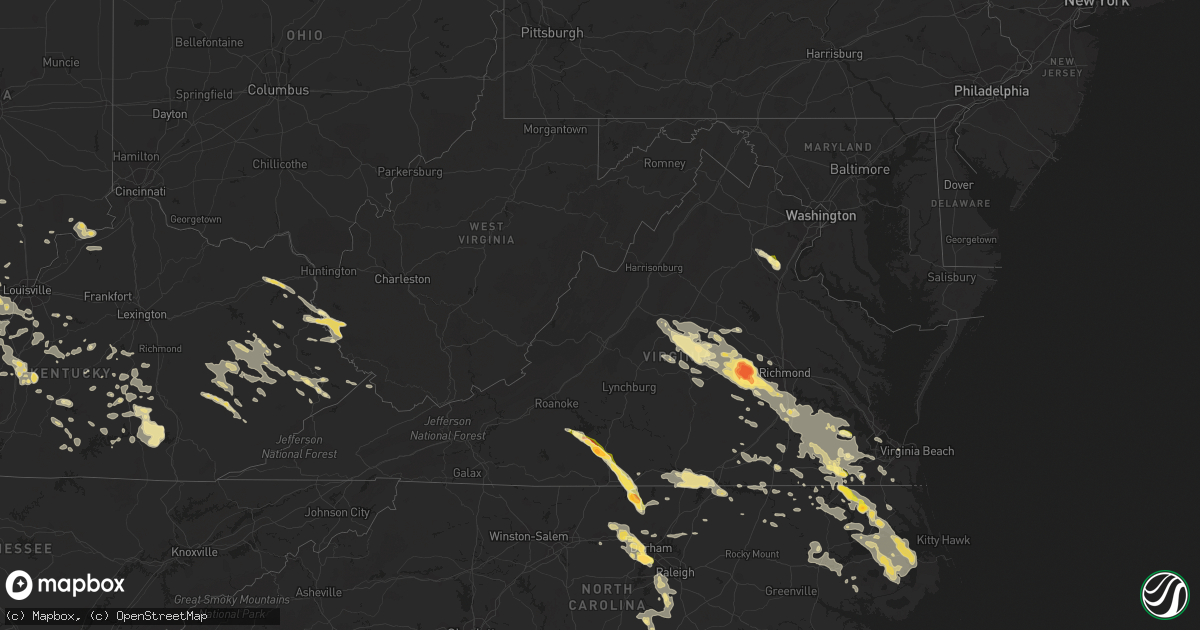
Hail Map in Virginia on June 25, 2015
Get this storm
June 25 map
$229
one time, instant access
Download today. No call, no setup
Keep the $229
Bought the map and want the full workflow? Apply the entire $229 to a subscription within 7 days. None of it is wasted.
Every map, not just this one
This buys you this map. Subscription and you get every map we run, in the markets you choose from a few cities to whole states to nationwide. Plus real-time alerts the moment a storm fires.
Contact data
Name, contact info, occupancy, even credit band for addresses in the footprint. You go from where it hit to who to call.
Become the source they trust
Unlimited branding weather history reports on demand. You already have the documented answer ready for the property owner, and you are the one who showed up with it.
Property data and RoofTrace estimates
Pull up any address you have got, its value and the exact code rules for that jurisdiction, straight from One Click Code. Then RoofTrace estimates the squares, pitch, and roof value, priced the way you price.
Storm reports in Virginia
Virginia
| Date | Description |
|---|---|
| 06/25/20156:45 PM CDT | Tree downed onto a power line along old hundred road va-10 in chesterfield |
| 06/25/20156:00 PM CDT | Large tree downed on hull street road at brandermill |
| 06/25/20155:35 PM CDT | Spotter observed ping-pong ball sized hail at his home. |
| 06/25/20154:41 PM CDT | 1 inch hail along marion rd |
| 06/25/20154:39 PM CDT | 1 inch hail along hodnetts mill rd. Outside of chatham... Va. |
| 06/25/20154:30 PM CDT | A local report indicates 1.00 inch wind near CARRSVILLE |
| 06/25/20154:30 PM CDT | A local report indicates 1.00 inch wind near 1 S CLIMAX |
| 06/25/20154:27 PM CDT | Golf ball sized hail sw of climax... Va. |
| 06/25/20154:15 PM CDT | A local report indicates 1.00 inch wind near HUNTERDALE |
| 06/25/20154:00 PM CDT | A local report indicates 1.00 inch wind near WINDSOR |
| 06/25/20153:53 PM CDT | 1 inch hail |
| 06/25/20153:10 PM CDT | Trees down and roof damage at a trailer park |
| 06/24/201511:55 PM CDT | 4 to 6 inch diameter tree branch downed along us-58 in suffolk near pitchkettle road |
| 06/24/201511:30 PM CDT | Large power transformer blown down on buffalo ave in norfolk |
| 06/24/20159:35 PM CDT | Powerlines down on lamore drive in prince george |
| 06/24/20159:30 PM CDT | Trees and power lines down on old hundred road from previous line of storms |
| 06/24/20159:30 PM CDT | A local report indicates 70 MPH wind near RICHMOND |
| 06/24/20159:10 PM CDT | Numerous powerlines down on sutherland road. Scattered power outages. |
| 06/24/20159:05 PM CDT | A local report indicates 1.25 inch wind near CLAYVILLE |
| 06/24/20159:00 PM CDT | Small tree limbs down |
| 06/24/20158:57 PM CDT | A local report indicates 1.75 inch wind near PLAIN VIEW |
| 06/24/20158:55 PM CDT | A local report indicates 1.25 inch wind near CLAYVILLE |
| 06/24/20158:45 PM CDT | A local report indicates 1.75 inch wind near FLAT ROCK |
| 06/24/20158:40 PM CDT | Tree down. |
| 06/24/20158:30 PM CDT | Trees down in numerous locations along broad street in henrico. Time is radar estimated. |
| 06/24/20158:30 PM CDT | A local report indicates 3.00 inch wind near POWHATAN |
| 06/24/20158:30 PM CDT | A local report indicates 1.00 inch wind near 1 NE HEFLIN |
| 06/24/20158:10 PM CDT | Trees down north end of county near rt. 45. |
| 06/24/20158:10 PM CDT | 5 trees down along highway 20 near scottsville. |
| 06/24/20158:06 PM CDT | Multiple trees down near the 300 block of irish rd |
| 06/24/20158:00 PM CDT | Spotter reported multiple trees down off of rt 718. Time is estimated by radar |
| 06/24/20158:00 PM CDT | Several trees downed in fork union. Time radar estimated. |
| 06/24/20157:43 PM CDT | Trees down near intersesction of albevanna spring rd and solo dr |
| 06/24/20157:34 PM CDT | Trees down near intersection of scottsville rd and red hill rd |
| 06/24/20157:32 PM CDT | Few trees down near intersection of old lynchburg rd and richland dr |
| 06/24/20157:29 PM CDT | Trees down near 4100 block of monacan trail rd |
| 06/24/20157:15 PM CDT | Several trees down near intersection of langford dr and dick woods rd |
| 06/24/20157:15 PM CDT | Trees down near craigs store rd and black oak ridge |
| 06/24/20157:12 PM CDT | Trees downed on venable road. Time is radar estimated. |
| 06/24/20157:11 PM CDT | Tree down near intersection of owensville rd and tilman rd |
| 06/24/20157:10 PM CDT | Numerous medium to large sized tree limbs down |
All States Impacted by Hail Map on June 25, 2015
Cities Impacted by Hail Map on June 25, 2015
- Dawson, NE
- Stella, NE
- Humboldt, NE
- Table Rock, NE
- Verdon, NE
- Mankato, KS
- Formoso, KS
- Harrisburg, MO
- Columbia, MO
- Bennett, CO
- La Salle, CO
- Strasburg, CO
- Keenesburg, CO
- Hudson, CO
- McDowell, KY
- Grethel, KY
- San Jose, NM
- Harrisburg, NE
- Bayard, NE
- Yuma, CO
- Eckley, CO
- Wray, CO
- Bridgeport, NE
- Chapel Hill, NC
- Durham, NC
- Topeka, KS
- Gravois Mills, MO
- Edwards, MO
- Stover, MO
- Climax Springs, MO
- Edgemont, SD
- Hanover, KS
- Bremen, KS
- Buckner, MO
- Sibley, MO
- Independence, MO
- Beattie, KS
- Oketo, KS
- Liberty, NE
- Hettick, IL
- Palmyra, IL
- Greenfield, IL
- Oakley, KS
- Winona, KS
- Montezuma, KS
- New Baden, IL
- Albers, IL
- Okawville, IL
- Tyner, KY
- Manchester, KY
- Sizerock, KY
- Sextons Creek, KY
- Bear Branch, KY
- Oneida, KY
- Booneville, KY
- Kingston, GA
- Horton, KS
- Hiawatha, KS
- Everest, KS
- Holly, CO
- Sublette, KS
- Satanta, KS
- Wallace, KS
- Magnolia, KY
- Buffalo, KY
- Mount Sherman, KY
- Rockbridge, IL
- Waldo, KS
- Paradise, KS
- Sedley, VA
- Louisa, KY
- Hay Springs, NE
- Booker, TX
- Perryton, TX
- Balko, OK
- Venice, IL
- Madison, IL
- Granite City, IL
- East Saint Louis, IL
- Lusk, WY
- Manville, WY
- Ellsworth, NE
- Bonnie, IL
- Johnsonville, IL
- Opdyke, IL
- Kell, IL
- Ina, IL
- Mount Vernon, IL
- Bluford, IL
- Centralia, IL
- Texico, IL
- Belle Rive, IL
- Salem, IL
- Iuka, IL
- Keenes, IL
- Harrodsburg, KY
- Lancaster, KY
- Danville, KY
- Marienthal, KS
- Suffolk, VA
- Barnes, KS
- Waterville, KS
- Randolph, KS
- Garfield, KY
- Harned, KY
- Pendleton, NC
- Como, NC
- Cartersville, GA
- Lithia, FL
- Bowling Green, FL
- Mulberry, FL
- Courtland, VA
- Ivor, VA
- Wakefield, VA
- Carrsville, VA
- Waverly, VA
- Franklin, VA
- Clarksville, VA
- Delia, KS
- Junction City, KS
- Troy, IL
- O'Fallon, IL
- Lebanon, IL
- Collinsville, IL
- Robinson Creek, KY
- Pikeville, KY
- Deer Trail, CO
- Marshall, MO
- Slater, MO
- Sweet Springs, MO
- Great Bend, KS
- Rush Center, KS
- Hoisington, KS
- Pawnee Rock, KS
- Larned, KS
- Albert, KS
- Otis, KS
- Olmitz, KS
- Saint Joseph, MO
- Coulterville, IL
- Corydon, IN
- Cedartown, GA
- Rozel, KS
- Scottsville, VA
- Moseley, VA
- Midlothian, VA
- Powhatan, VA
- Ulmer, SC
- Nunn, CO
- Cheyenne, WY
- Ault, CO
- Shelbiana, KY
- Elkhorn City, KY
- Alliance, NE
- Carbondale, KS
- Falls Of Rough, KY
- Lillington, NC
- Broadway, NC
- Chula, MO
- Trenton, MO
- Turtle Lake, ND
- Mercer, ND
- Washburn, ND
- Wilton, ND
- New Cambria, MO
- Callao, MO
- Cary, NC
- Burlington, NC
- Carrboro, NC
- Mebane, NC
- Morrisville, NC
- Cedar Grove, NC
- Hillsborough, NC
- Apex, NC
- Efland, NC
- Farmersville, IL
- Girard, IL
- Keystone, SD
- Rapid City, SD
- Hermosa, SD
- St John, KS
- Greenville, IN
- Georgetown, IN
- Keaton, KY
- Flatgap, KY
- West Liberty, KY
- Bahama, NC
- Gatesville, NC
- Gates, NC
- Lakeland, FL
- Williamsburg, KS
- Pomona, KS
- Hardinsburg, KY
- Cannelton, IN
- Cloverport, KY
- Oak Grove, MO
- Bates City, MO
- Campbellsville, KY
- Lance Creek, WY
- Blue Springs, NE
- Wymore, NE
- Gypsum, KS
- Seibert, CO
- Howe, IN
- Shipshewana, IN
- Wolcottville, IN
- Lagrange, IN
- Auxvasse, MO
- Dillwyn, VA
- Buckingham, VA
- Beaver, OK
- Franktown, CO
- Columbia, NC
- Lagrange, WY
- Nashville, IL
- Edenton, NC
- Hertford, NC
- Colerain, NC
- Tyner, NC
- Trementina, NM
- Salyersville, KY
- Cimarron, KS
- Sheridan Lake, CO
- Lamar, CO
- Upton, WY
- Sidney, NE
- Cuba, AL
- Toomsuba, MS
- Santa Claus, IN
- Lamar, IN
- Walterboro, SC
- Ruffin, SC
- Blackburn, MO
- Henderson, NC
- Boydton, VA
- Hemingford, NE
- Chillicothe, MO
- Concordia, KS
- Emporia, VA
- Syracuse, KS
- Macon, NC
- Norlina, NC
- Warrenton, NC
- Prince George, VA
- Stafford, VA
- Leasburg, NC
- Roxboro, NC
- Mandan, ND
- Whitney, NE
- Burns, WY
- Esmont, VA
- Schuyler, VA
- Arvonia, VA
- Keene, VA
- Palmyra, VA
- Bremo Bluff, VA
- Howardsville, VA
- New Canton, VA
- Chadron, NE
- Copeland, KS
- Colorado Springs, CO
- Princeton, KY
- Fredonia, KY
- Gasburg, VA
- White Plains, VA
- Littleton, NC
- Henrico, NC
- Campbellsburg, IN
- Sonora, KY
- Glendale, KY
- Hodgenville, KY
- Elizabethtown, KY
- Hugoton, KS
- Liberal, KS
- Kiowa, CO
- Malta Bend, MO
- Taylorsville, KY
- Boise City, OK
- Myakka City, FL
- Bernalillo, NM
- Algodones, NM
- Parrish, FL
- Crawford, NE
- Glenvil, NE
- Glendo, WY
- Hartville, WY
- Jay Em, WY
- Thousandsticks, KY
- Hyden, KY
- Fayette, MS
- Kansas City, KS
- Kit Carson, CO
- Cheyenne Wells, CO
- Eugene, MO
- Gladstone, NM
- Carpenter, WY
- Hillsdale, WY
- Center, ND
- Piedmont, AL
- Eolia, MO
- Bowling Green, MO
- Church Road, VA
- Amelia Court House, VA
- Leoti, KS
- Moscow, KS
- Grafton, IL
- Bardstown, KY
- Beloit, KS
- Winfield, MO
- Old Monroe, MO
- Hobbsville, NC
- Belvidere, NC
- Morganville, KS
- Clyde, KS
- Saint Thomas, MO
- Westphalia, MO
- Meta, MO
- Jefferson City, MO
- Hasty, CO
- Jameson, MO
- Pattonsburg, MO
- Madrid, NE
- Soldier, KS
- Dodge City, KS
- Wright, KS
- Jetmore, KS
- Okeechobee, FL
- Cairo, MO
- Excello, MO
- Jacksonville, MO
- Moberly, MO
- Mineral, VA
- Louisa, VA
- New Middletown, IN
- Elizabeth, IN
- Semora, NC
- Lees Summit, MO
- Levasy, MO
- Liberty, MO
- Pleasant Hill, MO
- Orrick, MO
- Holden, MO
- Greenwood, MO
- Wellington, MO
- Grain Valley, MO
- Strasburg, MO
- Blue Springs, MO
- Centerview, MO
- Mayview, MO
- Lexington, MO
- Lone Jack, MO
- Kansas City, MO
- Odessa, MO
- Smithville, MO
- Kingsville, MO
- Napoleon, MO
- Centralia, MO
- Montgomery City, MO
- Wellsville, MO
- Hazen, ND
- Lemoyne, NE
- Keystone, NE
- Grenville, NM
- Rushville, MO
- Atchison, KS
- Weston, MO
- Elsberry, MO
- Foley, MO
- Moscow Mills, MO
- Hawk Point, MO
- Silex, MO
- Brussels, IL
- Troy, MO
- Golden Eagle, IL
- Batchtown, IL
- Vevay, IN
- Canaan, IN
- Madison, IN
- Springfield, CO
- Hazel Green, KY
- Campton, KY
- Bingham, NE
- Lakeside, NE
- Oshkosh, NE
- Paxton, NE
- Ogallala, NE
- Lisco, NE
- Marsland, NE
- Arthur, NE
- Lewellen, NE
- Newcastle, WY
- Windsor, VA
- Elizabeth, CO
- Parker, CO
- Madison, MO
- Lake Wales, FL
- Belleville, IL
- Chesterfield, VA
- Goochland, VA
- Waverly, MO
- Dover, MO
- Somerset, KY
- Turpin, OK
- Tyrone, OK
- Windsor, MO
- Bullock, NC
- Manson, NC
- Buffalo Junction, VA
- Skipwith, VA
- Plains, KS
- Tipton, MO
- Abilene, KS
- Chapman, KS
- Enterprise, KS
- Cope, CO
- Flagler, CO
- Olsburg, KS
- Gallion, AL
- Claflin, KS
- Easton, KS
- De Witt, NE
- Pickrell, NE
- Kampsville, IL
- Eldred, IL
- Carrollton, IL
- Saint Meinrad, IN
- Dale, IN
- Evanston, IN
- Ferdinand, IN
- Kingman, KS
- Cunningham, KS
- Rich Square, NC
- Jackson, NC
- Woodland, NC
- Pecos, TX
- Kings Mountain, KY
- Liberty, KY
- Yosemite, KY
- Middleburg, KY
- Goldvein, VA
- Midland, VA
- Catlett, VA
- Angora, NE
- Kermit, WV
- Lovely, KY
- Sutherlin, VA
- Milton, NC
- Keeling, VA
- Ringgold, VA
- Alton, VA
- Blairs, VA
- Richland, IN
- Chrisney, IN
- Rome, GA
- Gadsden, AL
- Covesville, VA
- Merriman, NE
- Broadwater, NE
- Rushville, NE
- Harrison, NE
- Ashby, NE
- Hyannis, NE
- Edgar, NE
- Ong, NE
- Wheatland, WY
- Centralia, KS
- Middletown, MO
- Stanford, KY
- Hustonville, KY
- Waynesburg, KY
- Minatare, NE
- Gering, NE
- Birdseye, IN
- Eckerty, IN
- Taswell, IN
- Dubois, IN
- Celestine, IN
- French Lick, IN
- Virgilina, VA
- Silver Lake, KS
- Holyrood, KS
- Bushton, KS
- Lanesville, IN
- Louisville, KY
- English, IN
- Leavenworth, IN
- Fairdale, KY
- Brooks, KY
- Depauw, IN
- West Point, KY
- Laconia, IN
- Shepherdsville, KY
- Wingina, VA
- Viola, KS
- Agenda, KS
- Trenton, ND
- Williston, ND
- Fort Knox, KY
- Radcliff, KY
- Lebanon Junction, KY
- Teaberry, KY
- Byers, CO
- Penhook, VA
- Chatham, VA
- Westmoreland, KS
- Bethelridge, KY
- Eubank, KY
- Briggsdale, CO
- Kersey, CO
- Hale, MO
- Jackson, KY
- Sunbury, NC
- Wilsondale, WV
- Dunlow, WV
- Crum, WV
- Fort Gay, WV
- Crothersville, IN
- Alma, IL
- Alberta, VA
- Union Hall, VA
- Glade Hill, VA
- Loveland, CO
- Windsor, CO
- Fort Collins, CO
- Corning, KS
- Parkers Lake, KY
- London, KY
- Warrensburg, MO
- Huntsville, MO
- Bonner Springs, KS
- Russell Springs, KY
- Calhoun, MO
- Colby, KS
- Brule, NE
- Milltown, IN
- Marengo, IN
- Max, ND
- Stapleton, NE
- Effingham, KS
- Muscotah, KS
- Leavenworth, KS
- New Salem, ND
- Cheney, KS
- Grandview, MO
- Hazard, KY
- Bonnyman, KY
- Greenville, KY
- Meade, KS
- Ensign, KS
- Willisburg, KY
- Plant City, FL
- Windsor, NC
- Willow Spring, NC
- Angier, NC
- Fuquay Varina, NC
- Kaycee, WY
- Chugwater, WY
- Wheeling, MO
- Laclede, MO
- Meadville, MO
- Russell, KS
- Minot, ND
- Bristow, IN
- Grayson, KY
- Hitchins, KY
- Olive Hill, KY
- Burnside, KY
- Bronston, KY
- Laredo, MO
- Beatrice, NE
- Fayette, MO
- Manhattan, KS
- Scottsburg, IN
- Springfield, KY
- Stockton, KS
- Ghent, KY
- Warsaw, KY
- Carrollton, KY
- Glenrock, WY
- Douglas, WY
- Overland Park, KS
- Tamaroa, IL
- Pinckneyville, IL
- Roggen, CO
- Crozier, VA
- Zuni, VA
- Clarksville, MO
- Pacific, MO
- Catawissa, MO
- Cedar Hill, MO
- Gallatin, MO
- Immokalee, FL
- Dry Fork, VA
- Sandy Level, VA
- Natoma, KS
- Rosendale, MO
- Savannah, MO
- Fork Union, VA
- Kents Store, VA
- Columbia, VA
- Fargo, GA
- Homerville, GA
- Halliday, ND
- Brookfield, MO
- Nancy, KY
- Smithfield, VA
- Elberon, VA
- Vona, CO
- Genoa, WV
- Esbon, KS
- Casper, WY
- Wright City, MO
- Foristell, MO
- Harper, KS
- Simpson, KS
- High Hill, MO
- New Florence, MO
- Montrose, MO
- Macon, MO
- Seneca, KS
- Thompson, MO
- Ulysses, KS
- Burkesville, KY
- Crab Orchard, KY
- Leopold, IN
- Tell City, IN
- Branchville, IN
- Jamesport, MO
- Rousseau, KY
- Agate, CO
- Vandalia, MO
- Perry, MO
- Cecilia, KY
- Creswell, NC
- Bucyrus, KS
- Macedonia, IL
- Ewing, IL
- McLeansboro, IL
- Castle Rock, CO
- Lowmansville, KY
- Harts, WV
- Breeden, WV
- Adams, NE
- Tecumseh, NE
- Limon, CO
- Science Hill, KY
- Corbin, KY
- White Hall, IL
- Eastview, KY
- Big Clifty, KY
- White Mills, KY
- Filley, NE
- Nebo, IL
- Chesapeake, VA
- Eutaw, AL
- Afton, VA
- Blue Rapids, KS
- Garysburg, NC
- Skippers, VA
- Gaston, NC
- Roanoke Rapids, NC
- Branchville, VA
- Murfreesboro, NC
- Pawnee City, NE
- Burchard, NE
- Eureka, MO
- Granada, CO
- Clay Center, KS
- Merritt Island, FL
- Patrick Afb, FL
- Cocoa, FL
- Peck, KS
- Clearwater, KS
- Mackville, KY
- Roper, NC
- Scott City, KS
- Blackstone, VA
- Axtell, KS
- Baileyville, KS
- Du Bois, NE
- Jamesville, NC
- Cummings, KS
- Lancaster, KS
- Columbia, KY
- Glens Fork, KY
- Fieldon, IL
- Edson, KS
- Hollenberg, KS
- Diller, NE
- Odell, NE
- Marysville, KS
- Holton, KS
- Benton City, MO
- Ekron, KY
- Muldraugh, KY
- Brandenburg, KY
- Vine Grove, KY
- Elnora, IN
- Newberry, IN
- Danville, VA
- Timberlake, NC
- Linden, NC
- Bunnlevel, NC
- Spring Lake, NC
- Appleton City, MO
- Rockville, MO
- Elk Horn, KY
- Oakdale, IL
- Mexico, MO
- Lincoln, MO
- Phelps, KY
- Steele, KY
- Phyllis, KY
- Kimper, KY
- La Monte, MO
- Houstonia, MO
- Chandler, IN
- Elberfeld, IN
- Bradenton, FL
- Scranton, KS
- Burlingame, KS
- Hooker, OK
- Smiths Grove, KY
- Monticello, KY
- Camden, MO
- Lackey, KY
- Prestonsburg, KY
- Eastern, KY
- Printer, KY
- Minnie, KY
- Drift, KY
- Virgie, KY
- Harold, KY
- Langley, KY
- Raccoon, KY
- Garrett, KY
- Hueysville, KY
- Howey In The Hills, FL
- Cartersville, VA
- Charlottesville, VA
- Cumberland, VA
- North Garden, VA
- Union Star, MO
- King City, MO
- Bolckow, MO
- Rea, MO
- Franklinton, NC
- Two Buttes, CO
- Grant, NE
- Denver, CO
- Greenleaf, KS
- Harrellsville, NC
- Cofield, NC
- Ahoskie, NC
- Winton, NC
- Sarasota, FL
- Ramah, CO
- Petersburg, VA
- Martinsburg, MO
- Laddonia, MO
- Stanton, ND
- Worthville, KY
- New Liberty, KY
- Turners Station, KY
- Sanders, KY
- Owenton, KY
- Halifax, NC
- Enfield, NC
- Scotland Neck, NC
- Snyder, CO
- Steamboat Springs, CO
- Knob Noster, MO
- Concordia, MO
- Shawnee, WY
- Santa Fe, MO
- Nelson, MO
- Alma, MO
- Disputanta, VA
- Fort Lee, VA
- Clayton, NM
- Lake Placid, FL
- Venus, FL
- Livingston, AL
- Demopolis, AL
- York, AL
- Camden, SC
- Ridgeway, SC
- Palestine, IL
- Merom, IN
- Hutsonville, IL
- Brodhead, KY
- Gilliam, MO
- Pekin, IN
- Borden, IN
- Greensburg, KY
- Farmville, VA
- Hartford, KY
- Tatum, NM
- Hillview, IL
- Pearl, IL
- Belton, KY
- Morgantown, KY
- Dunmor, KY
- Lewisburg, KY
- West Paducah, KY
- Paducah, KY
- Forgan, OK
- Seymour, IN
- Pleasant Hill, NC
- Eure, NC
- Virden, IL
- Wamego, KS
- Onaga, KS
- Louisburg, KS
- Buckhorn, KY
- Ricetown, KY
- Beattyville, KY
- Elizabeth City, NC
- Chester, VA
- State Farm, VA
- Richmond, VA
- Maidens, VA
- Hopewell, VA
- Sutherland, VA
- Faber, VA
- Colonial Heights, VA
- Surry, VA
- Corapeake, NC
- Spring Grove, VA
- Stony Creek, VA
- Yale, VA
- Carson, VA
- Dendron, VA
- Las Animas, CO
- Edwardsville, IL
- New Hope, KY
- Loretto, KY
- Saint Francis, KY
- Gravel Switch, KY
- Bradfordsville, KY
- Carr, CO
- Wellington, CO
- Clay Center, NE
- Moore Haven, FL
- Upton, KY
- Rineyville, KY
- Hughesville, MO
- Rock Port, MO
- Lewiston Woodville, NC
- Simla, CO
- Shawnee, KS
- Daytona Beach, FL
- Gaylord, KS
- Saint Louis, MO
- Osceola, MO
- Olathe, KS
- Stilwell, KS
- Belton, MO
- Leawood, KS
- Denton, KY
- Windsor, KY
- West Monroe, LA
- Grand Marais, MN
- Gunlock, KY
- Vest, KY
- Mize, KY
- Vancleve, KY
- Cannel City, KY
- Lost Creek, KY
- Clayhole, KY
- Chester, OK
- Turon, KS
- Sylvia, KS
- Plevna, KS
- Paola, KS
- Baskerville, VA
- Nelson, VA
- Garden City, KS
- Peyton, CO
- Orleans, IN
- Paoli, IN
- Hardinsburg, IN
- Coolidge, KS
- Hugo, CO
- California, MO
- Dawson Springs, KY
- Virginia Beach, VA
- Norfolk, VA
- Linneus, MO
- Mount Vernon, KY
- Paris, MO
- Pilot Grove, MO
- Conway, NC
- Astatula, FL
- Clermont, FL
- Hillrose, CO
- La Junta, CO
- Aliceville, AL
- Harveyville, KS
- Hoyt, KS
- Germantown, IL
- Crandall, IN
- New Salisbury, IN
- Eskridge, KS
- Auburn, KS
- Maple Hill, KS
- Wentzville, MO
- Du Quoin, IL
- Williamston, NC
- Cole Camp, MO
- Lowry City, MO
- Clermont, KY
- Spivey, KS
- Grady, NM
- Glasco, KS
- Champion, NE
- Imperial, NE
- Mascoutah, IL
- Fordsville, KY
- Custer, KY
- Hudson, KY
- Westview, KY
- Pantego, NC
- Pinetown, NC
- Plymouth, NC
- Birmingham, AL
- Falls City, NE
- Gower, MO
- Agency, MO
- Johnson, KS
- Whittington, IL
- Benton, IL
- Stafford, KS
- Salem, IN
- Jasper, IN
- Grantsburg, IN
- Erwin, NC
- Fayetteville, NC
- Sanford, NC
- Holly Springs, NC
- Raleigh, NC
- Dunn, NC
- Coats, NC
- Jenkins, KY
- Robinson, IL
- Alcova, WY
- Bloomfield, KY
- Bealeton, VA
- Fredericksburg, VA
- Ballwin, MO
- Chesterfield, MO
- Aurora, KS
- Summersville, KY
- Shoals, IN
- Olaton, KY
- Bulan, KY
- Ary, KY
- Rowdy, KY
- Waggoner, IL
- Sterling, NE
- Manor, GA
- Argyle, GA
- Newport News, VA
- Dundas, VA
- Ramsey, IN
- Creedmoor, NC
- Rociada, NM
- Ridgeland, SC
- Russellville, MO
- Drewryville, VA
- Boykins, VA
- Gordon, NE
- Norborne, MO
- Central City, KY
- Drakesboro, KY
- Brewster, KS
- Dwight, KS
- Grandview, IN
- Jamestown, KY
- Miami, MO
- Carrollton, MO
- Loose Creek, MO
- Almont, ND
- Sumner, MO
- Bucklin, MO
- Garrett, WY
- Clark, MO
- Higginsville, MO
- Boonville, IN
- Gentryville, IN
- Tennyson, IN
- Zephyrhills, FL
- Bismarck, ND
- Columbia, IL
- Lawrenceville, VA
- Freeman, VA
- Dolphin, VA
- Seaboard, NC
- Margarettsville, NC
- Wiley, CO
- Ingalls, KS
- Mendon, MO
- Rothville, MO
- Summerfield, KS
- Clifton, KS
- Tipton, KS
- McClave, CO
- O'Fallon, MO
- Bellflower, MO
- Truxton, MO
- Warrenton, MO
- Jonesburg, MO
- Annada, MO
- Hamburg, IL
- Alma, KS
- Eros, LA
- Paint Lick, KY
- Henley, MO
- Olean, MO
- New Haven, KY
- Boston, KY
- Mortons Gap, KY
- Madisonville, KY
- Sedalia, MO
- Garden Plain, KS
- Haysville, KS
- Murdock, KS
- Goddard, KS
- Sedalia, CO
- Littleton, CO
- Saint Jacob, IL
- Marine, IL
- Palmer, IL
- Owaneco, IL
- Morrisonville, IL
- Taylorville, IL
- Assumption, IL
- Blythewood, SC
- Clarksburg, MO
- Wagon Mound, NM
- White Plains, KY
- McKenney, VA
- Dewitt, VA
- Ford, VA
- Wilsons, VA
- Caneyville, KY
- Horse Branch, KY
- Jarratt, VA
- Bypro, KY
- Topmost, KY
- Dema, KY
- Hi Hat, KY
- Bevinsville, KY
- Wheelwright, KY
- Rocky Mount, VA
- Florissant, MO
- Saint Charles, MO
- West Alton, MO
- Otterville, MO
- Fortuna, MO
- Florence, MO
- Bunceton, MO
- Syracuse, MO
- New England, ND
- Elbert, CO
- Beaver Dam, KY
- Rochester, KY
- De Kalb, MS
- Powhattan, KS
- Webbville, KY
- Ward, AL
- Belvue, KS
- Cosby, MO
- Dahlgren, IL
- Brodnax, VA
- Bunnell, FL
- Willow Hill, IL
- Stephensport, KY
- Union Star, KY
- Belleville, KS
- Boons Camp, KY
- Tomahawk, KY
- Gordo, AL
- Battletown, KY
- Payneville, KY
- Belhaven, NC
- Hanover, IN
- Lexington, IN
- Eads, CO
- Potter, NE
- Fairbury, NE
- Oblong, IL
- Manakin Sabot, VA
- Rockville, VA
- Leeton, MO
- Fort Meade, FL
- Coxs Creek, KY
- Gurley, NE
- Hawesville, KY
- Troy, IN
- Lewisport, KY
- Pine Bluffs, WY
- Albin, WY
- Frankfort, KS
- Brooklet, GA
- Grundy, VA
- Hurley, VA
- Maryville, IL
- Caseyville, IL
- Hazelwood, MO
- Lovejoy, IL
- East Carondelet, IL
- Dupo, IL
- Millstadt, IL
- Fairview Heights, IL
- New Smyrna Beach, FL
- Inez, KY
- Ulysses, KY
- Warfield, KY
- Lenore, WV
- Beauty, KY
- Pilgrim, KY
- Las Vegas, NM
- Walnut Hill, IL
- Dix, IL
- Freeburg, MO
- Henrico, VA
- Wauneta, NE
- Elsie, NE
- Mauckport, IN
- Oxford, NC
- Amazonia, MO
- Holliday, MO
- Latham, MO
- Haven, KS
- Dundee, KY
- Bern, KS
- Rome, IN
- Derby, IN
- Rhodelia, KY
- Henderson, KY
- Evansville, IN
- Green, KS
- Herington, KS
- Saint Catharine, KY
- Wakarusa, KS
- Elk Creek, NE
- Trinchera, CO
- Portage Des Sioux, MO
- Alta Vista, KS
- Mulkeytown, IL
- Deland, FL
- Gretna, VA
- Platteville, CO
- Johnstown, CO
- Burlington, ND


