Hail Map in Alliance, NE on June 25, 2015
The weather event in Alliance, NE on June 25, 2015 includes Hail map. 23 states and 1,156 cities were impacted and suffered possible damage. The total estimated number of properties impacted is 477.
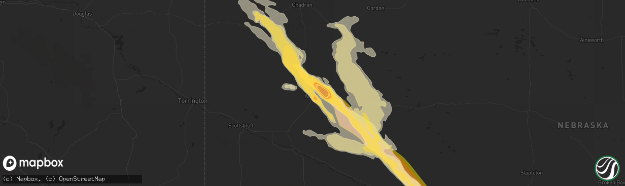
Hail
477
Estimated number of impacted properties by a 1.00" hail or larger393
Estimated number of impacted properties by a 1.75" hail or larger479
Estimated number of impacted properties by a 2.50" hail or largerStorm reports in Alliance, NE
Alliance, NE
| Date | Description |
|---|---|
| 06/25/20156:53 PM CDT | A local report indicates 1.00 inch wind near ALLIANCE |
| 06/25/20156:45 PM CDT | A local report indicates 1.75 inch wind near ALLIANCE |
| 06/25/20156:35 PM CDT | National weather service employee driving through the area encountered 65 mph winds and 1.25 inch diameter hail north of alliance |
| 06/25/20152:30 PM CDT | Duration 10 minutes. |
| 06/25/20152:30 PM CDT | Duration 30 minutes. |
| 06/25/20152:30 PM CDT | A local report indicates 80 MPH wind near 3 W ANTIOCH |
| 06/25/20152:26 PM CDT | Duration 34 minutes. |
| 06/25/20152:24 PM CDT | Duration 10 minutes. |
| 06/25/20152:20 PM CDT | Duration 10 minutes. |
| 06/25/20152:20 PM CDT | A local report indicates 1.75 inch wind near 7 NE ALLIANCE |
| 06/25/20152:20 PM CDT | Duration 5 minutes. |
| 06/25/20152:20 PM CDT | Duration 15 minutes. |
| 06/25/20152:20 PM CDT | Hail lasted from 120 to 127pm. 55mph wind gusts measured. Windows broken out of garage and basement. 0.31 inches of liquid measured. |
| 06/25/20152:20 PM CDT | Duration 5 minutes. |
| 06/25/20152:20 PM CDT | Duration 30 minutes. |
| 06/25/20152:18 PM CDT | A local report indicates 1.75 inch wind near 5 NNE ALLIANCE |
| 06/25/20152:18 PM CDT | A local report indicates 4.25 inch wind near 6 NE ALLIANCE |
| 06/25/20152:15 PM CDT | Duration 20 minutes. |
| 06/25/20152:10 PM CDT | Duration 20 minutes. |
| 06/25/20151:50 PM CDT | Duration 20 minutes. |
All States Impacted by Hail Map on June 25, 2015
All Cities Impacted by Hail Map on June 25, 2015
- Dawson, NE
- Stella, NE
- Humboldt, NE
- Table Rock, NE
- Verdon, NE
- Mankato, KS
- Formoso, KS
- Harrisburg, MO
- Columbia, MO
- Bennett, CO
- La Salle, CO
- Strasburg, CO
- Keenesburg, CO
- Hudson, CO
- McDowell, KY
- Grethel, KY
- San Jose, NM
- Harrisburg, NE
- Bayard, NE
- Yuma, CO
- Eckley, CO
- Wray, CO
- Bridgeport, NE
- Chapel Hill, NC
- Durham, NC
- Topeka, KS
- Gravois Mills, MO
- Edwards, MO
- Stover, MO
- Climax Springs, MO
- Edgemont, SD
- Hanover, KS
- Bremen, KS
- Buckner, MO
- Sibley, MO
- Independence, MO
- Beattie, KS
- Oketo, KS
- Liberty, NE
- Hettick, IL
- Palmyra, IL
- Greenfield, IL
- Oakley, KS
- Winona, KS
- Montezuma, KS
- New Baden, IL
- Albers, IL
- Okawville, IL
- Tyner, KY
- Manchester, KY
- Sizerock, KY
- Sextons Creek, KY
- Bear Branch, KY
- Oneida, KY
- Booneville, KY
- Kingston, GA
- Horton, KS
- Hiawatha, KS
- Everest, KS
- Holly, CO
- Sublette, KS
- Satanta, KS
- Wallace, KS
- Magnolia, KY
- Buffalo, KY
- Mount Sherman, KY
- Rockbridge, IL
- Waldo, KS
- Paradise, KS
- Sedley, VA
- Louisa, KY
- Hay Springs, NE
- Booker, TX
- Perryton, TX
- Balko, OK
- Venice, IL
- Madison, IL
- Granite City, IL
- East Saint Louis, IL
- Lusk, WY
- Manville, WY
- Ellsworth, NE
- Bonnie, IL
- Johnsonville, IL
- Opdyke, IL
- Kell, IL
- Ina, IL
- Mount Vernon, IL
- Bluford, IL
- Centralia, IL
- Texico, IL
- Belle Rive, IL
- Salem, IL
- Iuka, IL
- Keenes, IL
- Harrodsburg, KY
- Lancaster, KY
- Danville, KY
- Marienthal, KS
- Suffolk, VA
- Barnes, KS
- Waterville, KS
- Randolph, KS
- Garfield, KY
- Harned, KY
- Pendleton, NC
- Como, NC
- Cartersville, GA
- Lithia, FL
- Bowling Green, FL
- Mulberry, FL
- Courtland, VA
- Ivor, VA
- Wakefield, VA
- Carrsville, VA
- Waverly, VA
- Franklin, VA
- Clarksville, VA
- Delia, KS
- Junction City, KS
- Troy, IL
- O'Fallon, IL
- Lebanon, IL
- Collinsville, IL
- Robinson Creek, KY
- Pikeville, KY
- Deer Trail, CO
- Marshall, MO
- Slater, MO
- Sweet Springs, MO
- Great Bend, KS
- Rush Center, KS
- Hoisington, KS
- Pawnee Rock, KS
- Larned, KS
- Albert, KS
- Otis, KS
- Olmitz, KS
- Saint Joseph, MO
- Coulterville, IL
- Corydon, IN
- Cedartown, GA
- Rozel, KS
- Scottsville, VA
- Moseley, VA
- Midlothian, VA
- Powhatan, VA
- Ulmer, SC
- Nunn, CO
- Cheyenne, WY
- Ault, CO
- Shelbiana, KY
- Elkhorn City, KY
- Alliance, NE
- Carbondale, KS
- Falls Of Rough, KY
- Lillington, NC
- Broadway, NC
- Chula, MO
- Trenton, MO
- Turtle Lake, ND
- Mercer, ND
- Washburn, ND
- Wilton, ND
- New Cambria, MO
- Callao, MO
- Cary, NC
- Burlington, NC
- Carrboro, NC
- Mebane, NC
- Morrisville, NC
- Cedar Grove, NC
- Hillsborough, NC
- Apex, NC
- Efland, NC
- Farmersville, IL
- Girard, IL
- Keystone, SD
- Rapid City, SD
- Hermosa, SD
- St John, KS
- Greenville, IN
- Georgetown, IN
- Keaton, KY
- Flatgap, KY
- West Liberty, KY
- Bahama, NC
- Gatesville, NC
- Gates, NC
- Lakeland, FL
- Williamsburg, KS
- Pomona, KS
- Hardinsburg, KY
- Cannelton, IN
- Cloverport, KY
- Oak Grove, MO
- Bates City, MO
- Campbellsville, KY
- Lance Creek, WY
- Blue Springs, NE
- Wymore, NE
- Gypsum, KS
- Seibert, CO
- Howe, IN
- Shipshewana, IN
- Wolcottville, IN
- Lagrange, IN
- Auxvasse, MO
- Dillwyn, VA
- Buckingham, VA
- Beaver, OK
- Franktown, CO
- Columbia, NC
- Lagrange, WY
- Nashville, IL
- Edenton, NC
- Hertford, NC
- Colerain, NC
- Tyner, NC
- Trementina, NM
- Salyersville, KY
- Cimarron, KS
- Sheridan Lake, CO
- Lamar, CO
- Upton, WY
- Sidney, NE
- Cuba, AL
- Toomsuba, MS
- Santa Claus, IN
- Lamar, IN
- Walterboro, SC
- Ruffin, SC
- Blackburn, MO
- Henderson, NC
- Boydton, VA
- Hemingford, NE
- Chillicothe, MO
- Concordia, KS
- Emporia, VA
- Syracuse, KS
- Macon, NC
- Norlina, NC
- Warrenton, NC
- Prince George, VA
- Stafford, VA
- Leasburg, NC
- Roxboro, NC
- Mandan, ND
- Whitney, NE
- Burns, WY
- Esmont, VA
- Schuyler, VA
- Arvonia, VA
- Keene, VA
- Palmyra, VA
- Bremo Bluff, VA
- Howardsville, VA
- New Canton, VA
- Chadron, NE
- Copeland, KS
- Colorado Springs, CO
- Princeton, KY
- Fredonia, KY
- Gasburg, VA
- White Plains, VA
- Littleton, NC
- Henrico, NC
- Campbellsburg, IN
- Sonora, KY
- Glendale, KY
- Hodgenville, KY
- Elizabethtown, KY
- Hugoton, KS
- Liberal, KS
- Kiowa, CO
- Malta Bend, MO
- Taylorsville, KY
- Boise City, OK
- Myakka City, FL
- Bernalillo, NM
- Algodones, NM
- Parrish, FL
- Crawford, NE
- Glenvil, NE
- Glendo, WY
- Hartville, WY
- Jay Em, WY
- Thousandsticks, KY
- Hyden, KY
- Fayette, MS
- Kansas City, KS
- Kit Carson, CO
- Cheyenne Wells, CO
- Eugene, MO
- Gladstone, NM
- Carpenter, WY
- Hillsdale, WY
- Center, ND
- Piedmont, AL
- Eolia, MO
- Bowling Green, MO
- Church Road, VA
- Amelia Court House, VA
- Leoti, KS
- Moscow, KS
- Grafton, IL
- Bardstown, KY
- Beloit, KS
- Winfield, MO
- Old Monroe, MO
- Hobbsville, NC
- Belvidere, NC
- Morganville, KS
- Clyde, KS
- Saint Thomas, MO
- Westphalia, MO
- Meta, MO
- Jefferson City, MO
- Hasty, CO
- Jameson, MO
- Pattonsburg, MO
- Madrid, NE
- Soldier, KS
- Dodge City, KS
- Wright, KS
- Jetmore, KS
- Okeechobee, FL
- Cairo, MO
- Excello, MO
- Jacksonville, MO
- Moberly, MO
- Mineral, VA
- Louisa, VA
- New Middletown, IN
- Elizabeth, IN
- Semora, NC
- Lees Summit, MO
- Levasy, MO
- Liberty, MO
- Pleasant Hill, MO
- Orrick, MO
- Holden, MO
- Greenwood, MO
- Wellington, MO
- Grain Valley, MO
- Strasburg, MO
- Blue Springs, MO
- Centerview, MO
- Mayview, MO
- Lexington, MO
- Lone Jack, MO
- Kansas City, MO
- Odessa, MO
- Smithville, MO
- Kingsville, MO
- Napoleon, MO
- Centralia, MO
- Montgomery City, MO
- Wellsville, MO
- Hazen, ND
- Lemoyne, NE
- Keystone, NE
- Grenville, NM
- Rushville, MO
- Atchison, KS
- Weston, MO
- Elsberry, MO
- Foley, MO
- Moscow Mills, MO
- Hawk Point, MO
- Silex, MO
- Brussels, IL
- Troy, MO
- Golden Eagle, IL
- Batchtown, IL
- Vevay, IN
- Canaan, IN
- Madison, IN
- Springfield, CO
- Hazel Green, KY
- Campton, KY
- Bingham, NE
- Lakeside, NE
- Oshkosh, NE
- Paxton, NE
- Ogallala, NE
- Lisco, NE
- Marsland, NE
- Arthur, NE
- Lewellen, NE
- Newcastle, WY
- Windsor, VA
- Elizabeth, CO
- Parker, CO
- Madison, MO
- Lake Wales, FL
- Belleville, IL
- Chesterfield, VA
- Goochland, VA
- Waverly, MO
- Dover, MO
- Somerset, KY
- Turpin, OK
- Tyrone, OK
- Windsor, MO
- Bullock, NC
- Manson, NC
- Buffalo Junction, VA
- Skipwith, VA
- Plains, KS
- Tipton, MO
- Abilene, KS
- Chapman, KS
- Enterprise, KS
- Cope, CO
- Flagler, CO
- Olsburg, KS
- Gallion, AL
- Claflin, KS
- Easton, KS
- De Witt, NE
- Pickrell, NE
- Kampsville, IL
- Eldred, IL
- Carrollton, IL
- Saint Meinrad, IN
- Dale, IN
- Evanston, IN
- Ferdinand, IN
- Kingman, KS
- Cunningham, KS
- Rich Square, NC
- Jackson, NC
- Woodland, NC
- Pecos, TX
- Kings Mountain, KY
- Liberty, KY
- Yosemite, KY
- Middleburg, KY
- Goldvein, VA
- Midland, VA
- Catlett, VA
- Angora, NE
- Kermit, WV
- Lovely, KY
- Sutherlin, VA
- Milton, NC
- Keeling, VA
- Ringgold, VA
- Alton, VA
- Blairs, VA
- Richland, IN
- Chrisney, IN
- Rome, GA
- Gadsden, AL
- Covesville, VA
- Merriman, NE
- Broadwater, NE
- Rushville, NE
- Harrison, NE
- Ashby, NE
- Hyannis, NE
- Edgar, NE
- Ong, NE
- Wheatland, WY
- Centralia, KS
- Middletown, MO
- Stanford, KY
- Hustonville, KY
- Waynesburg, KY
- Minatare, NE
- Gering, NE
- Birdseye, IN
- Eckerty, IN
- Taswell, IN
- Dubois, IN
- Celestine, IN
- French Lick, IN
- Virgilina, VA
- Silver Lake, KS
- Holyrood, KS
- Bushton, KS
- Lanesville, IN
- Louisville, KY
- English, IN
- Leavenworth, IN
- Fairdale, KY
- Brooks, KY
- Depauw, IN
- West Point, KY
- Laconia, IN
- Shepherdsville, KY
- Wingina, VA
- Viola, KS
- Agenda, KS
- Trenton, ND
- Williston, ND
- Fort Knox, KY
- Radcliff, KY
- Lebanon Junction, KY
- Teaberry, KY
- Byers, CO
- Penhook, VA
- Chatham, VA
- Westmoreland, KS
- Bethelridge, KY
- Eubank, KY
- Briggsdale, CO
- Kersey, CO
- Hale, MO
- Jackson, KY
- Sunbury, NC
- Wilsondale, WV
- Dunlow, WV
- Crum, WV
- Fort Gay, WV
- Crothersville, IN
- Alma, IL
- Alberta, VA
- Union Hall, VA
- Glade Hill, VA
- Loveland, CO
- Windsor, CO
- Fort Collins, CO
- Corning, KS
- Parkers Lake, KY
- London, KY
- Warrensburg, MO
- Huntsville, MO
- Bonner Springs, KS
- Russell Springs, KY
- Calhoun, MO
- Colby, KS
- Brule, NE
- Milltown, IN
- Marengo, IN
- Max, ND
- Stapleton, NE
- Effingham, KS
- Muscotah, KS
- Leavenworth, KS
- New Salem, ND
- Cheney, KS
- Grandview, MO
- Hazard, KY
- Bonnyman, KY
- Greenville, KY
- Meade, KS
- Ensign, KS
- Willisburg, KY
- Plant City, FL
- Windsor, NC
- Willow Spring, NC
- Angier, NC
- Fuquay Varina, NC
- Kaycee, WY
- Chugwater, WY
- Wheeling, MO
- Laclede, MO
- Meadville, MO
- Russell, KS
- Minot, ND
- Bristow, IN
- Grayson, KY
- Hitchins, KY
- Olive Hill, KY
- Burnside, KY
- Bronston, KY
- Laredo, MO
- Beatrice, NE
- Fayette, MO
- Manhattan, KS
- Scottsburg, IN
- Springfield, KY
- Stockton, KS
- Ghent, KY
- Warsaw, KY
- Carrollton, KY
- Glenrock, WY
- Douglas, WY
- Overland Park, KS
- Tamaroa, IL
- Pinckneyville, IL
- Roggen, CO
- Crozier, VA
- Zuni, VA
- Clarksville, MO
- Pacific, MO
- Catawissa, MO
- Cedar Hill, MO
- Gallatin, MO
- Immokalee, FL
- Dry Fork, VA
- Sandy Level, VA
- Natoma, KS
- Rosendale, MO
- Savannah, MO
- Fork Union, VA
- Kents Store, VA
- Columbia, VA
- Fargo, GA
- Homerville, GA
- Halliday, ND
- Brookfield, MO
- Nancy, KY
- Smithfield, VA
- Elberon, VA
- Vona, CO
- Genoa, WV
- Esbon, KS
- Casper, WY
- Wright City, MO
- Foristell, MO
- Harper, KS
- Simpson, KS
- High Hill, MO
- New Florence, MO
- Montrose, MO
- Macon, MO
- Seneca, KS
- Thompson, MO
- Ulysses, KS
- Burkesville, KY
- Crab Orchard, KY
- Leopold, IN
- Tell City, IN
- Branchville, IN
- Jamesport, MO
- Rousseau, KY
- Agate, CO
- Vandalia, MO
- Perry, MO
- Cecilia, KY
- Creswell, NC
- Bucyrus, KS
- Macedonia, IL
- Ewing, IL
- McLeansboro, IL
- Castle Rock, CO
- Lowmansville, KY
- Harts, WV
- Breeden, WV
- Adams, NE
- Tecumseh, NE
- Limon, CO
- Science Hill, KY
- Corbin, KY
- White Hall, IL
- Eastview, KY
- Big Clifty, KY
- White Mills, KY
- Filley, NE
- Nebo, IL
- Chesapeake, VA
- Eutaw, AL
- Afton, VA
- Blue Rapids, KS
- Garysburg, NC
- Skippers, VA
- Gaston, NC
- Roanoke Rapids, NC
- Branchville, VA
- Murfreesboro, NC
- Pawnee City, NE
- Burchard, NE
- Eureka, MO
- Granada, CO
- Clay Center, KS
- Merritt Island, FL
- Patrick Afb, FL
- Cocoa, FL
- Peck, KS
- Clearwater, KS
- Mackville, KY
- Roper, NC
- Scott City, KS
- Blackstone, VA
- Axtell, KS
- Baileyville, KS
- Du Bois, NE
- Jamesville, NC
- Cummings, KS
- Lancaster, KS
- Columbia, KY
- Glens Fork, KY
- Fieldon, IL
- Edson, KS
- Hollenberg, KS
- Diller, NE
- Odell, NE
- Marysville, KS
- Holton, KS
- Benton City, MO
- Ekron, KY
- Muldraugh, KY
- Brandenburg, KY
- Vine Grove, KY
- Elnora, IN
- Newberry, IN
- Danville, VA
- Timberlake, NC
- Linden, NC
- Bunnlevel, NC
- Spring Lake, NC
- Appleton City, MO
- Rockville, MO
- Elk Horn, KY
- Oakdale, IL
- Mexico, MO
- Lincoln, MO
- Phelps, KY
- Steele, KY
- Phyllis, KY
- Kimper, KY
- La Monte, MO
- Houstonia, MO
- Chandler, IN
- Elberfeld, IN
- Bradenton, FL
- Scranton, KS
- Burlingame, KS
- Hooker, OK
- Smiths Grove, KY
- Monticello, KY
- Camden, MO
- Lackey, KY
- Prestonsburg, KY
- Eastern, KY
- Printer, KY
- Minnie, KY
- Drift, KY
- Virgie, KY
- Harold, KY
- Langley, KY
- Raccoon, KY
- Garrett, KY
- Hueysville, KY
- Howey In The Hills, FL
- Cartersville, VA
- Charlottesville, VA
- Cumberland, VA
- North Garden, VA
- Union Star, MO
- King City, MO
- Bolckow, MO
- Rea, MO
- Franklinton, NC
- Two Buttes, CO
- Grant, NE
- Denver, CO
- Greenleaf, KS
- Harrellsville, NC
- Cofield, NC
- Ahoskie, NC
- Winton, NC
- Sarasota, FL
- Ramah, CO
- Petersburg, VA
- Martinsburg, MO
- Laddonia, MO
- Stanton, ND
- Worthville, KY
- New Liberty, KY
- Turners Station, KY
- Sanders, KY
- Owenton, KY
- Halifax, NC
- Enfield, NC
- Scotland Neck, NC
- Snyder, CO
- Steamboat Springs, CO
- Knob Noster, MO
- Concordia, MO
- Shawnee, WY
- Santa Fe, MO
- Nelson, MO
- Alma, MO
- Disputanta, VA
- Fort Lee, VA
- Clayton, NM
- Lake Placid, FL
- Venus, FL
- Livingston, AL
- Demopolis, AL
- York, AL
- Camden, SC
- Ridgeway, SC
- Palestine, IL
- Merom, IN
- Hutsonville, IL
- Brodhead, KY
- Gilliam, MO
- Pekin, IN
- Borden, IN
- Greensburg, KY
- Farmville, VA
- Hartford, KY
- Tatum, NM
- Hillview, IL
- Pearl, IL
- Belton, KY
- Morgantown, KY
- Dunmor, KY
- Lewisburg, KY
- West Paducah, KY
- Paducah, KY
- Forgan, OK
- Seymour, IN
- Pleasant Hill, NC
- Eure, NC
- Virden, IL
- Wamego, KS
- Onaga, KS
- Louisburg, KS
- Buckhorn, KY
- Ricetown, KY
- Beattyville, KY
- Elizabeth City, NC
- Chester, VA
- State Farm, VA
- Richmond, VA
- Maidens, VA
- Hopewell, VA
- Sutherland, VA
- Faber, VA
- Colonial Heights, VA
- Surry, VA
- Corapeake, NC
- Spring Grove, VA
- Stony Creek, VA
- Yale, VA
- Carson, VA
- Dendron, VA
- Las Animas, CO
- Edwardsville, IL
- New Hope, KY
- Loretto, KY
- Saint Francis, KY
- Gravel Switch, KY
- Bradfordsville, KY
- Carr, CO
- Wellington, CO
- Clay Center, NE
- Moore Haven, FL
- Upton, KY
- Rineyville, KY
- Hughesville, MO
- Rock Port, MO
- Lewiston Woodville, NC
- Simla, CO
- Shawnee, KS
- Daytona Beach, FL
- Gaylord, KS
- Saint Louis, MO
- Osceola, MO
- Olathe, KS
- Stilwell, KS
- Belton, MO
- Leawood, KS
- Denton, KY
- Windsor, KY
- West Monroe, LA
- Grand Marais, MN
- Gunlock, KY
- Vest, KY
- Mize, KY
- Vancleve, KY
- Cannel City, KY
- Lost Creek, KY
- Clayhole, KY
- Chester, OK
- Turon, KS
- Sylvia, KS
- Plevna, KS
- Paola, KS
- Baskerville, VA
- Nelson, VA
- Garden City, KS
- Peyton, CO
- Orleans, IN
- Paoli, IN
- Hardinsburg, IN
- Coolidge, KS
- Hugo, CO
- California, MO
- Dawson Springs, KY
- Virginia Beach, VA
- Norfolk, VA
- Linneus, MO
- Mount Vernon, KY
- Paris, MO
- Pilot Grove, MO
- Conway, NC
- Astatula, FL
- Clermont, FL
- Hillrose, CO
- La Junta, CO
- Aliceville, AL
- Harveyville, KS
- Hoyt, KS
- Germantown, IL
- Crandall, IN
- New Salisbury, IN
- Eskridge, KS
- Auburn, KS
- Maple Hill, KS
- Wentzville, MO
- Du Quoin, IL
- Williamston, NC
- Cole Camp, MO
- Lowry City, MO
- Clermont, KY
- Spivey, KS
- Grady, NM
- Glasco, KS
- Champion, NE
- Imperial, NE
- Mascoutah, IL
- Fordsville, KY
- Custer, KY
- Hudson, KY
- Westview, KY
- Pantego, NC
- Pinetown, NC
- Plymouth, NC
- Birmingham, AL
- Falls City, NE
- Gower, MO
- Agency, MO
- Johnson, KS
- Whittington, IL
- Benton, IL
- Stafford, KS
- Salem, IN
- Jasper, IN
- Grantsburg, IN
- Erwin, NC
- Fayetteville, NC
- Sanford, NC
- Holly Springs, NC
- Raleigh, NC
- Dunn, NC
- Coats, NC
- Jenkins, KY
- Robinson, IL
- Alcova, WY
- Bloomfield, KY
- Bealeton, VA
- Fredericksburg, VA
- Ballwin, MO
- Chesterfield, MO
- Aurora, KS
- Summersville, KY
- Shoals, IN
- Olaton, KY
- Bulan, KY
- Ary, KY
- Rowdy, KY
- Waggoner, IL
- Sterling, NE
- Manor, GA
- Argyle, GA
- Newport News, VA
- Dundas, VA
- Ramsey, IN
- Creedmoor, NC
- Rociada, NM
- Ridgeland, SC
- Russellville, MO
- Drewryville, VA
- Boykins, VA
- Gordon, NE
- Norborne, MO
- Central City, KY
- Drakesboro, KY
- Brewster, KS
- Dwight, KS
- Grandview, IN
- Jamestown, KY
- Miami, MO
- Carrollton, MO
- Loose Creek, MO
- Almont, ND
- Sumner, MO
- Bucklin, MO
- Garrett, WY
- Clark, MO
- Higginsville, MO
- Boonville, IN
- Gentryville, IN
- Tennyson, IN
- Zephyrhills, FL
- Bismarck, ND
- Columbia, IL
- Lawrenceville, VA
- Freeman, VA
- Dolphin, VA
- Seaboard, NC
- Margarettsville, NC
- Wiley, CO
- Ingalls, KS
- Mendon, MO
- Rothville, MO
- Summerfield, KS
- Clifton, KS
- Tipton, KS
- McClave, CO
- O'Fallon, MO
- Bellflower, MO
- Truxton, MO
- Warrenton, MO
- Jonesburg, MO
- Annada, MO
- Hamburg, IL
- Alma, KS
- Eros, LA
- Paint Lick, KY
- Henley, MO
- Olean, MO
- New Haven, KY
- Boston, KY
- Mortons Gap, KY
- Madisonville, KY
- Sedalia, MO
- Garden Plain, KS
- Haysville, KS
- Murdock, KS
- Goddard, KS
- Sedalia, CO
- Littleton, CO
- Saint Jacob, IL
- Marine, IL
- Palmer, IL
- Owaneco, IL
- Morrisonville, IL
- Taylorville, IL
- Assumption, IL
- Blythewood, SC
- Clarksburg, MO
- Wagon Mound, NM
- White Plains, KY
- McKenney, VA
- Dewitt, VA
- Ford, VA
- Wilsons, VA
- Caneyville, KY
- Horse Branch, KY
- Jarratt, VA
- Bypro, KY
- Topmost, KY
- Dema, KY
- Hi Hat, KY
- Bevinsville, KY
- Wheelwright, KY
- Rocky Mount, VA
- Florissant, MO
- Saint Charles, MO
- West Alton, MO
- Otterville, MO
- Fortuna, MO
- Florence, MO
- Bunceton, MO
- Syracuse, MO
- New England, ND
- Elbert, CO
- Beaver Dam, KY
- Rochester, KY
- De Kalb, MS
- Powhattan, KS
- Webbville, KY
- Ward, AL
- Belvue, KS
- Cosby, MO
- Dahlgren, IL
- Brodnax, VA
- Bunnell, FL
- Willow Hill, IL
- Stephensport, KY
- Union Star, KY
- Belleville, KS
- Boons Camp, KY
- Tomahawk, KY
- Gordo, AL
- Battletown, KY
- Payneville, KY
- Belhaven, NC
- Hanover, IN
- Lexington, IN
- Eads, CO
- Potter, NE
- Fairbury, NE
- Oblong, IL
- Manakin Sabot, VA
- Rockville, VA
- Leeton, MO
- Fort Meade, FL
- Coxs Creek, KY
- Gurley, NE
- Hawesville, KY
- Troy, IN
- Lewisport, KY
- Pine Bluffs, WY
- Albin, WY
- Frankfort, KS
- Brooklet, GA
- Grundy, VA
- Hurley, VA
- Maryville, IL
- Caseyville, IL
- Hazelwood, MO
- Lovejoy, IL
- East Carondelet, IL
- Dupo, IL
- Millstadt, IL
- Fairview Heights, IL
- New Smyrna Beach, FL
- Inez, KY
- Ulysses, KY
- Warfield, KY
- Lenore, WV
- Beauty, KY
- Pilgrim, KY
- Las Vegas, NM
- Walnut Hill, IL
- Dix, IL
- Freeburg, MO
- Henrico, VA
- Wauneta, NE
- Elsie, NE
- Mauckport, IN
- Oxford, NC
- Amazonia, MO
- Holliday, MO
- Latham, MO
- Haven, KS
- Dundee, KY
- Bern, KS
- Rome, IN
- Derby, IN
- Rhodelia, KY
- Henderson, KY
- Evansville, IN
- Green, KS
- Herington, KS
- Saint Catharine, KY
- Wakarusa, KS
- Elk Creek, NE
- Trinchera, CO
- Portage Des Sioux, MO
- Alta Vista, KS
- Mulkeytown, IL
- Deland, FL
- Gretna, VA
- Platteville, CO
- Johnstown, CO
- Burlington, ND


