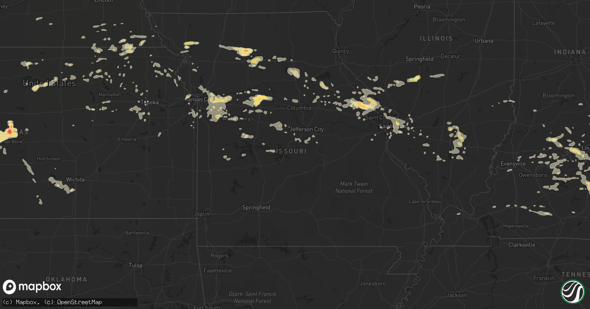
Hail Map in Missouri on June 25, 2015
Get this storm
June 25 map
$229
one time, instant access
Download today. No call, no setup
Keep the $229
Bought the map and want the full workflow? Apply the entire $229 to a subscription within 7 days. None of it is wasted.
Every map, not just this one
This buys you this map. Subscription and you get every map we run, in the markets you choose from a few cities to whole states to nationwide. Plus real-time alerts the moment a storm fires.
Contact data
Name, contact info, occupancy, even credit band for addresses in the footprint. You go from where it hit to who to call.
Become the source they trust
Unlimited branding weather history reports on demand. You already have the documented answer ready for the property owner, and you are the one who showed up with it.
Property data and RoofTrace estimates
Pull up any address you have got, its value and the exact code rules for that jurisdiction, straight from One Click Code. Then RoofTrace estimates the squares, pitch, and roof value, priced the way you price.
Storm reports in Missouri
Missouri
| Date | Description |
|---|---|
| 06/25/20156:58 PM CDT | A local report indicates 1.75 inch wind near TROY |
| 06/25/20156:56 PM CDT | A local report indicates 1.25 inch wind near MARSHALL |
| 06/25/20156:51 PM CDT | A local report indicates 1.75 inch wind near MARSHALL |
| 06/25/20156:50 PM CDT | A local report indicates 1.00 inch wind near MARSHALL |
| 06/25/20156:47 PM CDT | Received via social media |
| 06/25/20156:45 PM CDT | A local report indicates 1.00 inch wind near MARSHALL |
| 06/25/20156:36 PM CDT | Report came in via social media. |
| 06/25/20156:30 PM CDT | Power lines and tree limbs down from strong winds. |
| 06/25/20156:27 PM CDT | Large tree blown down on hwy 24 |
| 06/25/20156:25 PM CDT | Tree limbs down |
| 06/25/20156:19 PM CDT | A local report indicates 1.25 inch wind near SUMNER |
| 06/25/20156:10 PM CDT | Several tree limbs broken in the wind. Lasted for several minutes |
| 06/25/20156:10 PM CDT | Broken tree limb... 12 inches in diameter. |
| 06/25/20155:58 PM CDT | Tree limbs down... 18 inches in diameter. |
| 06/25/20155:55 PM CDT | Numerous 6 to 10 inch tree limbs laying across hwy 36 near meadville. |
| 06/25/20155:30 PM CDT | A local report indicates 1.75 inch wind near CHULA |
| 06/25/20155:28 PM CDT | A local report indicates 1.00 inch wind near 2 W CHULA |
| 06/25/20154:17 AM CDT | A large tree was blown over blocking a road and two fire work tents collapse in the city of laurie. |
| 06/25/20154:00 AM CDT | Tree blown down highway 7 - time estimated. Reported by volunteer weather observer ben402. |
| 06/25/20153:52 AM CDT | 2 trees over highway 254. Road closed. |
| 06/25/20153:46 AM CDT | Large trees down near north street and n spur. |
| 06/25/20153:40 AM CDT | Several reports of trees down in city limits. Around 0340 am a report of a tree down near polk street and hillcrest lane. |
| 06/25/20153:38 AM CDT | A local report indicates 70 MPH wind near OSCEOLA |
| 06/25/20153:27 AM CDT | Tree limb 10 inches in diameter down on power line at 2nd and missouri ave.... Which caused power line to break. Portion of limb went through roof of outbuilding. |
| 06/25/20153:22 AM CDT | Power line down at 3rd st. And cherry st. |
| 06/25/20152:30 AM CDT | 8 inch tree broken along with others. Damaged roof and fence observed. |
| 06/25/20152:20 AM CDT | Large tree down 2 miles south of independence |
| 06/25/20152:12 AM CDT | A local report indicates 65 MPH wind near PLEASANT HILL |
| 06/25/20152:10 AM CDT | Broken tree limb 6 inches in diameter. |
| 06/25/20152:09 AM CDT | Large portion of tree snapped off... Blocking road. Pic via facebook. |
| 06/25/20152:08 AM CDT | Uprooted tree in blue springs... Partially destroying a deck on a house. Pics via twitter. |
| 06/25/20152:04 AM CDT | Numerous large branches down... Including half of a tree split due to wind |
| 06/25/20152:02 AM CDT | 60 mph winds |
| 06/25/20151:56 AM CDT | Lxt measured 53 knots |
| 06/25/20151:51 AM CDT | Tree limb snapped... 20 inches in diameter. |
| 06/25/20151:51 AM CDT | A local report indicates 75 MPH wind near 1 SE KANSAS CITY |
| 06/25/20151:51 AM CDT | Large tree branches and limbs down near 39th st and phelps rd in independence. Pics via twitter. |
| 06/25/20151:50 AM CDT | Estimaed 70 to 80 mph with trees down. Unknow how big the trees are. |
| 06/25/20151:50 AM CDT | Large tree 4 feet in diameter down along with multiple power lines. |
| 06/25/20151:49 AM CDT | A local report indicates 80 MPH wind near RIVERSIDE |
| 06/25/20151:49 AM CDT | Roof damage to a building. Picture via facebook. |
| 06/25/20151:48 AM CDT | Large tree branches and limbs down in raytown near 47th st and sterling ave. Pics via twitter. |
| 06/25/20151:45 AM CDT | Large tree blown over and blocking s delaware ave |
| 06/25/20151:42 AM CDT | Mkc measured 51 knots |
| 06/25/20151:40 AM CDT | Large pin oak tree blown down |
| 06/25/20151:38 AM CDT | 12 inch tree snapped on city hall property |
| 06/25/20151:35 AM CDT | Numerous trees blocking roads just southwest of avondale |
| 06/25/20151:30 AM CDT | 16 inch trees reportedly uprooted |
| 06/25/20151:30 AM CDT | 12 to 15 inch diameter limbs down at n anita dr and n northwood rd. |
| 06/24/201510:13 PM CDT | A couple trees were downed near laurie. |
| 06/24/20159:24 PM CDT | A local report indicates 60 MPH wind near CHESTERFIELD |
| 06/24/20158:40 PM CDT | Roof blown off a mobile home and trees and power lines down |
| 06/24/20158:22 PM CDT | Multiple limbs down. Some six inches in diameter. |
| 06/24/20158:15 PM CDT | Off highway a in wellsville. Overturned two car carport...1 fence panel thrown 10ft into pool...another fence panel torn through patio screen room...screen room ceiling |
| 06/24/20158:15 PM CDT | Trees down |
| 06/24/20158:15 PM CDT | Trees and limbs down |
| 06/24/20158:10 PM CDT | Trees and limbs down |
| 06/24/20158:05 PM CDT | Tree snapped and fell ontu a home. Time estimated from radar. |
| 06/24/20157:55 PM CDT | Strong winds overturned several railroad cars which are blocking intersections on county road 509 and also on locust street |
| 06/24/20157:55 PM CDT | Large tree down on jefferson road |
| 06/24/20157:55 PM CDT | Large tree down |
| 06/24/20157:35 PM CDT | 55 kts measured in marshall |
| 06/24/20157:32 PM CDT | Trees and limbs down in paris and just south of paris |
| 06/24/20157:22 PM CDT | Large branches down |
| 06/24/20157:20 PM CDT | Trees blown across hwy z and hwy dd. Parts of moberly are currently without power. Clifton hill is also without power. |
| 06/24/20157:20 PM CDT | Several trees damaged and down along hwy 24 between moberly and route yy. |
| 06/24/20157:15 PM CDT | A local report indicates 1.00 inch wind near 5 W MADISON |
| 06/24/20157:15 PM CDT | A local report indicates 1.50 inch wind near 1 SW MARSHALL |
| 06/24/20157:15 PM CDT | A local report indicates 60 MPH wind near 1 SW MARSHALL |
| 06/24/20157:15 PM CDT | A local report indicates 1.00 inch wind near MARSHALL |
| 06/24/20157:12 PM CDT | 61 kts measured at moberly |
| 06/24/20157:10 PM CDT | Isolated tree damage. Limb of 6 inches snapped. Via social media |
| 06/24/20157:07 PM CDT | Shed blown away and tree limbs down...a 35 to 40 foot tall tree was blown down from the winds |
| 06/24/20157:05 PM CDT | A local report indicates 1.00 inch wind near MARSHALL |
All States Impacted by Hail Map on June 25, 2015
Cities Impacted by Hail Map on June 25, 2015
- Dawson, NE
- Stella, NE
- Humboldt, NE
- Table Rock, NE
- Verdon, NE
- Mankato, KS
- Formoso, KS
- Harrisburg, MO
- Columbia, MO
- Bennett, CO
- La Salle, CO
- Strasburg, CO
- Keenesburg, CO
- Hudson, CO
- McDowell, KY
- Grethel, KY
- San Jose, NM
- Harrisburg, NE
- Bayard, NE
- Yuma, CO
- Eckley, CO
- Wray, CO
- Bridgeport, NE
- Chapel Hill, NC
- Durham, NC
- Topeka, KS
- Gravois Mills, MO
- Edwards, MO
- Stover, MO
- Climax Springs, MO
- Edgemont, SD
- Hanover, KS
- Bremen, KS
- Buckner, MO
- Sibley, MO
- Independence, MO
- Beattie, KS
- Oketo, KS
- Liberty, NE
- Hettick, IL
- Palmyra, IL
- Greenfield, IL
- Oakley, KS
- Winona, KS
- Montezuma, KS
- New Baden, IL
- Albers, IL
- Okawville, IL
- Tyner, KY
- Manchester, KY
- Sizerock, KY
- Sextons Creek, KY
- Bear Branch, KY
- Oneida, KY
- Booneville, KY
- Kingston, GA
- Horton, KS
- Hiawatha, KS
- Everest, KS
- Holly, CO
- Sublette, KS
- Satanta, KS
- Wallace, KS
- Magnolia, KY
- Buffalo, KY
- Mount Sherman, KY
- Rockbridge, IL
- Waldo, KS
- Paradise, KS
- Sedley, VA
- Louisa, KY
- Hay Springs, NE
- Booker, TX
- Perryton, TX
- Balko, OK
- Venice, IL
- Madison, IL
- Granite City, IL
- East Saint Louis, IL
- Lusk, WY
- Manville, WY
- Ellsworth, NE
- Bonnie, IL
- Johnsonville, IL
- Opdyke, IL
- Kell, IL
- Ina, IL
- Mount Vernon, IL
- Bluford, IL
- Centralia, IL
- Texico, IL
- Belle Rive, IL
- Salem, IL
- Iuka, IL
- Keenes, IL
- Harrodsburg, KY
- Lancaster, KY
- Danville, KY
- Marienthal, KS
- Suffolk, VA
- Barnes, KS
- Waterville, KS
- Randolph, KS
- Garfield, KY
- Harned, KY
- Pendleton, NC
- Como, NC
- Cartersville, GA
- Lithia, FL
- Bowling Green, FL
- Mulberry, FL
- Courtland, VA
- Ivor, VA
- Wakefield, VA
- Carrsville, VA
- Waverly, VA
- Franklin, VA
- Clarksville, VA
- Delia, KS
- Junction City, KS
- Troy, IL
- O'Fallon, IL
- Lebanon, IL
- Collinsville, IL
- Robinson Creek, KY
- Pikeville, KY
- Deer Trail, CO
- Marshall, MO
- Slater, MO
- Sweet Springs, MO
- Great Bend, KS
- Rush Center, KS
- Hoisington, KS
- Pawnee Rock, KS
- Larned, KS
- Albert, KS
- Otis, KS
- Olmitz, KS
- Saint Joseph, MO
- Coulterville, IL
- Corydon, IN
- Cedartown, GA
- Rozel, KS
- Scottsville, VA
- Moseley, VA
- Midlothian, VA
- Powhatan, VA
- Ulmer, SC
- Nunn, CO
- Cheyenne, WY
- Ault, CO
- Shelbiana, KY
- Elkhorn City, KY
- Alliance, NE
- Carbondale, KS
- Falls Of Rough, KY
- Lillington, NC
- Broadway, NC
- Chula, MO
- Trenton, MO
- Turtle Lake, ND
- Mercer, ND
- Washburn, ND
- Wilton, ND
- New Cambria, MO
- Callao, MO
- Cary, NC
- Burlington, NC
- Carrboro, NC
- Mebane, NC
- Morrisville, NC
- Cedar Grove, NC
- Hillsborough, NC
- Apex, NC
- Efland, NC
- Farmersville, IL
- Girard, IL
- Keystone, SD
- Rapid City, SD
- Hermosa, SD
- St John, KS
- Greenville, IN
- Georgetown, IN
- Keaton, KY
- Flatgap, KY
- West Liberty, KY
- Bahama, NC
- Gatesville, NC
- Gates, NC
- Lakeland, FL
- Williamsburg, KS
- Pomona, KS
- Hardinsburg, KY
- Cannelton, IN
- Cloverport, KY
- Oak Grove, MO
- Bates City, MO
- Campbellsville, KY
- Lance Creek, WY
- Blue Springs, NE
- Wymore, NE
- Gypsum, KS
- Seibert, CO
- Howe, IN
- Shipshewana, IN
- Wolcottville, IN
- Lagrange, IN
- Auxvasse, MO
- Dillwyn, VA
- Buckingham, VA
- Beaver, OK
- Franktown, CO
- Columbia, NC
- Lagrange, WY
- Nashville, IL
- Edenton, NC
- Hertford, NC
- Colerain, NC
- Tyner, NC
- Trementina, NM
- Salyersville, KY
- Cimarron, KS
- Sheridan Lake, CO
- Lamar, CO
- Upton, WY
- Sidney, NE
- Cuba, AL
- Toomsuba, MS
- Santa Claus, IN
- Lamar, IN
- Walterboro, SC
- Ruffin, SC
- Blackburn, MO
- Henderson, NC
- Boydton, VA
- Hemingford, NE
- Chillicothe, MO
- Concordia, KS
- Emporia, VA
- Syracuse, KS
- Macon, NC
- Norlina, NC
- Warrenton, NC
- Prince George, VA
- Stafford, VA
- Leasburg, NC
- Roxboro, NC
- Mandan, ND
- Whitney, NE
- Burns, WY
- Esmont, VA
- Schuyler, VA
- Arvonia, VA
- Keene, VA
- Palmyra, VA
- Bremo Bluff, VA
- Howardsville, VA
- New Canton, VA
- Chadron, NE
- Copeland, KS
- Colorado Springs, CO
- Princeton, KY
- Fredonia, KY
- Gasburg, VA
- White Plains, VA
- Littleton, NC
- Henrico, NC
- Campbellsburg, IN
- Sonora, KY
- Glendale, KY
- Hodgenville, KY
- Elizabethtown, KY
- Hugoton, KS
- Liberal, KS
- Kiowa, CO
- Malta Bend, MO
- Taylorsville, KY
- Boise City, OK
- Myakka City, FL
- Bernalillo, NM
- Algodones, NM
- Parrish, FL
- Crawford, NE
- Glenvil, NE
- Glendo, WY
- Hartville, WY
- Jay Em, WY
- Thousandsticks, KY
- Hyden, KY
- Fayette, MS
- Kansas City, KS
- Kit Carson, CO
- Cheyenne Wells, CO
- Eugene, MO
- Gladstone, NM
- Carpenter, WY
- Hillsdale, WY
- Center, ND
- Piedmont, AL
- Eolia, MO
- Bowling Green, MO
- Church Road, VA
- Amelia Court House, VA
- Leoti, KS
- Moscow, KS
- Grafton, IL
- Bardstown, KY
- Beloit, KS
- Winfield, MO
- Old Monroe, MO
- Hobbsville, NC
- Belvidere, NC
- Morganville, KS
- Clyde, KS
- Saint Thomas, MO
- Westphalia, MO
- Meta, MO
- Jefferson City, MO
- Hasty, CO
- Jameson, MO
- Pattonsburg, MO
- Madrid, NE
- Soldier, KS
- Dodge City, KS
- Wright, KS
- Jetmore, KS
- Okeechobee, FL
- Cairo, MO
- Excello, MO
- Jacksonville, MO
- Moberly, MO
- Mineral, VA
- Louisa, VA
- New Middletown, IN
- Elizabeth, IN
- Semora, NC
- Lees Summit, MO
- Levasy, MO
- Liberty, MO
- Pleasant Hill, MO
- Orrick, MO
- Holden, MO
- Greenwood, MO
- Wellington, MO
- Grain Valley, MO
- Strasburg, MO
- Blue Springs, MO
- Centerview, MO
- Mayview, MO
- Lexington, MO
- Lone Jack, MO
- Kansas City, MO
- Odessa, MO
- Smithville, MO
- Kingsville, MO
- Napoleon, MO
- Centralia, MO
- Montgomery City, MO
- Wellsville, MO
- Hazen, ND
- Lemoyne, NE
- Keystone, NE
- Grenville, NM
- Rushville, MO
- Atchison, KS
- Weston, MO
- Elsberry, MO
- Foley, MO
- Moscow Mills, MO
- Hawk Point, MO
- Silex, MO
- Brussels, IL
- Troy, MO
- Golden Eagle, IL
- Batchtown, IL
- Vevay, IN
- Canaan, IN
- Madison, IN
- Springfield, CO
- Hazel Green, KY
- Campton, KY
- Bingham, NE
- Lakeside, NE
- Oshkosh, NE
- Paxton, NE
- Ogallala, NE
- Lisco, NE
- Marsland, NE
- Arthur, NE
- Lewellen, NE
- Newcastle, WY
- Windsor, VA
- Elizabeth, CO
- Parker, CO
- Madison, MO
- Lake Wales, FL
- Belleville, IL
- Chesterfield, VA
- Goochland, VA
- Waverly, MO
- Dover, MO
- Somerset, KY
- Turpin, OK
- Tyrone, OK
- Windsor, MO
- Bullock, NC
- Manson, NC
- Buffalo Junction, VA
- Skipwith, VA
- Plains, KS
- Tipton, MO
- Abilene, KS
- Chapman, KS
- Enterprise, KS
- Cope, CO
- Flagler, CO
- Olsburg, KS
- Gallion, AL
- Claflin, KS
- Easton, KS
- De Witt, NE
- Pickrell, NE
- Kampsville, IL
- Eldred, IL
- Carrollton, IL
- Saint Meinrad, IN
- Dale, IN
- Evanston, IN
- Ferdinand, IN
- Kingman, KS
- Cunningham, KS
- Rich Square, NC
- Jackson, NC
- Woodland, NC
- Pecos, TX
- Kings Mountain, KY
- Liberty, KY
- Yosemite, KY
- Middleburg, KY
- Goldvein, VA
- Midland, VA
- Catlett, VA
- Angora, NE
- Kermit, WV
- Lovely, KY
- Sutherlin, VA
- Milton, NC
- Keeling, VA
- Ringgold, VA
- Alton, VA
- Blairs, VA
- Richland, IN
- Chrisney, IN
- Rome, GA
- Gadsden, AL
- Covesville, VA
- Merriman, NE
- Broadwater, NE
- Rushville, NE
- Harrison, NE
- Ashby, NE
- Hyannis, NE
- Edgar, NE
- Ong, NE
- Wheatland, WY
- Centralia, KS
- Middletown, MO
- Stanford, KY
- Hustonville, KY
- Waynesburg, KY
- Minatare, NE
- Gering, NE
- Birdseye, IN
- Eckerty, IN
- Taswell, IN
- Dubois, IN
- Celestine, IN
- French Lick, IN
- Virgilina, VA
- Silver Lake, KS
- Holyrood, KS
- Bushton, KS
- Lanesville, IN
- Louisville, KY
- English, IN
- Leavenworth, IN
- Fairdale, KY
- Brooks, KY
- Depauw, IN
- West Point, KY
- Laconia, IN
- Shepherdsville, KY
- Wingina, VA
- Viola, KS
- Agenda, KS
- Trenton, ND
- Williston, ND
- Fort Knox, KY
- Radcliff, KY
- Lebanon Junction, KY
- Teaberry, KY
- Byers, CO
- Penhook, VA
- Chatham, VA
- Westmoreland, KS
- Bethelridge, KY
- Eubank, KY
- Briggsdale, CO
- Kersey, CO
- Hale, MO
- Jackson, KY
- Sunbury, NC
- Wilsondale, WV
- Dunlow, WV
- Crum, WV
- Fort Gay, WV
- Crothersville, IN
- Alma, IL
- Alberta, VA
- Union Hall, VA
- Glade Hill, VA
- Loveland, CO
- Windsor, CO
- Fort Collins, CO
- Corning, KS
- Parkers Lake, KY
- London, KY
- Warrensburg, MO
- Huntsville, MO
- Bonner Springs, KS
- Russell Springs, KY
- Calhoun, MO
- Colby, KS
- Brule, NE
- Milltown, IN
- Marengo, IN
- Max, ND
- Stapleton, NE
- Effingham, KS
- Muscotah, KS
- Leavenworth, KS
- New Salem, ND
- Cheney, KS
- Grandview, MO
- Hazard, KY
- Bonnyman, KY
- Greenville, KY
- Meade, KS
- Ensign, KS
- Willisburg, KY
- Plant City, FL
- Windsor, NC
- Willow Spring, NC
- Angier, NC
- Fuquay Varina, NC
- Kaycee, WY
- Chugwater, WY
- Wheeling, MO
- Laclede, MO
- Meadville, MO
- Russell, KS
- Minot, ND
- Bristow, IN
- Grayson, KY
- Hitchins, KY
- Olive Hill, KY
- Burnside, KY
- Bronston, KY
- Laredo, MO
- Beatrice, NE
- Fayette, MO
- Manhattan, KS
- Scottsburg, IN
- Springfield, KY
- Stockton, KS
- Ghent, KY
- Warsaw, KY
- Carrollton, KY
- Glenrock, WY
- Douglas, WY
- Overland Park, KS
- Tamaroa, IL
- Pinckneyville, IL
- Roggen, CO
- Crozier, VA
- Zuni, VA
- Clarksville, MO
- Pacific, MO
- Catawissa, MO
- Cedar Hill, MO
- Gallatin, MO
- Immokalee, FL
- Dry Fork, VA
- Sandy Level, VA
- Natoma, KS
- Rosendale, MO
- Savannah, MO
- Fork Union, VA
- Kents Store, VA
- Columbia, VA
- Fargo, GA
- Homerville, GA
- Halliday, ND
- Brookfield, MO
- Nancy, KY
- Smithfield, VA
- Elberon, VA
- Vona, CO
- Genoa, WV
- Esbon, KS
- Casper, WY
- Wright City, MO
- Foristell, MO
- Harper, KS
- Simpson, KS
- High Hill, MO
- New Florence, MO
- Montrose, MO
- Macon, MO
- Seneca, KS
- Thompson, MO
- Ulysses, KS
- Burkesville, KY
- Crab Orchard, KY
- Leopold, IN
- Tell City, IN
- Branchville, IN
- Jamesport, MO
- Rousseau, KY
- Agate, CO
- Vandalia, MO
- Perry, MO
- Cecilia, KY
- Creswell, NC
- Bucyrus, KS
- Macedonia, IL
- Ewing, IL
- McLeansboro, IL
- Castle Rock, CO
- Lowmansville, KY
- Harts, WV
- Breeden, WV
- Adams, NE
- Tecumseh, NE
- Limon, CO
- Science Hill, KY
- Corbin, KY
- White Hall, IL
- Eastview, KY
- Big Clifty, KY
- White Mills, KY
- Filley, NE
- Nebo, IL
- Chesapeake, VA
- Eutaw, AL
- Afton, VA
- Blue Rapids, KS
- Garysburg, NC
- Skippers, VA
- Gaston, NC
- Roanoke Rapids, NC
- Branchville, VA
- Murfreesboro, NC
- Pawnee City, NE
- Burchard, NE
- Eureka, MO
- Granada, CO
- Clay Center, KS
- Merritt Island, FL
- Patrick Afb, FL
- Cocoa, FL
- Peck, KS
- Clearwater, KS
- Mackville, KY
- Roper, NC
- Scott City, KS
- Blackstone, VA
- Axtell, KS
- Baileyville, KS
- Du Bois, NE
- Jamesville, NC
- Cummings, KS
- Lancaster, KS
- Columbia, KY
- Glens Fork, KY
- Fieldon, IL
- Edson, KS
- Hollenberg, KS
- Diller, NE
- Odell, NE
- Marysville, KS
- Holton, KS
- Benton City, MO
- Ekron, KY
- Muldraugh, KY
- Brandenburg, KY
- Vine Grove, KY
- Elnora, IN
- Newberry, IN
- Danville, VA
- Timberlake, NC
- Linden, NC
- Bunnlevel, NC
- Spring Lake, NC
- Appleton City, MO
- Rockville, MO
- Elk Horn, KY
- Oakdale, IL
- Mexico, MO
- Lincoln, MO
- Phelps, KY
- Steele, KY
- Phyllis, KY
- Kimper, KY
- La Monte, MO
- Houstonia, MO
- Chandler, IN
- Elberfeld, IN
- Bradenton, FL
- Scranton, KS
- Burlingame, KS
- Hooker, OK
- Smiths Grove, KY
- Monticello, KY
- Camden, MO
- Lackey, KY
- Prestonsburg, KY
- Eastern, KY
- Printer, KY
- Minnie, KY
- Drift, KY
- Virgie, KY
- Harold, KY
- Langley, KY
- Raccoon, KY
- Garrett, KY
- Hueysville, KY
- Howey In The Hills, FL
- Cartersville, VA
- Charlottesville, VA
- Cumberland, VA
- North Garden, VA
- Union Star, MO
- King City, MO
- Bolckow, MO
- Rea, MO
- Franklinton, NC
- Two Buttes, CO
- Grant, NE
- Denver, CO
- Greenleaf, KS
- Harrellsville, NC
- Cofield, NC
- Ahoskie, NC
- Winton, NC
- Sarasota, FL
- Ramah, CO
- Petersburg, VA
- Martinsburg, MO
- Laddonia, MO
- Stanton, ND
- Worthville, KY
- New Liberty, KY
- Turners Station, KY
- Sanders, KY
- Owenton, KY
- Halifax, NC
- Enfield, NC
- Scotland Neck, NC
- Snyder, CO
- Steamboat Springs, CO
- Knob Noster, MO
- Concordia, MO
- Shawnee, WY
- Santa Fe, MO
- Nelson, MO
- Alma, MO
- Disputanta, VA
- Fort Lee, VA
- Clayton, NM
- Lake Placid, FL
- Venus, FL
- Livingston, AL
- Demopolis, AL
- York, AL
- Camden, SC
- Ridgeway, SC
- Palestine, IL
- Merom, IN
- Hutsonville, IL
- Brodhead, KY
- Gilliam, MO
- Pekin, IN
- Borden, IN
- Greensburg, KY
- Farmville, VA
- Hartford, KY
- Tatum, NM
- Hillview, IL
- Pearl, IL
- Belton, KY
- Morgantown, KY
- Dunmor, KY
- Lewisburg, KY
- West Paducah, KY
- Paducah, KY
- Forgan, OK
- Seymour, IN
- Pleasant Hill, NC
- Eure, NC
- Virden, IL
- Wamego, KS
- Onaga, KS
- Louisburg, KS
- Buckhorn, KY
- Ricetown, KY
- Beattyville, KY
- Elizabeth City, NC
- Chester, VA
- State Farm, VA
- Richmond, VA
- Maidens, VA
- Hopewell, VA
- Sutherland, VA
- Faber, VA
- Colonial Heights, VA
- Surry, VA
- Corapeake, NC
- Spring Grove, VA
- Stony Creek, VA
- Yale, VA
- Carson, VA
- Dendron, VA
- Las Animas, CO
- Edwardsville, IL
- New Hope, KY
- Loretto, KY
- Saint Francis, KY
- Gravel Switch, KY
- Bradfordsville, KY
- Carr, CO
- Wellington, CO
- Clay Center, NE
- Moore Haven, FL
- Upton, KY
- Rineyville, KY
- Hughesville, MO
- Rock Port, MO
- Lewiston Woodville, NC
- Simla, CO
- Shawnee, KS
- Daytona Beach, FL
- Gaylord, KS
- Saint Louis, MO
- Osceola, MO
- Olathe, KS
- Stilwell, KS
- Belton, MO
- Leawood, KS
- Denton, KY
- Windsor, KY
- West Monroe, LA
- Grand Marais, MN
- Gunlock, KY
- Vest, KY
- Mize, KY
- Vancleve, KY
- Cannel City, KY
- Lost Creek, KY
- Clayhole, KY
- Chester, OK
- Turon, KS
- Sylvia, KS
- Plevna, KS
- Paola, KS
- Baskerville, VA
- Nelson, VA
- Garden City, KS
- Peyton, CO
- Orleans, IN
- Paoli, IN
- Hardinsburg, IN
- Coolidge, KS
- Hugo, CO
- California, MO
- Dawson Springs, KY
- Virginia Beach, VA
- Norfolk, VA
- Linneus, MO
- Mount Vernon, KY
- Paris, MO
- Pilot Grove, MO
- Conway, NC
- Astatula, FL
- Clermont, FL
- Hillrose, CO
- La Junta, CO
- Aliceville, AL
- Harveyville, KS
- Hoyt, KS
- Germantown, IL
- Crandall, IN
- New Salisbury, IN
- Eskridge, KS
- Auburn, KS
- Maple Hill, KS
- Wentzville, MO
- Du Quoin, IL
- Williamston, NC
- Cole Camp, MO
- Lowry City, MO
- Clermont, KY
- Spivey, KS
- Grady, NM
- Glasco, KS
- Champion, NE
- Imperial, NE
- Mascoutah, IL
- Fordsville, KY
- Custer, KY
- Hudson, KY
- Westview, KY
- Pantego, NC
- Pinetown, NC
- Plymouth, NC
- Birmingham, AL
- Falls City, NE
- Gower, MO
- Agency, MO
- Johnson, KS
- Whittington, IL
- Benton, IL
- Stafford, KS
- Salem, IN
- Jasper, IN
- Grantsburg, IN
- Erwin, NC
- Fayetteville, NC
- Sanford, NC
- Holly Springs, NC
- Raleigh, NC
- Dunn, NC
- Coats, NC
- Jenkins, KY
- Robinson, IL
- Alcova, WY
- Bloomfield, KY
- Bealeton, VA
- Fredericksburg, VA
- Ballwin, MO
- Chesterfield, MO
- Aurora, KS
- Summersville, KY
- Shoals, IN
- Olaton, KY
- Bulan, KY
- Ary, KY
- Rowdy, KY
- Waggoner, IL
- Sterling, NE
- Manor, GA
- Argyle, GA
- Newport News, VA
- Dundas, VA
- Ramsey, IN
- Creedmoor, NC
- Rociada, NM
- Ridgeland, SC
- Russellville, MO
- Drewryville, VA
- Boykins, VA
- Gordon, NE
- Norborne, MO
- Central City, KY
- Drakesboro, KY
- Brewster, KS
- Dwight, KS
- Grandview, IN
- Jamestown, KY
- Miami, MO
- Carrollton, MO
- Loose Creek, MO
- Almont, ND
- Sumner, MO
- Bucklin, MO
- Garrett, WY
- Clark, MO
- Higginsville, MO
- Boonville, IN
- Gentryville, IN
- Tennyson, IN
- Zephyrhills, FL
- Bismarck, ND
- Columbia, IL
- Lawrenceville, VA
- Freeman, VA
- Dolphin, VA
- Seaboard, NC
- Margarettsville, NC
- Wiley, CO
- Ingalls, KS
- Mendon, MO
- Rothville, MO
- Summerfield, KS
- Clifton, KS
- Tipton, KS
- McClave, CO
- O'Fallon, MO
- Bellflower, MO
- Truxton, MO
- Warrenton, MO
- Jonesburg, MO
- Annada, MO
- Hamburg, IL
- Alma, KS
- Eros, LA
- Paint Lick, KY
- Henley, MO
- Olean, MO
- New Haven, KY
- Boston, KY
- Mortons Gap, KY
- Madisonville, KY
- Sedalia, MO
- Garden Plain, KS
- Haysville, KS
- Murdock, KS
- Goddard, KS
- Sedalia, CO
- Littleton, CO
- Saint Jacob, IL
- Marine, IL
- Palmer, IL
- Owaneco, IL
- Morrisonville, IL
- Taylorville, IL
- Assumption, IL
- Blythewood, SC
- Clarksburg, MO
- Wagon Mound, NM
- White Plains, KY
- McKenney, VA
- Dewitt, VA
- Ford, VA
- Wilsons, VA
- Caneyville, KY
- Horse Branch, KY
- Jarratt, VA
- Bypro, KY
- Topmost, KY
- Dema, KY
- Hi Hat, KY
- Bevinsville, KY
- Wheelwright, KY
- Rocky Mount, VA
- Florissant, MO
- Saint Charles, MO
- West Alton, MO
- Otterville, MO
- Fortuna, MO
- Florence, MO
- Bunceton, MO
- Syracuse, MO
- New England, ND
- Elbert, CO
- Beaver Dam, KY
- Rochester, KY
- De Kalb, MS
- Powhattan, KS
- Webbville, KY
- Ward, AL
- Belvue, KS
- Cosby, MO
- Dahlgren, IL
- Brodnax, VA
- Bunnell, FL
- Willow Hill, IL
- Stephensport, KY
- Union Star, KY
- Belleville, KS
- Boons Camp, KY
- Tomahawk, KY
- Gordo, AL
- Battletown, KY
- Payneville, KY
- Belhaven, NC
- Hanover, IN
- Lexington, IN
- Eads, CO
- Potter, NE
- Fairbury, NE
- Oblong, IL
- Manakin Sabot, VA
- Rockville, VA
- Leeton, MO
- Fort Meade, FL
- Coxs Creek, KY
- Gurley, NE
- Hawesville, KY
- Troy, IN
- Lewisport, KY
- Pine Bluffs, WY
- Albin, WY
- Frankfort, KS
- Brooklet, GA
- Grundy, VA
- Hurley, VA
- Maryville, IL
- Caseyville, IL
- Hazelwood, MO
- Lovejoy, IL
- East Carondelet, IL
- Dupo, IL
- Millstadt, IL
- Fairview Heights, IL
- New Smyrna Beach, FL
- Inez, KY
- Ulysses, KY
- Warfield, KY
- Lenore, WV
- Beauty, KY
- Pilgrim, KY
- Las Vegas, NM
- Walnut Hill, IL
- Dix, IL
- Freeburg, MO
- Henrico, VA
- Wauneta, NE
- Elsie, NE
- Mauckport, IN
- Oxford, NC
- Amazonia, MO
- Holliday, MO
- Latham, MO
- Haven, KS
- Dundee, KY
- Bern, KS
- Rome, IN
- Derby, IN
- Rhodelia, KY
- Henderson, KY
- Evansville, IN
- Green, KS
- Herington, KS
- Saint Catharine, KY
- Wakarusa, KS
- Elk Creek, NE
- Trinchera, CO
- Portage Des Sioux, MO
- Alta Vista, KS
- Mulkeytown, IL
- Deland, FL
- Gretna, VA
- Platteville, CO
- Johnstown, CO
- Burlington, ND


