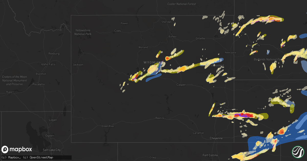
Hail Map in Wyoming on June 23, 2023
Get this storm
June 23 map
$229
one time, instant access
Download today. No call, no setup
Keep the $229
Bought the map and want the full workflow? Apply the entire $229 to a subscription within 7 days. None of it is wasted.
Every map, not just this one
This buys you this map. Subscription and you get every map we run, in the markets you choose from a few cities to whole states to nationwide. Plus real-time alerts the moment a storm fires.
Contact data
Name, contact info, occupancy, even credit band for addresses in the footprint. You go from where it hit to who to call.
Become the source they trust
Unlimited branding weather history reports on demand. You already have the documented answer ready for the property owner, and you are the one who showed up with it.
Property data and RoofTrace estimates
Pull up any address you have got, its value and the exact code rules for that jurisdiction, straight from One Click Code. Then RoofTrace estimates the squares, pitch, and roof value, priced the way you price.
Storm reports in Wyoming
Wyoming
| Date | Description |
|---|---|
| 06/23/20236:46 PM CDT | Additional reports of ongoing cycling tornado east of chugwater. |
| 06/23/20236:32 PM CDT | Multiple reports of tornado touchdown ene of chugwater. |
| 06/23/20236:22 PM CDT | A local report indicates 2.25 inch wind near 8 NE Chugwater |
| 06/23/20236:15 PM CDT | Report from mping: ping pong ball |
| 06/23/20236:14 PM CDT | A local report indicates a tornado near 4 ENE Chugwater |
| 06/23/20236:04 PM CDT | A local report indicates 1.75 inch wind near 4 NE Chugwater |
| 06/23/20235:54 PM CDT | Recieved via social media. |
| 06/23/20235:33 PM CDT | Public reported tornado near converse/campbell county line at 4:33 pm... Has since lifted. Photo recieved via social media. |
| 06/23/20235:30 PM CDT | Report from mping: golf ball |
| 06/23/20235:25 PM CDT | Report from mping: quarter |
| 06/23/20235:18 PM CDT | Report from mping: hen egg |
| 06/23/20235:17 PM CDT | A local report indicates 1.50 inch wind near 2 NNW Wheatland |
| 06/23/20235:12 PM CDT | A local report indicates 1.75 inch wind near 8 NNW Chugwater |
| 06/23/20234:30 PM CDT | Delayed report. Damage to a residence between mile marker 21 and 22 on wy hwy 259. Hail estimated at 2.5 inch dimeter based on picture. Horse trailer flipped... Fuel ta |
| 06/23/20234:30 PM CDT | Multiple reports and videos of tornado south and southwest of midwest. |
| 06/23/20234:15 PM CDT | Delayed report. Social media picture showing large cone tornado on the ground looking southwest from edgerton. Estimated location based on radar rotation... Time of pic |
| 06/23/20233:40 PM CDT | Brief tornado on the ground reported by rancher to sheriffs office3. |
| 06/23/20233:38 PM CDT | Delayed report. Social media with picture of thin rope tornado touching down in distance north of natrona wy. Exact location estimated based on radar rotation and pictu |
| 06/23/20233:37 PM CDT | A local report indicates 1.00 inch wind near Kaycee |
| 06/23/20233:33 PM CDT | Delayed report. Rancher reported quarter sized hail and swirling clouds. No tornado or touchdown best they knew. |
| 06/23/20233:15 PM CDT | Public report relayed to em. |
| 06/23/20232:35 PM CDT | A local report indicates a tornado near 9 NE Granger |
| 06/23/20231:45 PM CDT | A local report indicates 2.00 inch wind near 2 N Lysite |
| 06/23/20231:05 PM CDT | A local report indicates 2.00 inch wind near 1 NE Riverton |
| 06/23/20231:05 PM CDT | A local report indicates 1.75 inch wind near 1 NNE Riverton |
| 06/23/20231:05 PM CDT | A local report indicates 1.25 inch wind near 1 WSW Riverton |
| 06/23/20231:05 PM CDT | A local report indicates 1.75 inch wind near 1 W Riverton |
| 06/23/20231:05 PM CDT | A local report indicates 1.25 inch wind near 2 W Riverton |
| 06/23/20231:02 PM CDT | A local report indicates 1.00 inch wind near 6 WNW Riverton |
| 06/23/20231:02 PM CDT | A local report indicates 1.00 inch wind near 4 W Riverton |
| 06/23/202312:20 PM CDT | Delayed report. Slightly larger than quarter-sized hail. Gusty winds damaged a gutter slightly. |
| 06/22/20238:35 PM CDT | A local report indicates 1.75 inch wind near 7 ENE Rochelle |
| 06/22/20238:19 PM CDT | A local report indicates a tornado near 5 E Rochelle |
| 06/22/20238:18 PM CDT | A local report indicates 1.75 inch wind near 8 S Fort Laramie |
| 06/22/20237:44 PM CDT | A local report indicates 60 MPH wind near 7 SW Aladdin |
| 06/22/20237:40 PM CDT | A local report indicates 2.75 inch wind near 4 SE Hawk Springs |
| 06/22/20237:40 PM CDT | A local report indicates 83 MPH wind near 25 ESE Wright |
| 06/22/20237:32 PM CDT | Numerous reports of large... Damaging... And rain wrapped torando located east of hawk springs moving east. |
| 06/22/20237:24 PM CDT | Recieved via social media. |
| 06/22/20237:06 PM CDT | Spotters report large tornado on the ground west of hawk springs. |
| 06/22/20237:02 PM CDT | Tornado struck north antelope mine. |
All States Impacted by Hail Map on June 23, 2023
Cities Impacted by Hail Map on June 23, 2023
- Perry, FL
- Mayo, FL
- Day, FL
- Daphne, AL
- Channing, TX
- Masterson, TX
- Dumas, TX
- Amarillo, TX
- Fritch, TX
- Panhandle, TX
- Borger, TX
- Canadian, TX
- Briscoe, TX
- Reydon, OK
- Wheeler, TX
- Mobeetie, TX
- Sweetwater, OK
- Hammon, OK
- Butler, OK
- Cheyenne, OK
- Custer City, OK
- Clinton, OK
- Cordell, OK
- Elk City, OK
- Dill City, OK
- Sentinel, OK
- Sayre, OK
- Canute, OK
- Foss, OK
- Arapaho, OK
- Electra, TX
- Iowa Park, TX
- Bessie, OK
- Thomas, OK
- Corn, OK
- Weatherford, OK
- Gotebo, OK
- Rocky, OK
- Hobart, OK
- Holliday, TX
- Hydro, OK
- Colony, OK
- Carnegie, OK
- Mountain View, OK
- Fort Cobb, OK
- Gracemont, OK
- Lookeba, OK
- Binger, OK
- Anadarko, OK
- Hinton, OK
- Geary, OK
- Calumet, OK
- Watonga, OK
- Greenfield, OK
- Okarche, OK
- Kingfisher, OK
- Omega, OK
- Minco, OK
- El Reno, OK
- Union City, OK
- Pocasset, OK
- Chickasha, OK
- Oklahoma City, OK
- Yukon, OK
- Piedmont, OK
- Edmond, OK
- Mustang, OK
- Tuttle, OK
- Bethany, OK
- Newcastle, OK
- Wheatland, OK
- Gordon, NE
- Sharon, OK
- Fargo, OK
- Arnett, OK
- Apache, OK
- Lander, WY
- Mutual, OK
- Woodward, OK
- Gage, OK
- Shattuck, OK
- Wichita Falls, TX
- Skellytown, TX
- Justin, TX
- Argyle, TX
- Frederick, OK
- Davidson, OK
- Loveland, OK
- Elgin, OK
- Pampa, TX
- Grandfield, OK
- Burkburnett, TX
- Chester, OK
- Cody, NE
- Cut Off, LA
- Carter, OK
- Crowell, TX
- Loving, TX
- Olney, TX
- Merriman, NE
- Vernon, TX
- Miami, TX
- Valentine, NE
- Lockport, LA
- Jermyn, TX
- Seymour, TX
- Decatur, TX
- Scotland, TX
- Archer City, TX
- Windthorst, TX
- Fletcher, OK
- Mooreland, OK
- Cyril, OK
- Flower Mound, TX
- Shamrock, TX
- Laverne, OK
- Shoshoni, WY
- Riverton, WY
- Lysite, WY
- Jeffrey City, WY
- Arapahoe, WY
- Seminole, OK
- Bowlegs, OK
- Maud, OK
- Wewoka, OK
- Earlsboro, OK
- Konawa, OK
- Sasakwa, OK
- Holdenville, OK
- Stonewall, OK
- Ada, OK
- Allen, OK
- Asher, OK
- Stratford, OK
- Byars, OK
- Wanette, OK
- Ten Sleep, WY
- Tupelo, OK
- Atwood, OK
- Wetumka, OK
- Calvin, OK
- Okemah, OK
- Casper, WY
- Hiland, WY
- Centrahoma, OK
- Coalgate, OK
- Stuart, OK
- Lamar, OK
- Dustin, OK
- Arminto, WY
- Kaycee, WY
- Gainesville, TX
- Whitesboro, TX
- Sadler, TX
- Canton, TX
- Snow, OK
- Stigler, OK
- Whitefield, OK
- Las Animas, CO
- Collinsville, TX
- Gunter, TX
- Howe, TX
- Tioga, TX
- Sherman, TX
- Midwest, WY
- Pilot Point, TX
- Celina, TX
- Van Alstyne, TX
- Anna, TX
- Immokalee, FL
- Spearfish, SD
- Lead, SD
- Mckinney, TX
- Melissa, TX
- Hasty, CO
- Friona, TX
- Dimmitt, TX
- Hereford, TX
- Midkiff, TX
- Harrold, SD
- Onida, SD
- Saint Onge, SD
- Sauk Centre, MN
- Glenrock, WY
- Broadus, MT
- Otter, MT
- Muleshoe, TX
- Douglas, WY
- Wheatland, WY
- Tripp, SD
- Kim, CO
- Lamar, CO
- Littlefield, TX
- Fieldton, TX
- Amherst, TX
- Levelland, TX
- Ropesville, TX
- Lubbock, TX
- Olivet, SD
- Niobrara, NE
- Center, NE
- Canyon, TX
- Verdigre, NE
- Holly, CO
- Granada, CO
- Hart, TX
- Belle Fourche, SD
- Nisland, SD
- Pritchett, CO
- Hale Center, TX
- Olton, TX
- Wolfforth, TX
- Smyer, TX
- Bloomfield, NE
- Gail, TX
- Shallowater, TX
- Yoder, WY
- Stratton, CO
- Vona, CO
- Loraine, TX
- Colorado City, TX
- Westbrook, TX
- Newell, SD
- Plainview, TX
- Springlake, TX
- Ree Heights, SD
- Miller, SD
- Campo, CO
- Kress, TX
- Wausa, NE
- Crofton, NE
- Hartington, NE
- Sudan, TX
- Earth, TX
- Slaton, TX
- Gillette, WY
- Groom, TX
- Roscoe, TX
- Ransom Canyon, TX
- Bethune, CO
- Mertzon, TX
- San Angelo, TX
- Burlington, CO
- Kirk, CO
- Idalia, CO
- Danbury, WI
- Hulett, WY
- Roberts, ID
- Brimson, MN
- Lame Deer, MT
- Clovis, NM
- Fairfield, MT
- Idaho Falls, ID
- Iron Belt, WI
- White Sulphur Springs, MT
- Fort Shaw, MT
- Vaughn, MT
- Buffalo, WY
- Alzada, MT
- Jacksonville, TX
- Bullard, TX
- Clearmont, WY
- Talihina, OK
- Dryden, TX
- Lafitte, LA
- Belle Chasse, LA
- Tyler, TX
- Frostproof, FL
- Athens, TX
- Wagner, SD
- North Bend, NE
- Ozona, TX
- Big Lake, TX
- Murchison, TX
- Ben Wheeler, TX
- Henderson, TX
- Clayton, OK
- Sheridan, WY
- Kenansville, FL
- Duncan, OK
- Marlow, OK
- Farmersville, TX
- Dodge, NE
- Tussy, OK
- Elmore City, OK
- Lenorah, TX
- Knott, TX
- Eustace, TX
- Blackshear, GA
- Garden City, TX
- Edgerton, WY
- Fort Worth, TX
- Burleson, TX
- Mansfield, TX
- River Ranch, FL
- Lake Wales, FL
- Finley, OK
- Daisy, OK
- Antlers, OK
- Pittsburg, OK
- Stringtown, OK
- Rattan, OK
- Robert Lee, TX
- Burneyville, OK
- Sylvania, GA
- Weston, WY
- North Branch, MN
- Jacksboro, TX
- Palestine, TX
- Rusk, TX
- Thackerville, OK
- Marietta, OK
- Sterling City, TX
- Alto, TX
- Hennepin, OK
- Overbrook, OK
- Ardmore, OK
- Prosper, TX
- Princeton, TX
- Gordonville, TX
- Long Branch, TX
- Garrison, TX
- Melbourne, FL
- Floyd, NM
- Portales, NM
- Elida, NM
- Stacy, MN
- Kinta, OK
- Ratliff City, OK
- Farwell, TX
- Madill, OK
- Wills Point, TX
- Terrell, TX
- Cumby, TX
- Watson, OK
- Saint Cloud, FL
- Avon, SD
- Dante, SD
- Flint, TX
- Midlothian, TX
- Alvarado, TX
- Arlington, TX
- Kennedale, TX
- Venus, TX
- Freeport, MN
- Melrose, MN
- Choteau, MT
- Mcalester, OK
- Kiowa, OK
- Wardville, OK
- Homerville, GA
- Brownsboro, TX
- Mount Enterprise, TX
- Timpson, TX
- Punta Gorda, FL
- Graham, OK
- Springer, OK
- Montalba, TX
- Lynch, NE
- Bristow, NE
- Broadview, MT
- Simms, MT
- Cascade, MT
- Coleridge, NE
- Lorenzo, TX
- Vernon, CO
- Wray, CO
- Christoval, TX
- Houston, TX
- Galena Park, TX
- Sweetwater, TX
- Kissimmee, FL
- Wilson, TX
- Post, TX
- Hawk Springs, WY
- Torrington, WY
- Dequincy, LA
- Singer, LA
- Lyman, NE
- Mitchell, NE
- Morrill, NE
- Mud Butte, SD
- Newcastle, WY
- Shawnee, WY
- Syracuse, KS
- Wall, TX
- Vancourt, TX
- Eola, TX
- Miles, TX
- Paint Rock, TX
- Mereta, TX
- Eldorado, TX
- Aladdin, WY
- Union Center, SD
- Sulphur, LA
- Lake Charles, LA
- Westlake, LA
- Haigler, NE
- Goodland, KS
- Briggsdale, CO
- Millersview, TX
- Eden, TX
- Menard, TX
- Kendall, KS
- Rule, TX
- Idalou, TX
- Old Glory, TX
- Haskell, TX
- Dickens, TX
- Petersburg, TX
- Crosbyton, TX
- Ralls, TX
- Spur, TX
- Abernathy, TX
- Sturgis, SD
- Boise City, OK
- New Underwood, SD
- Keyes, OK
- Elkhart, KS
- Goodwell, OK
- Walsh, CO
- Scottsbluff, NE
- Manderson, SD
- Gering, NE
- Porcupine, SD
- Pine Ridge, SD
- Kyle, SD
- Rapid City, SD
- Hermosa, SD
- Keystone, SD
- Long Valley, SD
- White River, SD
- Murdo, SD
- Johnson, KS
- Cypress, TX
- Box Elder, SD
- Holyoke, CO
- Haxtun, CO
- Ovid, CO
- Minatare, NE
- Philip, SD
- Quinn, SD
- Milesville, SD
- Midland, SD
- Ulysses, KS
- Scenic, SD
- Caputa, SD
- Rolla, KS
- Belvidere, SD
- Draper, SD
- New Raymer, CO
- Bayard, NE
- Angora, NE
- Orchard, CO
- Weldona, CO
- Ellsworth, NE
- Rushville, NE
- Fort Morgan, CO
- Faith, SD
- Julesburg, CO
- Melvin, TX
- Justiceburg, TX
- Big Springs, NE
- Chappell, NE
- Aspermont, TX
- Jayton, TX
- Snyder, TX
- Girard, TX
- Oshkosh, NE
- Lodgepole, NE
- Wanblee, SD
- Guymon, OK
- Hugoton, KS
- Interior, SD
- Presho, SD
- Kennebec, SD
- Lewellen, NE
- Hempstead, TX
- Waller, TX
- Oakdale, NE
- Neligh, NE
- Tilden, NE
- Snyder, CO
- Stoneham, CO
- Merino, CO
- Bingham, NE
- Ashby, NE
- Kadoka, SD
- Satanta, KS
- Meadow Grove, NE
- Ewing, NE
- Inman, NE
- Page, NE
- Garden City, KS
- Hooker, OK
- Orchard, NE
- Plainview, NE
- Bridgeport, NE
- Dodge City, KS
- Wright, KS
- Dupree, SD
- Whitman, NE
- Okaton, SD
- Dix, NE
- Sidney, NE
- Potter, NE
- Peetz, CO
- Padroni, CO
- Sterling, CO
- Iliff, CO
- Crook, CO
- Sedgwick, CO
- Fleming, CO
- Hyannis, NE
- Atwood, CO
- Lakeside, NE
- Lemoyne, NE
- Brule, NE
- Venango, NE
- Ogallala, NE
- Arthur, NE
- Keystone, NE
- Fort Laramie, WY
- Paxton, NE
- Sutherland, NE
- Tryon, NE
- Hayes, SD
- Fort Pierre, SD
- Royal, NE
- Springview, NE
- Paducah, TX
- Hershey, NE
- North Platte, NE
- Knox City, TX
- Crookston, NE
- Munday, TX
- Goree, TX
- Benjamin, TX
- Brady, TX
- Lohn, TX
- Vivian, SD
- Stapleton, NE
- Seneca, NE
- Mullen, NE
- Thedford, NE
- Chandler, TX
- Foley, MN
- Orting, WA
- Carlsbad, TX
- Eatonville, WA
- Labelle, FL
- Sundance, WY
- Orlando, FL
- Hermleigh, TX
- Center, TX
- Big Spring, TX
- Oneill, NE
- Katy, TX
- Burke, SD
- Venus, FL
- Moore Haven, FL
- Piedmont, SD
- Devils Tower, WY
- Beulah, WY
- Kaufman, TX
- Lusk, WY
- Lance Creek, WY
- Platte, SD
- Big Sandy, TX
- Royse City, TX
- Winner, SD
- Wayne, NE
- Wakefield, NE
- Hay Springs, NE
- Coahoma, TX
- Larue, TX
- Tennessee Colony, TX
- Edgewood, TX
- Childress, TX
- Deer Park, TX
- Tenaha, TX
- Shelbyville, TX
- San Augustine, TX
- Whitehouse, TX
- Rockledge, FL
- Iowa, LA
- Ragley, LA
- Kinder, LA
- Chugwater, WY
- Altamonte Springs, FL
- Maitland, FL
- Casselberry, FL
- Humble, TX
- Rocky Ford, GA
- Bassett, NE
- Vidor, TX
- Buna, TX
- Deweyville, TX
- Starks, LA
- Guernsey, WY
- Jay Em, WY
- Hockley, TX
- Maryneal, TX
- Chillicothe, TX
- Quanah, TX
- Bellaire, TX
- Pasadena, TX
- South Houston, TX
- Randolph, NE
- Springfield, SD
- McCamey, TX
- Kilgore, TX
- Gladewater, TX
- Whitewood, SD
- Reeves, LA
- Troup, TX
- Ideal, SD
- Anton, TX
- Ackerly, TX
- Laurel, NE
- Nazareth, TX
- Overton, TX
- Clearwater, NE
- Long Pine, NE
- Pierson, FL
- Lavon, TX
- Nevada, TX
- Happy, TX
- Decker, MT
- Kerens, TX
- Lake Mary, FL
- Longwood, FL
- Rice, TX
- Lehigh Acres, FL
- Cocoa Beach, FL
- Iraan, TX
- Astor, FL
- Veteran, WY
- Brashear, TX
- Lamesa, TX
- Tulia, TX
- Apopka, FL
- Highlands, TX
- Maxwell, NE
- Brady, NE
- Arnold, NE
- Norris, SD
- Parmelee, SD
- Sparks, NE
- Mission, SD
- Colome, SD
- Dutton, MT
- Terreton, ID
- Dunning, NE
- Anselmo, NE
- Halsey, NE
- Purdum, NE
- Brewster, NE
- Lower Brule, SD
- Dallas, SD
- Gregory, SD
- Mills, NE
- Saint Francis, SD
- Rosebud, SD
- Eagle Butte, SD
- Ridgeview, SD
- Agar, SD
- Gettysburg, SD
- Pierre, SD
- Blunt, SD
- Hamill, SD
- Chamberlain, SD
- Oacoma, SD
- Pukwana, SD
- Reliance, SD
- Fort Thompson, SD
- Gann Valley, SD
- Herrick, SD
- Stuart, NE
- Naper, NE
- Newport, NE
- Broken Bow, NE
- Sargent, NE
- Burwell, NE
- Taylor, NE
- Ainsworth, NE
- Lebanon, SD
- Saint Charles, SD
- Bonesteel, SD
- Atkinson, NE
- Butte, NE
- Kimball, SD
- White Lake, SD
- Woonsocket, SD
- Wessington Springs, SD
- Wessington, SD
- Holabird, SD
- Stephan, SD
- Highmore, SD
- Alpena, SD
- Saint Lawrence, SD
- Wolsey, SD
- Virgil, SD
- Huron, SD
- Hitchcock, SD
- Redfield, SD
- Tulare, SD
- Ord, NE
- Elyria, NE
- Rockham, SD
- Orient, SD
- Doland, SD
- Ashton, SD
- Frankfort, SD
- Scotia, NE
- Spalding, NE
- Greeley, NE
- Ericson, NE
- Albion, NE
- Elgin, NE
- Petersburg, NE
- Bartlett, NE
- Emmet, NE
- Amelia, NE
- Chambers, NE
- Saint Helena, NE
- Yankton, SD
- Winnetoon, NE
- Tabor, SD
- Tyndall, SD
- Lesterville, SD
- Utica, SD
- Mission Hill, SD
- Vermillion, SD
- Volin, SD
- Centerville, SD
- Beresford, SD
- Irene, SD
- Wakonda, SD
- Menno, SD
- Viborg, SD
- Lennox, SD
- Marion, SD
- Parker, SD
- Hurley, SD
- Davis, SD
- Freeman, SD
- Fordyce, NE
- Gayville, SD
- Alcester, SD
- Hawarden, IA
- Wynot, NE
- Elk Point, SD
- Burbank, SD
- Hudson, SD
- Canton, SD
- Chancellor, SD
- Sioux Falls, SD
- Hartford, SD
- Worthing, SD
- Tea, SD
- Harrisburg, SD
- Scotland, SD
- Rock Valley, IA
- Fairview, SD
- Inwood, IA
- Larchwood, IA
- Brandon, SD
- Renner, SD
- Valley Springs, SD
- Garretson, SD
- Dell Rapids, SD
- Baltic, SD
- Crooks, SD
- Spencer, NE
- Farwell, NE
- Saint Paul, NE
- Kimball, NE
- Richland Springs, TX
- Comstock, NE
- Palmer, NE
- Fullerton, NE
- Rochelle, TX
- Goldthwaite, TX
- Mullin, TX
- San Saba, TX
- Lagrange, WY
- Harrisburg, NE
- Rockville, NE
- Cimarron, KS
- Gatesville, TX
- Brookesmith, TX
- Brownwood, TX
- Ingalls, KS
- Pierceville, KS
- Lakin, KS
- Central City, NE
- Lost Springs, WY
- Brunswick, NE
- Creighton, NE
- Alliance, NE
- Mcadoo, TX
- Early, TX
- Ashton, NE
- Clarks, NE
- Holcomb, KS
- Fairfax, SD
- Zephyr, TX
- Hamilton, TX
- Pickstown, SD
- Lake Andes, SD
- Broadwater, NE
- Kilgore, NE
- Dalton, NE
- Gurley, NE
- Lampasas, TX
- Prairie View, TX
- Trent, SD
- Flandreau, SD
- Luverne, MN
- Jasper, MN
- Pipestone, MN
- Holland, MN
- Ruthton, MN
- Balaton, MN
- Ivanhoe, MN
- Elkton, SD
- Russell, MN
- Lake Benton, MN
- Arco, MN
- Tyler, MN
- Marshall, MN
- Lynd, MN
- Ghent, MN
- Minneota, MN
- Taunton, MN
- Edgerton, MN
- Woodstock, MN
- Deadwood, SD
- Genoa, NE
- Blair, NE
- Lawton, IA
- Hinton, IA
- Le Mars, IA
- Merrill, IA
- Sioux City, IA
- Kenneth, MN
- Boelus, NE
- Silver Creek, NE
- Kennard, NE
- Modale, IA
- Arlington, NE
- Missouri Valley, IA
- Herman, NE
- Nickerson, NE
- Litchfield, NE
- Ravenna, NE
- Loup City, NE
- Granville, IA
- Alton, IA
- Wood, SD
- Delmont, SD
- Monroe, NE
- Columbus, NE
- Clarkson, NE
- Madison, SD
- Ramona, SD
- Lismore, MN
- Marcus, IA
- Chandler, MN
- Remsen, IA
- Wolbach, NE
- Belgrade, NE
- Duncan, NE
- Lake Preston, SD
- Erwin, SD
- Holstein, IA
- Battle Creek, IA
- Sioux Rapids, IA
- Alta, IA
- Galva, IA
- Schaller, IA
- Cleghorn, IA
- Laurens, IA
- Albert City, IA
- Linn Grove, IA


