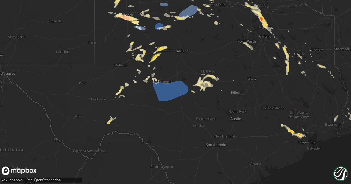
Hail Map in Texas on June 23, 2023
Get this storm
June 23 map
$229
one time, instant access
Download today. No call, no setup
Keep the $229
Bought the map and want the full workflow? Apply the entire $229 to a subscription within 7 days. None of it is wasted.
Every map, not just this one
This buys you this map. Subscription and you get every map we run, in the markets you choose from a few cities to whole states to nationwide. Plus real-time alerts the moment a storm fires.
Contact data
Name, contact info, occupancy, even credit band for addresses in the footprint. You go from where it hit to who to call.
Become the source they trust
Unlimited branding weather history reports on demand. You already have the documented answer ready for the property owner, and you are the one who showed up with it.
Property data and RoofTrace estimates
Pull up any address you have got, its value and the exact code rules for that jurisdiction, straight from One Click Code. Then RoofTrace estimates the squares, pitch, and roof value, priced the way you price.
Storm reports in Texas
Texas
| Date | Description |
|---|---|
| 06/23/20236:58 PM CDT | A local report indicates 62 MPH wind near 1 NNW Sherwood |
| 06/23/20236:51 PM CDT | A local report indicates 60 MPH wind near 6 W Arden |
| 06/23/20236:49 PM CDT | Fm 1585 and highway 87 |
| 06/23/20236:49 PM CDT | A local report indicates 4.00 inch wind near 1 N Woodrow |
| 06/23/20236:42 PM CDT | Time estimated by radar. |
| 06/23/20236:34 PM CDT | 122nd st and knoxville ave |
| 06/23/20236:34 PM CDT | A local report indicates 1.75 inch wind near 4 NW Woodrow |
| 06/23/20236:31 PM CDT | Large volume of quarter size hail with a few golf balls mixed in. Size estimated. A secondary round of a quarter to golf ball size mix occurred approximately 10 minutes |
| 06/23/20236:30 PM CDT | Near 73rd st and milwaukee ave |
| 06/23/20236:30 PM CDT | A local report indicates 3.00 inch wind near 7 SW Lubbock |
| 06/23/20236:27 PM CDT | A local report indicates 4.50 inch wind near 9 SSW Lubbock |
| 06/23/20236:27 PM CDT | 98th st and upland ave |
| 06/23/20236:26 PM CDT | A local report indicates 2.75 inch wind near 4 SSW Lubbock |
| 06/23/20236:26 PM CDT | A local report indicates 2.50 inch wind near 7 SW Lubbock |
| 06/23/20236:26 PM CDT | Hail shattering on impact |
| 06/23/20236:26 PM CDT | Near 103rd st and york ave |
| 06/23/20236:23 PM CDT | Contract weather observer |
| 06/23/20236:23 PM CDT | A local report indicates 2.00 inch wind near Lubbock Int. Airport |
| 06/23/20236:19 PM CDT | Mostly peas to nickels with a few quarters mixed in; observed at the nws amarillo office. |
| 06/23/20236:18 PM CDT | A local report indicates 2.75 inch wind near 2 E Wolfforth |
| 06/23/20236:15 PM CDT | A local report indicates 1.75 inch wind near 4 NE Wolfforth |
| 06/23/20236:12 PM CDT | Picture from facebook. |
| 06/23/20236:12 PM CDT | Report from mping. |
| 06/23/20236:07 PM CDT | A local report indicates 1.25 inch wind near 3 NE Wolfforth |
| 06/23/20236:04 PM CDT | Report from mping. |
| 06/23/20236:00 PM CDT | A local report indicates 68 MPH wind near 4 NW Water Valley |
| 06/23/20236:00 PM CDT | A local report indicates 1.25 inch wind near 2 N Canyon |
| 06/23/20236:00 PM CDT | A local report indicates 1.00 inch wind near 1 E Smyer |
| 06/23/20235:53 PM CDT | Terrell asos reports wind gust of 54kt/62mph. |
| 06/23/20235:48 PM CDT | Large tree down with power lines and several power poles down. Road closed. Time estimated by radar. |
| 06/23/20235:48 PM CDT | Delayed report. Tree down across power lines to a home. Time estimated by radar. |
| 06/23/20235:48 PM CDT | Delayed report. Large |
| 06/23/20235:47 PM CDT | Report from mping: quarter |
| 06/23/20235:45 PM CDT | Report from social media with picture. |
| 06/23/20235:18 PM CDT | Significant roof damage to a home. Tree on rv on adjacent property on cr 382. |
| 06/23/20235:09 PM CDT | Tree down on a residence on forrest street. |
| 06/23/20234:50 PM CDT | Social media report of ping-pong sized hail 5 miles northeast of mckinney. |
| 06/23/20234:48 PM CDT | A local report indicates 1.75 inch wind near Mccamey |
| 06/23/20234:46 PM CDT | Report from mping: half dollar |
| 06/23/20234:46 PM CDT | Report from mping: quarter |
| 06/23/20234:38 PM CDT | Delayed report. Time estimated by radar. Report from mping: half dollar |
| 06/23/20234:34 PM CDT | Delayed report. Time estimated by radar. Report from mping: quarter |
| 06/23/20234:32 PM CDT | Em relays report of golf ball sized hail and some larger sized hail in far north celina... On the grayson/collin county line. |
| 06/23/20234:25 PM CDT | Media relays spotter report of egg sized hail in gunter. Time estimated by radar. |
| 06/23/20234:17 PM CDT | Delayed report. Media relays report of tennis ball sized hail in gunter. Time estimated by radar. |
| 06/23/20234:17 PM CDT | Social media report of trees down on road on sherman st |
| 06/23/20233:57 PM CDT | Em reports powerlines down over hwy 82 on the east side of whitesboro. Time estimated by radar. |
| 06/23/20233:55 PM CDT | Em reports car crash with semi blown over on us hwy 82 near riley rd. Time estimated by radar. |
| 06/23/20233:52 PM CDT | Delayed report. Em reports destroyed self-storage building in whitesboro. |
| 06/23/20233:50 PM CDT | Delayed report. Social media report of damage in whitesboro; telephone pole snapped; car port collapsed. Time estimated by radar. |
| 06/23/202311:23 AM CDT | A local report indicates 1.00 inch wind near 3 SE Kamay |
| 06/23/20238:11 AM CDT | A local report indicates 1.00 inch wind near 2 W Borger |
| 06/23/20238:00 AM CDT | A local report indicates 1.00 inch wind near Fritch |
| 06/22/202311:30 PM CDT | A local report indicates 72 MPH wind near 3 NW Seymour |
| 06/22/202311:25 PM CDT | A local report indicates 69 MPH wind near 3 NW Seymour |
| 06/22/202311:10 PM CDT | A local report indicates 67 MPH wind near 4 NNW Goree |
| 06/22/202310:38 PM CDT | Peak gust from the west texas mesonet as an outflow boundary moved through. |
| 06/22/202310:26 PM CDT | Peak wind gust reported from the west texas mesonet. Additional severe gusts occurred between 10:20 pm and 10:30 pm. |
| 06/22/20239:15 PM CDT | West texas mesonet measurement of outflow from a collapsing thunderstorm. |
| 06/22/20239:10 PM CDT | West texas mesonet. |
| 06/22/20239:05 PM CDT | A local report indicates 1.00 inch wind near Jayton |
| 06/22/20239:00 PM CDT | Hail fell near park hollow ct. |
| 06/22/20238:55 PM CDT | Penny to quarter sized hail observed near the intersection of fm 529 and highway 6. |
| 06/22/20238:50 PM CDT | Egg sized hail was observed to the west of jersey village. |
| 06/22/20238:46 PM CDT | Numerous reports of quarter sized hail just west of jersey village. |
| 06/22/20238:45 PM CDT | A local report indicates 58 MPH wind near 3 W Goodlett |
| 06/22/20238:45 PM CDT | Hail up to egg sized observed near the west little york road and highway 6 intersection. |
| 06/22/20238:33 PM CDT | A local report indicates 69 MPH wind near 3 W Goodlett |
| 06/22/20238:21 PM CDT | A local report indicates 60 MPH wind near 1 NW Eden |
| 06/22/20238:12 PM CDT | Golf ball to egg sized hail was observed. |
| 06/22/20238:12 PM CDT | Corrects previous hail report from 2 nnw houston. Golf ball to egg sized hail was observed. |
| 06/22/20238:04 PM CDT | Quarter sized hail was observed. |
| 06/22/20237:57 PM CDT | A local report indicates 1.00 inch wind near 4 W Plainview |
| 06/22/20237:52 PM CDT | Quarter sized hail was observed. |
| 06/22/20237:51 PM CDT | Egg sized hail observed. |
| 06/22/20237:50 PM CDT | Egg sized hail broke a window at a home. |
| 06/22/20237:50 PM CDT | Ping pong ball sized hail was observed. |
| 06/22/20237:49 PM CDT | A local report indicates 70 MPH wind near 4 SW Christoval |
| 06/22/20237:47 PM CDT | A local report indicates 70 MPH wind near 2 NNE Knickerbocker |
| 06/22/20237:46 PM CDT | Slightly larger than quarter sized hail observed. |
| 06/22/20237:46 PM CDT | Quarter sized hail was observed. |
| 06/22/20237:45 PM CDT | A local report indicates 1.75 inch wind near 2 SE Southland |
| 06/22/20237:45 PM CDT | Roofs off carports and sheds in mount enterprise texas. |
| 06/22/20237:45 PM CDT | Several trees reported down between cavalcade street and 610 north. |
| 06/22/20237:43 PM CDT | Trees and power lines down on county road 186. |
| 06/22/20237:30 PM CDT | Large 6 inch branches down on fm 584 south of mathis field airport. Time estimated on radar. |
| 06/22/20237:27 PM CDT | A local report indicates 69 MPH wind near 7 SSW San Angelo |
| 06/22/20237:27 PM CDT | Power lines and large tree limbs down in the city of henderson. |
| 06/22/20237:25 PM CDT | Multiple trees down making tx hwy 323 impassible between henderson and new london. |
| 06/22/20237:25 PM CDT | Lots of 2-3 inch branches down trapping some vehicles at spring creek marina. Time estimated on radar. |
| 06/22/20237:22 PM CDT | Report from facebook. Large limbs came off tree and took down some power lines. Time estimated on radar. |
| 06/22/20237:22 PM CDT | A local report indicates 62 MPH wind near 7 SSW San Angelo |
| 06/22/20237:15 PM CDT | Report from facebook. Tree limbs down across yard - largest was 12 inches in diameter. |
| 06/22/20237:11 PM CDT | A local report indicates 1.75 inch wind near 1 S Slaton |
All States Impacted by Hail Map on June 23, 2023
Cities Impacted by Hail Map on June 23, 2023
- Perry, FL
- Mayo, FL
- Day, FL
- Daphne, AL
- Channing, TX
- Masterson, TX
- Dumas, TX
- Amarillo, TX
- Fritch, TX
- Panhandle, TX
- Borger, TX
- Canadian, TX
- Briscoe, TX
- Reydon, OK
- Wheeler, TX
- Mobeetie, TX
- Sweetwater, OK
- Hammon, OK
- Butler, OK
- Cheyenne, OK
- Custer City, OK
- Clinton, OK
- Cordell, OK
- Elk City, OK
- Dill City, OK
- Sentinel, OK
- Sayre, OK
- Canute, OK
- Foss, OK
- Arapaho, OK
- Electra, TX
- Iowa Park, TX
- Bessie, OK
- Thomas, OK
- Corn, OK
- Weatherford, OK
- Gotebo, OK
- Rocky, OK
- Hobart, OK
- Holliday, TX
- Hydro, OK
- Colony, OK
- Carnegie, OK
- Mountain View, OK
- Fort Cobb, OK
- Gracemont, OK
- Lookeba, OK
- Binger, OK
- Anadarko, OK
- Hinton, OK
- Geary, OK
- Calumet, OK
- Watonga, OK
- Greenfield, OK
- Okarche, OK
- Kingfisher, OK
- Omega, OK
- Minco, OK
- El Reno, OK
- Union City, OK
- Pocasset, OK
- Chickasha, OK
- Oklahoma City, OK
- Yukon, OK
- Piedmont, OK
- Edmond, OK
- Mustang, OK
- Tuttle, OK
- Bethany, OK
- Newcastle, OK
- Wheatland, OK
- Gordon, NE
- Sharon, OK
- Fargo, OK
- Arnett, OK
- Apache, OK
- Lander, WY
- Mutual, OK
- Woodward, OK
- Gage, OK
- Shattuck, OK
- Wichita Falls, TX
- Skellytown, TX
- Justin, TX
- Argyle, TX
- Frederick, OK
- Davidson, OK
- Loveland, OK
- Elgin, OK
- Pampa, TX
- Grandfield, OK
- Burkburnett, TX
- Chester, OK
- Cody, NE
- Cut Off, LA
- Carter, OK
- Crowell, TX
- Loving, TX
- Olney, TX
- Merriman, NE
- Vernon, TX
- Miami, TX
- Valentine, NE
- Lockport, LA
- Jermyn, TX
- Seymour, TX
- Decatur, TX
- Scotland, TX
- Archer City, TX
- Windthorst, TX
- Fletcher, OK
- Mooreland, OK
- Cyril, OK
- Flower Mound, TX
- Shamrock, TX
- Laverne, OK
- Shoshoni, WY
- Riverton, WY
- Lysite, WY
- Jeffrey City, WY
- Arapahoe, WY
- Seminole, OK
- Bowlegs, OK
- Maud, OK
- Wewoka, OK
- Earlsboro, OK
- Konawa, OK
- Sasakwa, OK
- Holdenville, OK
- Stonewall, OK
- Ada, OK
- Allen, OK
- Asher, OK
- Stratford, OK
- Byars, OK
- Wanette, OK
- Ten Sleep, WY
- Tupelo, OK
- Atwood, OK
- Wetumka, OK
- Calvin, OK
- Okemah, OK
- Casper, WY
- Hiland, WY
- Centrahoma, OK
- Coalgate, OK
- Stuart, OK
- Lamar, OK
- Dustin, OK
- Arminto, WY
- Kaycee, WY
- Gainesville, TX
- Whitesboro, TX
- Sadler, TX
- Canton, TX
- Snow, OK
- Stigler, OK
- Whitefield, OK
- Las Animas, CO
- Collinsville, TX
- Gunter, TX
- Howe, TX
- Tioga, TX
- Sherman, TX
- Midwest, WY
- Pilot Point, TX
- Celina, TX
- Van Alstyne, TX
- Anna, TX
- Immokalee, FL
- Spearfish, SD
- Lead, SD
- Mckinney, TX
- Melissa, TX
- Hasty, CO
- Friona, TX
- Dimmitt, TX
- Hereford, TX
- Midkiff, TX
- Harrold, SD
- Onida, SD
- Saint Onge, SD
- Sauk Centre, MN
- Glenrock, WY
- Broadus, MT
- Otter, MT
- Muleshoe, TX
- Douglas, WY
- Wheatland, WY
- Tripp, SD
- Kim, CO
- Lamar, CO
- Littlefield, TX
- Fieldton, TX
- Amherst, TX
- Levelland, TX
- Ropesville, TX
- Lubbock, TX
- Olivet, SD
- Niobrara, NE
- Center, NE
- Canyon, TX
- Verdigre, NE
- Holly, CO
- Granada, CO
- Hart, TX
- Belle Fourche, SD
- Nisland, SD
- Pritchett, CO
- Hale Center, TX
- Olton, TX
- Wolfforth, TX
- Smyer, TX
- Bloomfield, NE
- Gail, TX
- Shallowater, TX
- Yoder, WY
- Stratton, CO
- Vona, CO
- Loraine, TX
- Colorado City, TX
- Westbrook, TX
- Newell, SD
- Plainview, TX
- Springlake, TX
- Ree Heights, SD
- Miller, SD
- Campo, CO
- Kress, TX
- Wausa, NE
- Crofton, NE
- Hartington, NE
- Sudan, TX
- Earth, TX
- Slaton, TX
- Gillette, WY
- Groom, TX
- Roscoe, TX
- Ransom Canyon, TX
- Bethune, CO
- Mertzon, TX
- San Angelo, TX
- Burlington, CO
- Kirk, CO
- Idalia, CO
- Danbury, WI
- Hulett, WY
- Roberts, ID
- Brimson, MN
- Lame Deer, MT
- Clovis, NM
- Fairfield, MT
- Idaho Falls, ID
- Iron Belt, WI
- White Sulphur Springs, MT
- Fort Shaw, MT
- Vaughn, MT
- Buffalo, WY
- Alzada, MT
- Jacksonville, TX
- Bullard, TX
- Clearmont, WY
- Talihina, OK
- Dryden, TX
- Lafitte, LA
- Belle Chasse, LA
- Tyler, TX
- Frostproof, FL
- Athens, TX
- Wagner, SD
- North Bend, NE
- Ozona, TX
- Big Lake, TX
- Murchison, TX
- Ben Wheeler, TX
- Henderson, TX
- Clayton, OK
- Sheridan, WY
- Kenansville, FL
- Duncan, OK
- Marlow, OK
- Farmersville, TX
- Dodge, NE
- Tussy, OK
- Elmore City, OK
- Lenorah, TX
- Knott, TX
- Eustace, TX
- Blackshear, GA
- Garden City, TX
- Edgerton, WY
- Fort Worth, TX
- Burleson, TX
- Mansfield, TX
- River Ranch, FL
- Lake Wales, FL
- Finley, OK
- Daisy, OK
- Antlers, OK
- Pittsburg, OK
- Stringtown, OK
- Rattan, OK
- Robert Lee, TX
- Burneyville, OK
- Sylvania, GA
- Weston, WY
- North Branch, MN
- Jacksboro, TX
- Palestine, TX
- Rusk, TX
- Thackerville, OK
- Marietta, OK
- Sterling City, TX
- Alto, TX
- Hennepin, OK
- Overbrook, OK
- Ardmore, OK
- Prosper, TX
- Princeton, TX
- Gordonville, TX
- Long Branch, TX
- Garrison, TX
- Melbourne, FL
- Floyd, NM
- Portales, NM
- Elida, NM
- Stacy, MN
- Kinta, OK
- Ratliff City, OK
- Farwell, TX
- Madill, OK
- Wills Point, TX
- Terrell, TX
- Cumby, TX
- Watson, OK
- Saint Cloud, FL
- Avon, SD
- Dante, SD
- Flint, TX
- Midlothian, TX
- Alvarado, TX
- Arlington, TX
- Kennedale, TX
- Venus, TX
- Freeport, MN
- Melrose, MN
- Choteau, MT
- Mcalester, OK
- Kiowa, OK
- Wardville, OK
- Homerville, GA
- Brownsboro, TX
- Mount Enterprise, TX
- Timpson, TX
- Punta Gorda, FL
- Graham, OK
- Springer, OK
- Montalba, TX
- Lynch, NE
- Bristow, NE
- Broadview, MT
- Simms, MT
- Cascade, MT
- Coleridge, NE
- Lorenzo, TX
- Vernon, CO
- Wray, CO
- Christoval, TX
- Houston, TX
- Galena Park, TX
- Sweetwater, TX
- Kissimmee, FL
- Wilson, TX
- Post, TX
- Hawk Springs, WY
- Torrington, WY
- Dequincy, LA
- Singer, LA
- Lyman, NE
- Mitchell, NE
- Morrill, NE
- Mud Butte, SD
- Newcastle, WY
- Shawnee, WY
- Syracuse, KS
- Wall, TX
- Vancourt, TX
- Eola, TX
- Miles, TX
- Paint Rock, TX
- Mereta, TX
- Eldorado, TX
- Aladdin, WY
- Union Center, SD
- Sulphur, LA
- Lake Charles, LA
- Westlake, LA
- Haigler, NE
- Goodland, KS
- Briggsdale, CO
- Millersview, TX
- Eden, TX
- Menard, TX
- Kendall, KS
- Rule, TX
- Idalou, TX
- Old Glory, TX
- Haskell, TX
- Dickens, TX
- Petersburg, TX
- Crosbyton, TX
- Ralls, TX
- Spur, TX
- Abernathy, TX
- Sturgis, SD
- Boise City, OK
- New Underwood, SD
- Keyes, OK
- Elkhart, KS
- Goodwell, OK
- Walsh, CO
- Scottsbluff, NE
- Manderson, SD
- Gering, NE
- Porcupine, SD
- Pine Ridge, SD
- Kyle, SD
- Rapid City, SD
- Hermosa, SD
- Keystone, SD
- Long Valley, SD
- White River, SD
- Murdo, SD
- Johnson, KS
- Cypress, TX
- Box Elder, SD
- Holyoke, CO
- Haxtun, CO
- Ovid, CO
- Minatare, NE
- Philip, SD
- Quinn, SD
- Milesville, SD
- Midland, SD
- Ulysses, KS
- Scenic, SD
- Caputa, SD
- Rolla, KS
- Belvidere, SD
- Draper, SD
- New Raymer, CO
- Bayard, NE
- Angora, NE
- Orchard, CO
- Weldona, CO
- Ellsworth, NE
- Rushville, NE
- Fort Morgan, CO
- Faith, SD
- Julesburg, CO
- Melvin, TX
- Justiceburg, TX
- Big Springs, NE
- Chappell, NE
- Aspermont, TX
- Jayton, TX
- Snyder, TX
- Girard, TX
- Oshkosh, NE
- Lodgepole, NE
- Wanblee, SD
- Guymon, OK
- Hugoton, KS
- Interior, SD
- Presho, SD
- Kennebec, SD
- Lewellen, NE
- Hempstead, TX
- Waller, TX
- Oakdale, NE
- Neligh, NE
- Tilden, NE
- Snyder, CO
- Stoneham, CO
- Merino, CO
- Bingham, NE
- Ashby, NE
- Kadoka, SD
- Satanta, KS
- Meadow Grove, NE
- Ewing, NE
- Inman, NE
- Page, NE
- Garden City, KS
- Hooker, OK
- Orchard, NE
- Plainview, NE
- Bridgeport, NE
- Dodge City, KS
- Wright, KS
- Dupree, SD
- Whitman, NE
- Okaton, SD
- Dix, NE
- Sidney, NE
- Potter, NE
- Peetz, CO
- Padroni, CO
- Sterling, CO
- Iliff, CO
- Crook, CO
- Sedgwick, CO
- Fleming, CO
- Hyannis, NE
- Atwood, CO
- Lakeside, NE
- Lemoyne, NE
- Brule, NE
- Venango, NE
- Ogallala, NE
- Arthur, NE
- Keystone, NE
- Fort Laramie, WY
- Paxton, NE
- Sutherland, NE
- Tryon, NE
- Hayes, SD
- Fort Pierre, SD
- Royal, NE
- Springview, NE
- Paducah, TX
- Hershey, NE
- North Platte, NE
- Knox City, TX
- Crookston, NE
- Munday, TX
- Goree, TX
- Benjamin, TX
- Brady, TX
- Lohn, TX
- Vivian, SD
- Stapleton, NE
- Seneca, NE
- Mullen, NE
- Thedford, NE
- Chandler, TX
- Foley, MN
- Orting, WA
- Carlsbad, TX
- Eatonville, WA
- Labelle, FL
- Sundance, WY
- Orlando, FL
- Hermleigh, TX
- Center, TX
- Big Spring, TX
- Oneill, NE
- Katy, TX
- Burke, SD
- Venus, FL
- Moore Haven, FL
- Piedmont, SD
- Devils Tower, WY
- Beulah, WY
- Kaufman, TX
- Lusk, WY
- Lance Creek, WY
- Platte, SD
- Big Sandy, TX
- Royse City, TX
- Winner, SD
- Wayne, NE
- Wakefield, NE
- Hay Springs, NE
- Coahoma, TX
- Larue, TX
- Tennessee Colony, TX
- Edgewood, TX
- Childress, TX
- Deer Park, TX
- Tenaha, TX
- Shelbyville, TX
- San Augustine, TX
- Whitehouse, TX
- Rockledge, FL
- Iowa, LA
- Ragley, LA
- Kinder, LA
- Chugwater, WY
- Altamonte Springs, FL
- Maitland, FL
- Casselberry, FL
- Humble, TX
- Rocky Ford, GA
- Bassett, NE
- Vidor, TX
- Buna, TX
- Deweyville, TX
- Starks, LA
- Guernsey, WY
- Jay Em, WY
- Hockley, TX
- Maryneal, TX
- Chillicothe, TX
- Quanah, TX
- Bellaire, TX
- Pasadena, TX
- South Houston, TX
- Randolph, NE
- Springfield, SD
- McCamey, TX
- Kilgore, TX
- Gladewater, TX
- Whitewood, SD
- Reeves, LA
- Troup, TX
- Ideal, SD
- Anton, TX
- Ackerly, TX
- Laurel, NE
- Nazareth, TX
- Overton, TX
- Clearwater, NE
- Long Pine, NE
- Pierson, FL
- Lavon, TX
- Nevada, TX
- Happy, TX
- Decker, MT
- Kerens, TX
- Lake Mary, FL
- Longwood, FL
- Rice, TX
- Lehigh Acres, FL
- Cocoa Beach, FL
- Iraan, TX
- Astor, FL
- Veteran, WY
- Brashear, TX
- Lamesa, TX
- Tulia, TX
- Apopka, FL
- Highlands, TX
- Maxwell, NE
- Brady, NE
- Arnold, NE
- Norris, SD
- Parmelee, SD
- Sparks, NE
- Mission, SD
- Colome, SD
- Dutton, MT
- Terreton, ID
- Dunning, NE
- Anselmo, NE
- Halsey, NE
- Purdum, NE
- Brewster, NE
- Lower Brule, SD
- Dallas, SD
- Gregory, SD
- Mills, NE
- Saint Francis, SD
- Rosebud, SD
- Eagle Butte, SD
- Ridgeview, SD
- Agar, SD
- Gettysburg, SD
- Pierre, SD
- Blunt, SD
- Hamill, SD
- Chamberlain, SD
- Oacoma, SD
- Pukwana, SD
- Reliance, SD
- Fort Thompson, SD
- Gann Valley, SD
- Herrick, SD
- Stuart, NE
- Naper, NE
- Newport, NE
- Broken Bow, NE
- Sargent, NE
- Burwell, NE
- Taylor, NE
- Ainsworth, NE
- Lebanon, SD
- Saint Charles, SD
- Bonesteel, SD
- Atkinson, NE
- Butte, NE
- Kimball, SD
- White Lake, SD
- Woonsocket, SD
- Wessington Springs, SD
- Wessington, SD
- Holabird, SD
- Stephan, SD
- Highmore, SD
- Alpena, SD
- Saint Lawrence, SD
- Wolsey, SD
- Virgil, SD
- Huron, SD
- Hitchcock, SD
- Redfield, SD
- Tulare, SD
- Ord, NE
- Elyria, NE
- Rockham, SD
- Orient, SD
- Doland, SD
- Ashton, SD
- Frankfort, SD
- Scotia, NE
- Spalding, NE
- Greeley, NE
- Ericson, NE
- Albion, NE
- Elgin, NE
- Petersburg, NE
- Bartlett, NE
- Emmet, NE
- Amelia, NE
- Chambers, NE
- Saint Helena, NE
- Yankton, SD
- Winnetoon, NE
- Tabor, SD
- Tyndall, SD
- Lesterville, SD
- Utica, SD
- Mission Hill, SD
- Vermillion, SD
- Volin, SD
- Centerville, SD
- Beresford, SD
- Irene, SD
- Wakonda, SD
- Menno, SD
- Viborg, SD
- Lennox, SD
- Marion, SD
- Parker, SD
- Hurley, SD
- Davis, SD
- Freeman, SD
- Fordyce, NE
- Gayville, SD
- Alcester, SD
- Hawarden, IA
- Wynot, NE
- Elk Point, SD
- Burbank, SD
- Hudson, SD
- Canton, SD
- Chancellor, SD
- Sioux Falls, SD
- Hartford, SD
- Worthing, SD
- Tea, SD
- Harrisburg, SD
- Scotland, SD
- Rock Valley, IA
- Fairview, SD
- Inwood, IA
- Larchwood, IA
- Brandon, SD
- Renner, SD
- Valley Springs, SD
- Garretson, SD
- Dell Rapids, SD
- Baltic, SD
- Crooks, SD
- Spencer, NE
- Farwell, NE
- Saint Paul, NE
- Kimball, NE
- Richland Springs, TX
- Comstock, NE
- Palmer, NE
- Fullerton, NE
- Rochelle, TX
- Goldthwaite, TX
- Mullin, TX
- San Saba, TX
- Lagrange, WY
- Harrisburg, NE
- Rockville, NE
- Cimarron, KS
- Gatesville, TX
- Brookesmith, TX
- Brownwood, TX
- Ingalls, KS
- Pierceville, KS
- Lakin, KS
- Central City, NE
- Lost Springs, WY
- Brunswick, NE
- Creighton, NE
- Alliance, NE
- Mcadoo, TX
- Early, TX
- Ashton, NE
- Clarks, NE
- Holcomb, KS
- Fairfax, SD
- Zephyr, TX
- Hamilton, TX
- Pickstown, SD
- Lake Andes, SD
- Broadwater, NE
- Kilgore, NE
- Dalton, NE
- Gurley, NE
- Lampasas, TX
- Prairie View, TX
- Trent, SD
- Flandreau, SD
- Luverne, MN
- Jasper, MN
- Pipestone, MN
- Holland, MN
- Ruthton, MN
- Balaton, MN
- Ivanhoe, MN
- Elkton, SD
- Russell, MN
- Lake Benton, MN
- Arco, MN
- Tyler, MN
- Marshall, MN
- Lynd, MN
- Ghent, MN
- Minneota, MN
- Taunton, MN
- Edgerton, MN
- Woodstock, MN
- Deadwood, SD
- Genoa, NE
- Blair, NE
- Lawton, IA
- Hinton, IA
- Le Mars, IA
- Merrill, IA
- Sioux City, IA
- Kenneth, MN
- Boelus, NE
- Silver Creek, NE
- Kennard, NE
- Modale, IA
- Arlington, NE
- Missouri Valley, IA
- Herman, NE
- Nickerson, NE
- Litchfield, NE
- Ravenna, NE
- Loup City, NE
- Granville, IA
- Alton, IA
- Wood, SD
- Delmont, SD
- Monroe, NE
- Columbus, NE
- Clarkson, NE
- Madison, SD
- Ramona, SD
- Lismore, MN
- Marcus, IA
- Chandler, MN
- Remsen, IA
- Wolbach, NE
- Belgrade, NE
- Duncan, NE
- Lake Preston, SD
- Erwin, SD
- Holstein, IA
- Battle Creek, IA
- Sioux Rapids, IA
- Alta, IA
- Galva, IA
- Schaller, IA
- Cleghorn, IA
- Laurens, IA
- Albert City, IA
- Linn Grove, IA


