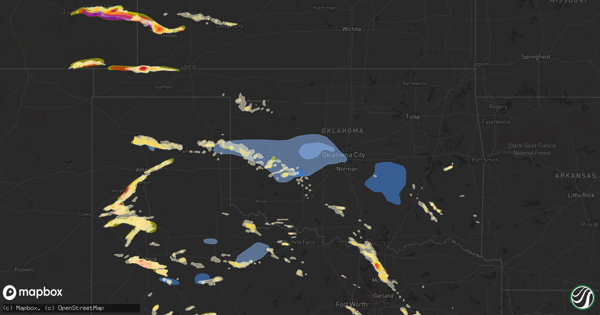
Hail Map in Oklahoma on June 23, 2023
Get this storm
June 23 map
$229
one time, instant access
Download today. No call, no setup
Keep the $229
Bought the map and want the full workflow? Apply the entire $229 to a subscription within 7 days. None of it is wasted.
Every map, not just this one
This buys you this map. Subscription and you get every map we run, in the markets you choose from a few cities to whole states to nationwide. Plus real-time alerts the moment a storm fires.
Contact data
Name, contact info, occupancy, even credit band for addresses in the footprint. You go from where it hit to who to call.
Become the source they trust
Unlimited branding weather history reports on demand. You already have the documented answer ready for the property owner, and you are the one who showed up with it.
Property data and RoofTrace estimates
Pull up any address you have got, its value and the exact code rules for that jurisdiction, straight from One Click Code. Then RoofTrace estimates the squares, pitch, and roof value, priced the way you price.
Storm reports in Oklahoma
Oklahoma
| Date | Description |
|---|---|
| 06/23/20233:51 PM CDT | A few light poles blown down. Large limbs and trees broken. Time estimated by radar. |
| 06/23/20233:45 PM CDT | Oklahoma mesonet. |
| 06/23/20232:19 PM CDT | A local report indicates 60 MPH wind near 2 NE Ada |
| 06/23/20231:00 PM CDT | Tree down. |
| 06/23/202312:32 PM CDT | A local report indicates 59 MPH wind near 2 WNW Warr Acres |
| 06/23/202312:30 PM CDT | 8-inch diameter tree snapped. Time estimated via radar. |
| 06/23/202312:15 PM CDT | A local report indicates 60 MPH wind near 5 SSW El Reno |
| 06/23/202312:00 PM CDT | A local report indicates 76 MPH wind near 3 SSE Fort Cobb Reservo |
| 06/23/202311:54 AM CDT | Report from mping: half dollar |
| 06/23/202311:45 AM CDT | A local report indicates 69 MPH wind near 2 W Kingfisher |
| 06/23/202311:45 AM CDT | Corrects previous tstm wnd gst report from 2 w kingfisher. Wind gust occurred at watonga mesonet site. |
| 06/23/202310:53 AM CDT | A local report indicates 63 MPH wind near 1 WSW Burns Flat |
| 06/23/202310:45 AM CDT | A local report indicates 66 MPH wind near 3 WNW Foss Reservoir |
| 06/23/202310:38 AM CDT | Report from mping: 3-inch tree limbs broken; power poles broken. |
| 06/23/202310:33 AM CDT | Report from mping: quarter |
| 06/22/20239:17 PM CDT | Time estimated by radar. |
| 06/22/20237:50 PM CDT | Based on pictures and spotter reports. Still on the ground as of 8:13 pm cdt. |
| 06/22/20237:08 PM CDT | Time estimated by radar. |
All States Impacted by Hail Map on June 23, 2023
Cities Impacted by Hail Map on June 23, 2023
- Perry, FL
- Mayo, FL
- Day, FL
- Daphne, AL
- Channing, TX
- Masterson, TX
- Dumas, TX
- Amarillo, TX
- Fritch, TX
- Panhandle, TX
- Borger, TX
- Canadian, TX
- Briscoe, TX
- Reydon, OK
- Wheeler, TX
- Mobeetie, TX
- Sweetwater, OK
- Hammon, OK
- Butler, OK
- Cheyenne, OK
- Custer City, OK
- Clinton, OK
- Cordell, OK
- Elk City, OK
- Dill City, OK
- Sentinel, OK
- Sayre, OK
- Canute, OK
- Foss, OK
- Arapaho, OK
- Electra, TX
- Iowa Park, TX
- Bessie, OK
- Thomas, OK
- Corn, OK
- Weatherford, OK
- Gotebo, OK
- Rocky, OK
- Hobart, OK
- Holliday, TX
- Hydro, OK
- Colony, OK
- Carnegie, OK
- Mountain View, OK
- Fort Cobb, OK
- Gracemont, OK
- Lookeba, OK
- Binger, OK
- Anadarko, OK
- Hinton, OK
- Geary, OK
- Calumet, OK
- Watonga, OK
- Greenfield, OK
- Okarche, OK
- Kingfisher, OK
- Omega, OK
- Minco, OK
- El Reno, OK
- Union City, OK
- Pocasset, OK
- Chickasha, OK
- Oklahoma City, OK
- Yukon, OK
- Piedmont, OK
- Edmond, OK
- Mustang, OK
- Tuttle, OK
- Bethany, OK
- Newcastle, OK
- Wheatland, OK
- Gordon, NE
- Sharon, OK
- Fargo, OK
- Arnett, OK
- Apache, OK
- Lander, WY
- Mutual, OK
- Woodward, OK
- Gage, OK
- Shattuck, OK
- Wichita Falls, TX
- Skellytown, TX
- Justin, TX
- Argyle, TX
- Frederick, OK
- Davidson, OK
- Loveland, OK
- Elgin, OK
- Pampa, TX
- Grandfield, OK
- Burkburnett, TX
- Chester, OK
- Cody, NE
- Cut Off, LA
- Carter, OK
- Crowell, TX
- Loving, TX
- Olney, TX
- Merriman, NE
- Vernon, TX
- Miami, TX
- Valentine, NE
- Lockport, LA
- Jermyn, TX
- Seymour, TX
- Decatur, TX
- Scotland, TX
- Archer City, TX
- Windthorst, TX
- Fletcher, OK
- Mooreland, OK
- Cyril, OK
- Flower Mound, TX
- Shamrock, TX
- Laverne, OK
- Shoshoni, WY
- Riverton, WY
- Lysite, WY
- Jeffrey City, WY
- Arapahoe, WY
- Seminole, OK
- Bowlegs, OK
- Maud, OK
- Wewoka, OK
- Earlsboro, OK
- Konawa, OK
- Sasakwa, OK
- Holdenville, OK
- Stonewall, OK
- Ada, OK
- Allen, OK
- Asher, OK
- Stratford, OK
- Byars, OK
- Wanette, OK
- Ten Sleep, WY
- Tupelo, OK
- Atwood, OK
- Wetumka, OK
- Calvin, OK
- Okemah, OK
- Casper, WY
- Hiland, WY
- Centrahoma, OK
- Coalgate, OK
- Stuart, OK
- Lamar, OK
- Dustin, OK
- Arminto, WY
- Kaycee, WY
- Gainesville, TX
- Whitesboro, TX
- Sadler, TX
- Canton, TX
- Snow, OK
- Stigler, OK
- Whitefield, OK
- Las Animas, CO
- Collinsville, TX
- Gunter, TX
- Howe, TX
- Tioga, TX
- Sherman, TX
- Midwest, WY
- Pilot Point, TX
- Celina, TX
- Van Alstyne, TX
- Anna, TX
- Immokalee, FL
- Spearfish, SD
- Lead, SD
- Mckinney, TX
- Melissa, TX
- Hasty, CO
- Friona, TX
- Dimmitt, TX
- Hereford, TX
- Midkiff, TX
- Harrold, SD
- Onida, SD
- Saint Onge, SD
- Sauk Centre, MN
- Glenrock, WY
- Broadus, MT
- Otter, MT
- Muleshoe, TX
- Douglas, WY
- Wheatland, WY
- Tripp, SD
- Kim, CO
- Lamar, CO
- Littlefield, TX
- Fieldton, TX
- Amherst, TX
- Levelland, TX
- Ropesville, TX
- Lubbock, TX
- Olivet, SD
- Niobrara, NE
- Center, NE
- Canyon, TX
- Verdigre, NE
- Holly, CO
- Granada, CO
- Hart, TX
- Belle Fourche, SD
- Nisland, SD
- Pritchett, CO
- Hale Center, TX
- Olton, TX
- Wolfforth, TX
- Smyer, TX
- Bloomfield, NE
- Gail, TX
- Shallowater, TX
- Yoder, WY
- Stratton, CO
- Vona, CO
- Loraine, TX
- Colorado City, TX
- Westbrook, TX
- Newell, SD
- Plainview, TX
- Springlake, TX
- Ree Heights, SD
- Miller, SD
- Campo, CO
- Kress, TX
- Wausa, NE
- Crofton, NE
- Hartington, NE
- Sudan, TX
- Earth, TX
- Slaton, TX
- Gillette, WY
- Groom, TX
- Roscoe, TX
- Ransom Canyon, TX
- Bethune, CO
- Mertzon, TX
- San Angelo, TX
- Burlington, CO
- Kirk, CO
- Idalia, CO
- Danbury, WI
- Hulett, WY
- Roberts, ID
- Brimson, MN
- Lame Deer, MT
- Clovis, NM
- Fairfield, MT
- Idaho Falls, ID
- Iron Belt, WI
- White Sulphur Springs, MT
- Fort Shaw, MT
- Vaughn, MT
- Buffalo, WY
- Alzada, MT
- Jacksonville, TX
- Bullard, TX
- Clearmont, WY
- Talihina, OK
- Dryden, TX
- Lafitte, LA
- Belle Chasse, LA
- Tyler, TX
- Frostproof, FL
- Athens, TX
- Wagner, SD
- North Bend, NE
- Ozona, TX
- Big Lake, TX
- Murchison, TX
- Ben Wheeler, TX
- Henderson, TX
- Clayton, OK
- Sheridan, WY
- Kenansville, FL
- Duncan, OK
- Marlow, OK
- Farmersville, TX
- Dodge, NE
- Tussy, OK
- Elmore City, OK
- Lenorah, TX
- Knott, TX
- Eustace, TX
- Blackshear, GA
- Garden City, TX
- Edgerton, WY
- Fort Worth, TX
- Burleson, TX
- Mansfield, TX
- River Ranch, FL
- Lake Wales, FL
- Finley, OK
- Daisy, OK
- Antlers, OK
- Pittsburg, OK
- Stringtown, OK
- Rattan, OK
- Robert Lee, TX
- Burneyville, OK
- Sylvania, GA
- Weston, WY
- North Branch, MN
- Jacksboro, TX
- Palestine, TX
- Rusk, TX
- Thackerville, OK
- Marietta, OK
- Sterling City, TX
- Alto, TX
- Hennepin, OK
- Overbrook, OK
- Ardmore, OK
- Prosper, TX
- Princeton, TX
- Gordonville, TX
- Long Branch, TX
- Garrison, TX
- Melbourne, FL
- Floyd, NM
- Portales, NM
- Elida, NM
- Stacy, MN
- Kinta, OK
- Ratliff City, OK
- Farwell, TX
- Madill, OK
- Wills Point, TX
- Terrell, TX
- Cumby, TX
- Watson, OK
- Saint Cloud, FL
- Avon, SD
- Dante, SD
- Flint, TX
- Midlothian, TX
- Alvarado, TX
- Arlington, TX
- Kennedale, TX
- Venus, TX
- Freeport, MN
- Melrose, MN
- Choteau, MT
- Mcalester, OK
- Kiowa, OK
- Wardville, OK
- Homerville, GA
- Brownsboro, TX
- Mount Enterprise, TX
- Timpson, TX
- Punta Gorda, FL
- Graham, OK
- Springer, OK
- Montalba, TX
- Lynch, NE
- Bristow, NE
- Broadview, MT
- Simms, MT
- Cascade, MT
- Coleridge, NE
- Lorenzo, TX
- Vernon, CO
- Wray, CO
- Christoval, TX
- Houston, TX
- Galena Park, TX
- Sweetwater, TX
- Kissimmee, FL
- Wilson, TX
- Post, TX
- Hawk Springs, WY
- Torrington, WY
- Dequincy, LA
- Singer, LA
- Lyman, NE
- Mitchell, NE
- Morrill, NE
- Mud Butte, SD
- Newcastle, WY
- Shawnee, WY
- Syracuse, KS
- Wall, TX
- Vancourt, TX
- Eola, TX
- Miles, TX
- Paint Rock, TX
- Mereta, TX
- Eldorado, TX
- Aladdin, WY
- Union Center, SD
- Sulphur, LA
- Lake Charles, LA
- Westlake, LA
- Haigler, NE
- Goodland, KS
- Briggsdale, CO
- Millersview, TX
- Eden, TX
- Menard, TX
- Kendall, KS
- Rule, TX
- Idalou, TX
- Old Glory, TX
- Haskell, TX
- Dickens, TX
- Petersburg, TX
- Crosbyton, TX
- Ralls, TX
- Spur, TX
- Abernathy, TX
- Sturgis, SD
- Boise City, OK
- New Underwood, SD
- Keyes, OK
- Elkhart, KS
- Goodwell, OK
- Walsh, CO
- Scottsbluff, NE
- Manderson, SD
- Gering, NE
- Porcupine, SD
- Pine Ridge, SD
- Kyle, SD
- Rapid City, SD
- Hermosa, SD
- Keystone, SD
- Long Valley, SD
- White River, SD
- Murdo, SD
- Johnson, KS
- Cypress, TX
- Box Elder, SD
- Holyoke, CO
- Haxtun, CO
- Ovid, CO
- Minatare, NE
- Philip, SD
- Quinn, SD
- Milesville, SD
- Midland, SD
- Ulysses, KS
- Scenic, SD
- Caputa, SD
- Rolla, KS
- Belvidere, SD
- Draper, SD
- New Raymer, CO
- Bayard, NE
- Angora, NE
- Orchard, CO
- Weldona, CO
- Ellsworth, NE
- Rushville, NE
- Fort Morgan, CO
- Faith, SD
- Julesburg, CO
- Melvin, TX
- Justiceburg, TX
- Big Springs, NE
- Chappell, NE
- Aspermont, TX
- Jayton, TX
- Snyder, TX
- Girard, TX
- Oshkosh, NE
- Lodgepole, NE
- Wanblee, SD
- Guymon, OK
- Hugoton, KS
- Interior, SD
- Presho, SD
- Kennebec, SD
- Lewellen, NE
- Hempstead, TX
- Waller, TX
- Oakdale, NE
- Neligh, NE
- Tilden, NE
- Snyder, CO
- Stoneham, CO
- Merino, CO
- Bingham, NE
- Ashby, NE
- Kadoka, SD
- Satanta, KS
- Meadow Grove, NE
- Ewing, NE
- Inman, NE
- Page, NE
- Garden City, KS
- Hooker, OK
- Orchard, NE
- Plainview, NE
- Bridgeport, NE
- Dodge City, KS
- Wright, KS
- Dupree, SD
- Whitman, NE
- Okaton, SD
- Dix, NE
- Sidney, NE
- Potter, NE
- Peetz, CO
- Padroni, CO
- Sterling, CO
- Iliff, CO
- Crook, CO
- Sedgwick, CO
- Fleming, CO
- Hyannis, NE
- Atwood, CO
- Lakeside, NE
- Lemoyne, NE
- Brule, NE
- Venango, NE
- Ogallala, NE
- Arthur, NE
- Keystone, NE
- Fort Laramie, WY
- Paxton, NE
- Sutherland, NE
- Tryon, NE
- Hayes, SD
- Fort Pierre, SD
- Royal, NE
- Springview, NE
- Paducah, TX
- Hershey, NE
- North Platte, NE
- Knox City, TX
- Crookston, NE
- Munday, TX
- Goree, TX
- Benjamin, TX
- Brady, TX
- Lohn, TX
- Vivian, SD
- Stapleton, NE
- Seneca, NE
- Mullen, NE
- Thedford, NE
- Chandler, TX
- Foley, MN
- Orting, WA
- Carlsbad, TX
- Eatonville, WA
- Labelle, FL
- Sundance, WY
- Orlando, FL
- Hermleigh, TX
- Center, TX
- Big Spring, TX
- Oneill, NE
- Katy, TX
- Burke, SD
- Venus, FL
- Moore Haven, FL
- Piedmont, SD
- Devils Tower, WY
- Beulah, WY
- Kaufman, TX
- Lusk, WY
- Lance Creek, WY
- Platte, SD
- Big Sandy, TX
- Royse City, TX
- Winner, SD
- Wayne, NE
- Wakefield, NE
- Hay Springs, NE
- Coahoma, TX
- Larue, TX
- Tennessee Colony, TX
- Edgewood, TX
- Childress, TX
- Deer Park, TX
- Tenaha, TX
- Shelbyville, TX
- San Augustine, TX
- Whitehouse, TX
- Rockledge, FL
- Iowa, LA
- Ragley, LA
- Kinder, LA
- Chugwater, WY
- Altamonte Springs, FL
- Maitland, FL
- Casselberry, FL
- Humble, TX
- Rocky Ford, GA
- Bassett, NE
- Vidor, TX
- Buna, TX
- Deweyville, TX
- Starks, LA
- Guernsey, WY
- Jay Em, WY
- Hockley, TX
- Maryneal, TX
- Chillicothe, TX
- Quanah, TX
- Bellaire, TX
- Pasadena, TX
- South Houston, TX
- Randolph, NE
- Springfield, SD
- McCamey, TX
- Kilgore, TX
- Gladewater, TX
- Whitewood, SD
- Reeves, LA
- Troup, TX
- Ideal, SD
- Anton, TX
- Ackerly, TX
- Laurel, NE
- Nazareth, TX
- Overton, TX
- Clearwater, NE
- Long Pine, NE
- Pierson, FL
- Lavon, TX
- Nevada, TX
- Happy, TX
- Decker, MT
- Kerens, TX
- Lake Mary, FL
- Longwood, FL
- Rice, TX
- Lehigh Acres, FL
- Cocoa Beach, FL
- Iraan, TX
- Astor, FL
- Veteran, WY
- Brashear, TX
- Lamesa, TX
- Tulia, TX
- Apopka, FL
- Highlands, TX
- Maxwell, NE
- Brady, NE
- Arnold, NE
- Norris, SD
- Parmelee, SD
- Sparks, NE
- Mission, SD
- Colome, SD
- Dutton, MT
- Terreton, ID
- Dunning, NE
- Anselmo, NE
- Halsey, NE
- Purdum, NE
- Brewster, NE
- Lower Brule, SD
- Dallas, SD
- Gregory, SD
- Mills, NE
- Saint Francis, SD
- Rosebud, SD
- Eagle Butte, SD
- Ridgeview, SD
- Agar, SD
- Gettysburg, SD
- Pierre, SD
- Blunt, SD
- Hamill, SD
- Chamberlain, SD
- Oacoma, SD
- Pukwana, SD
- Reliance, SD
- Fort Thompson, SD
- Gann Valley, SD
- Herrick, SD
- Stuart, NE
- Naper, NE
- Newport, NE
- Broken Bow, NE
- Sargent, NE
- Burwell, NE
- Taylor, NE
- Ainsworth, NE
- Lebanon, SD
- Saint Charles, SD
- Bonesteel, SD
- Atkinson, NE
- Butte, NE
- Kimball, SD
- White Lake, SD
- Woonsocket, SD
- Wessington Springs, SD
- Wessington, SD
- Holabird, SD
- Stephan, SD
- Highmore, SD
- Alpena, SD
- Saint Lawrence, SD
- Wolsey, SD
- Virgil, SD
- Huron, SD
- Hitchcock, SD
- Redfield, SD
- Tulare, SD
- Ord, NE
- Elyria, NE
- Rockham, SD
- Orient, SD
- Doland, SD
- Ashton, SD
- Frankfort, SD
- Scotia, NE
- Spalding, NE
- Greeley, NE
- Ericson, NE
- Albion, NE
- Elgin, NE
- Petersburg, NE
- Bartlett, NE
- Emmet, NE
- Amelia, NE
- Chambers, NE
- Saint Helena, NE
- Yankton, SD
- Winnetoon, NE
- Tabor, SD
- Tyndall, SD
- Lesterville, SD
- Utica, SD
- Mission Hill, SD
- Vermillion, SD
- Volin, SD
- Centerville, SD
- Beresford, SD
- Irene, SD
- Wakonda, SD
- Menno, SD
- Viborg, SD
- Lennox, SD
- Marion, SD
- Parker, SD
- Hurley, SD
- Davis, SD
- Freeman, SD
- Fordyce, NE
- Gayville, SD
- Alcester, SD
- Hawarden, IA
- Wynot, NE
- Elk Point, SD
- Burbank, SD
- Hudson, SD
- Canton, SD
- Chancellor, SD
- Sioux Falls, SD
- Hartford, SD
- Worthing, SD
- Tea, SD
- Harrisburg, SD
- Scotland, SD
- Rock Valley, IA
- Fairview, SD
- Inwood, IA
- Larchwood, IA
- Brandon, SD
- Renner, SD
- Valley Springs, SD
- Garretson, SD
- Dell Rapids, SD
- Baltic, SD
- Crooks, SD
- Spencer, NE
- Farwell, NE
- Saint Paul, NE
- Kimball, NE
- Richland Springs, TX
- Comstock, NE
- Palmer, NE
- Fullerton, NE
- Rochelle, TX
- Goldthwaite, TX
- Mullin, TX
- San Saba, TX
- Lagrange, WY
- Harrisburg, NE
- Rockville, NE
- Cimarron, KS
- Gatesville, TX
- Brookesmith, TX
- Brownwood, TX
- Ingalls, KS
- Pierceville, KS
- Lakin, KS
- Central City, NE
- Lost Springs, WY
- Brunswick, NE
- Creighton, NE
- Alliance, NE
- Mcadoo, TX
- Early, TX
- Ashton, NE
- Clarks, NE
- Holcomb, KS
- Fairfax, SD
- Zephyr, TX
- Hamilton, TX
- Pickstown, SD
- Lake Andes, SD
- Broadwater, NE
- Kilgore, NE
- Dalton, NE
- Gurley, NE
- Lampasas, TX
- Prairie View, TX
- Trent, SD
- Flandreau, SD
- Luverne, MN
- Jasper, MN
- Pipestone, MN
- Holland, MN
- Ruthton, MN
- Balaton, MN
- Ivanhoe, MN
- Elkton, SD
- Russell, MN
- Lake Benton, MN
- Arco, MN
- Tyler, MN
- Marshall, MN
- Lynd, MN
- Ghent, MN
- Minneota, MN
- Taunton, MN
- Edgerton, MN
- Woodstock, MN
- Deadwood, SD
- Genoa, NE
- Blair, NE
- Lawton, IA
- Hinton, IA
- Le Mars, IA
- Merrill, IA
- Sioux City, IA
- Kenneth, MN
- Boelus, NE
- Silver Creek, NE
- Kennard, NE
- Modale, IA
- Arlington, NE
- Missouri Valley, IA
- Herman, NE
- Nickerson, NE
- Litchfield, NE
- Ravenna, NE
- Loup City, NE
- Granville, IA
- Alton, IA
- Wood, SD
- Delmont, SD
- Monroe, NE
- Columbus, NE
- Clarkson, NE
- Madison, SD
- Ramona, SD
- Lismore, MN
- Marcus, IA
- Chandler, MN
- Remsen, IA
- Wolbach, NE
- Belgrade, NE
- Duncan, NE
- Lake Preston, SD
- Erwin, SD
- Holstein, IA
- Battle Creek, IA
- Sioux Rapids, IA
- Alta, IA
- Galva, IA
- Schaller, IA
- Cleghorn, IA
- Laurens, IA
- Albert City, IA
- Linn Grove, IA


