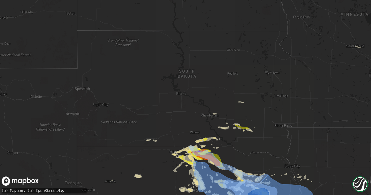
Hail Map in South Dakota on June 23, 2021
Get this storm
June 23 map
$229
one time, instant access
Download today. No call, no setup
Keep the $229
Bought the map and want the full workflow? Apply the entire $229 to a subscription within 7 days. None of it is wasted.
Every map, not just this one
This buys you this map. Subscription and you get every map we run, in the markets you choose from a few cities to whole states to nationwide. Plus real-time alerts the moment a storm fires.
Contact data
Name, contact info, occupancy, even credit band for addresses in the footprint. You go from where it hit to who to call.
Become the source they trust
Unlimited branding weather history reports on demand. You already have the documented answer ready for the property owner, and you are the one who showed up with it.
Property data and RoofTrace estimates
Pull up any address you have got, its value and the exact code rules for that jurisdiction, straight from One Click Code. Then RoofTrace estimates the squares, pitch, and roof value, priced the way you price.
Storm reports in South Dakota
South Dakota
| Date | Description |
|---|---|
| 06/23/20216:58 PM CDT | Estimated up to 60mph |
| 06/23/20214:47 AM CDT | At 947 PM CDT, a severe thunderstorm was located 10 miles north of Newport, or 15 miles northeast of Bassett, moving east at 30 mph. HAZARD...Two inch hail and 60 mph wind gusts. SOURCE...Radar indicated. IMPACT...People and animals outdoors will be injured. Expect hail damage to roofs, siding, windows, and vehicles. Expect wind damage to roofs, siding, and trees. Locations impacted include... Atkinson, Stuart, Butte, Newport, Naper, Emmet, Dustin, Anoka, Hull Lake State Wildlife Management Area, Mariaville, Mills, Brocksburg and Parshall Bridge State Wildlife Management Area.This includes the following highways... Highway 20 between mile markers 263 and 298. Highway 12 between mile markers 68 and 118. |
| 06/23/20214:28 AM CDT | At 927 PM CDT, a severe thunderstorm was located near Norden, or 11 miles west of Springview, moving east at 30 mph. HAZARD...60 mph wind gusts and quarter size hail. SOURCE...Radar indicated. IMPACT...Hail damage to vehicles is expected. Expect wind damage to roofs, siding, and trees. Locations impacted include... Springview, Norden and Burton. This includes the following highways... Highway 183 between mile markers 212 and 224. Highway 12 between mile markers 28 and 67. |
| 06/23/20213:44 AM CDT | At 844 PM CDT, a severe thunderstorm was located 8 miles southwest of Wewela, or 9 miles northwest of Springview, moving east at 30 mph. HAZARD...60 mph wind gusts and quarter size hail. SOURCE...Trained weather spotters. IMPACT...Hail damage to vehicles is expected. Expect wind damage to roofs, siding, and trees. Locations impacted include... Springview, Norden, Burton, Nets Peak, Mills and Brocksburg. This includes the following highways... Highway 183 between mile markers 212 and 225. Highway 12 between mile markers 23 and 83. |
| 06/23/20213:36 AM CDT | At 835 PM CDT, a severe thunderstorm was located near Stickney, or 12 miles southeast of Plankinton, moving east at 25 mph. HAZARD...60 mph wind gusts and quarter size hail. SOURCE...Trained weather spotters. Quarter size hail was reported south of Stickney. IMPACT...Hail damage to vehicles is expected. Expect wind damage to roofs, siding, and trees. This severe thunderstorm will be near... Ethan and Dimock around 915 PM CDT. |
| 06/23/20213:30 AM CDT | At 830 PM CDT, a severe thunderstorm was located 6 miles south of Millboro, or 15 miles northwest of Springview, moving east at 30 mph. HAZARD...Ping pong ball size hail and 60 mph wind gusts. SOURCE...Radar indicated. IMPACT...People and animals outdoors will be injured. Expect hail damage to roofs, siding, windows, and vehicles. Expect wind damage to roofs, siding, and trees. This severe thunderstorm will be near... Wewela around 850 PM CDT. |
| 06/23/20213:05 AM CDT | At 805 PM CDT, a severe thunderstorm was located near Aurora Center, or 17 miles southwest of Plankinton, moving east at 20 mph. HAZARD...60 mph wind gusts and quarter size hail. SOURCE...Radar indicated. IMPACT...Hail damage to vehicles is expected. Expect wind damage to roofs, siding, and trees. This severe thunderstorm will be near... New Holland around 815 PM CDT. Aurora Center around 820 PM CDT. Harrison around 830 PM CDT. Corsica and Stickney around 845 PM CDT. |
| 06/23/20212:46 AM CDT | At 745 PM CDT, a severe thunderstorm was located 7 miles southeast of Stickney, or 15 miles southeast of Plankinton, moving east at 20 mph. HAZARD...60 mph wind gusts and quarter size hail. SOURCE...Radar indicated. IMPACT...Hail damage to vehicles is expected. Expect wind damage to roofs, siding, and trees. This severe thunderstorm will be near... Ethan and Dimock around 830 PM CDT. |
| 06/23/20212:12 AM CDT | At 712 PM CDT, a severe thunderstorm was located near Dallas, or 20 miles southeast of Winner, moving east at 35 mph. HAZARD...60 mph wind gusts and half dollar size hail. SOURCE...Radar indicated. IMPACT...Hail damage to vehicles is expected. Expect wind damage to roofs, siding, and trees. This severe thunderstorm will be near... Dallas around 715 PM CDT. Gregory around 725 PM CDT. Burke around 735 PM CDT. Herrick around 745 PM CDT.Other locations impacted by this severe thunderstorm include Fairfax. |
| 06/23/20211:58 AM CDT | At 658 PM CDT, a severe thunderstorm was located 7 miles south of Colome, or 16 miles south of Winner, moving east at 30 mph. HAZARD...60 mph wind gusts and quarter size hail. SOURCE...Radar indicated. IMPACT...Hail damage to vehicles is expected. Expect wind damage to roofs, siding, and trees. This severe thunderstorm will remain over mainly rural areas of southeastern Tripp County between Colome and Wewela. |
| 06/23/202112:19 AM CDT | At 519 PM CDT, a severe thunderstorm was located 7 miles northwest of Springview, moving east at 35 mph. HAZARD...60 mph wind gusts and half dollar size hail. SOURCE...Radar indicated. IMPACT...Hail damage to vehicles is expected. Expect wind damage to roofs, siding, and trees. Locations impacted include... Springview, Burton, Nets Peak, Thomas Creek State Wildlife Management Area, Mills and Brocksburg.This includes the following highways... Highway 183 between mile markers 210 and 223. Highway 12 between mile markers 35 and 86. |
| 06/22/20219:00 PM CDT | Winds estimated around 60 mph. Lots of small branches down with a large amount of fruit blown off trees. Spotter estimated strongest wind was around 9 pm. |
| 06/22/20218:40 PM CDT | A local report indicates 60 MPH wind near 4 SSE MILLBORO |
| 06/22/20218:14 PM CDT | Reported at fort randall dam rwis observing site. |
| 06/22/20218:12 PM CDT | Estimated 50 mph winds with the quarter size hail. |
| 06/22/20217:30 PM CDT | Sheriff reported quarter size hail. |
All States Impacted by Hail Map on June 23, 2021
Cities Impacted by Hail Map on June 23, 2021
- Saint Paul, NE
- Wood Lake, NE
- Edgar, NE
- Nelson, NE
- Superior, NE
- Gothenburg, NE
- Brady, NE
- Callaway, NE
- Delia, KS
- Mayetta, KS
- Gretna, NE
- Springfield, NE
- Ashland, NE
- South Bend, NE
- Omaha, NE
- Hayward, WI
- Ravenna, NE
- Burwell, NE
- Clearwater, NE
- Keshena, WI
- Worden, MT
- Shepherd, MT
- Parkston, SD
- Dimock, SD
- Hardy, NE
- Hinckley, MN
- Schofield, WI
- Cornucopia, WI
- Bayfield, WI
- Burlington, CO
- Mills, NE
- Springview, NE
- Giltner, NE
- Valentine, NE
- Cotton, MN
- Burke, SD
- Randolph, NE
- Pierce, NE
- Spalding, NE
- Greeley, NE
- Ericson, NE
- Scotia, NE
- Long Pine, NE
- Bassett, NE
- Atkinson, NE
- Winner, SD
- Johnstown, NE
- Sparks, NE
- Newport, NE
- Stuart, NE
- Ainsworth, NE
- Elgin, NE
- Amelia, NE
- Chambers, NE
- Bartlett, NE
- Falls City, NE
- Colome, SD
- Alexander, KS
- Elgin, OR
- Duluth, MN
- Mount Vernon, SD
- Stickney, SD
- Ashby, NE
- Merriman, NE
- Phillips, WI
- Fifield, WI
- Page, NE
- Ewing, NE
- Orchard, NE
- Royal, NE
- Neligh, NE
- Inman, NE
- Shell Lake, WI
- Siren, WI
- Frederic, WI
- Webster, WI
- Arapahoe, CO
- Mankato, KS
- Hibbing, MN
- Ness City, KS
- Bazine, KS
- Ogallah, KS
- Wakeeney, KS
- Ellis, KS
- Cecil, WI
- Stratton, CO
- Columbus, NE
- Schuyler, NE
- Red Level, AL
- Andalusia, AL
- Bend, OR
- Madison, NE
- Albion, NE
- Troy, KS
- Wathena, KS
- Danbury, WI
- Wausau, WI
- Sandstone, MN
- Lewellen, NE
- Harvard, NE
- Esko, MN
- Cloquet, MN
- Dix, NE
- Potter, NE
- Petersburg, NE
- Dallas, SD
- Kimball, NE
- Aurora, NE
- Phillips, NE
- Unadilla, NE
- Palmyra, NE
- Lincoln, NE
- Eagle, NE
- Walton, NE
- Elmwood, NE
- Bennet, NE
- Brewster, NE
- Taylor, NE
- Grantsburg, WI
- Weeping Water, NE
- Avoca, NE
- Talmage, NE
- Lublin, WI
- Elgin, AZ
- Sonoita, AZ
- Rice Lake, WI
- Palco, KS
- Makinen, MN
- Cameron, WI
- Weyerhaeuser, WI
- Bruce, WI
- Chetek, WI
- Cairo, NE
- Wood River, NE
- Doniphan, NE
- Platte, SD
- Mosinee, WI
- Lavina, MT
- Two Harbors, MN
- Clay Center, NE
- Shawano, WI
- White Lake, SD
- Kimball, SD
- Hornick, IA
- Sloan, IA
- Whiting, IA
- Shelton, NE
- Gregory, SD
- Clarkson, NE
- Chisholm, MN
- Purdum, NE
- Dunning, NE
- Truxton, MO
- Lake Nebagamon, WI
- Belleville, KS
- Webber, KS
- Scandia, KS
- Courtland, KS
- Formoso, KS
- Jewell, KS
- Grand Island, NE
- Nebraska City, NE
- Percival, IA
- Nashwauk, MN
- Silver Creek, NE
- Roseland, NE
- Juniata, NE
- Crossroads, NM
- Solon Springs, WI
- Castana, IA
- Rodney, IA
- Smithland, IA
- Holton, KS
- Tuthill, SD
- Hertel, WI
- Gordon, WI
- Minong, WI
- Waterloo, NE
- Murdock, NE
- Yutan, NE
- Greenwood, NE
- Waverly, NE
- Cedar Creek, NE
- Wahoo, NE
- Ceresco, NE
- Mead, NE
- Memphis, NE
- Ithaca, NE
- Louisville, NE
- Kenesaw, NE
- Table Rock, NE
- Pawnee City, NE
- Merrill, WI
- Cumberland, WI
- Gilman, WI
- Holcombe, WI
- Withee, WI
- Thorp, WI
- Terrebonne, OR
- Redmond, OR
- McCracken, KS
- Hays, KS
- Schoenchen, KS
- Emmet, NE
- Wayne, NE
- Raymond, NE
- Davey, NE
- Bethune, CO
- Auburn, NE
- Brownville, NE
- Plattsmouth, NE
- Oregon, MO
- Forest City, MO
- Baldwin City, KS
- Lawrence, KS
- Rogers, NE
- Morse Bluff, NE
- Malmo, NE
- North Bend, NE
- Weston, NE
- Howells, NE
- Dodge, NE
- David City, NE
- Prague, NE
- Linwood, NE
- Saint Edward, NE
- Fullerton, NE
- Genoa, NE
- White Cloud, KS
- Highland, KS
- Robinson, KS
- Junction City, WI
- Healy, KS
- Dighton, KS
- Osmond, NE
- Brunswick, NE
- Plainview, NE
- Farwell, NE
- Dannebrog, NE
- Western, NE
- Dorchester, NE
- Crete, NE
- Wilber, NE
- Cable, WI
- Hatley, WI
- Butternut, WI
- Park Falls, WI
- Plainville, KS
- Brimson, MN
- Valparaiso, NE
- Douglas, NE
- Rib Lake, WI
- Medford, WI
- Athens, WI
- Colon, NE
- Norfolk, NE
- Humphrey, NE
- Lindsay, NE
- Leigh, NE
- Monroe, NE
- Meadow Grove, NE
- Oakdale, NE
- Creston, NE
- Battle Creek, NE
- Stanton, NE
- Tilden, NE
- Newman Grove, NE
- Central City, NE
- Hawk Point, MO
- Bellflower, MO
- Tucson, AZ
- Green Valley, AZ
- Weskan, KS
- Oak, NE
- Corsica, SD
- Eveleth, MN
- Circleville, KS
- Scott City, KS
- Herbster, WI
- Craig, MO
- Fairfax, MO
- Brookston, MN
- Carleton, NE
- Ruskin, NE
- Trego, WI
- Antigo, WI
- Emerson, NE
- Montgomery City, MO
- Middletown, MO
- Floodwood, MN
- Catawba, WI
- Evergreen, AL
- Brewton, AL
- Sargent, NE
- Clayton, KS
- Lenora, KS
- Brainard, NE
- Dwight, NE
- Brook Park, MN
- Trumbull, NE
- Hastings, NE
- Sterling, NE
- Burr, NE
- Hebron, NE
- Rulo, NE
- Verdon, NE
- Gibbon, NE
- Woonsocket, SD
- Mapleton, IA
- Burdett, KS
- McCool Junction, NE
- Luck, WI
- Fairfield, NE
- Oneill, NE
- Kearney, NE
- New Auburn, WI
- Guide Rock, NE
- Alexandria, SD
- Maple, WI
- Rock Port, MO
- Hamburg, IA
- Saint Cloud, MN
- Naper, NE
- Nemaha, NE
- Peru, NE
- Wittenberg, WI
- Roundup, MT
- Barronett, WI
- Halsey, NE
- Johnson, NE
- Tecumseh, NE
- Overbrook, KS
- Syracuse, NE
- Dunbar, NE
- Cook, NE
- Otoe, NE
- Lorton, NE
- Union, NE
- Brock, NE
- Murray, NE
- Nehawka, NE
- Julian, NE
- Grafton, NE
- Geneva, NE
- Forbes, MN
- Iron, MN
- Arivaca, AZ
- Monument, KS
- Soldier, KS
- Havensville, KS
- Sutton, NE
- Deshler, NE
- Eudora, KS
- Mountain Iron, MN
- Murphy, ID
- Castleberry, AL
- Keewatin, MN
- Friend, NE
- Pukwana, SD
- Labelle, FL
- Bonduel, WI
- Elyria, NE
- Sarona, WI
- Barron, WI
- Comstock, WI
- Gillett, WI
- Moore, ID
- Eland, WI
- Hoskins, NE
- Marathon, WI
- Birnamwood, WI
- Rosholt, WI
- Ringle, WI
- Rothschild, WI
- Thedford, NE
- Chapman, NE
- Alliance, NE
- Hordville, NE
- Seney, MI
- Salem, NE
- Dawson, NE
- Ute, IA
- Holstein, NE
- Saronville, NE
- Tigerton, WI
- Pep, NM
- Carroll, NE
- Portsmouth, IA
- Belgrade, NE
- Platte Center, NE
- Malcolm, NE
- Fort Calhoun, NE
- Winside, NE
- Staplehurst, NE
- Adams, NE
- Surprise, NE
- Pilger, NE
- Stromsburg, NE
- Mondamin, IA
- Kennard, NE
- Logan, IA
- Boys Town, NE
- Wisner, NE
- Gresham, NE
- Decatur, NE
- Tekamah, NE
- Tabor, IA
- Bennington, NE
- Bellwood, NE
- Uehling, NE
- Hickman, NE
- Pacific Junction, IA
- Crescent, IA
- Cedar Bluffs, NE
- Martell, NE
- Lyons, NE
- Primrose, NE
- Ulysses, NE
- Bruno, NE
- Moorhead, IA
- Abie, NE
- Garland, NE
- West Point, NE
- Elkhorn, NE
- Seward, NE
- Osceola, NE
- North Loup, NE
- Blencoe, IA
- Denton, NE
- Glenwood, IA
- Randolph, IA
- Blair, NE
- Cedar Rapids, NE
- Bee, NE
- Wolbach, NE
- Malvern, IA
- Persia, IA
- Little Sioux, IA
- Arlington, NE
- Ord, NE
- Rising City, NE
- Winslow, NE
- Milford, NE
- Sidney, IA
- Beemer, NE
- Minden, IA
- Carter Lake, IA
- Pleasant Dale, NE
- Clarks, NE
- Pender, NE
- Duncan, NE
- Honey Creek, IA
- Palmer, NE
- Snyder, NE
- Pisgah, IA
- Shelby, NE
- Woodbine, IA
- Dunlap, IA
- Modale, IA
- Watson, MO
- Onawa, IA
- Farragut, IA
- Thurman, IA
- Bellevue, NE
- Nickerson, NE
- Washington, NE
- Bancroft, NE
- Underwood, IA
- Shenandoah, IA
- Westboro, MO
- Missouri Valley, IA
- Broken Bow, NE
- Riverton, IA
- McClelland, IA
- Tarkio, MO
- La Vista, NE
- Ames, NE
- Blanchard, IA
- Valley, NE
- Neola, IA
- Roca, NE
- Manley, NE
- Herman, NE
- Hooper, NE
- Fremont, NE
- Council Bluffs, IA
- Coin, IA
- Alvo, NE
- Oakland, NE
- Scribner, NE
- Northboro, IA
- Papillion, NE
- Craig, NE
- Comstock, NE
- Magnolia, IA
- Offutt Afb, NE
- Ethan, SD


