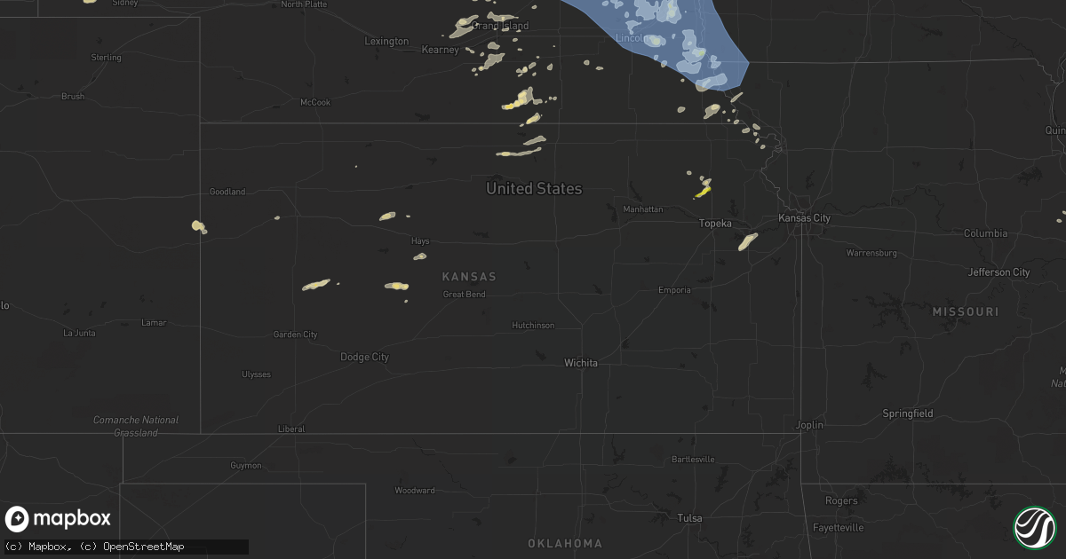
Hail Map in Kansas on June 23, 2021
Get this storm
June 23 map
$229
one time, instant access
Download today. No call, no setup
Keep the $229
Bought the map and want the full workflow? Apply the entire $229 to a subscription within 7 days. None of it is wasted.
Every map, not just this one
This buys you this map. Subscription and you get every map we run, in the markets you choose from a few cities to whole states to nationwide. Plus real-time alerts the moment a storm fires.
Contact data
Name, contact info, occupancy, even credit band for addresses in the footprint. You go from where it hit to who to call.
Become the source they trust
Unlimited branding weather history reports on demand. You already have the documented answer ready for the property owner, and you are the one who showed up with it.
Property data and RoofTrace estimates
Pull up any address you have got, its value and the exact code rules for that jurisdiction, straight from One Click Code. Then RoofTrace estimates the squares, pitch, and roof value, priced the way you price.
Storm reports in Kansas
Kansas
| Date | Description |
|---|---|
| 06/23/20216:58 PM CDT | Off duty employee reported 60mph gust. |
| 06/23/20215:58 AM CDT | A local report indicates 1.00 inch wind near 5 WNW MAYETTA |
| 06/23/20215:00 AM CDT | At 1000 PM CDT, a severe thunderstorm was located very near Amy, moving northeast at 20 mph. HAZARD...Quarter size hail. SOURCE...Radar indicated. IMPACT...Damage to vehicles is expected. This severe thunderstorm will be near... Dighton around 1020 PM CDT.Other locations in the path of this severe thunderstorm includeShields and Pendennis. |
| 06/22/20218:04 PM CDT | Site tcem colby. |
| 06/22/20217:53 PM CDT | Site four mile field. |
All States Impacted by Hail Map on June 23, 2021
Cities Impacted by Hail Map on June 23, 2021
- Saint Paul, NE
- Wood Lake, NE
- Edgar, NE
- Nelson, NE
- Superior, NE
- Gothenburg, NE
- Brady, NE
- Callaway, NE
- Delia, KS
- Mayetta, KS
- Gretna, NE
- Springfield, NE
- Ashland, NE
- South Bend, NE
- Omaha, NE
- Hayward, WI
- Ravenna, NE
- Burwell, NE
- Clearwater, NE
- Keshena, WI
- Worden, MT
- Shepherd, MT
- Parkston, SD
- Dimock, SD
- Hardy, NE
- Hinckley, MN
- Schofield, WI
- Cornucopia, WI
- Bayfield, WI
- Burlington, CO
- Mills, NE
- Springview, NE
- Giltner, NE
- Valentine, NE
- Cotton, MN
- Burke, SD
- Randolph, NE
- Pierce, NE
- Spalding, NE
- Greeley, NE
- Ericson, NE
- Scotia, NE
- Long Pine, NE
- Bassett, NE
- Atkinson, NE
- Winner, SD
- Johnstown, NE
- Sparks, NE
- Newport, NE
- Stuart, NE
- Ainsworth, NE
- Elgin, NE
- Amelia, NE
- Chambers, NE
- Bartlett, NE
- Falls City, NE
- Colome, SD
- Alexander, KS
- Elgin, OR
- Duluth, MN
- Mount Vernon, SD
- Stickney, SD
- Ashby, NE
- Merriman, NE
- Phillips, WI
- Fifield, WI
- Page, NE
- Ewing, NE
- Orchard, NE
- Royal, NE
- Neligh, NE
- Inman, NE
- Shell Lake, WI
- Siren, WI
- Frederic, WI
- Webster, WI
- Arapahoe, CO
- Mankato, KS
- Hibbing, MN
- Ness City, KS
- Bazine, KS
- Ogallah, KS
- Wakeeney, KS
- Ellis, KS
- Cecil, WI
- Stratton, CO
- Columbus, NE
- Schuyler, NE
- Red Level, AL
- Andalusia, AL
- Bend, OR
- Madison, NE
- Albion, NE
- Troy, KS
- Wathena, KS
- Danbury, WI
- Wausau, WI
- Sandstone, MN
- Lewellen, NE
- Harvard, NE
- Esko, MN
- Cloquet, MN
- Dix, NE
- Potter, NE
- Petersburg, NE
- Dallas, SD
- Kimball, NE
- Aurora, NE
- Phillips, NE
- Unadilla, NE
- Palmyra, NE
- Lincoln, NE
- Eagle, NE
- Walton, NE
- Elmwood, NE
- Bennet, NE
- Brewster, NE
- Taylor, NE
- Grantsburg, WI
- Weeping Water, NE
- Avoca, NE
- Talmage, NE
- Lublin, WI
- Elgin, AZ
- Sonoita, AZ
- Rice Lake, WI
- Palco, KS
- Makinen, MN
- Cameron, WI
- Weyerhaeuser, WI
- Bruce, WI
- Chetek, WI
- Cairo, NE
- Wood River, NE
- Doniphan, NE
- Platte, SD
- Mosinee, WI
- Lavina, MT
- Two Harbors, MN
- Clay Center, NE
- Shawano, WI
- White Lake, SD
- Kimball, SD
- Hornick, IA
- Sloan, IA
- Whiting, IA
- Shelton, NE
- Gregory, SD
- Clarkson, NE
- Chisholm, MN
- Purdum, NE
- Dunning, NE
- Truxton, MO
- Lake Nebagamon, WI
- Belleville, KS
- Webber, KS
- Scandia, KS
- Courtland, KS
- Formoso, KS
- Jewell, KS
- Grand Island, NE
- Nebraska City, NE
- Percival, IA
- Nashwauk, MN
- Silver Creek, NE
- Roseland, NE
- Juniata, NE
- Crossroads, NM
- Solon Springs, WI
- Castana, IA
- Rodney, IA
- Smithland, IA
- Holton, KS
- Tuthill, SD
- Hertel, WI
- Gordon, WI
- Minong, WI
- Waterloo, NE
- Murdock, NE
- Yutan, NE
- Greenwood, NE
- Waverly, NE
- Cedar Creek, NE
- Wahoo, NE
- Ceresco, NE
- Mead, NE
- Memphis, NE
- Ithaca, NE
- Louisville, NE
- Kenesaw, NE
- Table Rock, NE
- Pawnee City, NE
- Merrill, WI
- Cumberland, WI
- Gilman, WI
- Holcombe, WI
- Withee, WI
- Thorp, WI
- Terrebonne, OR
- Redmond, OR
- McCracken, KS
- Hays, KS
- Schoenchen, KS
- Emmet, NE
- Wayne, NE
- Raymond, NE
- Davey, NE
- Bethune, CO
- Auburn, NE
- Brownville, NE
- Plattsmouth, NE
- Oregon, MO
- Forest City, MO
- Baldwin City, KS
- Lawrence, KS
- Rogers, NE
- Morse Bluff, NE
- Malmo, NE
- North Bend, NE
- Weston, NE
- Howells, NE
- Dodge, NE
- David City, NE
- Prague, NE
- Linwood, NE
- Saint Edward, NE
- Fullerton, NE
- Genoa, NE
- White Cloud, KS
- Highland, KS
- Robinson, KS
- Junction City, WI
- Healy, KS
- Dighton, KS
- Osmond, NE
- Brunswick, NE
- Plainview, NE
- Farwell, NE
- Dannebrog, NE
- Western, NE
- Dorchester, NE
- Crete, NE
- Wilber, NE
- Cable, WI
- Hatley, WI
- Butternut, WI
- Park Falls, WI
- Plainville, KS
- Brimson, MN
- Valparaiso, NE
- Douglas, NE
- Rib Lake, WI
- Medford, WI
- Athens, WI
- Colon, NE
- Norfolk, NE
- Humphrey, NE
- Lindsay, NE
- Leigh, NE
- Monroe, NE
- Meadow Grove, NE
- Oakdale, NE
- Creston, NE
- Battle Creek, NE
- Stanton, NE
- Tilden, NE
- Newman Grove, NE
- Central City, NE
- Hawk Point, MO
- Bellflower, MO
- Tucson, AZ
- Green Valley, AZ
- Weskan, KS
- Oak, NE
- Corsica, SD
- Eveleth, MN
- Circleville, KS
- Scott City, KS
- Herbster, WI
- Craig, MO
- Fairfax, MO
- Brookston, MN
- Carleton, NE
- Ruskin, NE
- Trego, WI
- Antigo, WI
- Emerson, NE
- Montgomery City, MO
- Middletown, MO
- Floodwood, MN
- Catawba, WI
- Evergreen, AL
- Brewton, AL
- Sargent, NE
- Clayton, KS
- Lenora, KS
- Brainard, NE
- Dwight, NE
- Brook Park, MN
- Trumbull, NE
- Hastings, NE
- Sterling, NE
- Burr, NE
- Hebron, NE
- Rulo, NE
- Verdon, NE
- Gibbon, NE
- Woonsocket, SD
- Mapleton, IA
- Burdett, KS
- McCool Junction, NE
- Luck, WI
- Fairfield, NE
- Oneill, NE
- Kearney, NE
- New Auburn, WI
- Guide Rock, NE
- Alexandria, SD
- Maple, WI
- Rock Port, MO
- Hamburg, IA
- Saint Cloud, MN
- Naper, NE
- Nemaha, NE
- Peru, NE
- Wittenberg, WI
- Roundup, MT
- Barronett, WI
- Halsey, NE
- Johnson, NE
- Tecumseh, NE
- Overbrook, KS
- Syracuse, NE
- Dunbar, NE
- Cook, NE
- Otoe, NE
- Lorton, NE
- Union, NE
- Brock, NE
- Murray, NE
- Nehawka, NE
- Julian, NE
- Grafton, NE
- Geneva, NE
- Forbes, MN
- Iron, MN
- Arivaca, AZ
- Monument, KS
- Soldier, KS
- Havensville, KS
- Sutton, NE
- Deshler, NE
- Eudora, KS
- Mountain Iron, MN
- Murphy, ID
- Castleberry, AL
- Keewatin, MN
- Friend, NE
- Pukwana, SD
- Labelle, FL
- Bonduel, WI
- Elyria, NE
- Sarona, WI
- Barron, WI
- Comstock, WI
- Gillett, WI
- Moore, ID
- Eland, WI
- Hoskins, NE
- Marathon, WI
- Birnamwood, WI
- Rosholt, WI
- Ringle, WI
- Rothschild, WI
- Thedford, NE
- Chapman, NE
- Alliance, NE
- Hordville, NE
- Seney, MI
- Salem, NE
- Dawson, NE
- Ute, IA
- Holstein, NE
- Saronville, NE
- Tigerton, WI
- Pep, NM
- Carroll, NE
- Portsmouth, IA
- Belgrade, NE
- Platte Center, NE
- Malcolm, NE
- Fort Calhoun, NE
- Winside, NE
- Staplehurst, NE
- Adams, NE
- Surprise, NE
- Pilger, NE
- Stromsburg, NE
- Mondamin, IA
- Kennard, NE
- Logan, IA
- Boys Town, NE
- Wisner, NE
- Gresham, NE
- Decatur, NE
- Tekamah, NE
- Tabor, IA
- Bennington, NE
- Bellwood, NE
- Uehling, NE
- Hickman, NE
- Pacific Junction, IA
- Crescent, IA
- Cedar Bluffs, NE
- Martell, NE
- Lyons, NE
- Primrose, NE
- Ulysses, NE
- Bruno, NE
- Moorhead, IA
- Abie, NE
- Garland, NE
- West Point, NE
- Elkhorn, NE
- Seward, NE
- Osceola, NE
- North Loup, NE
- Blencoe, IA
- Denton, NE
- Glenwood, IA
- Randolph, IA
- Blair, NE
- Cedar Rapids, NE
- Bee, NE
- Wolbach, NE
- Malvern, IA
- Persia, IA
- Little Sioux, IA
- Arlington, NE
- Ord, NE
- Rising City, NE
- Winslow, NE
- Milford, NE
- Sidney, IA
- Beemer, NE
- Minden, IA
- Carter Lake, IA
- Pleasant Dale, NE
- Clarks, NE
- Pender, NE
- Duncan, NE
- Honey Creek, IA
- Palmer, NE
- Snyder, NE
- Pisgah, IA
- Shelby, NE
- Woodbine, IA
- Dunlap, IA
- Modale, IA
- Watson, MO
- Onawa, IA
- Farragut, IA
- Thurman, IA
- Bellevue, NE
- Nickerson, NE
- Washington, NE
- Bancroft, NE
- Underwood, IA
- Shenandoah, IA
- Westboro, MO
- Missouri Valley, IA
- Broken Bow, NE
- Riverton, IA
- McClelland, IA
- Tarkio, MO
- La Vista, NE
- Ames, NE
- Blanchard, IA
- Valley, NE
- Neola, IA
- Roca, NE
- Manley, NE
- Herman, NE
- Hooper, NE
- Fremont, NE
- Council Bluffs, IA
- Coin, IA
- Alvo, NE
- Oakland, NE
- Scribner, NE
- Northboro, IA
- Papillion, NE
- Craig, NE
- Comstock, NE
- Magnolia, IA
- Offutt Afb, NE
- Ethan, SD


