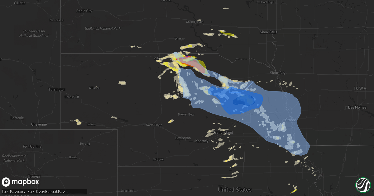
Hail Map in Nebraska on June 23, 2021
Get this storm
June 23 map
$229
one time, instant access
Download today. No call, no setup
Keep the $229
Bought the map and want the full workflow? Apply the entire $229 to a subscription within 7 days. None of it is wasted.
Every map, not just this one
This buys you this map. Subscription and you get every map we run, in the markets you choose from a few cities to whole states to nationwide. Plus real-time alerts the moment a storm fires.
Contact data
Name, contact info, occupancy, even credit band for addresses in the footprint. You go from where it hit to who to call.
Become the source they trust
Unlimited branding weather history reports on demand. You already have the documented answer ready for the property owner, and you are the one who showed up with it.
Property data and RoofTrace estimates
Pull up any address you have got, its value and the exact code rules for that jurisdiction, straight from One Click Code. Then RoofTrace estimates the squares, pitch, and roof value, priced the way you price.
Storm reports in Nebraska
Nebraska
| Date | Description |
|---|---|
| 06/23/20216:41 PM CDT | A local report indicates 1.00 inch wind near JOHNSTOWN |
| 06/23/20215:39 PM CDT | A local report indicates 2.75 inch wind near 3 WSW BURTON |
| 06/23/20216:40 AM CDT | At 1139 PM CDT, severe thunderstorms were located along a line extending from 6 miles south of Newport to 8 miles east of Rose to 8 miles north of Anselmo, moving east at 45 mph. HAZARD...60 mph wind gusts and quarter size hail. SOURCE...Radar indicated. IMPACT...Hail damage to vehicles is expected. Expect wind damage to roofs, siding, and trees. Locations impacted include... O'neill, Burwell, Taylor, Brewster, O'Neill, Atkinson, Stuart, Sargent, Ewing, Chambers, Page, Bartlett, Newport, Ericson, Rose, Amelia, Calamus Reservoir State Recreation Area, Inman, Milburn and Emmet.This includes the following highways... Highway 183 between mile markers 115 and 168. Highway 20 between mile markers 261 and 328. Highway 281 between mile markers 132 and 196. |
| 06/23/20216:27 AM CDT | At 1126 PM CDT, a severe thunderstorm was located near Page, or 15 miles east of O'neill, moving southeast at 25 mph. HAZARD...60 mph wind gusts and half dollar size hail. SOURCE...Radar indicated. IMPACT...Hail damage to vehicles is expected. Expect wind damage to roofs, siding, and trees. This severe thunderstorm will be near... Orchard around 1135 PM CDT. Neligh around 1155 PM CDT. Meadow Grove around 1215 AM CDT.Other locations impacted by this severe thunderstorm include TheHighway 14 And 59 Junction, Royal, Brunswick, Foster, Ashfall FossilBeds State Historical Park and Tilden. |
| 06/23/20216:20 AM CDT | At 1120 PM CDT, severe thunderstorms were located along a line extending from 10 miles north of Brewster to near Dunning, moving east at 40 mph. HAZARD...60 mph wind gusts and quarter size hail. SOURCE...Radar indicated. IMPACT...Hail damage to vehicles is expected. Expect wind damage to roofs, siding, and trees. Locations impacted include... Brewster, Anselmo, Dunning, Victoria Springs State Recreation Area, Milburn, Milburn Diversion Dam State Wildlife Management Area, Linscott, Almeria Meadow State Wildlife Management Area, Horseshoe Bend Lake and Almeria.This includes the following highways... Highway 183 between mile markers 136 and 143. Highway 2 between mile markers 232 and 261. |
| 06/23/20215:57 AM CDT | At 1056 PM CDT, a severe thunderstorm was located near Johnstown, or 9 miles west of Ainsworth, moving east at 45 mph. HAZARD...60 mph wind gusts and quarter size hail. SOURCE...Radar indicated. IMPACT...Hail damage to vehicles is expected. Expect wind damage to roofs, siding, and trees. Locations impacted include... Ainsworth, Bassett, Long Pine, Newport, Johnstown, Rose, Wood Lake, Hofeld Lake, Fox Bayou, Raven, Bobcat State Wildlife Management Area, Twin Lakes State Wildlife Management Area, Willow Lake State Wildlife Management Area, Thomas Creek State Wildlife Management Area, Duff, Mariaville, Pine Glen State Wildlife Refuge, Antelope Peak, Sybrant and Moon Lake.This includes the following highways... Highway 183 between mile markers 145 and 209. Highway 20 between mile markers 216 and 272. |
| 06/23/20215:53 AM CDT | At 1052 PM CDT, a severe thunderstorm was located near O'neill, moving southeast at 35 mph. HAZARD...70 mph wind gusts and half dollar size hail. SOURCE...Radar indicated. IMPACT...Hail damage to vehicles is expected. Expect considerable tree damage. Wind damage is also likely to mobile homes, roofs, and outbuildings. Locations impacted include... O'neill, O'Neill, Ewing, Chambers, Page, Inman, Emmet, Knievels Corner, Cumminsville, Four Corners and Goose Lake State Wildlife Management Area.This includes the following highways... Highway 20 between mile markers 291 and 328. Highway 281 between mile markers 144 and 196. |
| 06/23/20215:27 AM CDT | At 1027 PM CDT, a severe thunderstorm was located over Atkinson, or 14 miles west of O'Neill, moving southeast at 40 mph. HAZARD...Golf ball size hail and 70 mph wind gusts. SOURCE...Radar indicated. IMPACT...People and animals outdoors will be injured. Expect hail damage to roofs, siding, windows, and vehicles. Expect considerable tree damage. Wind damage is also likely to mobile homes, roofs, and outbuildings. Locations impacted include... O'neill, O'Neill, Atkinson, Chambers, Page, Amelia, Inman, Emmet and Opportunity.This includes the following highways... Highway 20 between mile markers 281 and 325. Highway 281 between mile markers 155 and 197. |
| 06/23/20215:25 AM CDT | At 1025 PM CDT, a severe thunderstorm was located over Ainsworth, moving southeast at 40 mph. HAZARD...60 mph wind gusts and half dollar size hail. SOURCE...Radar indicated. IMPACT...Hail damage to vehicles is expected. Expect wind damage to roofs, siding, and trees. Locations impacted include... Ainsworth, Bassett, Long Pine, Newport, Johnstown, Wood Lake, Hofeld Lake, Raven, Bobcat State Wildlife Management Area, Meadville, North River Trail, Keller Park State Recreation Area, Pine Glen State Wildlife Refuge, Antelope Peak, Jones Lake and Johnsons Corner.This includes the following highways... Highway 183 between mile markers 169 and 207. Highway 20 between mile markers 219 and 271. |
| 06/23/20214:50 AM CDT | At 950 PM CDT, a severe thunderstorm was located 8 miles southeast of Norden, or 13 miles west of Springview, moving southeast at 30 mph. HAZARD...Ping pong ball size hail and 60 mph wind gusts. SOURCE...Radar indicated. IMPACT...People and animals outdoors will be injured. Expect hail damage to roofs, siding, windows, and vehicles. Expect wind damage to roofs, siding, and trees. Locations impacted include... Ainsworth, Springview, Keller Park State Recreation Area, Thomas Creek State Wildlife Management Area, Bobcat State Wildlife Management Area, Pine Glen State Wildlife Refuge, Antelope Peak, Meadville and North River Trail.This includes the following highways... Highway 183 between mile markers 200 and 215. Highway 20 between mile markers 238 and 243. Highway 12 between mile markers 31 and 51. |
| 06/23/20214:07 AM CDT | At 907 PM CDT, a severe thunderstorm was located near Springview, moving southeast at 30 mph. HAZARD...60 mph wind gusts and quarter size hail. SOURCE...Radar indicated. IMPACT...Hail damage to vehicles is expected. Expect wind damage to roofs, siding, and trees. Locations impacted include... Bassett, Newport, Keller Park State Recreation Area, Thomas Creek State Wildlife Management Area, Mariaville, Bobcat State Wildlife Management Area, Pine Glen State Wildlife Refuge and Meadville.This includes the following highways... Highway 183 between mile markers 177 and 182, and between milemarkers 199 and 212. Highway 20 between mile markers 254 and 271. |
| 06/23/20213:39 AM CDT | Report from mping: quarter |
| 06/23/20213:22 AM CDT | Asos station koma omaha eppley airfield. |
| 06/23/20213:20 AM CDT | Large diameter tree broken at the trunk and laying across road on harney st. |
| 06/23/20213:20 AM CDT | At 820 PM CDT, severe thunderstorms were located along a line extending from near Milltown to near Springfield, moving east at 50 mph. HAZARD...60 mph wind gusts. SOURCE...Radar indicated. IMPACT...Expect damage to roofs, siding, and trees. Severe thunderstorms will be near... Springfield around 825 PM CDT. Clayton around 830 PM CDT. Freeman and Dolton around 845 PM CDT. Marion around 850 PM CDT.Other locations impacted by these severe thunderstorms includeGayville, Lesterville, Olivet and Yankton Sioux Tribal Nation. |
| 06/23/20213:14 AM CDT | A local report indicates 58 MPH wind near TEKAMAH |
| 06/23/20213:12 AM CDT | Measured on personal weather station. |
| 06/23/20213:12 AM CDT | At 811 PM CDT, a severe thunderstorm was located 10 miles east of Valentine, moving east at 20 mph. HAZARD...60 mph wind gusts and quarter size hail. SOURCE...Radar indicated. IMPACT...Hail damage to vehicles is expected. Expect wind damage to roofs, siding, and trees. Locations impacted include... Sparks and Smith Falls State Park. This includes the following highways... Highway 20 between mile markers 203 and 206. Highway 12 between mile markers 3 and 26. |
| 06/23/20213:12 AM CDT | Significant tree damage about 34th and harney area. Tree in the road. Report time based on radar. |
| 06/23/20213:10 AM CDT | Photo submitted via social media of a large tree down on a residential home causing roof damage. |
| 06/23/20213:04 AM CDT | At 804 PM CDT, a severe thunderstorm was located 7 miles south of Millboro, or 13 miles northwest of Springview, moving east at 25 mph. HAZARD...60 mph wind gusts and quarter size hail. SOURCE...Radar indicated. IMPACT...Hail damage to vehicles is expected. Expect wind damage to roofs, siding, and trees. Locations impacted include... Springview, Norden, Burton, Nets Peak, Thomas Creek State Wildlife Management Area and North River Trail.This includes the following highways... Highway 183 between mile markers 209 and 225. Highway 12 between mile markers 27 and 70. |
| 06/23/20213:00 AM CDT | A local report indicates 60 MPH wind near 2 NNE LESHARA |
| 06/23/20213:00 AM CDT | Large tree branch down. Report and accompanying picture received via social media. Report time based on radar. |
| 06/23/20212:59 AM CDT | Tree snapped off in back yard. Report time based on radar. |
| 06/23/20212:56 AM CDT | Measured on personal weather station. |
| 06/23/20212:50 AM CDT | Measured on personal weather station. |
| 06/23/20212:44 AM CDT | Trees snapped off at the top and large limbs down. |
| 06/23/20212:37 AM CDT | Report from mping: 3-inch tree limbs broken; power poles broken. |
| 06/23/20212:30 AM CDT | Powerlines down. |
| 06/23/20212:25 AM CDT | Kfet gust to 51 kt. |
| 06/23/20212:20 AM CDT | Measured on personal weather station. |
| 06/23/20212:20 AM CDT | A local report indicates 60 MPH wind near 2 NW WINSLOW |
| 06/23/20212:15 AM CDT | Power is out. |
| 06/23/20212:13 AM CDT | Powerlines down. |
| 06/23/20212:10 AM CDT | Major power lines down. Road closed. Time estimated from radar. |
| 06/23/20212:05 AM CDT | Numerous large trees down throughout town. |
| 06/23/20212:02 AM CDT | Several large trees down. |
| 06/23/20212:02 AM CDT | Multiple trees and large branches down in town. Report and pictures received via social media. Report time based on radar. |
| 06/23/20212:00 AM CDT | Several trees and powerlines down. |
| 06/23/20212:00 AM CDT | Measured on personal weather station. |
| 06/23/20212:00 AM CDT | Power outages. |
| 06/23/20211:59 AM CDT | Multiple large tree branches down. Report time based on radar. |
| 06/23/20211:55 AM CDT | A local report indicates 71 MPH wind near HOWELLS |
| 06/23/20211:48 AM CDT | Report of a modular home roof being blown off. Time estimated based on columbus airport peak gust. |
| 06/23/20211:48 AM CDT | Numerous trees and large branches down in columbus. |
| 06/23/20211:48 AM CDT | A local report indicates 61 MPH wind near COLUMBUS |
| 06/23/20211:45 AM CDT | At 644 PM CDT, a severe thunderstorm was located near Johnstown, moving southeast at 35 mph. HAZARD...Ping pong ball size hail and 60 mph wind gusts. SOURCE...Radar indicated. IMPACT...People and animals outdoors will be injured. Expect hail damage to roofs, siding, windows, and vehicles. Expect wind damage to roofs, siding, and trees. Locations impacted include... Ainsworth, Long Pine, Johnstown, Hofeld Lake, Duff, Jones Lake and Twin Lakes State Wildlife Management Area.This includes the following highways... Highway 183 between mile markers 161 and 180, and between milemarkers 194 and 198. Highway 20 between mile markers 231 and 256. |
| 06/23/20211:37 AM CDT | Power outage. |
| 06/23/20211:33 AM CDT | A local report indicates 60 MPH wind near NORFOLK |
| 06/23/20211:32 AM CDT | 3 to 4-ft diameter trees knocked over... Downing powerlines. Report time based on radar. |
| 06/23/20211:21 AM CDT | Several large trees down. |
| 06/23/20211:20 AM CDT | Photo showing farm outbuilding with partial roof removal. Several large trees were also reported down in the area. |
| 06/23/20211:19 AM CDT | A local report indicates 64 MPH wind near 8 NNE PALMER |
| 06/23/20211:05 AM CDT | At 604 PM CDT, a severe thunderstorm was located 12 miles southwest of Naper, or 22 miles east of Springview, moving east at 40 mph. HAZARD...60 mph wind gusts and quarter size hail. SOURCE...Radar indicated. IMPACT...Hail damage to vehicles is expected. Expect wind damage to roofs, siding, and trees. Locations impacted include... Butte, Naper, Dustin, Anoka, Mills, Brocksburg, Parshall Bridge State Wildlife Management Area and Hull Lake State Wildlife Management Area.This includes Highway 12 between mile markers 76 and 119. |
| 06/23/20211:05 AM CDT | Measured on personal weather station. |
| 06/23/20211:00 AM CDT | Measured on personal weather station. |
| 06/23/20211:00 AM CDT | Several trees down. |
| 06/23/202112:59 AM CDT | At 559 PM CDT, a severe thunderstorm was located 13 miles southwest of Norden, or 19 miles southeast of Valentine, moving southeast at 15 mph. HAZARD...Golf ball size hail and 60 mph wind gusts. SOURCE...Radar indicated. IMPACT...People and animals outdoors will be injured. Expect hail damage to roofs, siding, windows, and vehicles. Expect wind damage to roofs, siding, and trees. Locations impacted include... Johnstown, Wood Lake and Antelope Peak. This includes Highway 20 between mile markers 214 and 237. |
| 06/23/202112:58 AM CDT | At 557 PM CDT, a severe thunderstorm was located 8 miles south of Springview, moving southeast at 15 mph. HAZARD...Ping pong ball size hail and 60 mph wind gusts. SOURCE...Radar indicated. IMPACT...People and animals outdoors will be injured. Expect hail damage to roofs, siding, windows, and vehicles. Expect wind damage to roofs, siding, and trees. Locations impacted include... Bassett, Long Pine, Keller Park State Recreation Area, Thomas Creek State Wildlife Management Area and Pine Glen State Wildlife Refuge.This includes the following highways... Highway 183 between mile markers 173 and 182, and between milemarkers 196 and 212. Highway 20 between mile markers 250 and 264. |
| 06/23/202112:57 AM CDT | Deputy estimated 60 mph winds...had to remove branch blocking part of highway 22. |
| 06/23/202112:55 AM CDT | Awos station kbvn albion airport. |
| 06/23/202112:48 AM CDT | Delayed report of extensive damage to trees and branches around greeley. Some up to 2 ft in diameter. Time estimated from radar. |
| 06/23/202112:45 AM CDT | Several trees and branches down... Campers damaged. |
| 06/23/202112:45 AM CDT | An open faced cattle shed was destroyed. Wind estimated at 70 mph. |
| 06/23/202112:35 AM CDT | A local report indicates 85 MPH wind near 1 NW NELIGH |
| 06/23/202112:35 AM CDT | Facebook photo of tree at least 1 foot in diameter snapped over. Time estimated from radar. Relayed by dispatch in albion. |
| 06/23/202112:29 AM CDT | Measured by a mesonet on the west side of ord. |
| 06/23/202112:25 AM CDT | A local report indicates 69 MPH wind near ORD AIRPORT |
| 06/23/202112:22 AM CDT | At 521 PM CDT, a severe thunderstorm was located near Valentine, moving east at 15 mph. HAZARD...60 mph wind gusts and half dollar size hail. SOURCE...Radar indicated. IMPACT...Hail damage to vehicles is expected. Expect wind damage to roofs, siding, and trees. Locations impacted include... Valentine, Wood Lake, Highway 97 crossing the Niobrara River and Schlagel Creek State Wildlife Management Area.This includes the following highways... Highway 20 between mile markers 193 and 222. Highway 97 between mile markers 135 and 141. Highway 83 between mile markers 200 and 216. Highway 12 between mile markers 1 and 4. |
| 06/23/202112:15 AM CDT | Multiple reports of trees down in town. Unknown size at this time. |
| 06/22/202111:35 PM CDT | A local report indicates 60 MPH wind near 2 S BREWSTER |
| 06/22/202111:30 PM CDT | Large cottonwood branch... 20 inches in diameter... Downed in wind. Time estimated by radar. |
| 06/22/202111:24 PM CDT | Via personal weather station |
| 06/22/202110:55 PM CDT | Konl awos |
| 06/22/202110:32 PM CDT | A local report indicates 1.75 inch wind near 5 WNW AINSWORTH |
| 06/22/202110:28 PM CDT | A local report indicates 60 MPH wind near 3 SSW ATKINSON |
| 06/22/202110:00 PM CDT | A local report indicates 1.50 inch wind near 9 NNE NEWPORT |
| 06/22/20219:15 PM CDT | A local report indicates 1.00 inch wind near 3 SE SPRINGVIEW |
| 06/22/20219:10 PM CDT | A local report indicates 1.75 inch wind near 2 W SPRINGVIEW |
| 06/22/20218:32 PM CDT | A local report indicates 1.00 inch wind near 6 N SPRINGVIEW |
All States Impacted by Hail Map on June 23, 2021
Cities Impacted by Hail Map on June 23, 2021
- Saint Paul, NE
- Wood Lake, NE
- Edgar, NE
- Nelson, NE
- Superior, NE
- Gothenburg, NE
- Brady, NE
- Callaway, NE
- Delia, KS
- Mayetta, KS
- Gretna, NE
- Springfield, NE
- Ashland, NE
- South Bend, NE
- Omaha, NE
- Hayward, WI
- Ravenna, NE
- Burwell, NE
- Clearwater, NE
- Keshena, WI
- Worden, MT
- Shepherd, MT
- Parkston, SD
- Dimock, SD
- Hardy, NE
- Hinckley, MN
- Schofield, WI
- Cornucopia, WI
- Bayfield, WI
- Burlington, CO
- Mills, NE
- Springview, NE
- Giltner, NE
- Valentine, NE
- Cotton, MN
- Burke, SD
- Randolph, NE
- Pierce, NE
- Spalding, NE
- Greeley, NE
- Ericson, NE
- Scotia, NE
- Long Pine, NE
- Bassett, NE
- Atkinson, NE
- Winner, SD
- Johnstown, NE
- Sparks, NE
- Newport, NE
- Stuart, NE
- Ainsworth, NE
- Elgin, NE
- Amelia, NE
- Chambers, NE
- Bartlett, NE
- Falls City, NE
- Colome, SD
- Alexander, KS
- Elgin, OR
- Duluth, MN
- Mount Vernon, SD
- Stickney, SD
- Ashby, NE
- Merriman, NE
- Phillips, WI
- Fifield, WI
- Page, NE
- Ewing, NE
- Orchard, NE
- Royal, NE
- Neligh, NE
- Inman, NE
- Shell Lake, WI
- Siren, WI
- Frederic, WI
- Webster, WI
- Arapahoe, CO
- Mankato, KS
- Hibbing, MN
- Ness City, KS
- Bazine, KS
- Ogallah, KS
- Wakeeney, KS
- Ellis, KS
- Cecil, WI
- Stratton, CO
- Columbus, NE
- Schuyler, NE
- Red Level, AL
- Andalusia, AL
- Bend, OR
- Madison, NE
- Albion, NE
- Troy, KS
- Wathena, KS
- Danbury, WI
- Wausau, WI
- Sandstone, MN
- Lewellen, NE
- Harvard, NE
- Esko, MN
- Cloquet, MN
- Dix, NE
- Potter, NE
- Petersburg, NE
- Dallas, SD
- Kimball, NE
- Aurora, NE
- Phillips, NE
- Unadilla, NE
- Palmyra, NE
- Lincoln, NE
- Eagle, NE
- Walton, NE
- Elmwood, NE
- Bennet, NE
- Brewster, NE
- Taylor, NE
- Grantsburg, WI
- Weeping Water, NE
- Avoca, NE
- Talmage, NE
- Lublin, WI
- Elgin, AZ
- Sonoita, AZ
- Rice Lake, WI
- Palco, KS
- Makinen, MN
- Cameron, WI
- Weyerhaeuser, WI
- Bruce, WI
- Chetek, WI
- Cairo, NE
- Wood River, NE
- Doniphan, NE
- Platte, SD
- Mosinee, WI
- Lavina, MT
- Two Harbors, MN
- Clay Center, NE
- Shawano, WI
- White Lake, SD
- Kimball, SD
- Hornick, IA
- Sloan, IA
- Whiting, IA
- Shelton, NE
- Gregory, SD
- Clarkson, NE
- Chisholm, MN
- Purdum, NE
- Dunning, NE
- Truxton, MO
- Lake Nebagamon, WI
- Belleville, KS
- Webber, KS
- Scandia, KS
- Courtland, KS
- Formoso, KS
- Jewell, KS
- Grand Island, NE
- Nebraska City, NE
- Percival, IA
- Nashwauk, MN
- Silver Creek, NE
- Roseland, NE
- Juniata, NE
- Crossroads, NM
- Solon Springs, WI
- Castana, IA
- Rodney, IA
- Smithland, IA
- Holton, KS
- Tuthill, SD
- Hertel, WI
- Gordon, WI
- Minong, WI
- Waterloo, NE
- Murdock, NE
- Yutan, NE
- Greenwood, NE
- Waverly, NE
- Cedar Creek, NE
- Wahoo, NE
- Ceresco, NE
- Mead, NE
- Memphis, NE
- Ithaca, NE
- Louisville, NE
- Kenesaw, NE
- Table Rock, NE
- Pawnee City, NE
- Merrill, WI
- Cumberland, WI
- Gilman, WI
- Holcombe, WI
- Withee, WI
- Thorp, WI
- Terrebonne, OR
- Redmond, OR
- McCracken, KS
- Hays, KS
- Schoenchen, KS
- Emmet, NE
- Wayne, NE
- Raymond, NE
- Davey, NE
- Bethune, CO
- Auburn, NE
- Brownville, NE
- Plattsmouth, NE
- Oregon, MO
- Forest City, MO
- Baldwin City, KS
- Lawrence, KS
- Rogers, NE
- Morse Bluff, NE
- Malmo, NE
- North Bend, NE
- Weston, NE
- Howells, NE
- Dodge, NE
- David City, NE
- Prague, NE
- Linwood, NE
- Saint Edward, NE
- Fullerton, NE
- Genoa, NE
- White Cloud, KS
- Highland, KS
- Robinson, KS
- Junction City, WI
- Healy, KS
- Dighton, KS
- Osmond, NE
- Brunswick, NE
- Plainview, NE
- Farwell, NE
- Dannebrog, NE
- Western, NE
- Dorchester, NE
- Crete, NE
- Wilber, NE
- Cable, WI
- Hatley, WI
- Butternut, WI
- Park Falls, WI
- Plainville, KS
- Brimson, MN
- Valparaiso, NE
- Douglas, NE
- Rib Lake, WI
- Medford, WI
- Athens, WI
- Colon, NE
- Norfolk, NE
- Humphrey, NE
- Lindsay, NE
- Leigh, NE
- Monroe, NE
- Meadow Grove, NE
- Oakdale, NE
- Creston, NE
- Battle Creek, NE
- Stanton, NE
- Tilden, NE
- Newman Grove, NE
- Central City, NE
- Hawk Point, MO
- Bellflower, MO
- Tucson, AZ
- Green Valley, AZ
- Weskan, KS
- Oak, NE
- Corsica, SD
- Eveleth, MN
- Circleville, KS
- Scott City, KS
- Herbster, WI
- Craig, MO
- Fairfax, MO
- Brookston, MN
- Carleton, NE
- Ruskin, NE
- Trego, WI
- Antigo, WI
- Emerson, NE
- Montgomery City, MO
- Middletown, MO
- Floodwood, MN
- Catawba, WI
- Evergreen, AL
- Brewton, AL
- Sargent, NE
- Clayton, KS
- Lenora, KS
- Brainard, NE
- Dwight, NE
- Brook Park, MN
- Trumbull, NE
- Hastings, NE
- Sterling, NE
- Burr, NE
- Hebron, NE
- Rulo, NE
- Verdon, NE
- Gibbon, NE
- Woonsocket, SD
- Mapleton, IA
- Burdett, KS
- McCool Junction, NE
- Luck, WI
- Fairfield, NE
- Oneill, NE
- Kearney, NE
- New Auburn, WI
- Guide Rock, NE
- Alexandria, SD
- Maple, WI
- Rock Port, MO
- Hamburg, IA
- Saint Cloud, MN
- Naper, NE
- Nemaha, NE
- Peru, NE
- Wittenberg, WI
- Roundup, MT
- Barronett, WI
- Halsey, NE
- Johnson, NE
- Tecumseh, NE
- Overbrook, KS
- Syracuse, NE
- Dunbar, NE
- Cook, NE
- Otoe, NE
- Lorton, NE
- Union, NE
- Brock, NE
- Murray, NE
- Nehawka, NE
- Julian, NE
- Grafton, NE
- Geneva, NE
- Forbes, MN
- Iron, MN
- Arivaca, AZ
- Monument, KS
- Soldier, KS
- Havensville, KS
- Sutton, NE
- Deshler, NE
- Eudora, KS
- Mountain Iron, MN
- Murphy, ID
- Castleberry, AL
- Keewatin, MN
- Friend, NE
- Pukwana, SD
- Labelle, FL
- Bonduel, WI
- Elyria, NE
- Sarona, WI
- Barron, WI
- Comstock, WI
- Gillett, WI
- Moore, ID
- Eland, WI
- Hoskins, NE
- Marathon, WI
- Birnamwood, WI
- Rosholt, WI
- Ringle, WI
- Rothschild, WI
- Thedford, NE
- Chapman, NE
- Alliance, NE
- Hordville, NE
- Seney, MI
- Salem, NE
- Dawson, NE
- Ute, IA
- Holstein, NE
- Saronville, NE
- Tigerton, WI
- Pep, NM
- Carroll, NE
- Portsmouth, IA
- Belgrade, NE
- Platte Center, NE
- Malcolm, NE
- Fort Calhoun, NE
- Winside, NE
- Staplehurst, NE
- Adams, NE
- Surprise, NE
- Pilger, NE
- Stromsburg, NE
- Mondamin, IA
- Kennard, NE
- Logan, IA
- Boys Town, NE
- Wisner, NE
- Gresham, NE
- Decatur, NE
- Tekamah, NE
- Tabor, IA
- Bennington, NE
- Bellwood, NE
- Uehling, NE
- Hickman, NE
- Pacific Junction, IA
- Crescent, IA
- Cedar Bluffs, NE
- Martell, NE
- Lyons, NE
- Primrose, NE
- Ulysses, NE
- Bruno, NE
- Moorhead, IA
- Abie, NE
- Garland, NE
- West Point, NE
- Elkhorn, NE
- Seward, NE
- Osceola, NE
- North Loup, NE
- Blencoe, IA
- Denton, NE
- Glenwood, IA
- Randolph, IA
- Blair, NE
- Cedar Rapids, NE
- Bee, NE
- Wolbach, NE
- Malvern, IA
- Persia, IA
- Little Sioux, IA
- Arlington, NE
- Ord, NE
- Rising City, NE
- Winslow, NE
- Milford, NE
- Sidney, IA
- Beemer, NE
- Minden, IA
- Carter Lake, IA
- Pleasant Dale, NE
- Clarks, NE
- Pender, NE
- Duncan, NE
- Honey Creek, IA
- Palmer, NE
- Snyder, NE
- Pisgah, IA
- Shelby, NE
- Woodbine, IA
- Dunlap, IA
- Modale, IA
- Watson, MO
- Onawa, IA
- Farragut, IA
- Thurman, IA
- Bellevue, NE
- Nickerson, NE
- Washington, NE
- Bancroft, NE
- Underwood, IA
- Shenandoah, IA
- Westboro, MO
- Missouri Valley, IA
- Broken Bow, NE
- Riverton, IA
- McClelland, IA
- Tarkio, MO
- La Vista, NE
- Ames, NE
- Blanchard, IA
- Valley, NE
- Neola, IA
- Roca, NE
- Manley, NE
- Herman, NE
- Hooper, NE
- Fremont, NE
- Council Bluffs, IA
- Coin, IA
- Alvo, NE
- Oakland, NE
- Scribner, NE
- Northboro, IA
- Papillion, NE
- Craig, NE
- Comstock, NE
- Magnolia, IA
- Offutt Afb, NE
- Ethan, SD


