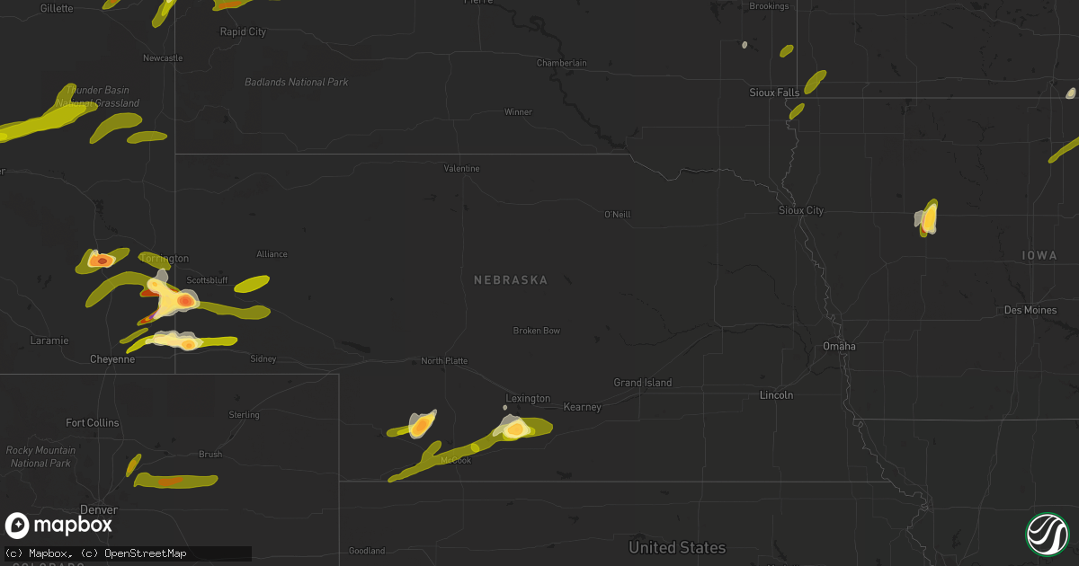
Hail Map in Nebraska on June 22, 2013
Get this storm
June 22 map
$229
one time, instant access
Download today. No call, no setup
Keep the $229
Bought the map and want the full workflow? Apply the entire $229 to a subscription within 7 days. None of it is wasted.
Every map, not just this one
This buys you this map. Subscription and you get every map we run, in the markets you choose from a few cities to whole states to nationwide. Plus real-time alerts the moment a storm fires.
Contact data
Name, contact info, occupancy, even credit band for addresses in the footprint. You go from where it hit to who to call.
Become the source they trust
Unlimited branding weather history reports on demand. You already have the documented answer ready for the property owner, and you are the one who showed up with it.
Property data and RoofTrace estimates
Pull up any address you have got, its value and the exact code rules for that jurisdiction, straight from One Click Code. Then RoofTrace estimates the squares, pitch, and roof value, priced the way you price.
Storm reports in Nebraska
Nebraska
| Date | Description |
|---|---|
| 06/22/20136:30 PM CDT | Thunderstorm winds severely damaged a wheat crop in a 2 to 3 mile wide path...from 14 miles northwest of harrisburg to 7 miles east of that location. |
| 06/22/20136:26 PM CDT | Tornado visible between 526 and 532 pm mdt. Tornado dissipated shortly thereafter. Report from off duty spc forecaster. |
| 06/22/20136:10 PM CDT | Hail mostly quarter sized with some to size of tennis balls. Heavy rain with vis down to 1/8 mi. 2 windows damaged. One cracked. One broken out. Both on north side of h |
| 06/22/20136:04 PM CDT | Center pivot partially overturned. |
| 06/22/20136:00 PM CDT | Tornado produced damage at a house 7 miles north and 14 miles west of harrisburg...about 2.5 miles east of the wyoming state line. A house at that location received con |
| 06/22/20135:51 PM CDT | Tornado visible between 451 and 456 pm mdt. Report from off duty spc forecaster. |
| 06/22/20135:50 PM CDT | Nws damage survey confirmed ef-1 tornado damage in northwest banner county on june 22nd. Tornado developed 17 wnw harrisburg at about 450 pm and tracked ese before diss |
| 06/22/20131:30 AM CDT | A local report indicates 59 MPH wind near 9 NNE LEXINGTON |
| 06/22/20131:19 AM CDT | Downed power line with adjacent tree on fire. One inch hail also being reported. |
| 06/22/20131:08 AM CDT | Deputy sheriff reports 1 inch hail and heavy rain. |
| 06/22/20131:08 AM CDT | Deputy sheriff reports 1 inch hail and heavy rain. |
| 06/22/20131:00 AM CDT | Delayed report...from about 4 miles west of highway 283 to about 3 miles east of highway 283...crop damage was discovered about 2 miles north of the gosper/furnas count |
| 06/22/20131:00 AM CDT | Golf ball hail coming down sideways. Estimated 80 mph winds. |
| 06/22/201312:57 AM CDT | A local report indicates 60 MPH wind near 1 ESE EWING |
| 06/22/201312:56 AM CDT | Quarter size hail and winds estimated at 60 to 70 mph on hiway 283 near mile marker 30. |
| 06/22/201312:55 AM CDT | Power outage reported by local law enforcement. |
| 06/22/201312:30 AM CDT | The combination of wind and hail stripped some corn in the field. Hail was estimated at dime size and wind gusts were over 50 mph. |
| 06/22/201312:30 AM CDT | Power outage reported by local law enforcement. |
| 06/22/201312:23 AM CDT | 67 mph wind gust measured with automated equipment at ord airport. |
| 06/22/201312:15 AM CDT | A large limb... Approx 4 inches in diameter... Broke off. Time is estimated off radar. |
| 06/22/201312:15 AM CDT | Power outage reported by local law enforcement. |
| 06/22/201312:12 AM CDT | Via social media |
| 06/22/201312:00 AM CDT | A local report indicates 1.00 inch wind near 3 WNW MCCOOK |
| 06/21/201311:35 PM CDT | Thunderstorm wind gust measured at 58 mph. |
| 06/21/201311:30 PM CDT | Time estimated based on radar |
| 06/21/201311:30 PM CDT | An apparent micro-burst overturned a pivot irrigator and left nearby pivots unaffected. |
| 06/21/201311:21 PM CDT | Delayed report. Multiple trees and power lines down in mullen. |
| 06/21/201311:15 PM CDT | Wind gust of 60 mph measured by the thomas county airport asos. |
| 06/21/201310:58 PM CDT | Power is out in mullen...street signs have been knocked down. Wind estimated by law enforcement at 70 mph. |
| 06/21/201310:56 PM CDT | A local report indicates 60 MPH wind near MULLEN |
| 06/21/201310:55 PM CDT | Wind gust of 67 mph recorded by the north platte airport asos. |
| 06/21/201310:50 PM CDT | A local report indicates 1.75 inch wind near 1 N HAYES CENTER |
| 06/21/201310:45 PM CDT | A local report indicates 2.75 inch wind near 2 W HAYES CENTER |
| 06/21/20139:35 PM CDT | A local report indicates 1.00 inch wind near MAYWOOD |
| 06/21/20137:59 PM CDT | Tornado lifted at 702 pm. |
| 06/21/20137:58 PM CDT | Tornado was on interstate 80. |
| 06/21/20137:26 PM CDT | A local report indicates 1.00 inch wind near 4 WSW REDINGTON |
| 06/21/20137:19 PM CDT | Reported at bushnell and at oliver lake. |
| 06/21/20137:08 PM CDT | A local report indicates 1.00 inch wind near 4 W OLIVER RESERVOIR |
| 06/21/20137:03 PM CDT | 50 to 60 mph wind gusts and nickel sized hail at the intersection of stonegate and highland roads. |
All States Impacted by Hail Map on June 22, 2013
Cities Impacted by Hail Map on June 22, 2013
- Lytton, IA
- Latham, IL
- Warrensburg, IL
- New Leipzig, ND
- Elgin, ND
- Arapahoe, NE
- Elwood, NE
- Eustis, NE
- Casper, WY
- Harrisburg, NE
- Lyman, NE
- Yoder, WY
- Lagrange, WY
- Hawk Springs, WY
- Jolley, IA
- Rockwell City, IA
- Pomeroy, IA
- Lake View, IA
- Lake City, IA
- Fonda, IA
- Sac City, IA
- Auburn, IA
- Holbrook, NE
- Bertrand, NE
- Cheyenne, WY
- Meriden, WY
- Belle Fourche, SD
- Spearfish, SD
- Gering, NE
- Torrington, WY
- Albin, WY
- Wheatland, WY
- Leoti, KS
- Rugby, ND
- Hayes Center, NE
- Palisade, NE
- London, OH
- Steele, ND
- Bismarck, ND
- Bushnell, NE
- Burns, WY
- Pine Bluffs, WY
- Wauneta, NE
- Saint Onge, SD
- Beulah, WY
- Whitewood, SD
- Sundance, WY
- Madison, SD
- Glenville, MN
- Austin, MN
- Lyle, MN
- Northwood, IA
- Lead, SD
- Carson, ND
- McCook, NE
- Kimball, NE
- Culbertson, NE
- Linton, ND
- Tribune, KS
- Max, NE
- Trenton, NE
- Stratton, NE
- Bartley, NE
- Stockville, NE
- Benkelman, NE
- Bird City, KS
- Indianola, NE
- Bridgeport, NE
- Chugwater, WY
- Bayard, NE
- Broadwater, NE
- Potter, NE
- Dix, NE
- Lingle, WY
- Veteran, WY
- Angora, NE
- Guernsey, WY
- Glenrock, WY
- Douglas, WY
- Lander, WY
- Shoshoni, WY
- Jeffrey City, WY
- Gillette, WY
- Bennett, CO
- Brush, CO
- Byers, CO
- Woodrow, CO
- Wiggins, CO
- Hudson, CO
- Keenesburg, CO
- Roggen, CO
- Fort Morgan, CO
- Strasburg, CO
- La Salle, CO
- Kersey, CO
- Hettinger, ND
- Lemmon, SD
- Sturgis, SD
- New Underwood, SD
- Piedmont, SD
- Lance Creek, WY
- Newell, SD
- Aladdin, WY
- Vale, SD
- Devils Tower, WY
- Moorcroft, WY
- Osage, WY
- Newcastle, WY
- Lusk, WY
- Meadow, SD
- Bison, SD
- Mud Butte, SD
- Faith, SD
- Prairie City, SD
- Loomis, NE
- Moorefield, NE
- Holdrege, NE
- Cambridge, NE
- Smithfield, NE
- Selfridge, ND
- Solen, ND
- Fort Yates, ND
- Mandan, ND
- Kintyre, ND
- Driscoll, ND
- Dawson, ND
- Osage, IA
- Thornton, IA
- Rockwell, IA
- Rudd, IA
- Nora Springs, IA
- Rockford, IA
- Swaledale, IA
- Floyd, IA
- Mason City, IA
- Sheffield, IA
- Canton, SD
- Larchwood, IA
- Inwood, IA
- Steen, MN
- Hills, MN
- Beaver Creek, MN
- Magnolia, MN
- Luverne, MN
- Trent, SD
- Dell Rapids, SD
- Flandreau, SD


