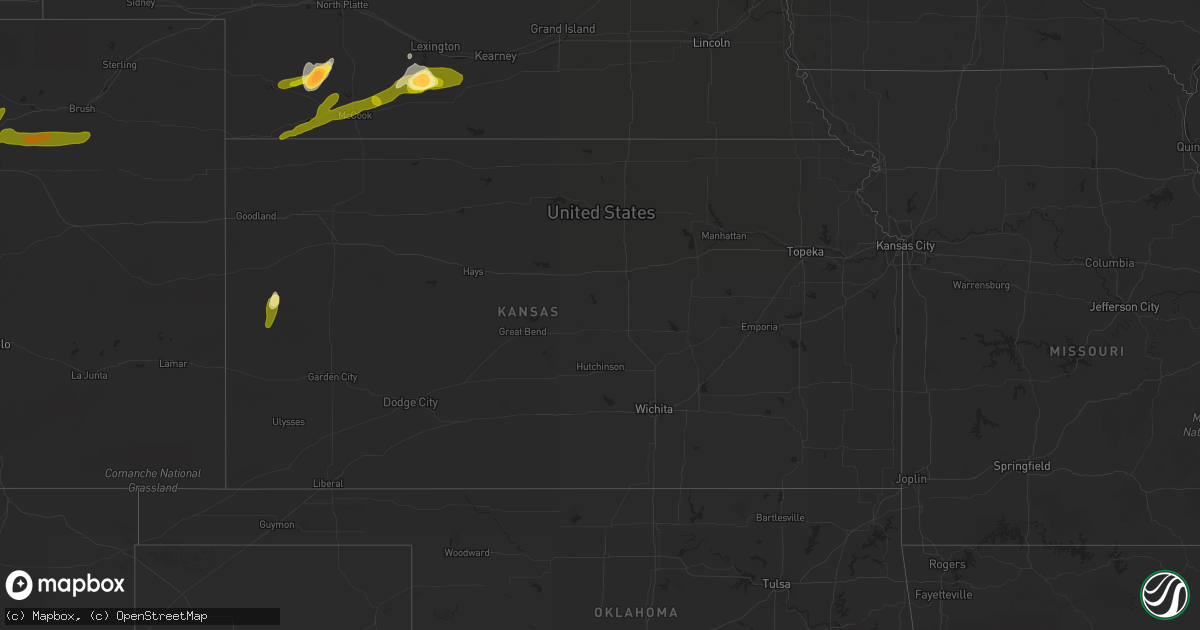
Hail Map in Kansas on June 22, 2013
Get this storm
June 22 map
$229
one time, instant access
Download today. No call, no setup
Keep the $229
Bought the map and want the full workflow? Apply the entire $229 to a subscription within 7 days. None of it is wasted.
Every map, not just this one
This buys you this map. Subscription and you get every map we run, in the markets you choose from a few cities to whole states to nationwide. Plus real-time alerts the moment a storm fires.
Contact data
Name, contact info, occupancy, even credit band for addresses in the footprint. You go from where it hit to who to call.
Become the source they trust
Unlimited branding weather history reports on demand. You already have the documented answer ready for the property owner, and you are the one who showed up with it.
Property data and RoofTrace estimates
Pull up any address you have got, its value and the exact code rules for that jurisdiction, straight from One Click Code. Then RoofTrace estimates the squares, pitch, and roof value, priced the way you price.
Storm reports in Kansas
Kansas
| Date | Description |
|---|---|
| 06/22/20136:53 PM CDT | Measured quarter size hail and some was larger. Estimated to half dollar size. |
| 06/22/20136:52 PM CDT | Nickel to quarter size hail. Started hailing 10 minutes ago. |
| 06/22/20136:52 PM CDT | Nickel to quarter size hail. Started hailing 10 minutes ago. |
| 06/22/20138:33 AM CDT | Most of the hail was pea to dime but 1 stone was the size of a quarter. |
| 06/21/20138:25 PM CDT | Mesonet measured 70 mph wind gust |
| 06/21/20137:15 PM CDT | Quarter size hail off and on for the past 30 minutes. |
All States Impacted by Hail Map on June 22, 2013
Cities Impacted by Hail Map on June 22, 2013
- Lytton, IA
- Latham, IL
- Warrensburg, IL
- New Leipzig, ND
- Elgin, ND
- Arapahoe, NE
- Elwood, NE
- Eustis, NE
- Casper, WY
- Harrisburg, NE
- Lyman, NE
- Yoder, WY
- Lagrange, WY
- Hawk Springs, WY
- Jolley, IA
- Rockwell City, IA
- Pomeroy, IA
- Lake View, IA
- Lake City, IA
- Fonda, IA
- Sac City, IA
- Auburn, IA
- Holbrook, NE
- Bertrand, NE
- Cheyenne, WY
- Meriden, WY
- Belle Fourche, SD
- Spearfish, SD
- Gering, NE
- Torrington, WY
- Albin, WY
- Wheatland, WY
- Leoti, KS
- Rugby, ND
- Hayes Center, NE
- Palisade, NE
- London, OH
- Steele, ND
- Bismarck, ND
- Bushnell, NE
- Burns, WY
- Pine Bluffs, WY
- Wauneta, NE
- Saint Onge, SD
- Beulah, WY
- Whitewood, SD
- Sundance, WY
- Madison, SD
- Glenville, MN
- Austin, MN
- Lyle, MN
- Northwood, IA
- Lead, SD
- Carson, ND
- McCook, NE
- Kimball, NE
- Culbertson, NE
- Linton, ND
- Tribune, KS
- Max, NE
- Trenton, NE
- Stratton, NE
- Bartley, NE
- Stockville, NE
- Benkelman, NE
- Bird City, KS
- Indianola, NE
- Bridgeport, NE
- Chugwater, WY
- Bayard, NE
- Broadwater, NE
- Potter, NE
- Dix, NE
- Lingle, WY
- Veteran, WY
- Angora, NE
- Guernsey, WY
- Glenrock, WY
- Douglas, WY
- Lander, WY
- Shoshoni, WY
- Jeffrey City, WY
- Gillette, WY
- Bennett, CO
- Brush, CO
- Byers, CO
- Woodrow, CO
- Wiggins, CO
- Hudson, CO
- Keenesburg, CO
- Roggen, CO
- Fort Morgan, CO
- Strasburg, CO
- La Salle, CO
- Kersey, CO
- Hettinger, ND
- Lemmon, SD
- Sturgis, SD
- New Underwood, SD
- Piedmont, SD
- Lance Creek, WY
- Newell, SD
- Aladdin, WY
- Vale, SD
- Devils Tower, WY
- Moorcroft, WY
- Osage, WY
- Newcastle, WY
- Lusk, WY
- Meadow, SD
- Bison, SD
- Mud Butte, SD
- Faith, SD
- Prairie City, SD
- Loomis, NE
- Moorefield, NE
- Holdrege, NE
- Cambridge, NE
- Smithfield, NE
- Selfridge, ND
- Solen, ND
- Fort Yates, ND
- Mandan, ND
- Kintyre, ND
- Driscoll, ND
- Dawson, ND
- Osage, IA
- Thornton, IA
- Rockwell, IA
- Rudd, IA
- Nora Springs, IA
- Rockford, IA
- Swaledale, IA
- Floyd, IA
- Mason City, IA
- Sheffield, IA
- Canton, SD
- Larchwood, IA
- Inwood, IA
- Steen, MN
- Hills, MN
- Beaver Creek, MN
- Magnolia, MN
- Luverne, MN
- Trent, SD
- Dell Rapids, SD
- Flandreau, SD


