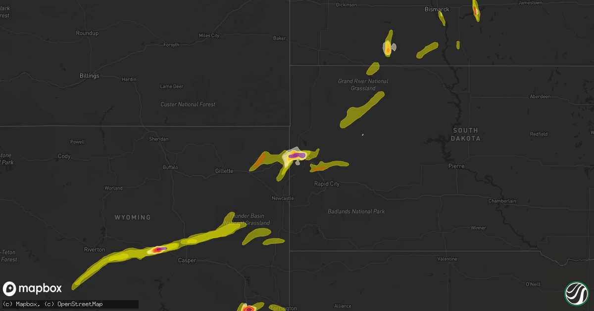
Hail Map on June 22, 2013
Get this storm
June 22 map
$229
one time, instant access
Download today. No call, no setup
Keep the $229
Bought the map and want the full workflow? Apply the entire $229 to a subscription within 7 days. None of it is wasted.
Every map, not just this one
This buys you this map. Subscription and you get every map we run, in the markets you choose from a few cities to whole states to nationwide. Plus real-time alerts the moment a storm fires.
Contact data
Name, contact info, occupancy, even credit band for addresses in the footprint. You go from where it hit to who to call.
Become the source they trust
Unlimited branding weather history reports on demand. You already have the documented answer ready for the property owner, and you are the one who showed up with it.
Property data and RoofTrace estimates
Pull up any address you have got, its value and the exact code rules for that jurisdiction, straight from One Click Code. Then RoofTrace estimates the squares, pitch, and roof value, priced the way you price.
States Impacted by Hail Map on June 22, 2013
Storm reports
Arkansas
| Date | Description |
|---|---|
| 06/22/20134:30 PM CDT | Power lines were blown down. |
Wisconsin
| Date | Description |
|---|---|
| 06/22/20139:42 AM CDT | Brief period of high wind gusts in wake of thunderstorm. |
| 06/22/20135:51 AM CDT | Wkbt reported large tree branches and powerline blown down |
| 06/21/20138:57 PM CDT | Wkbt reported that numerous trees and powerlines were blown down in ettrick |
| 06/21/20138:55 PM CDT | Rain wrapped tornado on the ground |
| 06/21/20138:55 PM CDT | Tree down and completely blocking hwy jg near hwy id. |
| 06/21/20138:45 PM CDT | Trees down in mazomanie and mt horeb |
South Dakota
| Date | Description |
|---|---|
| 06/22/20136:55 PM CDT | A local report indicates 60 MPH wind near 11 SSW REVA |
| 06/22/20136:55 PM CDT | 65 mph wnd gusts |
| 06/22/20136:50 PM CDT | A local report indicates 61 MPH wind near UNION CENTER |
| 06/22/20136:38 PM CDT | A local report indicates 60 MPH wind near RED OWL |
| 06/22/20136:31 PM CDT | A local report indicates 60 MPH wind near 7 NNE ELLSWORTH AFB |
| 06/22/20136:05 PM CDT | 60 mph wnd gusts from 505 pm to 520 pm |
| 06/22/20135:55 PM CDT | Also received about 3/4 inch rain. |
| 06/22/20135:44 PM CDT | Time estimated from radar. |
| 06/22/20135:35 PM CDT | A local report indicates 61 MPH wind near 4 N DOWNTOWN BELLE FOUR |
| 06/22/20135:30 PM CDT | A local report indicates 2.00 inch wind near 3 NW DOWNTOWN SPEARFISH |
| 06/22/20135:25 PM CDT | A local report indicates 1.50 inch wind near DOWNTOWN SPEARFISH |
| 06/22/20135:15 PM CDT | A local report indicates 59 MPH wind near 4 E DOWNTOWN SPEARFISH |
| 06/22/20135:11 PM CDT | A local report indicates 1.75 inch wind near 8 W DOWNTOWN SPEARFISH |
| 06/22/201312:46 AM CDT | A local report indicates 58 MPH wind near 2 N MITCHELL |
| 06/22/201312:09 AM CDT | Power pole snapped. |
| 06/21/201311:55 PM CDT | A local report indicates 58 MPH wind near WHITE LAKE |
| 06/21/201311:49 PM CDT | A local report indicates 1.25 inch wind near MADISON |
| 06/21/201311:40 PM CDT | A local report indicates 63 MPH wind near KIMBALL |
| 06/21/201310:59 PM CDT | A local report indicates 67 MPH wind near CHAMBERLAIN |
| 06/21/201310:55 PM CDT | A local report indicates 64 MPH wind near 2 W OACOMA |
| 06/21/201310:20 PM CDT | A few trees knocked over near white lake including a 6 inch in diameter cottonwood tree. |
| 06/21/201310:08 PM CDT | A local report indicates 1.00 inch wind near 7 ESE TRENT |
| 06/21/20139:00 PM CDT | A local report indicates 66 MPH wind near 3 W LEMMON |
| 06/21/20138:58 PM CDT | A local report indicates 60 MPH wind near 5 S MCLAUGHLIN |
| 06/21/20138:20 PM CDT | A local report indicates 60 MPH wind near ISABEL |
| 06/21/20138:00 PM CDT | A local report indicates 61 MPH wind near 7 SSE MEADOW |
| 06/21/20138:00 PM CDT | A local report indicates 60 MPH wind near 15 SE DUPREE |
| 06/21/20137:58 PM CDT | A local report indicates 60 MPH wind near 10 SE MEADOW |
| 06/21/20137:43 PM CDT | A local report indicates 59 MPH wind near SHAMBO RANCH |
| 06/21/20137:40 PM CDT | A local report indicates 78 MPH wind near 1 WSW RED ELM |
| 06/21/20137:40 PM CDT | Severe wind gusts lasted from 640 pm until 720 pm mdt |
| 06/21/20137:40 PM CDT | Outbuildings destroyed. Time estimated from radar. |
| 06/21/20137:31 PM CDT | Outbuilding roofs damaged. Some house damage. Time estimated from radar. |
| 06/21/20137:05 PM CDT | 65 mph wnd gusts |
| 06/21/20137:00 PM CDT | Wind broke small branches |
Illinois
| Date | Description |
|---|---|
| 06/22/20133:05 PM CDT | Fences blown down along edwin drive...a few pieces of siding blown off of a couple of homes. Two pilars on a front porch blown down. Garage door on a house blown out. |
| 06/22/20133:01 PM CDT | A local report indicates 1.00 inch wind near 2 SW LATHAM |
| 06/22/20131:45 PM CDT | Telephone pole in back yard snapped...several trees blown over and nickel size hail |
| 06/22/201312:00 PM CDT | Delayed report. Hail started as pea-sized then got up to the size of quarters. |
| 06/22/201311:15 AM CDT | 20 ft by 24 ft section of roofing shingles taken off a church on the northwest side of gibson city. Time is estimated. |
| 06/22/201311:03 AM CDT | 2 inch branches down. Est 50 mph winds. Power out. Visibility near zero. |
Minnesota
| Date | Description |
|---|---|
| 06/22/20135:00 AM CDT | Few trees and large branches down. |
| 06/22/20134:45 AM CDT | Several trees down along county road 21. |
| 06/22/20134:30 AM CDT | 1 ft branch split from the tree. |
| 06/22/20134:30 AM CDT | Several trees and large branches down around delano |
| 06/22/201312:55 AM CDT | Relayed from local media |
| 06/22/201312:55 AM CDT | Hail lasted about 10 minutes. Winds also took down two inch diameter branches. Corn and beans heavily damaged. |
| 06/21/20138:22 PM CDT | A local report indicates 1.00 inch wind near LUVERNE |
Colorado
| Date | Description |
|---|---|
| 06/22/201312:41 AM CDT | Pea to quarter size hail |
| 06/21/20137:43 PM CDT | A local report indicates 60 MPH wind near AKRON |
| 06/21/20137:03 PM CDT | A local report indicates 1.00 inch wind near 3 NNW WOODROW |
Nebraska
| Date | Description |
|---|---|
| 06/22/20136:30 PM CDT | Thunderstorm winds severely damaged a wheat crop in a 2 to 3 mile wide path...from 14 miles northwest of harrisburg to 7 miles east of that location. |
| 06/22/20136:26 PM CDT | Tornado visible between 526 and 532 pm mdt. Tornado dissipated shortly thereafter. Report from off duty spc forecaster. |
| 06/22/20136:10 PM CDT | Hail mostly quarter sized with some to size of tennis balls. Heavy rain with vis down to 1/8 mi. 2 windows damaged. One cracked. One broken out. Both on north side of h |
| 06/22/20136:04 PM CDT | Center pivot partially overturned. |
| 06/22/20136:00 PM CDT | Tornado produced damage at a house 7 miles north and 14 miles west of harrisburg...about 2.5 miles east of the wyoming state line. A house at that location received con |
| 06/22/20135:51 PM CDT | Tornado visible between 451 and 456 pm mdt. Report from off duty spc forecaster. |
| 06/22/20135:50 PM CDT | Nws damage survey confirmed ef-1 tornado damage in northwest banner county on june 22nd. Tornado developed 17 wnw harrisburg at about 450 pm and tracked ese before diss |
| 06/22/20131:30 AM CDT | A local report indicates 59 MPH wind near 9 NNE LEXINGTON |
| 06/22/20131:19 AM CDT | Downed power line with adjacent tree on fire. One inch hail also being reported. |
| 06/22/20131:08 AM CDT | Deputy sheriff reports 1 inch hail and heavy rain. |
| 06/22/20131:08 AM CDT | Deputy sheriff reports 1 inch hail and heavy rain. |
| 06/22/20131:00 AM CDT | Golf ball hail coming down sideways. Estimated 80 mph winds. |
| 06/22/20131:00 AM CDT | Delayed report...from about 4 miles west of highway 283 to about 3 miles east of highway 283...crop damage was discovered about 2 miles north of the gosper/furnas count |
| 06/22/201312:57 AM CDT | A local report indicates 60 MPH wind near 1 ESE EWING |
| 06/22/201312:56 AM CDT | Quarter size hail and winds estimated at 60 to 70 mph on hiway 283 near mile marker 30. |
| 06/22/201312:55 AM CDT | Power outage reported by local law enforcement. |
| 06/22/201312:30 AM CDT | Power outage reported by local law enforcement. |
| 06/22/201312:30 AM CDT | The combination of wind and hail stripped some corn in the field. Hail was estimated at dime size and wind gusts were over 50 mph. |
| 06/22/201312:23 AM CDT | 67 mph wind gust measured with automated equipment at ord airport. |
| 06/22/201312:15 AM CDT | A large limb... Approx 4 inches in diameter... Broke off. Time is estimated off radar. |
| 06/22/201312:15 AM CDT | Power outage reported by local law enforcement. |
| 06/22/201312:12 AM CDT | Via social media |
| 06/22/201312:00 AM CDT | A local report indicates 1.00 inch wind near 3 WNW MCCOOK |
| 06/21/201311:35 PM CDT | Thunderstorm wind gust measured at 58 mph. |
| 06/21/201311:30 PM CDT | An apparent micro-burst overturned a pivot irrigator and left nearby pivots unaffected. |
| 06/21/201311:30 PM CDT | Time estimated based on radar |
| 06/21/201311:21 PM CDT | Delayed report. Multiple trees and power lines down in mullen. |
| 06/21/201311:15 PM CDT | Wind gust of 60 mph measured by the thomas county airport asos. |
| 06/21/201310:58 PM CDT | Power is out in mullen...street signs have been knocked down. Wind estimated by law enforcement at 70 mph. |
| 06/21/201310:56 PM CDT | A local report indicates 60 MPH wind near MULLEN |
| 06/21/201310:55 PM CDT | Wind gust of 67 mph recorded by the north platte airport asos. |
| 06/21/201310:50 PM CDT | A local report indicates 1.75 inch wind near 1 N HAYES CENTER |
| 06/21/201310:45 PM CDT | A local report indicates 2.75 inch wind near 2 W HAYES CENTER |
| 06/21/20139:35 PM CDT | A local report indicates 1.00 inch wind near MAYWOOD |
| 06/21/20137:59 PM CDT | Tornado lifted at 702 pm. |
| 06/21/20137:58 PM CDT | Tornado was on interstate 80. |
| 06/21/20137:26 PM CDT | A local report indicates 1.00 inch wind near 4 WSW REDINGTON |
| 06/21/20137:19 PM CDT | Reported at bushnell and at oliver lake. |
| 06/21/20137:08 PM CDT | A local report indicates 1.00 inch wind near 4 W OLIVER RESERVOIR |
| 06/21/20137:03 PM CDT | 50 to 60 mph wind gusts and nickel sized hail at the intersection of stonegate and highland roads. |
Kansas
| Date | Description |
|---|---|
| 06/22/20136:53 PM CDT | Measured quarter size hail and some was larger. Estimated to half dollar size. |
| 06/22/20136:52 PM CDT | Nickel to quarter size hail. Started hailing 10 minutes ago. |
| 06/22/20136:52 PM CDT | Nickel to quarter size hail. Started hailing 10 minutes ago. |
| 06/22/20138:33 AM CDT | Most of the hail was pea to dime but 1 stone was the size of a quarter. |
| 06/21/20138:25 PM CDT | Mesonet measured 70 mph wind gust |
| 06/21/20137:15 PM CDT | Quarter size hail off and on for the past 30 minutes. |
Ohio
| Date | Description |
|---|---|
| 06/22/20136:05 PM CDT | Downed power lines on ford street prompting a road closure. |
| 06/22/20134:25 PM CDT | 8 inch limb down on house on s gorham street |
| 06/22/20132:26 PM CDT | Scattered trees down from moorefield twp to champaign county line. Time estimated from radar. |
| 06/21/20137:49 PM CDT | Many small to medium size limbs down throughout bowling green. |
| 06/21/20137:44 PM CDT | Many healthy trees down. 2 trees fell on a house. |
| 06/21/20137:44 PM CDT | One tree uprooted. |
| 06/21/20137:21 PM CDT | Multiple trees and power lines down. |
| 06/21/20137:00 PM CDT | Tree down on cr q between cr 2 and wood co line |
North Dakota
| Date | Description |
|---|---|
| 06/22/20131:30 AM CDT | Tree branches up to 6 inches in diameter felled...time estimated. |
| 06/22/201312:40 AM CDT | Two 6 inch branches were down 2n 0.5e leeds |
| 06/21/201311:25 PM CDT | A local report indicates 1.50 inch wind near RUGBY |
| 06/21/201310:25 PM CDT | Report relayed through harvey radio station |
| 06/21/201310:21 PM CDT | 40 to 50 feet trees uprooted along washington street. Reported by nws employee. |
| 06/21/201310:15 PM CDT | Trees damaged in bismarck |
| 06/21/201310:00 PM CDT | Winds estimated at 75 mph. Winds took roof off of a building...and thrown into house and car. Car was totaled...house was damaged. |
| 06/21/20139:30 PM CDT | A local report indicates 60 MPH wind near 3 S BISMARCK |
| 06/21/20139:26 PM CDT | Very heavy rain and hail up to the size of nickels also reported |
| 06/21/20139:25 PM CDT | Torrential rain was also reported. |
| 06/21/20139:25 PM CDT | Measured by the tatanka prairie raws site. |
| 06/21/20139:24 PM CDT | Reported by nws employee. |
| 06/21/20139:24 PM CDT | Reported by nws employee. |
| 06/21/20138:49 PM CDT | 70 mph winds were accompanied by one inch hail |
| 06/21/20138:35 PM CDT | Wind damage with estimated at 70mph... 0.90 inches of rainfall |
| 06/21/20138:26 PM CDT | Peak wind gust at hettinger airport measured at 58 mph. |
| 06/21/20138:25 PM CDT | Nickel to quarter sized hail with estimated 60 mph gust. Hail was covering ground. |
| 06/21/20138:25 PM CDT | Nickel to quarter sized hail with estimated 60 mph gust. Hail was covering ground. |
| 06/21/20138:20 PM CDT | Nickels to dime sized hail with 60 mph hour gusts. |
| 06/21/20138:15 PM CDT | Dime to quarter sized hail. |
| 06/21/20138:09 PM CDT | Hail began at 800 pm and still ongoing at 809 pm. |
| 06/21/20138:09 PM CDT | Hail began at 800 pm and still ongoing at 809 pm. |
| 06/21/20138:00 PM CDT | Pea to golfball sized hail. Hail lasted approx 30 minutes. |
Wyoming
| Date | Description |
|---|---|
| 06/22/20136:23 PM CDT | A local report indicates 1.50 inch wind near 8 SW ALBIN |
| 06/22/20135:54 PM CDT | A local report indicates 1.50 inch wind near LA GRANGE |
| 06/22/20135:21 PM CDT | A local report indicates 63 MPH wind near 1 N BEULAH |
| 06/22/20135:21 PM CDT | A local report indicates 63 MPH wind near BEULAH |
| 06/22/20135:16 PM CDT | Some nickel size |
| 06/22/20135:00 PM CDT | A local report indicates 1.00 inch wind near 8 NE SUNDANCE |
| 06/22/20134:55 PM CDT | A local report indicates 1.50 inch wind near 6 SSE YODER |
| 06/22/20134:54 PM CDT | Tornado touchdown at 354 pm. |
| 06/22/20134:44 PM CDT | A local report indicates 79 MPH wind near 7 SSE SUNDANCE |
| 06/22/20134:15 PM CDT | Barn roof lifted off. |
| 06/22/20134:11 PM CDT | A local report indicates 59 MPH wind near PINE HAVEN |
| 06/22/20134:05 PM CDT | A local report indicates 60 MPH wind near 9 SSE WESTON |
| 06/22/20133:45 PM CDT | Strong winds accompanied the hail. Hail lasted about 5 minutes. |
| 06/22/20133:36 PM CDT | Pea size hail. |
| 06/22/20133:29 PM CDT | A local report indicates 61 MPH wind near 5 NNW DOWNTOWN GILLETTE |
| 06/22/20133:21 PM CDT | A local report indicates 4.25 inch wind near WHEATLAND |
| 06/22/20133:00 PM CDT | A local report indicates 2.00 inch wind near WHEATLAND |
| 06/22/20133:00 PM CDT | A local report indicates 2.00 inch wind near 1 SW WHEATLAND |
| 06/22/20132:58 PM CDT | Tornado touchdown briefly 5 miles south of wheatland. On the ground for approximately one minute before lifting. |
| 06/22/20132:56 PM CDT | A local report indicates a tornado near 5 W WHEATLAND |
| 06/22/20132:50 PM CDT | A local report indicates 1.00 inch wind near 2 W WHEATLAND |
| 06/22/20132:36 PM CDT | A local report indicates 1.00 inch wind near 22 N CASPER |
| 06/22/20131:47 PM CDT | Cars with damage pulled over on highway |
| 06/22/20131:30 PM CDT | Hail broke windows in spotters home. |
Iowa
| Date | Description |
|---|---|
| 06/22/20137:57 AM CDT | A local report indicates 58 MPH wind near DUBUQUE REGIONAL AIRPOR |
| 06/22/20134:10 AM CDT | A local report indicates 58 MPH wind near ESTHERVILLE |
| 06/21/201311:55 PM CDT | Public report relayed by kimt tv in mason city. |
| 06/21/20138:17 PM CDT | Trained spotter reported quarter size hail and estimated around half an inch of rain in 20 minutes |
| 06/21/20138:03 PM CDT | A local report indicates 1.00 inch wind near 1 ESE LARCHWOOD |
| 06/21/20137:59 PM CDT | Trained spotter reported quarter to golf ball size hail |
Indiana
| Date | Description |
|---|---|
| 06/22/20133:40 PM CDT | Tree down and several sheets of siding off building on s 800 w. Steel pole barn doors blown off on w 1100 s |
| 06/22/20133:40 PM CDT | 10x20ft section of shingles off of building at gardens of memory cemetary near sr 218 and sr 9. Spotter estimated 65 mph wind gust |
| 06/22/20133:23 PM CDT | Large tree limb blocking wb lanes of us 24 near 600 n |
| 06/22/20133:15 PM CDT | Large tree limb down at gardendale and engle streets. Limb was too big for 2 officers to move |
| 06/22/20133:15 PM CDT | Large tree down on frederick street in between hannah st and herman st. |
| 06/22/20133:05 PM CDT | Several large tree limbs down in cemetary on river road w of sr105 |
| 06/22/20133:00 PM CDT | Tree down and several sheets of siding off building on s 800 w. Steel pole barn doors blown off on w 1100 s |
| 06/22/20132:41 PM CDT | Trees downed from 1st to 3rd streets. Also some corn crops flattened and shredded in western part of county. One tree fell on several cars in rushville. |
| 06/22/20132:25 PM CDT | Tree down near 1400 n and 400e. Additonal trees down on sr 19 near 1500 n. |
Missouri
| Date | Description |
|---|---|
| 06/22/20135:29 PM CDT | Several power lines and large trees down on the west side of west plains. |
| 06/22/20135:29 PM CDT | Microburst hit the western side of west plains. Trees and power lines down across the parking lot at crossroads convenience store. |
| 06/22/20135:29 PM CDT | Roof blown off of a building |
| 06/22/20135:29 PM CDT | Large tree down near highway cc and country club drive. Report received via twitter. |
| 06/22/20135:14 PM CDT | Howell county 911 relayed to the nws that severe thunderstorm wind gusts downed a tree across highway 14 in western howell county. |
| 06/22/20133:52 PM CDT | The karr kare and convenience store in summersville had customers report trees down along a highway near the community from severe thunderstorm wind gusts. |
| 06/22/20131:55 PM CDT | Large tree blown down blocking the intersection of highway pp and w. |
| 06/22/20131:52 PM CDT | Bradford pear blown down and off a larger tree... 4 to 6 inch diameter limb down |
Montana
| Date | Description |
|---|---|
| 06/22/20131:55 PM CDT | A local report indicates 1.00 inch wind near 5 N REED POINT |
| 06/22/20131:40 PM CDT | A local report indicates 1.00 inch wind near 5 N REED POINT |
Michigan
| Date | Description |
|---|---|
| 06/22/20133:40 PM CDT | 12 inch diameter tree downed |
Cities Impacted by Hail Map on June 22, 2013
- Lytton, IA
- Latham, IL
- Warrensburg, IL
- New Leipzig, ND
- Elgin, ND
- Arapahoe, NE
- Elwood, NE
- Eustis, NE
- Casper, WY
- Harrisburg, NE
- Lyman, NE
- Yoder, WY
- Lagrange, WY
- Hawk Springs, WY
- Jolley, IA
- Rockwell City, IA
- Pomeroy, IA
- Lake View, IA
- Lake City, IA
- Fonda, IA
- Sac City, IA
- Auburn, IA
- Holbrook, NE
- Bertrand, NE
- Cheyenne, WY
- Meriden, WY
- Belle Fourche, SD
- Spearfish, SD
- Gering, NE
- Torrington, WY
- Albin, WY
- Wheatland, WY
- Leoti, KS
- Rugby, ND
- Hayes Center, NE
- Palisade, NE
- London, OH
- Steele, ND
- Bismarck, ND
- Bushnell, NE
- Burns, WY
- Pine Bluffs, WY
- Wauneta, NE
- Saint Onge, SD
- Beulah, WY
- Whitewood, SD
- Sundance, WY
- Madison, SD
- Glenville, MN
- Austin, MN
- Lyle, MN
- Northwood, IA
- Lead, SD
- Carson, ND
- McCook, NE
- Kimball, NE
- Culbertson, NE
- Linton, ND
- Tribune, KS
- Max, NE
- Trenton, NE
- Stratton, NE
- Bartley, NE
- Stockville, NE
- Benkelman, NE
- Bird City, KS
- Indianola, NE
- Bridgeport, NE
- Chugwater, WY
- Bayard, NE
- Broadwater, NE
- Potter, NE
- Dix, NE
- Lingle, WY
- Veteran, WY
- Angora, NE
- Guernsey, WY
- Glenrock, WY
- Douglas, WY
- Lander, WY
- Shoshoni, WY
- Jeffrey City, WY
- Gillette, WY
- Bennett, CO
- Brush, CO
- Byers, CO
- Woodrow, CO
- Wiggins, CO
- Hudson, CO
- Keenesburg, CO
- Roggen, CO
- Fort Morgan, CO
- Strasburg, CO
- La Salle, CO
- Kersey, CO
- Hettinger, ND
- Lemmon, SD
- Sturgis, SD
- New Underwood, SD
- Piedmont, SD
- Lance Creek, WY
- Newell, SD
- Aladdin, WY
- Vale, SD
- Devils Tower, WY
- Moorcroft, WY
- Osage, WY
- Newcastle, WY
- Lusk, WY
- Meadow, SD
- Bison, SD
- Mud Butte, SD
- Faith, SD
- Prairie City, SD
- Loomis, NE
- Moorefield, NE
- Holdrege, NE
- Cambridge, NE
- Smithfield, NE
- Selfridge, ND
- Solen, ND
- Fort Yates, ND
- Mandan, ND
- Kintyre, ND
- Driscoll, ND
- Dawson, ND
- Osage, IA
- Thornton, IA
- Rockwell, IA
- Rudd, IA
- Nora Springs, IA
- Rockford, IA
- Swaledale, IA
- Floyd, IA
- Mason City, IA
- Sheffield, IA
- Canton, SD
- Larchwood, IA
- Inwood, IA
- Steen, MN
- Hills, MN
- Beaver Creek, MN
- Magnolia, MN
- Luverne, MN
- Trent, SD
- Dell Rapids, SD
- Flandreau, SD