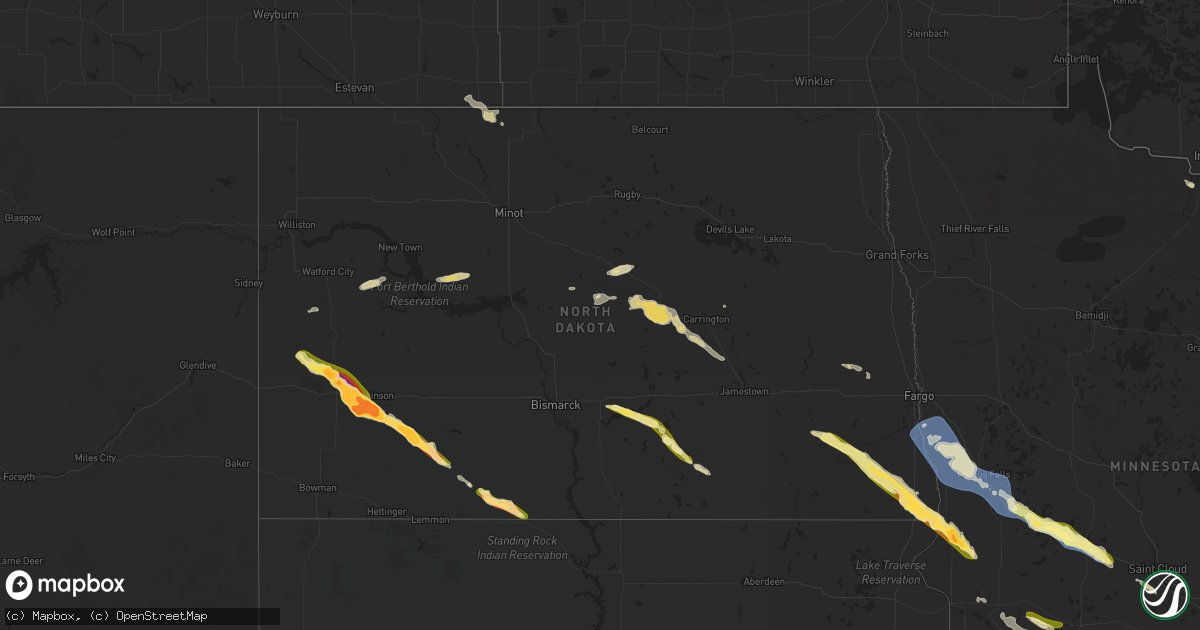
Hail Map in North Dakota on June 19, 2025
Get this storm
June 19 map
$229
one time, instant access
Download today. No call, no setup
Keep the $229
Bought the map and want the full workflow? Apply the entire $229 to a subscription within 7 days. None of it is wasted.
Every map, not just this one
This buys you this map. Subscription and you get every map we run, in the markets you choose from a few cities to whole states to nationwide. Plus real-time alerts the moment a storm fires.
Contact data
Name, contact info, occupancy, even credit band for addresses in the footprint. You go from where it hit to who to call.
Become the source they trust
Unlimited branding weather history reports on demand. You already have the documented answer ready for the property owner, and you are the one who showed up with it.
Property data and RoofTrace estimates
Pull up any address you have got, its value and the exact code rules for that jurisdiction, straight from One Click Code. Then RoofTrace estimates the squares, pitch, and roof value, priced the way you price.
Storm reports in North Dakota
North Dakota
| Date | Description |
|---|---|
| 06/19/20256:53 PM CDT | Belfield ndawn station camera. |
| 06/19/20256:35 PM CDT | Relayed from public. Time estimated from radar. |
| 06/19/202510:40 AM CDT | Relayed from nws employee. |
| 06/19/202512:30 AM CDT | Tree damage. |
| 06/18/202510:40 PM CDT | Corrects previous hail report from 9 nne burnstad for time. Relayed from nws employee. |
| 06/18/202510:07 PM CDT | Report from skyspy photos. |
| 06/18/20259:43 PM CDT | Ping-pong ball sized hail reported between exit 1 and exit 8 on i-29. |
| 06/18/20259:31 PM CDT | Tempest weather station recorded a wind gust of 65 mph at 9:31 cdt. |
| 06/18/20259:26 PM CDT | Estimated nickel to quarter size hail at the hankinson school. |
| 06/18/20259:18 PM CDT | Mping report of large hail. |
| 06/18/20259:15 PM CDT | Report from icechip research project. |
| 06/18/20259:00 PM CDT | Corrects previous hail report from hankinson. Estimated nickel to quarter size hail at the hankinson school. |
| 06/18/20258:40 PM CDT | Up to quarter size hail reported outside dollar general in wyndmere. Time estimated via radar. |
| 06/18/20258:30 PM CDT | Report from skyspy photos. Time estimated from radar. |
| 06/18/20257:45 PM CDT | Report from skyspy photos. |
| 06/18/20257:40 PM CDT | Report from skyspy photos. Time estimated from radar. |
| 06/18/20257:30 PM CDT | Photo relayed through broadcast media. |
| 06/18/20257:24 PM CDT | Emergency manager reports tornado damage near 117th ave sw and 44th st sw south about a mile to 117th ave sw and 46th st sw. Damage includes two houses with roofs parti |
| 06/18/20257:23 PM CDT | Hail began at 723 cdt and lasted two minutes. Hail from the size of quarters to a few golf ball sized stones. |
| 06/18/20257:23 PM CDT | Emergency manager reported 2.5 inch hail 45 minutes after hail fell. Also noted a lot of window and siding damage. About 20 to 30 windows damaged on north and east side |
| 06/18/20257:22 PM CDT | Tornado reported on the ground southwest of dickinson. |
| 06/18/20257:20 PM CDT | Relayed through broadcast media. Time estimated from radar. |
| 06/18/20257:15 PM CDT | Report from skyspy photos. Time estimated from radar. |
All States Impacted by Hail Map on June 19, 2025
Cities Impacted by Hail Map on June 19, 2025
- Hernando, MS
- Coldwater, MS
- Senatobia, MS
- Tupelo, MS
- Pontotoc, MS
- Sarah, MS
- Como, MS
- Sledge, MS
- Dundee, MS
- Coahoma, MS
- Crenshaw, MS
- Sardis, MS
- Batesville, MS
- Marks, MS
- Pope, MS
- Courtland, MS
- Lambert, MS
- Enid, MS
- Riceville, IA
- Chester, IA
- Clarksdale, MS
- Friars Point, MS
- Helena, AR
- Alligator, MS
- Duck Hill, MS
- Crumrod, AR
- Duncan, MS
- Snow Lake, AR
- Dunnellon, FL
- Gunnison, MS
- Ocala, FL
- Shelby, MS
- Watson, AR
- Rosedale, MS
- Redfield, AR
- England, AR
- Tucker, AR
- Sherrill, AR
- Hensley, AR
- Beulah, MS
- Boones Mill, VA
- Ponce De Leon, FL
- Jefferson, AR
- Benoit, MS
- Sheridan, AR
- Hardy, VA
- Wirtz, VA
- Rocky Mount, VA
- Lenoir, NC
- Vernon, FL
- White Hall, AR
- Greenville, MS
- Rohwer, AR
- Collinsville, VA
- Martinsville, VA
- Taylorsville, NC
- Moravian Falls, NC
- Fieldale, VA
- Basking Ridge, NJ
- Far Hills, NJ
- Lutz, FL
- Tampa, FL
- Pine Bluff, AR
- Elkton, VA
- McGaheysville, VA
- Harrisonburg, VA
- Keezletown, VA
- Shenandoah, VA
- New Market, VA
- Broadway, VA
- Stanley, VA
- Etlan, VA
- Syria, VA
- Banco, VA
- Madison, VA
- Grady, AR
- Stanfordville, NY
- Clinton Corners, NY
- Valparaiso, FL
- Eglin Afb, FL
- Yorktown, AR
- Reva, VA
- Boston, VA
- Culpeper, VA
- Amenia, NY
- Pine Plains, NY
- Oakville, CT
- Castleton, VA
- Woodville, VA
- Millerton, NY
- Norman, AR
- Bonnerdale, AR
- Waterbury, CT
- Thomaston, CT
- Middlebury, CT
- Watertown, CT
- Short Hills, NJ
- South Orange, NJ
- Millburn, NJ
- Springfield, NJ
- Vauxhall, NJ
- Maplewood, NJ
- Terryville, CT
- Plymouth, CT
- Bristol, CT
- Burlington, CT
- Grapevine, AR
- Lebanon, NJ
- Whitehouse Station, NJ
- Plant City, FL
- Annandale, NJ
- Defuniak Springs, FL
- Niceville, FL
- Brandy Station, VA
- Wolcott, CT
- Newark, NJ
- Irvington, NJ
- Amissville, VA
- Troy, AL
- Luray, VA
- Sperryville, VA
- Haywood, VA
- Rixeyville, VA
- Rileyville, VA
- Bentonville, VA
- Washington, VA
- Huntly, VA
- Marshall, VA
- Flint Hill, VA
- Warrenton, VA
- Hume, VA
- Remington, VA
- Jeffersonton, VA
- Chester Gap, VA
- Markham, VA
- Catharpin, VA
- Delaplane, VA
- Chantilly, VA
- Broad Run, VA
- Centreville, VA
- Haymarket, VA
- Elkwood, VA
- Linden, VA
- Gainesville, VA
- Manassas, VA
- Nokesville, VA
- Bealeton, VA
- Midland, VA
- Catlett, VA
- The Plains, VA
- Bristow, VA
- Little River, AL
- Ariton, AL
- Elkton, FL
- Sharon, CT
- Belzoni, MS
- Marshallville, GA
- Front Royal, VA
- Aldie, VA
- Upperville, VA
- Middleburg, VA
- Goldvein, VA
- Sumerduck, VA
- Herndon, VA
- Sterling, VA
- Ashburn, VA
- Clifton, VA
- Triangle, VA
- Fairfax Station, VA
- Woodbridge, VA
- Fairfax, VA
- Quantico, VA
- Stafford, VA
- Dumfries, VA
- McLean, VA
- Reston, VA
- Great Falls, VA
- Burke, VA
- Springfield, VA
- Vienna, VA
- Oakton, VA
- Annandale, VA
- Leesburg, VA
- Lorton, VA
- Potomac, MD
- Gaithersburg, MD
- Germantown, MD
- Poolesville, MD
- Occoquan, VA
- Rockville, MD
- Marbury, MD
- Bethesda, MD
- Accokeek, MD
- La Plata, MD
- Arlington, VA
- Dunn Loring, VA
- Falls Church, VA
- Cabin John, MD
- Alexandria, VA
- Indian Head, MD
- Fort Belvoir, VA
- Bryans Road, MD
- Hazelhurst, WI
- Minocqua, WI
- Dillwyn, VA
- Farmville, VA
- Hiddenite, NC
- Union Grove, NC
- Saint Augustine, FL
- Nanjemoy, MD
- Elba, AL
- Fredericksburg, VA
- Port Tobacco, MD
- White Plains, MD
- Waldorf, MD
- Pomfret, MD
- Union Bridge, MD
- Mount Airy, MD
- New Windsor, MD
- Woodbine, MD
- Sykesville, MD
- Westminster, MD
- Reisterstown, MD
- Finksburg, MD
- Hampstead, MD
- Upperco, MD
- Glyndon, MD
- Owings Mills, MD
- Cockeysville, MD
- Parkton, MD
- Sparks Glencoe, MD
- Monkton, MD
- Phoenix, MD
- Jarrettsville, MD
- Forest Hill, MD
- Baldwin, MD
- Fallston, MD
- White Hall, MD
- Street, MD
- Pylesville, MD
- Whiteford, MD
- Delta, PA
- Fawn Grove, PA
- Chevy Chase, MD
- Fort Washington, MD
- Fort Myer, VA
- Glen Echo, MD
- Derwood, MD
- Washington, DC
- Lake Tomahawk, WI
- Charlottesville, VA
- Caddo Gap, AR
- Donalsonville, GA
- Hamptonville, NC
- North Wilkesboro, NC
- Plainfield, NJ
- Watchung, NJ
- Dunellen, NJ
- Lizella, GA
- Macon, GA
- Statesville, NC
- Summit, NJ
- Brandywine, MD
- Clinton, MD
- Oxon Hill, MD
- Temple Hills, MD
- Silver Spring, MD
- Bryantown, MD
- Garrett Park, MD
- Naval Anacost Annex, DC
- Kensington, MD
- Greenbelt, MD
- Capitol Heights, MD
- Riverdale, MD
- Annapolis Junction, MD
- Andrews Air Force Base, MD
- Savage, MD
- Laurel, MD
- Brentwood, MD
- Burtonsville, MD
- Jessup, MD
- Fort George G Meade, MD
- Lanham, MD
- Bowie, MD
- Sandy Spring, MD
- College Park, MD
- Glenn Dale, MD
- Suitland, MD
- Beltsville, MD
- Bladensburg, MD
- Ashton, MD
- Cheltenham, MD
- District Heights, MD
- Fulton, MD
- Takoma Park, MD
- Columbia, MD
- Mount Rainier, MD
- Spencerville, MD
- Hyattsville, MD
- Olney, MD
- Upper Marlboro, MD
- Bel Air, MD
- Darlington, MD
- Drumore, PA
- Peach Bottom, PA
- Rising Sun, MD
- Conowingo, MD
- Oxford, PA
- Port Deposit, MD
- Nottingham, PA
- Kirkwood, PA
- Colora, MD
- North East, MD
- Quarryville, PA
- Rison, AR
- Mount Ida, AR
- Jack, AL
- Airville, PA
- New Park, PA
- Olin, NC
- Union, NJ
- Adel, GA
- Harmony, NC
- Scotch Plains, NJ
- Fanwood, NJ
- Churchville, MD
- Havre De Grace, MD
- Perryville, MD
- Elkton, MD
- Lincoln University, PA
- Cochranville, PA
- Wilmot, NH
- Danbury, NH
- Opp, AL
- Deltona, FL
- Osteen, FL
- Keswick, VA
- McKenzie, AL
- Staten Island, NY
- Jersey City, NJ
- Bayonne, NJ
- New York, NY
- Brooklyn, NY
- Flushing, NY
- Elmhurst, NY
- East Elmhurst, NY
- Astoria, NY
- Ozone Park, NY
- Middle Village, NY
- Kew Gardens, NY
- Ridgewood, NY
- Maspeth, NY
- Sunnyside, NY
- Woodhaven, NY
- South Richmond Hill, NY
- Long Island City, NY
- Forest Hills, NY
- Corona, NY
- Richmond Hill, NY
- Woodside, NY
- Jackson Heights, NY
- Rego Park, NY
- Newark, DE
- Landenberg, PA
- West Grove, PA
- Avondale, PA
- Coatesville, PA
- Hockessin, DE
- West Chester, PA
- Kennett Square, PA
- Toughkenamon, PA
- Harwood, MD
- Deale, MD
- Crofton, MD
- West River, MD
- Gambrills, MD
- Odenton, MD
- Owings, MD
- Lothian, MD
- Friendship, MD
- Tracys Landing, MD
- Dunkirk, MD
- Davidsonville, MD
- Harmans, MD
- Glen Burnie, MD
- Hanover, MD
- Crownsville, MD
- Edgewater, MD
- Severna Park, MD
- Arnold, MD
- Riva, MD
- Pasadena, MD
- Galesville, MD
- Shady Side, MD
- Churchton, MD
- Millersville, MD
- Annapolis, MD
- Severn, MD
- Gibson Island, MD
- Springfield, NH
- Wilmington, DE
- Chadds Ford, PA
- Yorklyn, DE
- Geneva, FL
- Valparaiso, IN
- Chesterton, IN
- New Edinburg, AR
- Oden, AR
- Kinston, AL
- Langley, AR
- Portage, IN
- Wilmar, AR
- Florala, AL
- Foxworth, MS
- Kokomo, MS
- Hill, NH
- New Smyrna Beach, FL
- Rockland, DE
- Montchanin, DE
- Bronx, NY
- Hoboken, NJ
- Jamaica, NY
- College Point, NY
- Whitestone, NY
- Bellerose, NY
- Oakland Gardens, NY
- Queens Village, NY
- Hollis, NY
- Fresh Meadows, NY
- Bayside, NY
- Thornton, PA
- Marcus Hook, PA
- Garnet Valley, PA
- Claymont, DE
- Glen Mills, PA
- Chester Heights, PA
- Chester, PA
- Aston, PA
- Wallingford, PA
- Brookhaven, PA
- Newtown Square, PA
- Media, PA
- Cheyney, PA
- Bristol, NH
- Claiborne, MD
- Stevensville, MD
- Saint Michaels, MD
- Wittman, MD
- Easton, MD
- Chester, MD
- Mcdaniel, MD
- Grasonville, MD
- Queenstown, MD
- Rock Hall, MD
- Chestertown, MD
- Wye Mills, MD
- Centreville, MD
- Fort Howard, MD
- Curtis Bay, MD
- Sparrows Point, MD
- Worton, MD
- Still Pond, MD
- Galena, MD
- Earleville, MD
- Sudlersville, MD
- Kennedyville, MD
- Church Hill, MD
- Warwick, MD
- Millington, MD
- Cordova, MD
- Queen Anne, MD
- Crumpton, MD
- Georgetown, MD
- Little Neck, NY
- Garden City, NY
- Great Neck, NY
- Floral Park, NY
- New Hyde Park, NY
- Glen Oaks, NY
- Roslyn, NY
- Carle Place, NY
- Manhasset, NY
- Roslyn Heights, NY
- Albertson, NY
- Williston Park, NY
- Hicksville, NY
- Levittown, NY
- Old Westbury, NY
- Westbury, NY
- Mineola, NY
- East Meadow, NY
- Old Bethpage, NY
- Greenvale, NY
- Glenwood Landing, NY
- Melville, NY
- Syosset, NY
- Bethpage, NY
- Jericho, NY
- Port Washington, NY
- Glen Head, NY
- Plainview, NY
- Sea Cliff, NY
- Glen Cove, NY
- Locust Valley, NY
- Mill Neck, NY
- East Norwich, NY
- Oyster Bay, NY
- Woodbury, NY
- Huntington, NY
- Farmingdale, NY
- Pearl River, LA
- Samson, AL
- Trinidad, CO
- Model, CO
- Moss Point, MS
- Winston Salem, NC
- Lewisville, NC
- Warren, AR
- Columbia, MS
- Clemmons, NC
- Swarthmore, PA
- Crum Lynne, PA
- Woodlyn, PA
- Broomall, PA
- Folcroft, PA
- Clifton Heights, PA
- Springfield, PA
- Norwood, PA
- Prospect Park, PA
- Folsom, PA
- Morton, PA
- Glenolden, PA
- Holmes, PA
- Ridley Park, PA
- Sharon Hill, PA
- Drexel Hill, PA
- Bala Cynwyd, PA
- Gladwyne, PA
- Havertown, PA
- Merion Station, PA
- Haverford, PA
- Wynnewood, PA
- Philadelphia, PA
- Bryn Mawr, PA
- Lansdowne, PA
- Narberth, PA
- Upper Darby, PA
- Ardmore, PA
- Darby, PA
- Essex, MD
- Gunpowder, MD
- Betterton, MD
- Ridgely, MD
- Barclay, MD
- Goldsboro, MD
- Chesapeake City, MD
- Denton, MD
- Henderson, MD
- Greensboro, MD
- Ingleside, MD
- Cecilton, MD
- Massey, MD
- Marydel, MD
- Clayton, DE
- Middletown, DE
- New Castle, DE
- Townsend, DE
- Bear, DE
- Odessa, DE
- Smyrna, DE
- Wyncote, PA
- Bryn Athyn, PA
- Bensalem, PA
- Jenkintown, PA
- Cheltenham, PA
- Huntingdon Valley, PA
- Elkins Park, PA
- Feasterville Trevose, PA
- Glenside, PA
- Abington, PA
- Monticello, AR
- Tripoli, WI
- Nashville, GA
- Vancleave, MS
- Glenwood, AR
- Alva, FL
- Lehigh Acres, FL
- Millen, GA
- New Hampton, NH
- Cold Spring Harbor, NY
- Huntington Station, NY
- Centerport, NY
- Greenlawn, NY
- Kings Park, NY
- Smithtown, NY
- East Northport, NY
- Commack, NY
- Northport, NY
- Saint James, NY
- Delaware City, DE
- Saint Georges, DE
- Smithville, OK
- Chauncey, GA
- Punta Gorda, FL
- Sylvania, GA
- Watersmeet, MI
- Mena, AR
- Umpire, AR
- Douglas, GA
- Jakin, GA
- Willacoochee, GA
- Iron River, MI
- Tomahawk, WI
- Salem, NJ
- Port Penn, DE
- Pennsville, NJ
- Penns Grove, NJ
- Woodstown, NJ
- Pedricktown, NJ
- Blue Bell, PA
- Watson, OK
- Pearson, GA
- Abita Springs, LA
- Covington, LA
- Ponchatoula, LA
- Springfield, LA
- Biloxi, MS
- Diberville, MS
- Newhope, AR
- Milan, GA
- Eastman, GA
- Winona, KS
- Holly, CO
- Fort White, FL
- Ambler, PA
- Devon, PA
- Berwyn, PA
- Paoli, PA
- King Of Prussia, PA
- Wayne, PA
- Lake City, FL
- Lake Placid, FL
- Conshohocken, PA
- Colby, KS
- Boncarbo, CO
- North Fort Myers, FL
- Lawrence Township, NJ
- Long Beach, MS
- Bryant Pond, ME
- Rumford, ME
- Gulfport, MS
- Prince George, VA
- Hopewell, VA
- Norristown, PA
- Malvern, PA
- Keshena, WI
- Merrill, WI
- Wausau, WI
- Bush, LA
- Trenton, NJ
- Princeton, NJ
- Princeton Junction, NJ
- Pennington, NJ
- Bassett, NE
- Madisonville, LA
- Pass Christian, MS
- Star City, AR
- Gillett, WI
- Matawan, NJ
- Holmdel, NJ
- Hazlet, NJ
- Morganville, NJ
- Keyport, NJ
- Suring, WI
- Arkansas City, AR
- Westfield, NJ
- Big Timber, MT
- Baton Rouge, LA
- Elizabeth, NJ
- Cecil, WI
- Burwell, NE
- Keansburg, NJ
- Weston, CO
- Medora, ND
- Fairfield, ND
- Monument, KS
- Belfield, ND
- Oberlin, KS
- Loman, MN
- Littlefork, MN
- Hahira, GA
- Two Dot, MT
- Middletown, NJ
- Herrick, SD
- Burke, SD
- Big Falls, MN
- Atwood, KS
- Effie, LA
- Manson, NC
- Norlina, NC
- Warrenton, NC
- Saint Charles, SD
- Bonesteel, SD
- Herndon, KS
- Dickinson, ND
- Independence, LA
- Amite, LA
- Danbury, NE
- Husser, LA
- Fenton, MI
- Watford City, ND
- Denham Springs, LA
- Walker, LA
- Jonesville, LA
- Keysville, VA
- Chisago City, MN
- Lindstrom, MN
- Mohall, ND
- Sherwood, ND
- Macon, NC
- Oakley, KS
- South Heart, ND
- Broken Bow, OK
- Holly, MI
- Highland, MI
- Hartland, MI
- Baker, FL
- Osceola, WI
- Shafer, MN
- De Pere, WI
- Center City, MN
- Tickfaw, LA
- Antler, ND
- Raton, NM
- Star Prairie, WI
- New Richmond, WI
- Somerset, WI
- Ethel, LA
- Clinton, LA
- Killdeer, ND
- Mandaree, ND
- Greenleaf, WI
- Lebanon, NE
- Norcatur, KS
- Loranger, LA
- Atkinson, NE
- Stuart, NE
- Henderson, NC
- Middleburg, NC
- Erwinville, LA
- Baker, LA
- Slaughter, LA
- Baldwin, WI
- Hammond, WI
- Hosmer, SD
- Roscoe, SD
- Nome, ND
- Enderlin, ND
- Kathryn, ND
- Fort Ransom, ND
- Lisbon, ND
- Zachary, LA
- Linden, MI
- Bowdle, SD
- Woodville, WI
- Jennings, KS
- Lefor, ND
- Gladstone, ND
- Spring Valley, WI
- Wilson, WI
- Collettsville, NC
- Carrboro, NC
- Chapel Hill, NC
- Pride, LA
- Greenwell Springs, LA
- Reedsville, WI
- Jackson, NC
- Garysburg, NC
- Regent, ND
- Elmwood, WI
- Apex, NC
- Cary, NC
- Milnor, ND
- Conway, NC
- Valentine, TX
- Cook, MN
- Ryder, ND
- Glenwood City, WI
- Norton, KS
- Mott, ND
- Plum City, WI
- Maiden Rock, WI
- Arkansaw, WI
- Ipswich, SD
- Bennettsville, SC
- Wallace, SC
- Roseglen, ND
- Onaka, SD
- Mcleod, ND
- Wyndmere, ND
- Durham, NC
- Denhoff, ND
- Barney, ND
- Mcclusky, ND
- Mercer, ND
- Butte, ND
- Pepin, WI
- Menomonie, WI
- Nelson, WI
- Durand, WI
- Ord, NE
- Ericson, NE
- Faulkton, SD
- Glenfield, ND
- Hankinson, ND
- Mantador, ND
- Lidgerwood, ND
- Mooreton, ND
- Anamoose, ND
- Martin, ND
- Red Springs, NC
- Raeford, NC
- Goodrich, ND
- Sierra Blanca, TX
- Grassy Butte, ND
- New Leipzig, ND
- Elyria, NE
- Reads Landing, MN
- Wabasha, MN
- Alma, WI
- Fairmount, ND
- Cresbard, SD
- Harvey, ND
- Hurdsfield, ND
- Kellogg, MN
- Driscoll, ND
- Chaseley, ND
- Mansfield, SD
- Northville, SD
- Columbus, NE
- Altura, MN
- North Loup, NE
- Minnesota City, MN
- Cochrane, WI
- Rockham, SD
- Ashton, SD
- Rosholt, SD
- Tintah, MN
- Wheaton, MN
- Steele, ND
- Fessenden, ND
- Bowdon, ND
- Doland, SD
- McColl, SC
- Gibson, NC
- Sykeston, ND
- Cathay, ND
- Turton, SD
- Scotia, NE
- Rollingstone, MN
- Mellette, SD
- Braddock, ND
- Fairchild, WI
- Osseo, WI
- Redfield, SD
- Aberdeen, SD
- Carson, ND
- Dawson, ND
- Clark, SD
- Brentford, SD
- Conde, SD
- Wahpeton, ND
- Ashton, NE
- Stratford, SD
- Humbird, WI
- Merrillan, WI
- Willow Lake, SD
- Warner, SD
- Elba, NE
- Loup City, NE
- Donnelly, MN
- Dumont, MN
- Chokio, MN
- Page, ND
- Woodworth, ND
- Selfridge, ND
- Pingree, ND
- Tappen, ND
- Carrington, ND
- Raymond, SD
- Bryant, SD
- Farwell, NE
- Erie, ND
- Ayr, ND
- Parshall, ND
- Napoleon, ND
- Garden City, SD
- Seaboard, NC
- Gackle, ND
- Saint Paul, NE
- Frankfort, SD
- Carpenter, SD
- Goldsboro, NC
- Elgin, ND
- Amenia, ND
- Horsham, PA
- Montgomeryville, PA
- Southampton, PA
- Lansdale, PA
- Chalfont, PA
- Jamison, PA
- North Wales, PA
- Doylestown, PA
- Willow Grove, PA
- Hatboro, PA
- Warminster, PA
- Richboro, PA
- Warrington, PA
- Furlong, PA
- Flourtown, PA
- Gwynedd, PA
- Fort Washington, PA
- Phoenixville, PA
- Spring House, PA
- Dresher, PA
- Oreland, PA
- Plymouth Meeting, PA
- Bridgeport, PA
- Collegeville, PA
- Lafayette Hill, PA
- Villanova, PA
- Newtown, PA
- Langhorne, PA
- Lehr, ND
- Fredonia, ND
- Vienna, SD
- Pipestone, MN
- Castlewood, SD
- Hayti, SD
- Lake Norden, SD
- David City, NE
- Ruthton, MN
- Wolbach, NE
- Henry, SD
- Appleton, MN
- Hazel, SD
- Danvers, MN
- Dwight, NE
- Brainard, NE
- Watertown, SD
- Montevideo, MN
- Estelline, SD
- Valparaiso, NE
- Weston, NE
- Milan, MN
- Ceresco, NE
- Arlington, SD
- Erwin, SD
- Badger, SD
- Moorhead, MN
- Dallas Center, IA
- Wahoo, NE
- Palmer, NE
- Raymond, NE
- Marshfield, WI
- Stratford, WI
- Clear Lake, SD
- Rushmore, MN
- Horace, ND
- Maynard, MN
- Clara City, MN
- Bruce, SD
- Brookings, SD
- Toronto, SD
- Grimes, IA
- Waukee, IA
- Waverly, NE
- Ashland, NE
- Tyler, MN
- Wolverton, MN
- Greenwood, NE
- Davey, NE
- Ithaca, NE
- Lincoln, NE
- Comstock, MN
- Sabin, MN
- Christine, ND
- Barnesville, MN
- Walcott, ND
- Colfax, ND
- Kent, MN
- Abercrombie, ND
- Breckenridge, MN
- Rothsay, MN
- Fergus Falls, MN
- White, SD
- Aurora, SD
- Volga, SD
- Astoria, SD
- Elkton, SD
- Hendricks, MN
- Sheldon, WI
- Conrath, WI
- Ladysmith, WI
- Franklin, MN
- Morton, MN
- Redwood Falls, MN
- Groton, SD
- Brandt, SD
- Crofton, NE
- Alvo, NE
- Avoca, NE
- Weeping Water, NE
- Elmwood, NE
- Murdock, NE
- Plattsmouth, NE
- South Bend, NE
- Springfield, NE
- Gretna, NE
- Murray, NE
- Memphis, NE
- Nehawka, NE
- Louisville, NE
- Manley, NE
- Yutan, NE
- Cedar Creek, NE
- Andover, SD
- Gilman, WI
- Slayton, MN
- Lake Wilson, MN
- Holcombe, WI
- Lake Benton, MN
- Fordyce, NE
- Renville, MN
- Foxhome, MN
- Campbell, MN
- Dalton, MN
- Underwood, MN
- Ivanhoe, MN
- Arco, MN
- Currie, MN
- Avoca, MN
- Pierpont, SD
- Danube, MN
- Webster, SD
- Saint Helena, NE
- Forest City, IA
- Tony, WI
- Lublin, WI
- Withee, WI
- Elbow Lake, MN
- Wendell, MN
- Battle Lake, MN
- Ashby, MN
- Union, NE
- Balaton, MN
- Holland, MN
- Westbrook, MN
- Dovray, MN
- Fulda, MN
- Russell, MN
- Bristol, SD
- Heron Lake, MN
- Windom, MN
- Evansville, MN
- Thurman, IA
- Percival, IA
- Pacific Junction, IA
- Garvin, MN
- Sidney, IA
- Tabor, IA
- Farragut, IA
- Imogene, IA
- Brandon, MN
- Alexandria, MN
- Garfield, MN
- Estherville, IA
- Dolliver, IA
- Randolph, IA
- Shenandoah, IA
- Hawkins, WI
- Kennan, WI
- Nelson, MN
- Osakis, MN
- Armstrong, IA
- Essex, IA
- Farwell, MN
- Westboro, WI
- Medford, WI
- Villard, MN
- Sauk Centre, MN
- West Union, MN
- Coin, IA
- Carlos, MN
- Correll, MN
- Clarinda, IA
- Dunnell, MN
- Ceylon, MN
- Yorktown, IA
- Jackson, MN
- Sherburn, MN
- Alpha, MN
- Spirit Lake, IA
- Superior, IA
- Graettinger, IA
- Emmetsburg, IA
- Wallingford, IA
- Swea City, IA
- Glenwood, IA
- Malvern, IA
- College Springs, IA
- Riverton, IA
- Braddyville, IA
- Blanchard, IA
- Shambaugh, IA
- Northboro, IA
- Ringsted, IA
- Fenton, IA
- Bancroft, IA
- Lone Rock, IA
- Melrose, MN
- Thorp, WI
- Freeport, MN
- Burt, IA
- Algona, IA
- Raymond, MN
- Whittemore, IA
- Murdock, MN
- Benson, MN
- Albany, MN
- Kerkhoven, MN
- Pennock, MN
- Wesley, IA
- Bode, IA
- West Bend, IA
- Lu Verne, IA
- Garner, IA
- Cylinder, IA
- Corwith, IA
- Livermore, IA
- Ottosen, IA
- Cold Spring, MN
- Saint Cloud, MN
- Kanawha, IA
- Renwick, IA
- Goldfield, IA
- Clarion, IA
- Rowan, IA
- Belmond, IA
- Rutland, IA
- Eagle Grove, IA
- Thor, IA
- Hardy, IA
- Humboldt, IA
- Britt, IA
- Swaledale, IA
- Alexander, IA
- Goodell, IA
- Thornton, IA
- Klemme, IA
- Meservey, IA
- Sheffield, IA
- Kimball, MN
- South Haven, MN
- Clearwater, MN
- Fairfax, MN
- Gibbon, MN
- Winthrop, MN
- Dexter, IA
- Winterset, IA
- Stuart, IA
- Greenfield, IA
- Lafayette, MN
- Dakota City, IA
- Latimer, IA
- Woolstock, IA
- Vincent, IA
- Alden, IA
- Williams, IA
- Galt, IA
- Blairsburg, IA
- Coulter, IA
- Iowa Falls, IA
- Dows, IA
- Hampton, IA
- Ackley, IA
- Bradford, IA
- Geneva, IA
- Hector, MN
- Saint Peter, MN
- Stewart, MN
- Buffalo Lake, MN
- Gaylord, MN
- Webster City, IA
- Nicollet, MN
- Westside, IA
- Carroll, IA
- Arcadia, IA
- Eldora, IA
- Steamboat Rock, IA
- Kamrar, IA
- Albion, IA
- Liscomb, IA
- Ellsworth, IA
- Union, IA
- Le Sueur, MN
- Glidden, IA
- Coon Rapids, IA
- Hubbard, IA
- Conrad, IA
- Saint Anthony, IA
- Clemons, IA
- Radcliffe, IA
- Jewell, IA
- Buffalo Center, IA
- Grundy Center, IA
- New Providence, IA
- Marshalltown, IA
- Guthrie Center, IA
- Lakota, IA
- Scranton, IA
- Beaman, IA
- Whitten, IA
- Story City, IA
- Cleveland, MN
- Kasota, MN
- Zearing, IA
- McCallsburg, IA
- Garden City, IA
- Gladbrook, IA
- Gowrie, IA
- Nevada, IA
- Yale, IA
- Bagley, IA
- Jefferson, IA
- Jamaica, IA
- Madison Lake, MN
- Churdan, IA
- Farnhamville, IA
- Lohrville, IA
- Roland, IA
- Ralston, IA
- Elysian, MN
- Thompson, IA
- State Center, IA
- Colo, IA
- Gilman, IA
- Panora, IA
- Paton, IA
- Leland, IA
- Ventura, IA
- Fertile, IA
- Clear Lake, IA
- Janesville, MN
- Mason City, IA
- Linden, IA
- Dawson, IA
- Melbourne, IA
- Le Grand, IA
- Haverhill, IA
- Perry, IA
- Minburn, IA
- Rockwell, IA
- Rhodes, IA
- Rippey, IA
- Collins, IA
- Redfield, IA
- Ogden, IA
- Adel, IA
- Baxter, IA
- Ferguson, IA
- Earlham, IA
- Hanlontown, IA
- Bouton, IA
- Grand Junction, IA
- Dana, IA
- Dougherty, IA
- Van Meter, IA
- Northwood, IA
- Boone, IA
- Woodward, IA
- Urbandale, IA
- Clive, IA
- Madrid, IA
- Booneville, IA
- Granger, IA
- Marble Rock, IA
- Greene, IA
- Rockford, IA
- Norcross, MN
- Herman, MN
- Woden, IA
- Titonka, IA


