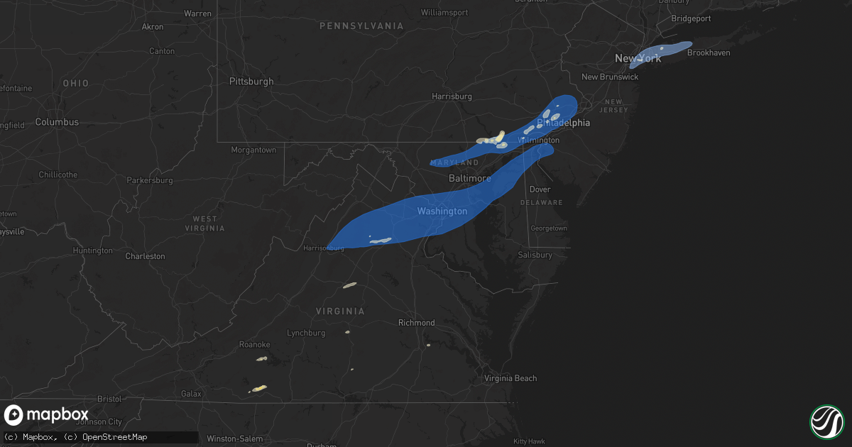
Hail Map in Maryland on June 19, 2025
Get this storm
June 19 map
$229
one time, instant access
Download today. No call, no setup
Keep the $229
Bought the map and want the full workflow? Apply the entire $229 to a subscription within 7 days. None of it is wasted.
Every map, not just this one
This buys you this map. Subscription and you get every map we run, in the markets you choose from a few cities to whole states to nationwide. Plus real-time alerts the moment a storm fires.
Contact data
Name, contact info, occupancy, even credit band for addresses in the footprint. You go from where it hit to who to call.
Become the source they trust
Unlimited branding weather history reports on demand. You already have the documented answer ready for the property owner, and you are the one who showed up with it.
Property data and RoofTrace estimates
Pull up any address you have got, its value and the exact code rules for that jurisdiction, straight from One Click Code. Then RoofTrace estimates the squares, pitch, and roof value, priced the way you price.
Storm reports in Maryland
Maryland
| Date | Description |
|---|---|
| 06/19/20256:30 PM CDT | Tree fell down along castle hill rd. |
| 06/19/20256:28 PM CDT | Tree fell across forest lane. |
| 06/19/20256:17 PM CDT | Tree fell across wallace taylor rd. |
| 06/19/20256:12 PM CDT | Trees and branches fell on powerlines across brownstone rd. |
| 06/19/20256:10 PM CDT | Tree fell across old princess anne rd. |
| 06/19/20256:08 PM CDT | Multiple trees down along anderson rd. |
| 06/19/20256:05 PM CDT | A tree fell down along silver ln. |
| 06/19/20256:05 PM CDT | Trees fell down on powerlines and caused them to catch fire. |
| 06/19/20255:55 PM CDT | Tree down along henry cross rd. |
| 06/19/20254:40 PM CDT | Multiple trees down at sudlersville cemetery road and higman mill road. Time estimated from radar. |
| 06/19/20254:40 PM CDT | Multiple trees down at sudlersville cemetery road and higman mill road. Time estimated from radar. |
| 06/19/20254:30 PM CDT | Tree on wires at broad and 4th street. Time estimated from radar. |
| 06/19/20254:30 PM CDT | Tree on wires at broad and 4th street. Time estimated from radar. |
| 06/19/20254:27 PM CDT | Large tree limbs downed. |
| 06/19/20254:25 PM CDT | Over a dozen reports of downed trees across southern cecil county from the second round of storms that came through. |
| 06/19/20254:25 PM CDT | Tree down near intersection of fairground road and bel alton newtown road. |
| 06/19/20254:25 PM CDT | Over a dozen reports of downed trees across southern cecil county from the second round of storms that came thr |
| 06/19/20254:23 PM CDT | Tree down. Time estimated from radar. |
| 06/19/20254:20 PM CDT | Tree with wires down at double creek rd and evergreen farm ln and mcginnes rd. Time estimated from radar. |
| 06/19/20254:20 PM CDT | Multiple trees with wires down along 4h park rd between john brown rd... White house ln... And tilghman neck. Time estimated from radar. |
| 06/19/20254:20 PM CDT | Multiple trees with wires down along 4h park rd between john brown rd... White house ln... And tilghman neck. Time estimated from radar. |
| 06/19/20254:11 PM CDT | Eight reports of trees down across northern calvert county. |
| 06/19/20254:10 PM CDT | Several trees uprooted. Time estimated from radar. |
| 06/19/20254:09 PM CDT | Tree with wires down-love point rd. Near kent island high school. Time estimated from radar. |
| 06/19/20254:09 PM CDT | Tree with wires down-love point rd. Near kent island high school. Time estimated from radar. |
| 06/19/20254:06 PM CDT | Trees down across road and on power lines on bayard rd & s polling house rd. |
| 06/19/20254:02 PM CDT | Corrects previous tstm wnd dmg report from 1 ssw arnold. Trees down across road and on power lines on severn way & grandview rd. |
| 06/19/20254:02 PM CDT | Trees down across road and on power lines on severn way & grandview rd. |
| 06/19/20253:57 PM CDT | Trees down blocking the roadway at virginia ave & our pl. |
| 06/19/20253:57 PM CDT | Trees and wires down... Fully blocked roadway at hazel trail & kyle rd. |
| 06/19/20253:52 PM CDT | Trees down on roadway at willow tree dr & high oak rd. |
| 06/19/20253:52 PM CDT | Trees down in roadway... Fully blocked at drum ave n & christy rd. |
| 06/19/20253:51 PM CDT | Trees and wires down with roadway closed on arundel beach road and woodland road. |
| 06/19/20253:50 PM CDT | Several tree branches down near intersection of 4th avenue and crain hwy |
| 06/19/20253:50 PM CDT | Trees blew down on md-2 governor ritchie highway at cypress cove road. |
| 06/19/20253:50 PM CDT | Trees blew down on md-43 white marsh boulevard at perry hall boulevard. |
| 06/19/20253:50 PM CDT | Five trees blew down near the intersection of chesterfield road and hawkins road. |
| 06/19/20253:48 PM CDT | Tree down and pole split in half on evergreen road at oak view drive. |
| 06/19/20253:47 PM CDT | Tree fell onto house causing some structural damage to the corner of the house on walnut trail at n riverside dr. |
| 06/19/20253:45 PM CDT | Trees blew down on md-424 davidsonville road at governor bridge road. |
| 06/19/20253:43 PM CDT | Large branches reported down on central ave near paxtuent river road. |
| 06/19/20253:40 PM CDT | Numerous trees blew down near the interchange of us-301 crain highway and md-214 central avenue. |
| 06/19/20253:40 PM CDT | Nws storm survey confirmed an ef-0 tornado briefly touched down in odenton... Md at approximately 440 pm... With peak winds estimated at 80mph. Path length was 0.1 mile |
| 06/19/20253:40 PM CDT | Over a dozen reports of trees down across the northern portion of cecil county from the first storm that came through. |
| 06/19/20253:40 PM CDT | Trees blew down on md-197 collington road near us-301 crain highway. |
| 06/19/20253:40 PM CDT | Trees blew down on md-4 pennsylvania avenue between md-980d ritchie marlboro road and old crain highway. |
| 06/19/20253:40 PM CDT | Trees blew down on southbound us-301 crain highway at leeland road. |
| 06/19/20253:35 PM CDT | Trees blew down on md-193 enterprise road at chantilly lane. |
| 06/19/20253:35 PM CDT | Trees blew down on us-50 john hanson highway at md-197 collington road. |
| 06/19/20253:34 PM CDT | Tree down at the intersection suitland parkway and naylor road. |
| 06/19/20253:34 PM CDT | Westbound suitland pkwy at naylor rd closed due to trees down blocking highway. |
| 06/19/20253:34 PM CDT | Tree down on a road in bowie |
| 06/19/20253:30 PM CDT | Trees blew down on southbound us-29 at exit 25a/southbound i-70. Trees blew down on md-144 frederick road at starhill lane. |
| 06/19/20253:26 PM CDT | Numerous trees and wires down across silver spring |
| 06/19/20253:25 PM CDT | Trees blew down near the intersection of suitland parkway and md-5 branch avenue. |
| 06/19/20253:25 PM CDT | A wind gust of 51 knots |
| 06/19/20253:24 PM CDT | Tree on a house at the 1600 noyes dr near 2nd ave |
| 06/19/20253:24 PM CDT | Tree down in 5900 block of river road. |
| 06/19/20253:20 PM CDT | Tree on a house at the 11300 block of palisades ct |
| 06/19/20253:20 PM CDT | Trees and wires down on a vehicle |
| 06/19/20253:20 PM CDT | Trees and wires down |
| 06/19/20253:20 PM CDT | Wires down at the 3600 block of spurell ct. |
| 06/19/20253:20 PM CDT | Tree on a house at the 7900 block of tacoma ave |
| 06/19/20253:20 PM CDT | Trees blew down on us-29 columbia pike near industrial parkway. |
| 06/19/20253:20 PM CDT | Large tree down at the 1620 block of western ave |
| 06/19/20253:19 PM CDT | Several small branches... Around 2 inches in diameter... Down in the area |
| 06/19/20253:18 PM CDT | Tree down on a house. |
| 06/19/20253:16 PM CDT | Tree on a house at the 6200 block of vorlich ln |
| 06/19/20253:15 PM CDT | Trees and large tree limbs blew down onto power lines in silver spring. |
| 06/19/20253:15 PM CDT | A tree blew down onto a house in the 1600 block of noyes drive |
| 06/19/20253:15 PM CDT | A tree blew down onto a house in the 7900 block of takoma avenue. |
| 06/19/20253:15 PM CDT | Trees blew down on eastbound i-495 capital beltway inner loop at md-355 wisconsin avenue/rockville pike. |
| 06/19/20253:15 PM CDT | Trees blew down on md-646 prospect road at bay road. |
| 06/19/20253:15 PM CDT | Trees blew down on eastbound i-495 capital beltway inner loop at exit 33/md-185 connecticut avenue... And on westbound i-495 capital betlway outer loop at exit 36/md-18 |
| 06/19/20253:15 PM CDT | A large tree blew down onto a metro bus near the intersection of md-410 east-west highway and md-185 connecticut avenue. |
| 06/19/20253:15 PM CDT | Trees blew down on md-543 ady road at walters mill road. |
| 06/19/20253:14 PM CDT | Right lane of clara barton pkwy heading toward i-495 closed due to a tree down |
| 06/19/20253:14 PM CDT | Trees and wires down |
| 06/19/20253:10 PM CDT | A tree blew down onto a house in the 11000 block of home place lane. |
| 06/19/20253:10 PM CDT | Trees blew down on southbound i-83 at exit 18/md-943 warren road. |
| 06/19/20253:10 PM CDT | Part of clara barton parkway is blocked by a tree in the direction of i-495. |
| 06/19/20253:07 PM CDT | Numerous reports of trees reported down in the jarrettsville area. |
| 06/19/20253:07 PM CDT | National park service reports that the entrance to great fall national park maryland side is blocked by trees. |
| 06/19/20253:05 PM CDT | Numerous large trees blew down along md-190 river road between falls road and i-495 capital beltway. |
| 06/19/20253:05 PM CDT | Trees blew down on southbound i-495 capital beltway outer loop after md-190 river road. |
| 06/19/20253:05 PM CDT | Trees blew down on eastbound clara barton parkway near i-495 capital beltway. |
| 06/19/20253:00 PM CDT | Trees blew down near the intersection of md-23 norrisville road and white hall road. |
| 06/19/20253:00 PM CDT | Trees blew down on md-146 jarrettsville pike at dulaney valley road. |
| 06/19/20252:59 PM CDT | Trees and wires down at whites ferry rd at darnestown rd |
| 06/19/20252:55 PM CDT | Trees blew down on md-45 york road at gifford lane. |
| 06/19/20252:53 PM CDT | Few large trees down onto roadway near intersection of md rt 26 and klee mill rd |
| 06/19/20252:45 PM CDT | Numerous trees blew down along md-25 falls road near knox avenue and shawan road. |
| 06/19/20252:45 PM CDT | Trees blew down on md-25 falls road near benson mill road. |
| 06/19/20252:45 PM CDT | Trees blew down on md-25 falls road at md-88 black rock road. |
| 06/19/20252:45 PM CDT | Trees blew down on md-25 falls road near benso district of columbdc 3888 7703 tree reported down on ohio drive between buckeye drive and golf course entranc |
| 06/19/20252:40 PM CDT | Trees blew down on md-91 emory road at springhurst court. |
| 06/19/20252:29 PM CDT | Large trees blew down along va-407 marston road. |
| 06/19/20252:29 PM CDT | Large trees blew down along va-407 marston |
| 06/19/20252:25 PM CDT | Multiple large tree limbs snapped along watersville road. |
| 06/19/20252:25 PM CDT | Numerous trees blew down along md-26 liberty road between franklinville road and woodbine road. |
| 06/19/20252:23 PM CDT | A couple trees down in adamstown. |
| 06/19/20252:15 PM CDT | Reports of multiple trees down in new market. |
| 06/19/20252:05 PM CDT | Reports of multiple trees down in frederick. |
| 06/19/20252:00 PM CDT | Multiple reports of trees down in jefferson area of frederick county. |
| 06/19/20252:00 PM CDT | Trees blew down on us-40 alternate/old national pike at south clifton road. |
| 06/19/20251:54 PM CDT | A couple calls for trees down in myersville and middletown. |
| 06/19/20251:54 PM CDT | A couple calls for trees down in myersville and middletown. |
| 06/19/20251:50 PM CDT | Trees blew down on petersville road at burkittsville road. N rd |
| 06/19/20251:50 PM CDT | Trees blew down on petersville road at burkittsville road. |
| 06/19/20251:46 PM CDT | Tree reported down near the intersection of washington street and mcdowell street. |
| 06/19/20251:45 PM CDT | Trees blew down on us-340 at keep tryst road. |
| 06/19/20251:03 PM CDT | Tree down onto wires near 14123 clear spring rd |
All States Impacted by Hail Map on June 19, 2025
Cities Impacted by Hail Map on June 19, 2025
- Hernando, MS
- Coldwater, MS
- Senatobia, MS
- Tupelo, MS
- Pontotoc, MS
- Sarah, MS
- Como, MS
- Sledge, MS
- Dundee, MS
- Coahoma, MS
- Crenshaw, MS
- Sardis, MS
- Batesville, MS
- Marks, MS
- Pope, MS
- Courtland, MS
- Lambert, MS
- Enid, MS
- Riceville, IA
- Chester, IA
- Clarksdale, MS
- Friars Point, MS
- Helena, AR
- Alligator, MS
- Duck Hill, MS
- Crumrod, AR
- Duncan, MS
- Snow Lake, AR
- Dunnellon, FL
- Gunnison, MS
- Ocala, FL
- Shelby, MS
- Watson, AR
- Rosedale, MS
- Redfield, AR
- England, AR
- Tucker, AR
- Sherrill, AR
- Hensley, AR
- Beulah, MS
- Boones Mill, VA
- Ponce De Leon, FL
- Jefferson, AR
- Benoit, MS
- Sheridan, AR
- Hardy, VA
- Wirtz, VA
- Rocky Mount, VA
- Lenoir, NC
- Vernon, FL
- White Hall, AR
- Greenville, MS
- Rohwer, AR
- Collinsville, VA
- Martinsville, VA
- Taylorsville, NC
- Moravian Falls, NC
- Fieldale, VA
- Basking Ridge, NJ
- Far Hills, NJ
- Lutz, FL
- Tampa, FL
- Pine Bluff, AR
- Elkton, VA
- McGaheysville, VA
- Harrisonburg, VA
- Keezletown, VA
- Shenandoah, VA
- New Market, VA
- Broadway, VA
- Stanley, VA
- Etlan, VA
- Syria, VA
- Banco, VA
- Madison, VA
- Grady, AR
- Stanfordville, NY
- Clinton Corners, NY
- Valparaiso, FL
- Eglin Afb, FL
- Yorktown, AR
- Reva, VA
- Boston, VA
- Culpeper, VA
- Amenia, NY
- Pine Plains, NY
- Oakville, CT
- Castleton, VA
- Woodville, VA
- Millerton, NY
- Norman, AR
- Bonnerdale, AR
- Waterbury, CT
- Thomaston, CT
- Middlebury, CT
- Watertown, CT
- Short Hills, NJ
- South Orange, NJ
- Millburn, NJ
- Springfield, NJ
- Vauxhall, NJ
- Maplewood, NJ
- Terryville, CT
- Plymouth, CT
- Bristol, CT
- Burlington, CT
- Grapevine, AR
- Lebanon, NJ
- Whitehouse Station, NJ
- Plant City, FL
- Annandale, NJ
- Defuniak Springs, FL
- Niceville, FL
- Brandy Station, VA
- Wolcott, CT
- Newark, NJ
- Irvington, NJ
- Amissville, VA
- Troy, AL
- Luray, VA
- Sperryville, VA
- Haywood, VA
- Rixeyville, VA
- Rileyville, VA
- Bentonville, VA
- Washington, VA
- Huntly, VA
- Marshall, VA
- Flint Hill, VA
- Warrenton, VA
- Hume, VA
- Remington, VA
- Jeffersonton, VA
- Chester Gap, VA
- Markham, VA
- Catharpin, VA
- Delaplane, VA
- Chantilly, VA
- Broad Run, VA
- Centreville, VA
- Haymarket, VA
- Elkwood, VA
- Linden, VA
- Gainesville, VA
- Manassas, VA
- Nokesville, VA
- Bealeton, VA
- Midland, VA
- Catlett, VA
- The Plains, VA
- Bristow, VA
- Little River, AL
- Ariton, AL
- Elkton, FL
- Sharon, CT
- Belzoni, MS
- Marshallville, GA
- Front Royal, VA
- Aldie, VA
- Upperville, VA
- Middleburg, VA
- Goldvein, VA
- Sumerduck, VA
- Herndon, VA
- Sterling, VA
- Ashburn, VA
- Clifton, VA
- Triangle, VA
- Fairfax Station, VA
- Woodbridge, VA
- Fairfax, VA
- Quantico, VA
- Stafford, VA
- Dumfries, VA
- McLean, VA
- Reston, VA
- Great Falls, VA
- Burke, VA
- Springfield, VA
- Vienna, VA
- Oakton, VA
- Annandale, VA
- Leesburg, VA
- Lorton, VA
- Potomac, MD
- Gaithersburg, MD
- Germantown, MD
- Poolesville, MD
- Occoquan, VA
- Rockville, MD
- Marbury, MD
- Bethesda, MD
- Accokeek, MD
- La Plata, MD
- Arlington, VA
- Dunn Loring, VA
- Falls Church, VA
- Cabin John, MD
- Alexandria, VA
- Indian Head, MD
- Fort Belvoir, VA
- Bryans Road, MD
- Hazelhurst, WI
- Minocqua, WI
- Dillwyn, VA
- Farmville, VA
- Hiddenite, NC
- Union Grove, NC
- Saint Augustine, FL
- Nanjemoy, MD
- Elba, AL
- Fredericksburg, VA
- Port Tobacco, MD
- White Plains, MD
- Waldorf, MD
- Pomfret, MD
- Union Bridge, MD
- Mount Airy, MD
- New Windsor, MD
- Woodbine, MD
- Sykesville, MD
- Westminster, MD
- Reisterstown, MD
- Finksburg, MD
- Hampstead, MD
- Upperco, MD
- Glyndon, MD
- Owings Mills, MD
- Cockeysville, MD
- Parkton, MD
- Sparks Glencoe, MD
- Monkton, MD
- Phoenix, MD
- Jarrettsville, MD
- Forest Hill, MD
- Baldwin, MD
- Fallston, MD
- White Hall, MD
- Street, MD
- Pylesville, MD
- Whiteford, MD
- Delta, PA
- Fawn Grove, PA
- Chevy Chase, MD
- Fort Washington, MD
- Fort Myer, VA
- Glen Echo, MD
- Derwood, MD
- Washington, DC
- Lake Tomahawk, WI
- Charlottesville, VA
- Caddo Gap, AR
- Donalsonville, GA
- Hamptonville, NC
- North Wilkesboro, NC
- Plainfield, NJ
- Watchung, NJ
- Dunellen, NJ
- Lizella, GA
- Macon, GA
- Statesville, NC
- Summit, NJ
- Brandywine, MD
- Clinton, MD
- Oxon Hill, MD
- Temple Hills, MD
- Silver Spring, MD
- Bryantown, MD
- Garrett Park, MD
- Naval Anacost Annex, DC
- Kensington, MD
- Greenbelt, MD
- Capitol Heights, MD
- Riverdale, MD
- Annapolis Junction, MD
- Andrews Air Force Base, MD
- Savage, MD
- Laurel, MD
- Brentwood, MD
- Burtonsville, MD
- Jessup, MD
- Fort George G Meade, MD
- Lanham, MD
- Bowie, MD
- Sandy Spring, MD
- College Park, MD
- Glenn Dale, MD
- Suitland, MD
- Beltsville, MD
- Bladensburg, MD
- Ashton, MD
- Cheltenham, MD
- District Heights, MD
- Fulton, MD
- Takoma Park, MD
- Columbia, MD
- Mount Rainier, MD
- Spencerville, MD
- Hyattsville, MD
- Olney, MD
- Upper Marlboro, MD
- Bel Air, MD
- Darlington, MD
- Drumore, PA
- Peach Bottom, PA
- Rising Sun, MD
- Conowingo, MD
- Oxford, PA
- Port Deposit, MD
- Nottingham, PA
- Kirkwood, PA
- Colora, MD
- North East, MD
- Quarryville, PA
- Rison, AR
- Mount Ida, AR
- Jack, AL
- Airville, PA
- New Park, PA
- Olin, NC
- Union, NJ
- Adel, GA
- Harmony, NC
- Scotch Plains, NJ
- Fanwood, NJ
- Churchville, MD
- Havre De Grace, MD
- Perryville, MD
- Elkton, MD
- Lincoln University, PA
- Cochranville, PA
- Wilmot, NH
- Danbury, NH
- Opp, AL
- Deltona, FL
- Osteen, FL
- Keswick, VA
- McKenzie, AL
- Staten Island, NY
- Jersey City, NJ
- Bayonne, NJ
- New York, NY
- Brooklyn, NY
- Flushing, NY
- Elmhurst, NY
- East Elmhurst, NY
- Astoria, NY
- Ozone Park, NY
- Middle Village, NY
- Kew Gardens, NY
- Ridgewood, NY
- Maspeth, NY
- Sunnyside, NY
- Woodhaven, NY
- South Richmond Hill, NY
- Long Island City, NY
- Forest Hills, NY
- Corona, NY
- Richmond Hill, NY
- Woodside, NY
- Jackson Heights, NY
- Rego Park, NY
- Newark, DE
- Landenberg, PA
- West Grove, PA
- Avondale, PA
- Coatesville, PA
- Hockessin, DE
- West Chester, PA
- Kennett Square, PA
- Toughkenamon, PA
- Harwood, MD
- Deale, MD
- Crofton, MD
- West River, MD
- Gambrills, MD
- Odenton, MD
- Owings, MD
- Lothian, MD
- Friendship, MD
- Tracys Landing, MD
- Dunkirk, MD
- Davidsonville, MD
- Harmans, MD
- Glen Burnie, MD
- Hanover, MD
- Crownsville, MD
- Edgewater, MD
- Severna Park, MD
- Arnold, MD
- Riva, MD
- Pasadena, MD
- Galesville, MD
- Shady Side, MD
- Churchton, MD
- Millersville, MD
- Annapolis, MD
- Severn, MD
- Gibson Island, MD
- Springfield, NH
- Wilmington, DE
- Chadds Ford, PA
- Yorklyn, DE
- Geneva, FL
- Valparaiso, IN
- Chesterton, IN
- New Edinburg, AR
- Oden, AR
- Kinston, AL
- Langley, AR
- Portage, IN
- Wilmar, AR
- Florala, AL
- Foxworth, MS
- Kokomo, MS
- Hill, NH
- New Smyrna Beach, FL
- Rockland, DE
- Montchanin, DE
- Bronx, NY
- Hoboken, NJ
- Jamaica, NY
- College Point, NY
- Whitestone, NY
- Bellerose, NY
- Oakland Gardens, NY
- Queens Village, NY
- Hollis, NY
- Fresh Meadows, NY
- Bayside, NY
- Thornton, PA
- Marcus Hook, PA
- Garnet Valley, PA
- Claymont, DE
- Glen Mills, PA
- Chester Heights, PA
- Chester, PA
- Aston, PA
- Wallingford, PA
- Brookhaven, PA
- Newtown Square, PA
- Media, PA
- Cheyney, PA
- Bristol, NH
- Claiborne, MD
- Stevensville, MD
- Saint Michaels, MD
- Wittman, MD
- Easton, MD
- Chester, MD
- Mcdaniel, MD
- Grasonville, MD
- Queenstown, MD
- Rock Hall, MD
- Chestertown, MD
- Wye Mills, MD
- Centreville, MD
- Fort Howard, MD
- Curtis Bay, MD
- Sparrows Point, MD
- Worton, MD
- Still Pond, MD
- Galena, MD
- Earleville, MD
- Sudlersville, MD
- Kennedyville, MD
- Church Hill, MD
- Warwick, MD
- Millington, MD
- Cordova, MD
- Queen Anne, MD
- Crumpton, MD
- Georgetown, MD
- Little Neck, NY
- Garden City, NY
- Great Neck, NY
- Floral Park, NY
- New Hyde Park, NY
- Glen Oaks, NY
- Roslyn, NY
- Carle Place, NY
- Manhasset, NY
- Roslyn Heights, NY
- Albertson, NY
- Williston Park, NY
- Hicksville, NY
- Levittown, NY
- Old Westbury, NY
- Westbury, NY
- Mineola, NY
- East Meadow, NY
- Old Bethpage, NY
- Greenvale, NY
- Glenwood Landing, NY
- Melville, NY
- Syosset, NY
- Bethpage, NY
- Jericho, NY
- Port Washington, NY
- Glen Head, NY
- Plainview, NY
- Sea Cliff, NY
- Glen Cove, NY
- Locust Valley, NY
- Mill Neck, NY
- East Norwich, NY
- Oyster Bay, NY
- Woodbury, NY
- Huntington, NY
- Farmingdale, NY
- Pearl River, LA
- Samson, AL
- Trinidad, CO
- Model, CO
- Moss Point, MS
- Winston Salem, NC
- Lewisville, NC
- Warren, AR
- Columbia, MS
- Clemmons, NC
- Swarthmore, PA
- Crum Lynne, PA
- Woodlyn, PA
- Broomall, PA
- Folcroft, PA
- Clifton Heights, PA
- Springfield, PA
- Norwood, PA
- Prospect Park, PA
- Folsom, PA
- Morton, PA
- Glenolden, PA
- Holmes, PA
- Ridley Park, PA
- Sharon Hill, PA
- Drexel Hill, PA
- Bala Cynwyd, PA
- Gladwyne, PA
- Havertown, PA
- Merion Station, PA
- Haverford, PA
- Wynnewood, PA
- Philadelphia, PA
- Bryn Mawr, PA
- Lansdowne, PA
- Narberth, PA
- Upper Darby, PA
- Ardmore, PA
- Darby, PA
- Essex, MD
- Gunpowder, MD
- Betterton, MD
- Ridgely, MD
- Barclay, MD
- Goldsboro, MD
- Chesapeake City, MD
- Denton, MD
- Henderson, MD
- Greensboro, MD
- Ingleside, MD
- Cecilton, MD
- Massey, MD
- Marydel, MD
- Clayton, DE
- Middletown, DE
- New Castle, DE
- Townsend, DE
- Bear, DE
- Odessa, DE
- Smyrna, DE
- Wyncote, PA
- Bryn Athyn, PA
- Bensalem, PA
- Jenkintown, PA
- Cheltenham, PA
- Huntingdon Valley, PA
- Elkins Park, PA
- Feasterville Trevose, PA
- Glenside, PA
- Abington, PA
- Monticello, AR
- Tripoli, WI
- Nashville, GA
- Vancleave, MS
- Glenwood, AR
- Alva, FL
- Lehigh Acres, FL
- Millen, GA
- New Hampton, NH
- Cold Spring Harbor, NY
- Huntington Station, NY
- Centerport, NY
- Greenlawn, NY
- Kings Park, NY
- Smithtown, NY
- East Northport, NY
- Commack, NY
- Northport, NY
- Saint James, NY
- Delaware City, DE
- Saint Georges, DE
- Smithville, OK
- Chauncey, GA
- Punta Gorda, FL
- Sylvania, GA
- Watersmeet, MI
- Mena, AR
- Umpire, AR
- Douglas, GA
- Jakin, GA
- Willacoochee, GA
- Iron River, MI
- Tomahawk, WI
- Salem, NJ
- Port Penn, DE
- Pennsville, NJ
- Penns Grove, NJ
- Woodstown, NJ
- Pedricktown, NJ
- Blue Bell, PA
- Watson, OK
- Pearson, GA
- Abita Springs, LA
- Covington, LA
- Ponchatoula, LA
- Springfield, LA
- Biloxi, MS
- Diberville, MS
- Newhope, AR
- Milan, GA
- Eastman, GA
- Winona, KS
- Holly, CO
- Fort White, FL
- Ambler, PA
- Devon, PA
- Berwyn, PA
- Paoli, PA
- King Of Prussia, PA
- Wayne, PA
- Lake City, FL
- Lake Placid, FL
- Conshohocken, PA
- Colby, KS
- Boncarbo, CO
- North Fort Myers, FL
- Lawrence Township, NJ
- Long Beach, MS
- Bryant Pond, ME
- Rumford, ME
- Gulfport, MS
- Prince George, VA
- Hopewell, VA
- Norristown, PA
- Malvern, PA
- Keshena, WI
- Merrill, WI
- Wausau, WI
- Bush, LA
- Trenton, NJ
- Princeton, NJ
- Princeton Junction, NJ
- Pennington, NJ
- Bassett, NE
- Madisonville, LA
- Pass Christian, MS
- Star City, AR
- Gillett, WI
- Matawan, NJ
- Holmdel, NJ
- Hazlet, NJ
- Morganville, NJ
- Keyport, NJ
- Suring, WI
- Arkansas City, AR
- Westfield, NJ
- Big Timber, MT
- Baton Rouge, LA
- Elizabeth, NJ
- Cecil, WI
- Burwell, NE
- Keansburg, NJ
- Weston, CO
- Medora, ND
- Fairfield, ND
- Monument, KS
- Belfield, ND
- Oberlin, KS
- Loman, MN
- Littlefork, MN
- Hahira, GA
- Two Dot, MT
- Middletown, NJ
- Herrick, SD
- Burke, SD
- Big Falls, MN
- Atwood, KS
- Effie, LA
- Manson, NC
- Norlina, NC
- Warrenton, NC
- Saint Charles, SD
- Bonesteel, SD
- Herndon, KS
- Dickinson, ND
- Independence, LA
- Amite, LA
- Danbury, NE
- Husser, LA
- Fenton, MI
- Watford City, ND
- Denham Springs, LA
- Walker, LA
- Jonesville, LA
- Keysville, VA
- Chisago City, MN
- Lindstrom, MN
- Mohall, ND
- Sherwood, ND
- Macon, NC
- Oakley, KS
- South Heart, ND
- Broken Bow, OK
- Holly, MI
- Highland, MI
- Hartland, MI
- Baker, FL
- Osceola, WI
- Shafer, MN
- De Pere, WI
- Center City, MN
- Tickfaw, LA
- Antler, ND
- Raton, NM
- Star Prairie, WI
- New Richmond, WI
- Somerset, WI
- Ethel, LA
- Clinton, LA
- Killdeer, ND
- Mandaree, ND
- Greenleaf, WI
- Lebanon, NE
- Norcatur, KS
- Loranger, LA
- Atkinson, NE
- Stuart, NE
- Henderson, NC
- Middleburg, NC
- Erwinville, LA
- Baker, LA
- Slaughter, LA
- Baldwin, WI
- Hammond, WI
- Hosmer, SD
- Roscoe, SD
- Nome, ND
- Enderlin, ND
- Kathryn, ND
- Fort Ransom, ND
- Lisbon, ND
- Zachary, LA
- Linden, MI
- Bowdle, SD
- Woodville, WI
- Jennings, KS
- Lefor, ND
- Gladstone, ND
- Spring Valley, WI
- Wilson, WI
- Collettsville, NC
- Carrboro, NC
- Chapel Hill, NC
- Pride, LA
- Greenwell Springs, LA
- Reedsville, WI
- Jackson, NC
- Garysburg, NC
- Regent, ND
- Elmwood, WI
- Apex, NC
- Cary, NC
- Milnor, ND
- Conway, NC
- Valentine, TX
- Cook, MN
- Ryder, ND
- Glenwood City, WI
- Norton, KS
- Mott, ND
- Plum City, WI
- Maiden Rock, WI
- Arkansaw, WI
- Ipswich, SD
- Bennettsville, SC
- Wallace, SC
- Roseglen, ND
- Onaka, SD
- Mcleod, ND
- Wyndmere, ND
- Durham, NC
- Denhoff, ND
- Barney, ND
- Mcclusky, ND
- Mercer, ND
- Butte, ND
- Pepin, WI
- Menomonie, WI
- Nelson, WI
- Durand, WI
- Ord, NE
- Ericson, NE
- Faulkton, SD
- Glenfield, ND
- Hankinson, ND
- Mantador, ND
- Lidgerwood, ND
- Mooreton, ND
- Anamoose, ND
- Martin, ND
- Red Springs, NC
- Raeford, NC
- Goodrich, ND
- Sierra Blanca, TX
- Grassy Butte, ND
- New Leipzig, ND
- Elyria, NE
- Reads Landing, MN
- Wabasha, MN
- Alma, WI
- Fairmount, ND
- Cresbard, SD
- Harvey, ND
- Hurdsfield, ND
- Kellogg, MN
- Driscoll, ND
- Chaseley, ND
- Mansfield, SD
- Northville, SD
- Columbus, NE
- Altura, MN
- North Loup, NE
- Minnesota City, MN
- Cochrane, WI
- Rockham, SD
- Ashton, SD
- Rosholt, SD
- Tintah, MN
- Wheaton, MN
- Steele, ND
- Fessenden, ND
- Bowdon, ND
- Doland, SD
- McColl, SC
- Gibson, NC
- Sykeston, ND
- Cathay, ND
- Turton, SD
- Scotia, NE
- Rollingstone, MN
- Mellette, SD
- Braddock, ND
- Fairchild, WI
- Osseo, WI
- Redfield, SD
- Aberdeen, SD
- Carson, ND
- Dawson, ND
- Clark, SD
- Brentford, SD
- Conde, SD
- Wahpeton, ND
- Ashton, NE
- Stratford, SD
- Humbird, WI
- Merrillan, WI
- Willow Lake, SD
- Warner, SD
- Elba, NE
- Loup City, NE
- Donnelly, MN
- Dumont, MN
- Chokio, MN
- Page, ND
- Woodworth, ND
- Selfridge, ND
- Pingree, ND
- Tappen, ND
- Carrington, ND
- Raymond, SD
- Bryant, SD
- Farwell, NE
- Erie, ND
- Ayr, ND
- Parshall, ND
- Napoleon, ND
- Garden City, SD
- Seaboard, NC
- Gackle, ND
- Saint Paul, NE
- Frankfort, SD
- Carpenter, SD
- Goldsboro, NC
- Elgin, ND
- Amenia, ND
- Horsham, PA
- Montgomeryville, PA
- Southampton, PA
- Lansdale, PA
- Chalfont, PA
- Jamison, PA
- North Wales, PA
- Doylestown, PA
- Willow Grove, PA
- Hatboro, PA
- Warminster, PA
- Richboro, PA
- Warrington, PA
- Furlong, PA
- Flourtown, PA
- Gwynedd, PA
- Fort Washington, PA
- Phoenixville, PA
- Spring House, PA
- Dresher, PA
- Oreland, PA
- Plymouth Meeting, PA
- Bridgeport, PA
- Collegeville, PA
- Lafayette Hill, PA
- Villanova, PA
- Newtown, PA
- Langhorne, PA
- Lehr, ND
- Fredonia, ND
- Vienna, SD
- Pipestone, MN
- Castlewood, SD
- Hayti, SD
- Lake Norden, SD
- David City, NE
- Ruthton, MN
- Wolbach, NE
- Henry, SD
- Appleton, MN
- Hazel, SD
- Danvers, MN
- Dwight, NE
- Brainard, NE
- Watertown, SD
- Montevideo, MN
- Estelline, SD
- Valparaiso, NE
- Weston, NE
- Milan, MN
- Ceresco, NE
- Arlington, SD
- Erwin, SD
- Badger, SD
- Moorhead, MN
- Dallas Center, IA
- Wahoo, NE
- Palmer, NE
- Raymond, NE
- Marshfield, WI
- Stratford, WI
- Clear Lake, SD
- Rushmore, MN
- Horace, ND
- Maynard, MN
- Clara City, MN
- Bruce, SD
- Brookings, SD
- Toronto, SD
- Grimes, IA
- Waukee, IA
- Waverly, NE
- Ashland, NE
- Tyler, MN
- Wolverton, MN
- Greenwood, NE
- Davey, NE
- Ithaca, NE
- Lincoln, NE
- Comstock, MN
- Sabin, MN
- Christine, ND
- Barnesville, MN
- Walcott, ND
- Colfax, ND
- Kent, MN
- Abercrombie, ND
- Breckenridge, MN
- Rothsay, MN
- Fergus Falls, MN
- White, SD
- Aurora, SD
- Volga, SD
- Astoria, SD
- Elkton, SD
- Hendricks, MN
- Sheldon, WI
- Conrath, WI
- Ladysmith, WI
- Franklin, MN
- Morton, MN
- Redwood Falls, MN
- Groton, SD
- Brandt, SD
- Crofton, NE
- Alvo, NE
- Avoca, NE
- Weeping Water, NE
- Elmwood, NE
- Murdock, NE
- Plattsmouth, NE
- South Bend, NE
- Springfield, NE
- Gretna, NE
- Murray, NE
- Memphis, NE
- Nehawka, NE
- Louisville, NE
- Manley, NE
- Yutan, NE
- Cedar Creek, NE
- Andover, SD
- Gilman, WI
- Slayton, MN
- Lake Wilson, MN
- Holcombe, WI
- Lake Benton, MN
- Fordyce, NE
- Renville, MN
- Foxhome, MN
- Campbell, MN
- Dalton, MN
- Underwood, MN
- Ivanhoe, MN
- Arco, MN
- Currie, MN
- Avoca, MN
- Pierpont, SD
- Danube, MN
- Webster, SD
- Saint Helena, NE
- Forest City, IA
- Tony, WI
- Lublin, WI
- Withee, WI
- Elbow Lake, MN
- Wendell, MN
- Battle Lake, MN
- Ashby, MN
- Union, NE
- Balaton, MN
- Holland, MN
- Westbrook, MN
- Dovray, MN
- Fulda, MN
- Russell, MN
- Bristol, SD
- Heron Lake, MN
- Windom, MN
- Evansville, MN
- Thurman, IA
- Percival, IA
- Pacific Junction, IA
- Garvin, MN
- Sidney, IA
- Tabor, IA
- Farragut, IA
- Imogene, IA
- Brandon, MN
- Alexandria, MN
- Garfield, MN
- Estherville, IA
- Dolliver, IA
- Randolph, IA
- Shenandoah, IA
- Hawkins, WI
- Kennan, WI
- Nelson, MN
- Osakis, MN
- Armstrong, IA
- Essex, IA
- Farwell, MN
- Westboro, WI
- Medford, WI
- Villard, MN
- Sauk Centre, MN
- West Union, MN
- Coin, IA
- Carlos, MN
- Correll, MN
- Clarinda, IA
- Dunnell, MN
- Ceylon, MN
- Yorktown, IA
- Jackson, MN
- Sherburn, MN
- Alpha, MN
- Spirit Lake, IA
- Superior, IA
- Graettinger, IA
- Emmetsburg, IA
- Wallingford, IA
- Swea City, IA
- Glenwood, IA
- Malvern, IA
- College Springs, IA
- Riverton, IA
- Braddyville, IA
- Blanchard, IA
- Shambaugh, IA
- Northboro, IA
- Ringsted, IA
- Fenton, IA
- Bancroft, IA
- Lone Rock, IA
- Melrose, MN
- Thorp, WI
- Freeport, MN
- Burt, IA
- Algona, IA
- Raymond, MN
- Whittemore, IA
- Murdock, MN
- Benson, MN
- Albany, MN
- Kerkhoven, MN
- Pennock, MN
- Wesley, IA
- Bode, IA
- West Bend, IA
- Lu Verne, IA
- Garner, IA
- Cylinder, IA
- Corwith, IA
- Livermore, IA
- Ottosen, IA
- Cold Spring, MN
- Saint Cloud, MN
- Kanawha, IA
- Renwick, IA
- Goldfield, IA
- Clarion, IA
- Rowan, IA
- Belmond, IA
- Rutland, IA
- Eagle Grove, IA
- Thor, IA
- Hardy, IA
- Humboldt, IA
- Britt, IA
- Swaledale, IA
- Alexander, IA
- Goodell, IA
- Thornton, IA
- Klemme, IA
- Meservey, IA
- Sheffield, IA
- Kimball, MN
- South Haven, MN
- Clearwater, MN
- Fairfax, MN
- Gibbon, MN
- Winthrop, MN
- Dexter, IA
- Winterset, IA
- Stuart, IA
- Greenfield, IA
- Lafayette, MN
- Dakota City, IA
- Latimer, IA
- Woolstock, IA
- Vincent, IA
- Alden, IA
- Williams, IA
- Galt, IA
- Blairsburg, IA
- Coulter, IA
- Iowa Falls, IA
- Dows, IA
- Hampton, IA
- Ackley, IA
- Bradford, IA
- Geneva, IA
- Hector, MN
- Saint Peter, MN
- Stewart, MN
- Buffalo Lake, MN
- Gaylord, MN
- Webster City, IA
- Nicollet, MN
- Westside, IA
- Carroll, IA
- Arcadia, IA
- Eldora, IA
- Steamboat Rock, IA
- Kamrar, IA
- Albion, IA
- Liscomb, IA
- Ellsworth, IA
- Union, IA
- Le Sueur, MN
- Glidden, IA
- Coon Rapids, IA
- Hubbard, IA
- Conrad, IA
- Saint Anthony, IA
- Clemons, IA
- Radcliffe, IA
- Jewell, IA
- Buffalo Center, IA
- Grundy Center, IA
- New Providence, IA
- Marshalltown, IA
- Guthrie Center, IA
- Lakota, IA
- Scranton, IA
- Beaman, IA
- Whitten, IA
- Story City, IA
- Cleveland, MN
- Kasota, MN
- Zearing, IA
- McCallsburg, IA
- Garden City, IA
- Gladbrook, IA
- Gowrie, IA
- Nevada, IA
- Yale, IA
- Bagley, IA
- Jefferson, IA
- Jamaica, IA
- Madison Lake, MN
- Churdan, IA
- Farnhamville, IA
- Lohrville, IA
- Roland, IA
- Ralston, IA
- Elysian, MN
- Thompson, IA
- State Center, IA
- Colo, IA
- Gilman, IA
- Panora, IA
- Paton, IA
- Leland, IA
- Ventura, IA
- Fertile, IA
- Clear Lake, IA
- Janesville, MN
- Mason City, IA
- Linden, IA
- Dawson, IA
- Melbourne, IA
- Le Grand, IA
- Haverhill, IA
- Perry, IA
- Minburn, IA
- Rockwell, IA
- Rhodes, IA
- Rippey, IA
- Collins, IA
- Redfield, IA
- Ogden, IA
- Adel, IA
- Baxter, IA
- Ferguson, IA
- Earlham, IA
- Hanlontown, IA
- Bouton, IA
- Grand Junction, IA
- Dana, IA
- Dougherty, IA
- Van Meter, IA
- Northwood, IA
- Boone, IA
- Woodward, IA
- Urbandale, IA
- Clive, IA
- Madrid, IA
- Booneville, IA
- Granger, IA
- Marble Rock, IA
- Greene, IA
- Rockford, IA
- Norcross, MN
- Herman, MN
- Woden, IA
- Titonka, IA


