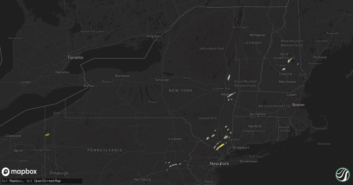
Hail Map in New York on June 19, 2017
Get this storm
June 19 map
$229
one time, instant access
Download today. No call, no setup
Keep the $229
Bought the map and want the full workflow? Apply the entire $229 to a subscription within 7 days. None of it is wasted.
Every map, not just this one
This buys you this map. Subscription and you get every map we run, in the markets you choose from a few cities to whole states to nationwide. Plus real-time alerts the moment a storm fires.
Contact data
Name, contact info, occupancy, even credit band for addresses in the footprint. You go from where it hit to who to call.
Become the source they trust
Unlimited branding weather history reports on demand. You already have the documented answer ready for the property owner, and you are the one who showed up with it.
Property data and RoofTrace estimates
Pull up any address you have got, its value and the exact code rules for that jurisdiction, straight from One Click Code. Then RoofTrace estimates the squares, pitch, and roof value, priced the way you price.
Storm reports in New York
New York
| Date | Description |
|---|---|
| 06/19/20174:45 PM CDT | Tree fell on the road in forest hills |
| 06/19/20174:37 PM CDT | Tree fell onto home |
| 06/19/20174:24 PM CDT | Downed tree on the palisades parkway northbound between exits 13 and 14 |
| 06/19/20174:00 PM CDT | Tree fell on a car at w 78th street between amsterdam and columbus |
| 06/19/20173:56 PM CDT | Tree split in half and blocking street at w167 street and woodycrest aveneu |
| 06/19/20173:56 PM CDT | Tree split in half and blocking street at w167 street and woodycrest aveneu |
| 06/19/20173:48 PM CDT | Tree branch blocking two lanes going westbound at 360 west 34th street |
| 06/19/20173:40 PM CDT | Road closed due to a tree down in the area of tinkertown road and e/w state hwy 343 |
| 06/19/20173:36 PM CDT | Many trees and wires down on drewville road |
| 06/19/20173:33 PM CDT | Tree down on route 312. |
| 06/19/20173:07 PM CDT | Wires down in the town of hillsdale. |
| 06/19/20173:07 PM CDT | Road closed due to a tree down in the area of tinkertown road and e/w state hwy 343 |
| 06/19/20172:31 PM CDT | Tree blocking roadway. |
| 06/19/20172:30 PM CDT | Tree with telephone pole down. Route 372 is closed with state police on scene. |
| 06/19/20172:25 PM CDT | Power lines down |
| 06/19/20172:24 PM CDT | Tree down in park. |
| 06/19/20172:24 PM CDT | Trees down on wires on route 311 in patterson |
| 06/19/20172:23 PM CDT | Metal sign blown down with minor damage to trees. |
| 06/19/20172:21 PM CDT | Trees and wires down near stanford. |
| 06/19/20172:18 PM CDT | Trees on wires at 459 oscawana road |
| 06/19/20172:15 PM CDT | Power lines down and rt85a closed westbound |
| 06/19/20172:15 PM CDT | 2 trees down |
| 06/19/20172:06 PM CDT | Wires down at river road and willow lane |
| 06/19/20171:15 PM CDT | Trees and wires down |
| 06/19/201712:40 PM CDT | Multiple trees and power poles snapped at intersection of route 196 and burgoyne ave |
| 06/19/201712:25 PM CDT | Tree down |
| 06/19/201712:24 PM CDT | Trees down along route 20 in nassau. |
| 06/19/201712:17 PM CDT | Poles and wires down due to wind |
| 06/19/201712:14 PM CDT | Roof damage to an ice cream stand on route 29 |
| 06/19/201712:08 PM CDT | Trees down along route 40 in schaghticoke. |
| 06/19/201712:02 PM CDT | Tree limb down on route 55 near poughkeepsie la grange border |
| 06/19/201712:01 PM CDT | Tree blocking road in la grange. |
| 06/19/201712:01 PM CDT | Trees down along route 22 in the town of hoosick. |
| 06/19/201711:58 AM CDT | Tree down in road. |
| 06/19/201711:38 AM CDT | Tree down on intersection of route 9w and gurnee avenue. |
| 06/19/201711:36 AM CDT | Tree down on south central highway. |
| 06/19/201711:33 AM CDT | Tree down on samsondale avenue. |
| 06/19/201711:25 AM CDT | Quarter size hail reported. |
All States Impacted by Hail Map on June 19, 2017
Cities Impacted by Hail Map on June 19, 2017
- Kempton, PA
- New Tripoli, PA
- Burlington, WI
- Galva, IL
- Goochland, VA
- Powhatan, VA
- Plymouth, IN
- Argos, IN
- Imperial, TX
- Fort Stockton, TX
- Middletown, NY
- Castleton On Hudson, NY
- Nassau, NY
- Schodack Landing, NY
- Akron, MI
- Fairgrove, MI
- Chaparral, NM
- Bunnlevel, NC
- Lillington, NC
- Spring Lake, NC
- Whitney, TX
- East Troy, WI
- Elkhorn, WI
- El Paso, TX
- Canutillo, TX
- Clifton, TX
- Aquilla, TX
- Greencastle, PA
- Mercersburg, PA
- Clear Spring, MD
- Monson, ME
- Cordova, MD
- Ruby, SC
- Mount Croghan, SC
- Jefferson, SC
- Pageland, SC
- Rohrersville, MD
- Knoxville, MD
- Brownsville, MD
- Fort Hancock, TX
- Jackson Springs, NC
- Anthony, TX
- Sunland Park, NM
- Santa Teresa, NM
- East Millinocket, ME
- Putnam Valley, NY
- Hopewell Junction, NY
- Mahopac, NY
- Stormville, NY
- Carmel, NY
- Haverstraw, NY
- West Haverstraw, NY
- Croton On Hudson, NY
- Warrenton, VA
- Denton, MD
- Harrington, DE
- New Liberty, IA
- Stockton, IA
- Charlotte Hall, MD
- Newburg, MD
- Sand Lake, NY
- West Sand Lake, NY
- East Greenbush, NY
- Averill Park, NY
- Shoemakersville, PA
- Burkittsville, MD
- Jefferson, MD
- Davenport, IA
- Rock Island, IL
- Moline, IL
- Slatington, PA
- Schnecksville, PA
- Germansville, PA
- Ridgeway, WI
- Cambridge, IL
- Fort Bragg, NC
- Raeford, NC
- Easton, MD
- East Nassau, NY
- Las Cruces, NM
- Slate Hill, NY
- New Hampton, NY
- Cortlandt Manor, NY
- New City, NY
- Gansevoort, NY
- Schuylerville, NY
- Saratoga Springs, NY
- Anthony, NM
- Big Island, VA
- Ranger, TX
- Sugar Land, TX
- Richmond, TX
- North Judson, IN
- Abbott, TX
- Hillsboro, TX
- Mescalero, NM
- Hamilton, TX
- Marathon, TX
- Felton, DE
- Greensboro, MD
- Walkerton, IN
- Suffern, NY
- Spring Valley, NY
- Montrose, NY
- Monsey, NY
- Garnerville, NY
- Yorktown Heights, NY
- Pomona, NY
- Desdemona, TX
- Poughquag, NY
- Lagrangeville, NY
- Verbank, NY
- Weed, CA
- Gazelle, CA
- Mcarthur, CA
- Brewster, NY
- Patterson, NY
- Canterbury, NH
- Conway, NC
- Whitehall, PA
- Northampton, PA
- Coplay, PA
- Hanover, NM
- Harpers Ferry, WV
- Brooklyn, NY
- Candor, NC
- Ellerbe, NC
- Meridian, TX
- Morgan, TX
- Orion, IL
- Pawling, NY
- Bingham, ME
- Macdoel, CA
- Gorman, TX
- Caro, MI
- Jonesville, MI
- Covington, TX
- Blum, TX
- Creedmoor, NC
- Deming, NM
- Pewaukee, WI
- Castleton, VA
- Rixeyville, VA
- Ridgeville, SC
- Whitewater, WI
- Palmyra, WI
- Amawalk, NY
- Katonah, NY
- Granite Springs, NY
- Wanatah, IN
- Mimbres, NM
- Southfields, NY
- Fort Montgomery, NY
- Litchfield, CT
- Brooklyn, WI
- Gilford, NH
- Mirror Lake, NH
- Laconia, NH
- Lynn Center, IL
- Charles Town, WV
- Ranson, WV
- Hamburg, PA
- Brunswick, MD
- Millville, WV
- Berryville, VA
- Shenandoah Junction, WV
- Middletown, MD
- Summit Point, WV
- Keedysville, MD
- Sharpsburg, MD
- Kearneysville, WV
- Hamlet, IN
- Union Mills, IN
- Silver City, NM
- Gabbs, NV
- Osco, IL
- Jonesboro, TX
- Reese, MI
- Marshall, VA
- Amissville, VA
- Apex, NC
- Durham, NC
- Dousman, WI
- Stillwater, NY
- Brownville, ME
- Aberdeen, NC
- Union, NH
- Rochester, IN
- Pen Argyl, PA
- Nazareth, PA
- Millbrook, NY
- Pleasant Valley, NY
- Dagsboro, DE
- Abbot, ME
- Torrington, CT
- Norfolk, CT
- Goshen, CT
- Winsted, CT
- Sloatsburg, NY
- Tuxedo Park, NY
- Kansasville, WI
- Salem, WI
- Union Grove, WI
- Kenosha, WI
- Angier, NC
- Coats, NC
- Missouri City, TX
- Millsboro, DE
- Tamaqua, PA
- Tower City, PA
- Milford, IN
- Leesburg, IN
- Guilford, ME
- New Portland, ME
- Gardiner, NY
- Wallkill, NY
- Maybrook, NY
- Montgomery, NY
- Campbell Hall, NY
- Grimesland, NC
- Greenville, NC
- Ridgely, MD
- Federalsburg, MD
- Preston, MD
- Greenwood, DE
- Bayard, NM
- Coal Valley, IL
- Watertown, CT
- Dover Foxcroft, ME
- Petersburg, NY
- Goode, VA
- Bedford, VA
- Coleman Falls, VA
- Monroe, VA
- Lynchburg, VA
- New Ringgold, PA
- Gatesville, TX
- Grovertown, IN
- Concord, NH
- Highland Falls, NY
- Linden, NC
- La Fayette, IL
- Java, VA
- Vanceboro, NC
- Cartersville, VA
- Alturas, CA
- Ely, NV
- Spring Creek, NV
- Adamsville, PA
- Jamestown, PA
- Hartstown, PA
- Waukesha, WI
- Wauconda, IL
- Island Lake, IL
- Crystal Lake, IL
- Barrington, IL
- Mchenry, IL
- Brillion, WI
- Reedsville, WI
- Alpine, TX
- White Sands Missile Range, NM


