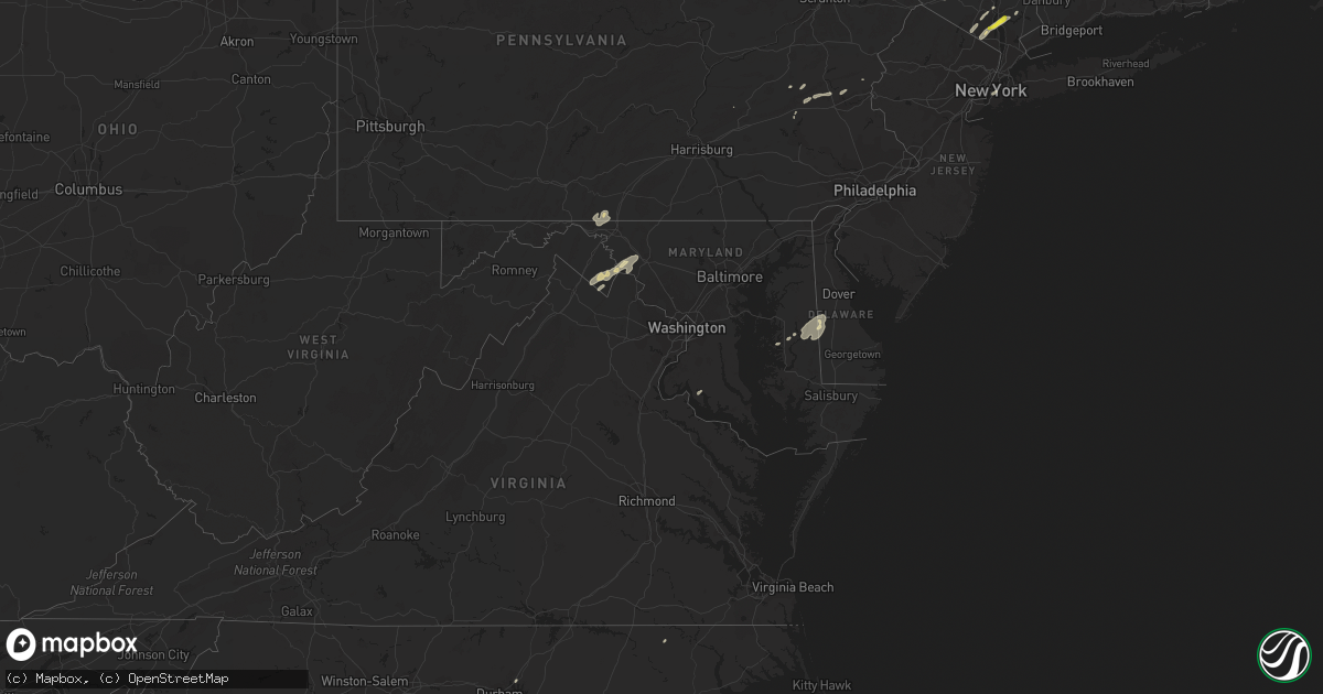
Hail Map in Maryland on June 19, 2017
Get this storm
June 19 map
$229
one time, instant access
Download today. No call, no setup
Keep the $229
Bought the map and want the full workflow? Apply the entire $229 to a subscription within 7 days. None of it is wasted.
Every map, not just this one
This buys you this map. Subscription and you get every map we run, in the markets you choose from a few cities to whole states to nationwide. Plus real-time alerts the moment a storm fires.
Contact data
Name, contact info, occupancy, even credit band for addresses in the footprint. You go from where it hit to who to call.
Become the source they trust
Unlimited branding weather history reports on demand. You already have the documented answer ready for the property owner, and you are the one who showed up with it.
Property data and RoofTrace estimates
Pull up any address you have got, its value and the exact code rules for that jurisdiction, straight from One Click Code. Then RoofTrace estimates the squares, pitch, and roof value, priced the way you price.
Storm reports in Maryland
Maryland
| Date | Description |
|---|---|
| 06/19/20175:00 PM CDT | Numerous trees downed along williamsburg rd and east new market hurlock rd areas in hurlock. One home sustained minor damage. |
| 06/19/20175:00 PM CDT | Several trees and wires blown down. Time estimated from radar. |
| 06/19/20174:54 PM CDT | Several trees down. |
| 06/19/20174:39 PM CDT | Multiple trees down. |
| 06/19/20174:34 PM CDT | Tree down in 48000 block of long lane |
| 06/19/20174:32 PM CDT | Multiple trees down. |
| 06/19/20174:31 PM CDT | Pine tree snapped in half at three notch road and wickshire court |
| 06/19/20174:30 PM CDT | Tree down in 20800 block of hermanville rd |
| 06/19/20174:25 PM CDT | Several trees and wires blown down. Time estimated from radar. |
| 06/19/20174:20 PM CDT | Several trees and wires blown down. Time estimated from radar. |
| 06/19/20174:15 PM CDT | Two trees down at wilson road and plum point road |
| 06/19/20174:08 PM CDT | Tree down at 2219 cape leonard dr |
| 06/19/20174:05 PM CDT | Tree down on 27000 block of north sandgates road |
| 06/19/20174:05 PM CDT | Tree down at 1735 german chapel rd |
| 06/19/20174:02 PM CDT | Tree down at sixes rd and adelina rd |
| 06/19/20173:55 PM CDT | Tree down on 23500 block of maypole rd |
| 06/19/20173:49 PM CDT | Tree down on 27400 block of budds creek rd |
| 06/19/20173:40 PM CDT | A few trees blown down. Time estimated from radar. |
| 06/19/20173:22 PM CDT | A local report indicates 58 MPH wind near 1 SW FORT SMALLWOOD STA |
| 06/19/20173:21 PM CDT | Tree on house at 216 gross ave |
| 06/19/20173:18 PM CDT | Tree down with wires on road at 860 south shore drive |
| 06/19/20173:11 PM CDT | Tree down on intersection of leeds road and walnut grove road |
| 06/19/20173:02 PM CDT | Tree down at sixes rd and adelina rd |
| 06/19/20172:58 PM CDT | A few trees down on goddard space flight center campus |
| 06/19/20172:58 PM CDT | Two large trees down...one onto a house...near the intersection of silvergate lane and silverbrook way in bowie. |
| 06/19/20172:56 PM CDT | Large tree limb in road near md 202 and kettering dr |
| 06/19/20172:54 PM CDT | 12 to 14 inch in diameter tree fell onto fence on ridge road. |
| 06/19/20172:51 PM CDT | Part of a tree snapped off onto portion of road near intersection of adelphi rd and university boulevard. Measured about 12 inches in diameter. |
| 06/19/20172:49 PM CDT | Numerous large trees down around lake artemesia. |
| 06/19/20172:48 PM CDT | Many large tree branches were snapped. A few trees were uprooted and snapped into homes. Rated ef-0 with estimated winds of 70 mph...path length 0.2 miles...and path wi |
| 06/19/20172:45 PM CDT | At least six houses damaged near intersection of georgia avenue and dennis avenue |
| 06/19/20172:37 PM CDT | Tree down and blocking all lanes on seven locks rd near intersection of glennon dr |
| 06/19/20171:23 PM CDT | Tree across roadway in 5200 block of green valley road. |
| 06/19/20171:09 PM CDT | Tree in roadway in 4800 block of east basford road. |
| 06/19/201712:50 PM CDT | Tree in roadway near the intersection of sundays lane and pocono court. |
| 06/18/20177:20 PM CDT | Power line downed onto road along us-50 between cambridge and linkwood. |
| 06/18/20177:10 PM CDT | Numerous trees downed along williamsburg rd and east new market hurlock rd areas in hurlock. |
All States Impacted by Hail Map on June 19, 2017
Cities Impacted by Hail Map on June 19, 2017
- Kempton, PA
- New Tripoli, PA
- Burlington, WI
- Galva, IL
- Goochland, VA
- Powhatan, VA
- Plymouth, IN
- Argos, IN
- Imperial, TX
- Fort Stockton, TX
- Middletown, NY
- Castleton On Hudson, NY
- Nassau, NY
- Schodack Landing, NY
- Akron, MI
- Fairgrove, MI
- Chaparral, NM
- Bunnlevel, NC
- Lillington, NC
- Spring Lake, NC
- Whitney, TX
- East Troy, WI
- Elkhorn, WI
- El Paso, TX
- Canutillo, TX
- Clifton, TX
- Aquilla, TX
- Greencastle, PA
- Mercersburg, PA
- Clear Spring, MD
- Monson, ME
- Cordova, MD
- Ruby, SC
- Mount Croghan, SC
- Jefferson, SC
- Pageland, SC
- Rohrersville, MD
- Knoxville, MD
- Brownsville, MD
- Fort Hancock, TX
- Jackson Springs, NC
- Anthony, TX
- Sunland Park, NM
- Santa Teresa, NM
- East Millinocket, ME
- Putnam Valley, NY
- Hopewell Junction, NY
- Mahopac, NY
- Stormville, NY
- Carmel, NY
- Haverstraw, NY
- West Haverstraw, NY
- Croton On Hudson, NY
- Warrenton, VA
- Denton, MD
- Harrington, DE
- New Liberty, IA
- Stockton, IA
- Charlotte Hall, MD
- Newburg, MD
- Sand Lake, NY
- West Sand Lake, NY
- East Greenbush, NY
- Averill Park, NY
- Shoemakersville, PA
- Burkittsville, MD
- Jefferson, MD
- Davenport, IA
- Rock Island, IL
- Moline, IL
- Slatington, PA
- Schnecksville, PA
- Germansville, PA
- Ridgeway, WI
- Cambridge, IL
- Fort Bragg, NC
- Raeford, NC
- Easton, MD
- East Nassau, NY
- Las Cruces, NM
- Slate Hill, NY
- New Hampton, NY
- Cortlandt Manor, NY
- New City, NY
- Gansevoort, NY
- Schuylerville, NY
- Saratoga Springs, NY
- Anthony, NM
- Big Island, VA
- Ranger, TX
- Sugar Land, TX
- Richmond, TX
- North Judson, IN
- Abbott, TX
- Hillsboro, TX
- Mescalero, NM
- Hamilton, TX
- Marathon, TX
- Felton, DE
- Greensboro, MD
- Walkerton, IN
- Suffern, NY
- Spring Valley, NY
- Montrose, NY
- Monsey, NY
- Garnerville, NY
- Yorktown Heights, NY
- Pomona, NY
- Desdemona, TX
- Poughquag, NY
- Lagrangeville, NY
- Verbank, NY
- Weed, CA
- Gazelle, CA
- Mcarthur, CA
- Brewster, NY
- Patterson, NY
- Canterbury, NH
- Conway, NC
- Whitehall, PA
- Northampton, PA
- Coplay, PA
- Hanover, NM
- Harpers Ferry, WV
- Brooklyn, NY
- Candor, NC
- Ellerbe, NC
- Meridian, TX
- Morgan, TX
- Orion, IL
- Pawling, NY
- Bingham, ME
- Macdoel, CA
- Gorman, TX
- Caro, MI
- Jonesville, MI
- Covington, TX
- Blum, TX
- Creedmoor, NC
- Deming, NM
- Pewaukee, WI
- Castleton, VA
- Rixeyville, VA
- Ridgeville, SC
- Whitewater, WI
- Palmyra, WI
- Amawalk, NY
- Katonah, NY
- Granite Springs, NY
- Wanatah, IN
- Mimbres, NM
- Southfields, NY
- Fort Montgomery, NY
- Litchfield, CT
- Brooklyn, WI
- Gilford, NH
- Mirror Lake, NH
- Laconia, NH
- Lynn Center, IL
- Charles Town, WV
- Ranson, WV
- Hamburg, PA
- Brunswick, MD
- Millville, WV
- Berryville, VA
- Shenandoah Junction, WV
- Middletown, MD
- Summit Point, WV
- Keedysville, MD
- Sharpsburg, MD
- Kearneysville, WV
- Hamlet, IN
- Union Mills, IN
- Silver City, NM
- Gabbs, NV
- Osco, IL
- Jonesboro, TX
- Reese, MI
- Marshall, VA
- Amissville, VA
- Apex, NC
- Durham, NC
- Dousman, WI
- Stillwater, NY
- Brownville, ME
- Aberdeen, NC
- Union, NH
- Rochester, IN
- Pen Argyl, PA
- Nazareth, PA
- Millbrook, NY
- Pleasant Valley, NY
- Dagsboro, DE
- Abbot, ME
- Torrington, CT
- Norfolk, CT
- Goshen, CT
- Winsted, CT
- Sloatsburg, NY
- Tuxedo Park, NY
- Kansasville, WI
- Salem, WI
- Union Grove, WI
- Kenosha, WI
- Angier, NC
- Coats, NC
- Missouri City, TX
- Millsboro, DE
- Tamaqua, PA
- Tower City, PA
- Milford, IN
- Leesburg, IN
- Guilford, ME
- New Portland, ME
- Gardiner, NY
- Wallkill, NY
- Maybrook, NY
- Montgomery, NY
- Campbell Hall, NY
- Grimesland, NC
- Greenville, NC
- Ridgely, MD
- Federalsburg, MD
- Preston, MD
- Greenwood, DE
- Bayard, NM
- Coal Valley, IL
- Watertown, CT
- Dover Foxcroft, ME
- Petersburg, NY
- Goode, VA
- Bedford, VA
- Coleman Falls, VA
- Monroe, VA
- Lynchburg, VA
- New Ringgold, PA
- Gatesville, TX
- Grovertown, IN
- Concord, NH
- Highland Falls, NY
- Linden, NC
- La Fayette, IL
- Java, VA
- Vanceboro, NC
- Cartersville, VA
- Alturas, CA
- Ely, NV
- Spring Creek, NV
- Adamsville, PA
- Jamestown, PA
- Hartstown, PA
- Waukesha, WI
- Wauconda, IL
- Island Lake, IL
- Crystal Lake, IL
- Barrington, IL
- Mchenry, IL
- Brillion, WI
- Reedsville, WI
- Alpine, TX
- White Sands Missile Range, NM


