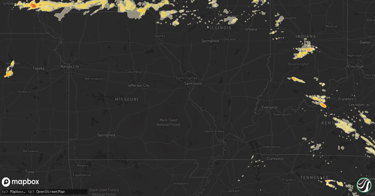
Hail Map in Nebraska on June 19, 2011
Get this storm
June 19 map
$229
one time, instant access
Download today. No call, no setup
Keep the $229
Bought the map and want the full workflow? Apply the entire $229 to a subscription within 7 days. None of it is wasted.
Every map, not just this one
This buys you this map. Subscription and you get every map we run, in the markets you choose from a few cities to whole states to nationwide. Plus real-time alerts the moment a storm fires.
Contact data
Name, contact info, occupancy, even credit band for addresses in the footprint. You go from where it hit to who to call.
Become the source they trust
Unlimited branding weather history reports on demand. You already have the documented answer ready for the property owner, and you are the one who showed up with it.
Property data and RoofTrace estimates
Pull up any address you have got, its value and the exact code rules for that jurisdiction, straight from One Click Code. Then RoofTrace estimates the squares, pitch, and roof value, priced the way you price.
Storm reports in Nebraska
Nebraska
| Date | Description |
|---|---|
| 06/19/20116:48 PM CDT | Chase county sheriff reported tornado 8 miles south of waneta |
| 06/19/20116:47 PM CDT | Tornado was in an open field and lasted 4 minutes. |
| 06/19/20116:44 PM CDT | Tornado lasted for 3 minutes. Multiple sightings of this same tornado. |
| 06/19/20116:38 PM CDT | A local report indicates 1.75 inch wind near 6 N STUART |
| 06/19/20116:36 PM CDT | A local report indicates 1.75 inch wind near 5 NNE STUART |
| 06/19/20116:22 PM CDT | Marble to ping pong ball sized hail partially covering the ground |
| 06/19/20116:02 PM CDT | A local report indicates 2.75 inch wind near 10 WNW IMPERIAL |
| 06/19/20116:02 PM CDT | The hail lasted for 20 minutes. |
| 06/19/20115:53 PM CDT | Quarters and half dollars size hail reported in newport. |
| 06/19/20115:25 PM CDT | Public reported quarter sized hail 5 miles ssw of newport |
| 06/19/20113:50 PM CDT | Strong winds over 60 mph caused extensive large tree damage. Structural damage to a home by a fallen tree and pivot irrigation system overturned. |
| 06/19/20112:55 PM CDT | A local report indicates 1.50 inch wind near 8 S KIMBALL |
| 06/19/20119:23 AM CDT | Imperial asos reported a wind gust of 77 mph. Delayed report. |
| 06/19/20113:30 AM CDT | A local report indicates 60 MPH wind near CENTRAL CITY |
| 06/19/20113:27 AM CDT | A local report indicates 60 MPH wind near 2 E CHAPMAN |
| 06/19/20112:35 AM CDT | Still a few stones falling at 241 am. |
| 06/19/20112:30 AM CDT | Estimated wind gusts up to 60 mph. |
| 06/19/20112:20 AM CDT | Delayed report of hail which caused broken siding on their home. Time estimated from radar. |
| 06/19/20112:11 AM CDT | A local report indicates 1.00 inch wind near 3 W KEARNEY |
| 06/19/20112:05 AM CDT | Delayed report from public relayed by omaha national weather service office. |
| 06/19/20112:02 AM CDT | Corrected location from original report |
| 06/19/20112:02 AM CDT | A local report indicates 1.75 inch wind near 2 W SILVER CREEK |
| 06/19/20112:00 AM CDT | 2 large trees blown down in city park. |
| 06/19/20111:44 AM CDT | Corrected location from original report to put in merrick county. Old elevator blown across highway 30. Debris covering the road between clarks and silver creek. Power |
| 06/19/20111:44 AM CDT | Old elevator blown across highway 30. Debris covering the road between clarks and silver creek. Power lines down in clarks and power is out to the town of clarks. |
| 06/19/20111:36 AM CDT | Chase county sheriff reported golf ball sized hail and very heavy rain in wauneta |
| 06/19/20111:30 AM CDT | Delayed report via nerain observer. Golf ball size started around 130am and lasted 15-20 minutes. |
| 06/19/20111:17 AM CDT | A local report indicates 1.50 inch wind near 12 S ELWOOD |
| 06/19/20111:16 AM CDT | A local report indicates 1.25 inch wind near 6 N ARAPAHOE |
| 06/19/20111:15 AM CDT | A local report indicates 1.25 inch wind near 10 S ELWOOD |
| 06/19/20111:13 AM CDT | 60 to 65 mph winds...heavy rain and nickel size hail. Several 6 inch diameter tree limbs down on highway 183. |
| 06/19/20111:10 AM CDT | Two inch diameter tree limbs down. |
| 06/19/20111:08 AM CDT | Large tree blown down on power lines. Six center pivots flipped over. |
| 06/19/201112:46 AM CDT | Winds estimated at 60 to 70 mph. |
| 06/19/201112:35 AM CDT | 2-3 inch diameter tree limbs down. Pea to penny size hail. |
| 06/19/201112:14 AM CDT | Reports of sky lights being broke out also. |
| 06/19/201112:01 AM CDT | A local report indicates 1.00 inch wind near 13 SE HAYES CENTER |
| 06/18/201111:55 PM CDT | The hail damaged siding. |
| 06/18/201111:55 PM CDT | Time of report was estimated. |
| 06/18/201111:53 PM CDT | A local report indicates 2.50 inch wind near COTESFIELD |
| 06/18/201111:40 PM CDT | A local report indicates 1.50 inch wind near 7 SE ARNOLD |
| 06/18/201111:40 PM CDT | Delayed report of hail and 60 mph winds from nebraska rainfall assessment and information network observer. Time estimated from radar. |
| 06/18/201111:32 PM CDT | A local report indicates 1.75 inch wind near UNION |
| 06/18/201111:15 PM CDT | A local report indicates 1.75 inch wind near 5 NE CURTIS |
| 06/18/201110:45 PM CDT | Delayed report. Large hail to ping pong ball size cracked truck windshield and punched holes in vinyl siding on home. |
| 06/18/201110:37 PM CDT | Corrected for location. |
| 06/18/201110:37 PM CDT | A local report indicates 1.50 inch wind near 2 SW ATLANTA |
| 06/18/201110:36 PM CDT | A local report indicates 1.75 inch wind near CAMBRIDGE |
| 06/18/201110:35 PM CDT | A local report indicates 1.75 inch wind near IMPERIAL |
| 06/18/201110:30 PM CDT | A local report indicates 2.00 inch wind near NEBRASKA CITY |
| 06/18/201110:30 PM CDT | A local report indicates 1.00 inch wind near 12 NE HAYES CENTER |
| 06/18/201110:30 PM CDT | Hail ranged from quarter to golf ball size - with some hail as large as tennis balls. Roof damage at residence. |
| 06/18/201110:30 PM CDT | Delayed report. Time estimated from radar. |
| 06/18/201110:25 PM CDT | Chase county sheriff reported golf ball and baseball sized hail in champion |
| 06/18/201110:15 PM CDT | Delayed report from yesterday evening. |
| 06/18/201110:13 PM CDT | A local report indicates 1.50 inch wind near 1 N EDISON |
| 06/18/201110:12 PM CDT | A local report indicates 2.50 inch wind near 4 W ARAPAHOE |
| 06/18/201110:12 PM CDT | A local report indicates 2.50 inch wind near 4 E ARAPAHOE |
| 06/18/201110:08 PM CDT | Hail with 60 mph wind gusts. |
| 06/18/201110:08 PM CDT | A local report indicates 1.75 inch wind near ARAPAHOE |
| 06/18/201110:05 PM CDT | Delayed report. Siding and roof damage caused by golf ball sized hail. |
| 06/18/201110:05 PM CDT | A local report indicates 65 MPH wind near 2 N EDISON |
| 06/18/201110:03 PM CDT | Golf ball sized hailed reported near gosper county line |
| 06/18/201110:00 PM CDT | Delayed report of hail the size of quarters with a few half dollar sized stones. |
| 06/18/201110:00 PM CDT | Quarter to half dollar sized hail caused siding damage on west side of home along with one broken window. |
| 06/18/201110:00 PM CDT | Estimated around 10 pm cdt with extensive crop damage from three separate storm cells. |
| 06/18/201110:00 PM CDT | Delayed report of pea to quarter size hail. Storm total rainfall was 1.70 inches at this location. |
| 06/18/201110:00 PM CDT | A local report indicates 1.75 inch wind near 9 NE BROKEN BOW |
| 06/18/201110:00 PM CDT | Hail fell around 10-1015 pm. |
| 06/18/20119:59 PM CDT | A local report indicates 2.50 inch wind near ARAPAHOE |
| 06/18/20119:57 PM CDT | A local report indicates 1.50 inch wind near 11 S NORTH PLATTE |
| 06/18/20119:49 PM CDT | A local report indicates 1.25 inch wind near 10 S NORTH PLATTE |
| 06/18/20119:40 PM CDT | Garage and barn destroyed. Trees 1.5 to 2 feet in diameter are down. Power lines are also down. |
| 06/18/20119:38 PM CDT | A local report indicates 1.00 inch wind near NEBRASKA CITY |
| 06/18/20119:38 PM CDT | 45 to 50 mph winds with gusts of 65 mph. Also rotation in storm. |
| 06/18/20119:30 PM CDT | Estimated largest hail to be slightly larger than a golfball. Reported extensive damage with all windows destroyed as well as significant crop damage. |
| 06/18/20119:30 PM CDT | Main transmission lines blown down just north of cambridge. Air conditioning units blown off of hospital in cambridge. |
| 06/18/20119:23 PM CDT | Imperial asos reported a wind gust of 77 mph. Delayed report. |
| 06/18/20119:05 PM CDT | Time is estimated...this is a delayed report. |
| 06/18/20119:00 PM CDT | A local report indicates 1.00 inch wind near 7 SW HAYES CENTER |
| 06/18/20118:59 PM CDT | A local report indicates 1.25 inch wind near 6 NE ARNOLD |
| 06/18/20118:57 PM CDT | Multiple tornadoes reported |
| 06/18/20118:40 PM CDT | A local report indicates 1.75 inch wind near STOCKVILLE |
| 06/18/20118:20 PM CDT | Multiple tornadoes reported |
| 06/18/20118:15 PM CDT | A local report indicates 1.00 inch wind near W BRULE |
| 06/18/20117:45 PM CDT | Golf ball sized hail 9 se of hayes center |
| 06/18/20117:40 PM CDT | A local report indicates a tornado near 6 S PALISADE |
| 06/18/20117:39 PM CDT | A local report indicates 1.00 inch wind near 4 S BIG SPRINGS |
| 06/18/20117:30 PM CDT | Time of report corrected. |
| 06/18/20117:12 PM CDT | Public reported golf ball sized hail 10 sw of hayes center |
| 06/18/20117:12 PM CDT | Public reported golf ball sized hail 10 s of hayes center |
| 06/18/20117:06 PM CDT | Public reported a few hail stones the size of a quarter...but most were the size of a large marble. |
| 06/18/20117:04 PM CDT | A local report indicates a tornado near 13 NNE BENKELMAN |
All States Impacted by Hail Map on June 19, 2011
Cities Impacted by Hail Map on June 19, 2011
- Palisade, NE
- Hayes Center, NE
- Elwood, NE
- Maywood, NE
- Edison, NE
- Holdrege, NE
- McCook, NE
- Elsie, NE
- Stockville, NE
- Haigler, NE
- Bartley, NE
- Farnam, NE
- Eustis, NE
- Moorefield, NE
- Arapahoe, NE
- Culbertson, NE
- Bertrand, NE
- Wray, CO
- Holbrook, NE
- Indianola, NE
- Wauneta, NE
- Cambridge, NE
- Holyoke, CO
- Champion, NE
- Atlanta, NE
- Parks, NE
- Enders, NE
- Curtis, NE
- Oxford, NE
- Maxwell, NE
- Benkelman, NE
- Imperial, NE
- Seneca, IL
- Morris, IL
- Newark, IL
- Marseilles, IL
- Robbins, TN
- Paxton, IL
- Fremont, IA
- Cedar, IA
- Mount Olive, NC
- Liberty, MO
- Callaway, NE
- Waukee, IA
- Van Meter, IA
- West Des Moines, IA
- Cumming, IA
- Dover, TN
- Buda, IL
- Bradford, IL
- Sheffield, IL
- Neponset, IL
- Stilesville, IN
- Monrovia, IN
- Ashland, NE
- Lacona, IA
- Chariton, IA
- Blair, NE
- Kennard, NE
- Iroquois, IL
- Watseka, IL
- Sheldon, IL
- Sparta, TN
- Doyle, TN
- Kim, CO
- Memphis, MO
- Arbela, MO
- Menlo, IA
- Cedar Island, NC
- Prague, NE
- Cedar Bluffs, NE
- Colon, NE
- Malmo, NE
- Morse Bluff, NE
- Fremont, NC
- Stantonsburg, NC
- Waynesburg, KY
- Gravel Switch, KY
- Kings Mountain, KY
- Springfield, KY
- Middleburg, KY
- Yosemite, KY
- Hustonville, KY
- Eubank, KY
- Bethelridge, KY
- Stanford, KY
- Parksville, KY
- Liberty, KY
- Crab Orchard, KY
- Lebanon, KY
- Elk Horn, KY
- Bradfordsville, KY
- Bean Station, TN
- Yutan, NE
- Valley, NE
- Blakesburg, IA
- Unionville, IA
- Drakesville, IA
- Strasburg, CO
- Bennett, CO
- Wallace, KS
- Sharon Springs, KS
- Science Hill, KY
- Indianapolis, IN
- Elk Horn, IA
- Marne, IA
- Avoca, IA
- Harlan, IA
- Kimballton, IA
- Walnut, IA
- Branson, CO
- Dickens, NE
- Wellfleet, NE
- Albia, IA
- Moravia, IA
- Axtell, NE
- Fairland, IN
- Louisville, KY
- Elizabeth, IN
- Lanesville, IN
- New Albany, IN
- Las Animas, CO
- La Junta, CO
- Murdock, NE
- Rosalie, NE
- Lyons, NE
- Herman, NE
- Arlington, NE
- Covington, IN
- Kingman, IN
- Ordway, CO
- Olney Springs, CO
- Unionville, MO
- Coatsville, MO
- Pulaski, IA
- Livonia, MO
- Udell, IA
- Bloomfield, IA
- Exline, IA
- Moulton, IA
- Centerville, IA
- Keosauqua, IA
- Silver Creek, NE
- Chavies, KY
- Lost Creek, KY
- Eagleville, MO
- Hatfield, MO
- Sparland, IL
- Marquette, NE
- Central City, NE
- Nodaway, IA
- Corning, IA
- Colchester, IL
- Plymouth, IL
- Clarks, NE
- Fullerton, NE
- Woodrow, CO
- Keota, IA
- Spencer, TN
- San Jose, IL
- Emden, IL
- Crook, CO
- Knoxville, IA
- La Moille, IL
- Arlington, IL
- Easley, SC
- Erin, TN
- Vail, IA
- Tazewell, TN
- Sneedville, TN
- Scotia, NE
- Loup City, NE
- Saint Paul, NE
- Elba, NE
- North Loup, NE
- Wolbach, NE
- Ashton, NE
- Edina, MO
- Wyaconda, MO
- Rutledge, MO
- La Belle, MO
- Knox City, MO
- Ithaca, NE
- Florence, SC
- Conway, SC
- Myrtle Beach, SC
- Broken Bow, NE
- Mount Ayr, IA
- Benton, IA
- Diagonal, IA
- Milan, IL
- Sherrard, IL
- Effingham, SC
- Mead, NE
- Wahoo, NE
- Saint Patrick, MO
- Kahoka, MO
- Cheyenne, WY
- Dodge, NE
- Hordville, NE
- Rose Hill, IA
- Delta, IA
- La Harpe, IL
- Dix, NE
- Palmer, NE
- Milan, MO
- Logan, IA
- Persia, IA
- Allerton, IA
- Humeston, IA
- Corydon, IA
- Columbus, NE
- Dallas City, IL
- Snow Hill, NC
- Wapello, IA
- Morning Sun, IA
- Yuma, CO
- Richmond, KY
- Ellston, IA
- Tingley, IA
- Shannon City, IA
- Guernsey, IA
- Sidney, IA
- Cheraw, CO
- Rocky Ford, CO
- London, KY
- Orleans, IN
- Mitchell, IN
- Toulon, IL
- Hamlin, IA
- Exira, IA
- Audubon, IA
- Bourbonnais, IL
- Barnes City, IA
- Montezuma, IA
- New Sharon, IA
- Roggen, CO
- Merna, NE
- Brady, NE
- Gothenburg, NE
- Anselmo, NE
- Arnold, NE
- Grand Ridge, IL
- Ottawa, IL
- Streator, IL
- Des Moines, IA
- Carlisle, IA
- Glasgow, KY
- Lucas, KY
- Scottsville, KY
- Plattsmouth, NE
- Casey, IA
- Dexter, IA
- Stuart, IA
- Rogersville, TN
- Faison, NC
- Mossville, IL
- Chillicothe, IL
- Watkins, CO
- Winona, KS
- Wellman, IA
- Gresham, SC
- Webster, IA
- Sigourney, IA
- Nichols, SC
- Ashkum, IL
- Clifton, IL
- Pikeville, TN
- Cameron, MO
- Fairdale, KY
- Shepherdsville, KY
- Brooks, KY
- Mount Washington, KY
- Gretna, NE
- Bellwood, NE
- Shelby, NE
- Belgrade, NE
- Genoa, NE
- Veedersburg, IN
- Winterset, IA
- Edward, NC
- Blounts Creek, NC
- Aurora, NC
- Pineville, KY
- Williamsburg, KY
- Harrogate, TN
- Calvin, KY
- Barbourville, KY
- Middlesboro, KY
- Rockholds, KY
- Cumberland Gap, TN
- Bryants Store, KY
- Corbin, KY
- Kankakee, IL
- Gravity, IA
- New Market, IA
- Bedford, IA
- Clearfield, IA
- Clarinda, IA
- Sharpsburg, IA
- Mohawk, TN
- Midway, TN
- North Bend, NE
- Towanda, IL
- Junction City, KS
- Dwight, KS
- White City, KS
- Missouri Valley, IA
- Monterey, TN
- Eckley, CO
- Venango, NE
- Henry, IL
- Putnam, IL
- Tiskilwa, IL
- Williams, IN
- Shoals, IN
- Bargersville, IN
- Martinsville, IN
- Morgantown, IN
- Keystone, NE
- Paxton, NE
- Crowley, CO
- Denison, IA
- Manilla, IA
- Swink, CO
- Wiley, CO
- Eads, CO
- McClave, CO
- Tribune, KS
- Hasty, CO
- Sheridan Lake, CO
- Weskan, KS
- Arlington, CO
- Afton, IA
- Johnston, IA
- Farragut, IA
- Riverton, IA
- Shenandoah, IA
- Basco, IL
- Corydon, IN
- New Salisbury, IN
- Ramsey, IN
- Fort Morgan, CO
- Otis, CO
- McKee, KY
- Berea, KY
- Irvine, KY
- Panora, IA
- Plano, IA
- Seymour, IA
- Promise City, IA
- Lafayette, TN
- Wallace, NE
- Pamplico, SC
- Timmonsville, SC
- Oakland, KY
- Smiths Grove, KY
- Bowling Green, KY
- Edelstein, IL
- Dunlap, IL
- Princeville, IL
- Speer, IL
- Wyoming, IL
- Campbellsburg, IN
- Loogootee, IN
- Crane, IN
- Funk, NE
- Bonaparte, IA
- Mount Sterling, IA
- Hillsboro, IA
- Augusta, IL
- Franklin, NC
- Georgetown, KY
- Saint Charles, IA
- North Platte, NE
- Clearmont, MO
- Burlington Junction, MO
- Lillington, NC
- Angier, NC
- Spring City, TN
- Rockwood, TN
- Skidmore, MO
- Clinton, NC
- Turkey, NC
- Magnolia, NC
- Warsaw, NC
- Chula, MO
- Galva, IL
- Kewanee, IL
- Elmwood, NE
- Palmyra, NE
- Eagle, NE
- Piper City, IL
- Reddick, IL
- Danforth, IL
- Buckingham, IL
- Chebanse, IL
- Herscher, IL
- Cabery, IL
- Gilman, IL
- Atkinson, NE
- West Point, NE
- David City, NE
- Fairfax, MO
- Earlham, IA
- Haxtun, CO
- Amherst, CO
- Depauw, IN
- Milltown, IN
- Queen City, MO
- Downing, MO
- Shelton, NE
- Kenesaw, NE
- Thorn Hill, TN
- Mooresburg, TN
- Blandinsville, IL
- Hershey, NE
- Metamora, IL
- East Peoria, IL
- Peoria, IL
- Avoca, NE
- Union, NE
- Randolph, IA
- Imogene, IA
- Thurman, IA
- Nehawka, NE
- Percival, IA
- Otoe, NE
- Hamburg, IA
- Nebraska City, NE
- Greenville, SC
- Carthage, IL
- Greeley, NE
- Quebeck, TN
- Perrysville, IN
- Wood River, NE
- Pleasant Hill, IA
- Ansley, NE
- Westerville, NE
- Bradley, IL
- Westmoreland, TN
- Good Hope, IL
- Bushnell, IL
- Greeneville, TN
- McLean, IL
- Stanford, IL
- Armington, IL
- Ceresco, NE
- Milton, IA
- Douds, IA
- Manhattan, KS
- Omaha, NE
- Truro, IA
- New Virginia, IA
- Gilson, IL
- Dahinda, IL
- Essex, IL
- Bonfield, IL
- Wilmington, IL
- Memphis, NE
- Atlantic, IA
- Mason City, IL
- Forest City, IL
- Easton, IL
- Keenesburg, CO
- Mosheim, TN
- Bulls Gap, TN
- Cozad, NE
- Warne, NC
- Brasstown, NC
- Hayesville, NC
- Murphy, NC
- Cookeville, TN
- Rogers, NE
- Linwood, NE
- Louisville, NE
- Weeping Water, NE
- Kimball, NE
- New Raymer, CO
- Model, CO
- Rock Island, TN
- Marion, SC
- Hollywood, FL
- Eddyville, IA
- Sidney, NE
- Marshall, IN
- Bloomingdale, IN
- Wilson, NC
- Burlington, IA
- West Burlington, IA
- Saint Marys, IA
- Prole, IA
- Griswold, IA
- Princeton, IL
- Bureau, IL
- Wyanet, IL
- Brush, CO
- Akron, CO
- Linden, TN
- Lancaster, KY
- Miracle, KY
- Creston, IA
- Lenox, IA
- Pender, NE
- Junction City, KY
- Franklin, IN
- Greenwood, IN
- Windsor Heights, IA
- Searsboro, IA
- Grinnell, IA
- Springfield, NE
- King City, MO
- Oakville, IA
- Riverside, IA
- Kalona, IA
- Somerset, KY
- Bardstown, KY
- Joy, IL
- New Boston, IL
- Carlock, IL
- Sublette, IL
- Ohio, IL
- Van Orin, IL
- Ewing, VA
- Westside, IA
- Wall Lake, IA
- Breda, IA
- Odebolt, IA
- Hooper, NE
- Comstock, NE
- Walton, NE
- Harrells, NC
- Elizabethtown, NC
- Garland, NC
- Grand Island, NE
- Snyder, CO
- Parnell, IA
- What Cheer, IA
- Brooklyn, IA
- Malcom, IA
- Fremont, NE
- Scribner, NE
- Winslow, NE
- Ames, NE
- Fontanelle, IA
- Leland, IL
- Osceola, NE
- Monroe, NE
- Oakland, NE
- Derby, IA
- Lamoni, IA
- Garden Grove, IA
- Leon, IA
- Russell, IA
- Millerton, IA
- Weldon, IA
- Kellerton, IA
- Grand River, IA
- Decatur, IA
- Van Wert, IA
- Minooka, IL
- Schuyler, NE
- Newport, NC
- Siler, KY
- Frakes, KY
- Speedwell, TN
- New Tazewell, TN
- Morristown, TN
- Whitesburg, TN
- Russellville, TN
- Adair, IA
- Guthrie Center, IA
- Anita, IA
- Wilcox, NE
- Lindsay, NE
- Salem, IA
- Walthill, NE
- Stuart, NE
- Atlanta, IL
- Orleans, NE
- Kearney, NE
- Loomis, NE
- Elm Creek, NE
- Verona, IL
- Murray, IA
- Morehead City, NC
- Orrick, MO
- Masonic Home, KY
- Nauvoo, IL
- Niota, IL
- Hamilton, IL
- Mooresville, IN
- Whiteland, IN
- Sutter, IL
- Washington, IL
- Shelbyville, IN
- Hubert, NC
- Stella, NC
- Maysville, NC
- Crescent City, IL
- Albany, MO
- Young Harris, GA
- Hiawassee, GA
- Iowa City, IA
- Lone Tree, IA
- Hills, IA
- Coralville, IA
- Deep River, IA
- Coxs Creek, KY
- Downs, IL
- Le Roy, IL
- Craig, NE
- Onarga, IL
- Hemingway, SC
- Marshall, NC
- Mars Hill, NC
- Nickerson, NE
- Rising City, NE
- Marysville, IN
- Underwood, IN
- Nabb, IN
- Lexington, IN
- Garner, NC
- Polk City, IA
- Madrid, IA
- Rock Port, MO
- Iliff, CO
- Lemoyne, NE
- Lineville, IA
- Hopkins, MO
- Smithfield, IL
- Ellisville, IL
- Cuba, IL
- Minden, NE
- La Vista, NE
- Boys Town, NE
- Howells, NE
- Stanton, NE
- Clarkson, NE
- Manzanola, CO
- Fowler, CO
- Davis City, IA
- Blythedale, MO
- Pine Village, IN
- West Lafayette, IN
- Westpoint, IN
- Otterbein, IN
- Williamsport, IN
- Attica, IN
- Galesburg, IL
- Woodhull, IL
- New Windsor, IL
- Rio, IL
- Oneida, IL
- Alpha, IL
- North Henderson, IL
- Martinton, IL
- Defiance, IA
- Murray, NE
- Warsaw, IL
- Alexandria, MO
- Jackson, KY
- Rowdy, KY
- Hazard, KY
- Whick, KY
- Wiota, IA
- Boston, KY
- New Haven, KY
- Cainsville, MO
- Hale, MO
- Gray Court, SC
- Enoree, SC
- Redfield, IA
- Linden, IA
- Eminence, KY
- New Castle, KY
- Underwood, IA
- McClelland, IA
- Council Bluffs, IA
- North Liberty, IA
- Belton, SC
- Pelzer, SC
- Paris, TN
- Emerald Isle, NC
- Atlantic Beach, NC
- Salter Path, NC
- Montezuma, IN
- Trinidad, CO
- Lucas, IA
- Montrose, IA
- Tennessee, IL
- Elvaston, IL
- Keokuk, IA
- Macomb, IL
- Gibson, IA
- Gray, KY
- Keavy, KY
- Lily, KY
- Greenfield, IA
- Boelus, NE
- Dannebrog, NE
- Farwell, NE
- Doniphan, NE
- Winchester, KY
- Aledo, IL
- Campton, KY
- Adolphus, KY
- Sutherland, NE
- Thayer, IA
- Julesburg, CO
- Pella, IA
- Lynnville, IA
- Sully, IA
- Monmouth, IL
- Oquawka, IL
- Granville, IL
- Standard, IL
- McNabb, IL
- Wever, IA
- Danville, IA
- West Point, IA
- Kenansville, NC
- Bethpage, TN
- Chatsworth, IL
- Bellevue, NE
- Smithville, TN
- Stockport, IA
- Donnellson, IA
- Farmington, IA
- Monticello, KY
- Alpha, KY
- Grimes, IA
- Urbandale, IA
- Clive, IA
- Granger, IA
- Kirksville, MO
- Clinton, TN
- Powell, TN
- Oxford, IN
- Boswell, IN
- Templeton, IN
- Jamesport, MO
- Crossville, TN
- Mendota, IL
- Roca, NE
- Elkhart, IA
- Tekamah, NE
- West Branch, IA
- Richmond, MO
- Falmouth, KY
- Henryville, IN
- Otisco, IN
- Chillicothe, MO
- La Fayette, IL
- Savannah, MO
- Rea, MO
- Earling, IA
- Tellico Plains, TN
- Avon, SD
- Humphrey, NE
- Stapleton, NE
- Mullins, SC
- Lancaster, MO
- Rossville, IL
- Coal City, IL
- Dover, NC
- Crothersville, IN
- Brownstown, IN
- Duff, TN
- Beulaville, NC
- Sheridan, MO
- Ridgeway, MO
- Harrodsburg, KY
- Birmingham, IA
- Paragon, IN
- Neola, IA
- Green City, MO
- Bryson City, NC
- Annawan, IL
- Atkinson, IL
- Gibbon, NE
- Selma, NC
- Gallatin, MO
- Fort Riley, KS
- Troy Grove, IL
- Danville, IL
- Cayuga, IN
- Georgetown, IL
- Cissna Park, IL
- Kenly, NC
- Lucama, NC
- Maitland, MO
- Mound City, MO
- Peru, IA
- Orient, IA
- Clayton, NC
- Limestone, TN
- Chuckey, TN
- Grandview, TN
- Massena, IA
- Coin, IA
- Northboro, IA
- Ellsworth, IL
- Archer, NE
- Phillips, NE
- Chapman, NE
- Saint Libory, NE
- North English, IA
- South English, IA
- Ogallala, NE
- Canton, IL
- Albany, KY
- Jamestown, KY
- Syracuse, NE
- Essex, IA
- Yorktown, IA
- Unadilla, NE
- Blanchard, IA
- Tabor, IA
- Dunbar, NE
- Miami, FL
- Middletown, IA
- Norwalk, IA
- Indianola, IA
- Danville, KY
- Lostant, IL
- Tonica, IL
- Sterling, CO
- Brooklyn, IN
- Gosport, IN
- Media, IL
- Stronghurst, IL
- Carman, IL
- Beaverville, IL
- Ravenna, NE
- Litchfield, NE
- Hazard, NE
- Manley, NE
- Green Road, KY
- Hinkle, KY
- Girdler, KY
- Kempton, IL
- Shelby, IA
- Portsmouth, IA
- Perry, IA
- Hillsboro, IN
- Waynetown, IN
- Ovid, CO
- Big Springs, NE
- Chappell, NE
- Osceola, IA
- Woodbine, IA
- Papillion, NE
- Sargent, NE
- Crescent, IA
- Altoona, IA
- Runnells, IA
- Mitchellville, IA
- Hopedale, IL
- Needham, IN
- Beech Grove, IN
- Stinesville, IN
- Clayton, IN
- Ellettsville, IN
- West Newton, IN
- Quincy, IN
- Camby, IN
- Plainfield, IN
- Bloomington, IN
- Polk, NE
- Fort Calhoun, NE
- Honey Creek, IA
- Platte Center, NE
- Duncan, NE
- Weston, NE
- Bruno, NE
- Saint Edward, NE
- Cedar Rapids, NE
- Bennington, NE
- Minden, IA
- Panama, IA
- Kirkman, IA
- Stromsburg, NE
- Modale, IA
- Irwin, IA
- Brookfield, MO
- Sumner, MO
- Stamping Ground, KY
- Fountain Run, KY
- Loris, SC
- Astoria, IL
- Niobrara, NE
- Springfield, SD
- Smithfield, NE
- Arcadia, NE
- Ord, NE
- Delavan, IL
- Galt, MO
- Marietta, IL
- Macy, NE
- Richland, IA
- Weldona, CO
- Malden, IL
- West Brooklyn, IL
- Holly Springs, NC
- Fuquay Varina, NC
- Havana, IL
- Union Star, MO
- Helena, MO
- Potter, NE
- Apex, NC
- Naper, NE
- Ware Shoals, SC
- Laurens, SC
- Amity, MO
- Maysville, MO
- Humphreys, MO
- Ankeny, IA
- Williamsburg, IA
- Sciota, IL
- Avon, IL
- Prairie City, IL
- Roseville, IL
- Etowah, TN
- Bogard, MO
- Heidrick, KY
- Artemus, KY
- Hialeah, FL
- Dow City, IA
- Cove City, NC
- New Bern, NC
- Excello, MO
- Cary, NC
- Manhattan, IL
- Manteno, IL
- Fisher, IL
- Foosland, IL
- Newport, NE
- Livingston, TN
- Pattonsburg, MO
- Hillrose, CO
- Novinger, MO
- Greenwood, NE
- South Bend, NE
- Havelock, NC
- Bridgewater, IA
- Tarkio, MO
- Ravenna, KY
- Linneus, MO
- Purdin, MO
- Red Boiling Springs, TN
- East Galesburg, IL
- Knoxville, IL
- New London, IA
- Clarkrange, TN
- Irvington, KY
- Teachey, NC
- Kellogg, IA
- Russell Springs, KY
- Hudson, IL
- Beattyville, KY
- Piedmont, SC
- Summer Shade, KY
- Stoney Fork, KY
- Arjay, KY
- Woodbine, KY
- Bimble, KY
- Fourmile, KY
- Hulen, KY
- Flat Lick, KY
- Rutledge, TN
- Washburn, TN
- Grand Mound, IA
- Delmar, IA
- Saint Augustine, IL
- Webster, KY
- Kidder, MO
- Viola, IL
- Reynolds, IL
- Slater, IA
- Campbellsville, KY
- Odessa, MO
- West Liberty, IA
- Carson, IA
- Maquon, IL
- Valparaiso, NE
- Wallins Creek, KY
- Coldiron, KY
- Padroni, CO
- Pompano Beach, FL
- Green Valley, IL
- Calypso, NC
- Zebulon, NC
- Middlesex, NC
- Sims, NC
- Scottsburg, IN
- Plattsburg, MO
- Trenton, MO
- Wayland, MO
- Rutland, IL
- Hudson, CO
- Walling, TN
- Austin, IN
- Melrose, IA
- Robbinsville, NC
- Bethany, MO
- New Hampton, MO
- Tompkinsville, KY
- Wiggins, CO
- Keswick, IA
- Topeka, IL
- Mount Pleasant, IA
- Mount Union, IA
- Craig, MO
- Avon, IN
- Fairview, IL
- Tina, MO
- Moorhead, IA
- Abie, NE
- Brayton, IA
- Brainard, NE
- Waverly, NE
- Adel, IA
- Woodward, IA
- Minburn, IA
- Cairo, NE
- Dawson, IA
- Bancroft, NE
- Yale, IA
- Booneville, IA
- Sheldahl, IA
- De Soto, IA
- Waterloo, NE
- Dallas Center, IA
- Leigh, NE
- Harris, MO
- Newtown, MO
- Waco, KY
- Hilham, TN
- Pembroke Township, IL
- Donovan, IL
- Saint Anne, IL
- Morocco, IN
- Eureka, IL
- Peoria Heights, IL
- Lowpoint, IL
- Edwards, IL
- Hillsdale, IN
- Shirley, IL
- Heyworth, IL
- Pickering, MO
- Green Castle, MO
- Park City, KY
- Zolfo Springs, FL
- Lorimor, IA
- Osco, IL
- Blockton, IA
- Booneville, KY
- Crestline, OH
- Tiro, OH
- Stanton, IA
- Villisca, IA
- Nicholasville, KY
- Goshen, KY
- Charlestown, IN
- Prospect, KY
- Hamilton, MO
- Fort Madison, IA
- Denmark, IA
- Saint Paul, IA
- New Concord, KY
- Hazel, KY
- Murray, KY
- Cloverdale, IN
- Coatesville, IN
- Annville, KY
- Smithshire, IL
- Latta, SC
- Sellers, SC
- Coats, NC
- Lavinia, TN
- Redding, IA
- Mystic, IA
- Elmo, MO
- Woodburn, IA
- Lincoln, NE
- Malvern, IA
- Shambaugh, IA
- Alvo, NE
- College Springs, IA
- Clio, IA
- Maryville, MO
- Cameron, IL
- Moncure, NC
- Pittsboro, NC
- Wellington, IL
- Hoopeston, IL
- Milford, IL
- Oriental, NC
- Norborne, MO
- Illinois City, IL
- Harper, IA
- Hastings, IA
- Columbia, KY
- Deep Run, NC
- Pink Hill, NC
- Hedrick, IA
- Williamston, SC
- Anderson, SC
- Cantril, IA
- Oliver Springs, TN
- Mount Vernon, KY
- Kingsley, IA
- Bennet, NE
- Cumberland, IA
- Danville, IN
- Sweetwater, TN
- Niota, TN
- Athens, TN
- Depew, OK
- Boggstown, IN
- Fredericksburg, IA
- Sumner, IA
- Gibson City, IL
- Mediapolis, IA
- Earlville, IL
- Paw Paw, IL
- Lynn Center, IL
- Johnsonville, SC
- Lewistown, IL
- Mount Hermon, KY
- Hurdland, MO
- Dunnville, KY
- Bybee, TN
- Frankfort, IL
- Braidwood, IL
- Braceville, IL
- Alexis, IL
- La Plata, MO
- Elmer, MO
- Crestwood, KY
- Plainfield, IL
- Oakland, IA
- Stewart, TN
- Kinston, NC
- Loda, IL
- Alta Vista, KS
- Englewood, TN
- Madisonville, TN
- Leonore, IL
- Oglesby, IL
- Floyds Knobs, IN
- Glenview, KY
- Crandall, IN
- Jeffersonville, IN
- Georgetown, IN
- Gladstone, IL
- Biggsville, IL
- Sperry, IA
- Cincinnati, IA
- Yarmouth, IA
- Floris, IA
- Luray, MO
- Ottumwa, IA
- Decatur, TN
- Ten Mile, TN
- Bolivia, NC
- Abbeville, SC
- Willow Spring, NC
- Raleigh, NC
- Spring Valley, IL
- Nancy, KY
- Big Sandy, TN
- Kingston, TN
- Merritt, NC
- Keithsburg, IL
- Seaton, IL
- Gibbs, MO
- Sandgap, KY
- Wilmore, KY
- Cambridge, IL
- Altona, IL
- Albertson, NC
- Topton, NC
- Barnard, MO
- Guilford, MO
- Fort Pierce, FL
- Hartsburg, IL
- Libertyville, IA
- Fairfield, IA
- Lexington, NE
- Trenton, NE
- Vancleve, KY
- Offutt Afb, NE
- Smithfield, NC
- Hampton, NE
- Fort Lauderdale, FL
- Georgetown, SC
- Vincent, KY
- Fisherville, KY
- Moss, TN
- Orion, IL
- Austin, KY
- Eighty Eight, KY
- Etoile, KY
- Mackinaw, IL
- Danvers, IL
- Emington, IL
- McFall, MO
- Normal, IL
- Bloomington, IL
- Edmonton, KY
- Herington, KS
- Pine Level, NC
- Four Oaks, NC
- Lexington, KY
- Deer Creek, IL
- Pacific Junction, IA
- Oskaloosa, IA
- Leighton, IA
- Bowen, IL
- Bristow, OK
- Sibley, IL
- Mineral, IL
- Atalissa, IA
- Roseboro, NC
- Autryville, NC
- Dudley, NC
- Philadelphia, TN
- Longs, SC
- North Myrtle Beach, SC
- Afton, TN
- Hohenwald, TN
- Buckley, IL
- Roberts, IL
- Waveland, IN
- Dwight, IL
- Perryville, KY
- Geneseo, IL
- Whitleyville, TN
- Weatherby, MO
- Creston, NE
- Liverpool, IL
- Macksburg, IA
- Rose Hill, NC
- Byers, CO
- Fork, SC
- Martinsville, MO
- Gorin, MO
- Baring, MO
- Lebanon Junction, KY
- Buchanan, TN
- Nevada, IA
- Cambridge, IA
- Paint Lick, KY
- Coral Springs, FL
- Anchor, IL
- Huntingdon, TN
- Melcher Dallas, IA
- Farmer City, IL
- Wapella, IL
- Jameson, MO


