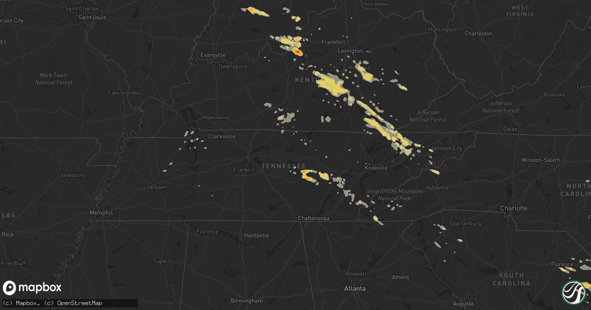
Hail Map on June 19, 2011
Get this storm
June 19 map
$229
one time, instant access
Download today. No call, no setup
Keep the $229
Bought the map and want the full workflow? Apply the entire $229 to a subscription within 7 days. None of it is wasted.
Every map, not just this one
This buys you this map. Subscription and you get every map we run, in the markets you choose from a few cities to whole states to nationwide. Plus real-time alerts the moment a storm fires.
Contact data
Name, contact info, occupancy, even credit band for addresses in the footprint. You go from where it hit to who to call.
Become the source they trust
Unlimited branding weather history reports on demand. You already have the documented answer ready for the property owner, and you are the one who showed up with it.
Property data and RoofTrace estimates
Pull up any address you have got, its value and the exact code rules for that jurisdiction, straight from One Click Code. Then RoofTrace estimates the squares, pitch, and roof value, priced the way you price.
States Impacted by Hail Map on June 19, 2011
Storm reports
Wisconsin
| Date | Description |
|---|---|
| 06/19/20114:56 PM CDT | Brief and very weak tornado |
| 06/19/20114:56 PM CDT | Brief and very weak tornado. Near the intersection of county rd dw and freedom rd there were indications...consisting of flattening of tall grass in a swirl motion...of |
Kentucky
| Date | Description |
|---|---|
| 06/19/20116:09 PM CDT | Fell near forest springs. |
| 06/19/20115:05 PM CDT | A local report indicates 1.00 inch wind near WOODVILLE |
| 06/19/20115:02 PM CDT | Half dollar to nearly golfball size hail. Late report. |
| 06/19/20115:00 PM CDT | A local report indicates 1.00 inch wind near LA CENTER |
| 06/19/20118:35 AM CDT | Three trees down in stone creek neighborhood |
| 06/19/20118:18 AM CDT | One tree was downed in junction city. |
| 06/19/20117:52 AM CDT | Trees were downed along depot street and 150 valley hill road in springfield |
| 06/19/20117:43 AM CDT | Two trees downed by thunderstorm winds along old mumfordville road north of glasgow. |
| 06/19/20117:23 AM CDT | Limbs down |
| 06/19/20117:15 AM CDT | Large tree down. |
| 06/19/20117:06 AM CDT | Shed was blown about 20 feet and destroyed on flowervale lane. |
| 06/19/20117:00 AM CDT | Trees down on coleman road. |
| 06/19/20114:05 AM CDT | Sixty to ninety trees blown down on hwy 92e near the knox county line. |
| 06/19/20112:10 AM CDT | Trees down on hwy 1809. |
| 06/19/20112:00 AM CDT | Tree down on hardbell station road near the wasioto golf course. |
| 06/19/20111:25 AM CDT | Golf ball size hail |
| 06/19/20111:15 AM CDT | Trees down on old way road. |
| 06/19/20111:10 AM CDT | Several trees down. |
| 06/19/201112:54 AM CDT | A local report indicates 1.00 inch wind near 5 E SHEPHERDSVILLE |
| 06/19/201112:52 AM CDT | Golf ball and larger size hail |
| 06/19/201112:47 AM CDT | A local report indicates 1.00 inch wind near 5 NE SHEPHERDSVILLE |
Illinois
| Date | Description |
|---|---|
| 06/19/20115:59 PM CDT | At pine and thompson roads. |
| 06/19/20115:56 PM CDT | Dime to quarter sized hail. At pine and thompson roads. |
| 06/19/20114:20 PM CDT | Quarter size hail at mound city. |
| 06/19/20116:16 AM CDT | Trees down and across warner bridge road...1 mile north of rt 17. Estimated diameter of biggest trees were 12-15 inches. Time estimated from radar. |
| 06/19/20116:16 AM CDT | Swath of damage noted starting near county roads 1000n and 7000w...extending northeast. Damage to pole barn...with multiple trees uprooted that were 2 plus feet in diam |
| 06/19/20116:14 AM CDT | Tornado touched down near 8344n route 17 in the southeast portion of bonfield. It then tracked northeast at 45 mph...dissipating/lifting near 5732n 2000n...3 miles due |
| 06/19/20115:45 AM CDT | A local report indicates 59 MPH wind near PONTIAC |
Iowa
| Date | Description |
|---|---|
| 06/19/20113:00 PM CDT | Tornado touched down in open field nearly stationary. No damage. |
| 06/19/20115:05 AM CDT | Numerous trees downed with some trees on top of houses. Power lines downed and a storage shead shifted from its foundation. Cars thrown into a ditch. Winds ripped the f |
| 06/19/20115:05 AM CDT | Track length 1/2 mile and path width of 50 yards. Estimated winds of 110 mph. Numerous trees downed with some trees on top of houses. Power lines downed and a storage s |
| 06/19/20114:10 AM CDT | Numerous six inch tree branches down. A 40 to 50 ft tree fell on top of a house. Time estimated from radar. |
| 06/19/20113:11 AM CDT | A local report indicates 1.00 inch wind near DEXTER |
| 06/19/20113:10 AM CDT | A local report indicates 1.75 inch wind near 2 E STUART |
| 06/19/20113:08 AM CDT | A local report indicates 1.50 inch wind near S LOGAN |
| 06/19/20112:50 AM CDT | Hail dented pick up truck. |
| 06/19/20111:17 AM CDT | A local report indicates 60 MPH wind near ALBIA |
| 06/19/20111:15 AM CDT | Numerous small branches and limbs down along with a few portions of larger trees. Some of these were blocking part of the road. Another tree fell onto a vehicle at the |
| 06/19/201112:56 AM CDT | At the nws office in johnston |
| 06/19/201112:53 AM CDT | Awning of camper torn off...some siding taken off house. Power out. |
| 06/19/201112:48 AM CDT | A local report indicates 1.50 inch wind near 1 E GRIMES |
| 06/19/201112:45 AM CDT | A local report indicates 62 MPH wind near 3 E CHARITON AIRPORT |
| 06/19/201112:15 AM CDT | Significant tree damage in the town of leon. An estimated 100 to 200 trees felled in town with large tree limbs littering the town. Trees fell onto the roofs of many ho |
| 06/19/201112:12 AM CDT | Heavy rain and pea hail was also being reported west of leon. |
| 06/18/201111:56 PM CDT | At the nws office in johnston |
| 06/18/201111:52 PM CDT | Four mature trees downed along with numerous four to six inch in diameter limbs. Two different powerlines downed by falling trees. An abandoned mobile home moved off it |
| 06/18/201111:15 PM CDT | A local report indicates 1.75 inch wind near SIDNEY |
| 06/18/201110:35 PM CDT | A local report indicates 1.00 inch wind near NE ARISPE |
| 06/18/201110:33 PM CDT | A local report indicates 1.50 inch wind near ARISPE |
| 06/18/201110:00 PM CDT | A local report indicates 1.00 inch wind near 4 ENE NEBRASKA CITY |
| 06/18/201110:00 PM CDT | A local report indicates 1.00 inch wind near 4 S CLARINDA |
North Carolina
| Date | Description |
|---|---|
| 06/19/20114:32 PM CDT | Nickel to quarter size hail reported in indian beach |
| 06/19/20114:27 PM CDT | Quarter to half dollar size hail reported in emerald isle beach |
| 06/19/20113:20 AM CDT | Tree down at 500 chelsie road |
| 06/19/20112:21 AM CDT | Greene county 911 center reports trees down across west greene street in snow hill. |
| 06/19/20112:20 AM CDT | Public reports nickel to quarter size hail observed in otway. |
| 06/19/20112:00 AM CDT | Beaufort asos observed a 66 knot wind gust. |
| 06/19/20112:00 AM CDT | Hanger destroyed at michael smith airport in beaufort |
| 06/19/20111:40 AM CDT | Tree down on catfish lake road |
| 06/19/20111:33 AM CDT | One tree was reported down on the corner of a house at east greenwood avenue and north saratoga street |
| 06/19/201112:40 AM CDT | Nickel to quarter size hail reported by police in warsaw. |
| 06/19/201112:30 AM CDT | One tree was reported down across hardimont road near quail hollow drive. |
| 06/19/201112:28 AM CDT | A local report indicates 1.75 inch wind near TURKEY |
| 06/19/201112:25 AM CDT | Quarter size hail in western cary. |
| 06/19/201112:20 AM CDT | One tree was reported down on a house along east park street near urban drive. |
| 06/18/201111:47 PM CDT | Dime to quarter size hail in ammon. Time estimated by radar. |
| 06/18/201111:25 PM CDT | Hail the size of quarters and very heavy rain fell in downtown wilson on main street |
| 06/18/201111:05 PM CDT | A local report indicates 74 MPH wind near 2 SSE CASHIERS |
| 06/18/201111:05 PM CDT | Windows and interior doors blown out of home. |
| 06/18/201110:50 PM CDT | Tree on powerlines at base of cowee mtn. |
| 06/18/201110:40 PM CDT | One tree down near the intersection of jones ridge road and hw-441 south. |
| 06/18/201110:35 PM CDT | Several trees down. |
| 06/18/201110:35 PM CDT | 2 trees down along hw-28 north. |
| 06/18/201110:30 PM CDT | Multiple trees down in the nantahala community. |
| 06/18/201110:20 PM CDT | Trees and power lines down county wide. |
| 06/18/201110:15 PM CDT | 2 trees down on state road 1122 in the snowbird community. |
| 06/18/201110:10 PM CDT | 2 trees down near 1214 mountain creek road. |
Indiana
| Date | Description |
|---|---|
| 06/19/201110:31 AM CDT | An nws storm damage survey confirmed that a very short lived ef-0 tornado touched down in extreme northeast perry county indiana. The 60-70 yard wide tornado touched do |
| 06/19/20117:33 AM CDT | Two trees down along state highway 56 just east of the scott county line. |
| 06/19/20117:30 AM CDT | Trees powerlines down near scottsburg |
| 06/19/20117:01 AM CDT | Trees down. |
| 06/19/20116:54 AM CDT | 3 large trees down across roadways in rural areas between 2 and 5 miles northwest of mount ayr. |
| 06/19/20114:55 AM CDT | Time estimated. |
| 06/19/20114:37 AM CDT | A local report indicates 1.00 inch wind near INDIANAPOLIS |
| 06/19/20113:55 AM CDT | Time estimated. |
| 06/19/20113:45 AM CDT | Time estimated. |
| 06/19/20113:19 AM CDT | A local report indicates 1.00 inch wind near 2 S GREENWOOD |
| 06/19/20113:00 AM CDT | On columbus st. Time estimated. |
| 06/19/20111:36 AM CDT | A local report indicates 1.25 inch wind near MITCHELL |
| 06/19/20111:29 AM CDT | A local report indicates 1.00 inch wind near MITCHELL |
| 06/19/20111:25 AM CDT | Time estimated. |
| 06/19/20111:03 AM CDT | A local report indicates 1.00 inch wind near WILLIAMS |
| 06/19/20111:00 AM CDT | Time estimated. |
Kansas
| Date | Description |
|---|---|
| 06/19/20116:17 AM CDT | A local report indicates 60 MPH wind near 10 S SHARON SPRINGS |
| 06/19/20116:17 AM CDT | Time estimate |
| 06/19/20116:17 AM CDT | Broken utility poles. Time estimate |
| 06/19/20116:10 AM CDT | Out-buildings blown down. |
| 06/19/20116:10 AM CDT | Empty grain bins and power poles blown down. Irrigation pivots blown over. Out-buildings blown down and windows broken from hail. Time approximated from radar. |
| 06/19/20116:10 AM CDT | Also blowing dirt and nickel sized hail |
| 06/19/20116:06 AM CDT | Top of grainbin blown off with tin lying alongside hwy 27. Approximately 5 irrigation pivots blown over along and west of hwy 27. Time estimated from radar. |
| 06/19/20116:06 AM CDT | Cedar windbreak severely damaged with several large trees uprooted. Semi-truck blown over and shingles blown off house. Time estimated by radar. |
| 06/18/20119:56 PM CDT | Most of the hail was quarter-size |
| 06/18/20119:54 PM CDT | A local report indicates 1.00 inch wind near MANHATTAN |
| 06/18/20119:53 PM CDT | A local report indicates 1.00 inch wind near E MANHATTAN |
| 06/18/20119:15 PM CDT | On interstate 70 at exit 303 |
| 06/18/20118:52 PM CDT | Lasted 10 mins. |
| 06/18/20118:12 PM CDT | Brief tornado reported by trained spotter |
| 06/18/20118:01 PM CDT | A local report indicates 1.00 inch wind near 4 W WHITE CITY |
| 06/18/20117:54 PM CDT | A local report indicates 2.75 inch wind near 5 ENE WOODBINE |
| 06/18/20117:52 PM CDT | A local report indicates 1.25 inch wind near 3 NE WOODBINE |
| 06/18/20117:52 PM CDT | A local report indicates 1.25 inch wind near 5 ENE WOODBINE |
| 06/18/20117:37 PM CDT | A local report indicates 1.00 inch wind near 7 S CHAPMAN |
Missouri
| Date | Description |
|---|---|
| 06/19/201112:08 AM CDT | Occurring right now. |
| 06/18/201110:07 PM CDT | Tornado north of tarkio heading east near 59 hwy |
Colorado
| Date | Description |
|---|---|
| 06/19/20116:38 PM CDT | A local report indicates 1.25 inch wind near 8 ENE CROOK |
| 06/19/20116:28 PM CDT | A local report indicates 2.50 inch wind near CROOK |
| 06/19/20116:15 PM CDT | A local report indicates 1.00 inch wind near 6 NW CROOK |
| 06/19/20115:39 PM CDT | A local report indicates 1.00 inch wind near PEETZ |
| 06/19/20115:30 AM CDT | A local report indicates 74 MPH wind near SHERIDAN LAKE |
| 06/19/20115:30 AM CDT | A local report indicates 1.00 inch wind near SHERIDAN LAKE |
| 06/19/20115:23 AM CDT | Radio tower blown down. Two 10 inch in diameter trees uprooted. Debris strewn across property. Time based off radar data. |
| 06/19/20114:30 AM CDT | A local report indicates 1.00 inch wind near 10 S EADS |
| 06/19/201112:20 AM CDT | A local report indicates 60 MPH wind near WRAY |
| 06/18/201111:48 PM CDT | A local report indicates 1.00 inch wind near YUMA |
| 06/18/201111:12 PM CDT | A local report indicates 58 MPH wind near 11 NNE AKRON |
| 06/18/201110:54 PM CDT | A local report indicates 1.00 inch wind near 2 N WOODROW |
| 06/18/20119:40 PM CDT | A local report indicates 1.75 inch wind near 8 N WAUNETA |
| 06/18/20119:18 PM CDT | Pea to quarter size hail covering the ground. Little wind at this time. |
| 06/18/20119:07 PM CDT | A local report indicates 2.00 inch wind near 12 N STRASBURG |
| 06/18/20119:04 PM CDT | A local report indicates 1.00 inch wind near 2 N PROSPECT VALLEY |
| 06/18/20118:57 PM CDT | A local report indicates 1.75 inch wind near 3 NNW LONE STAR |
| 06/18/20118:19 PM CDT | A local report indicates 1.00 inch wind near 8 NNW HOLYOKE |
| 06/18/20118:06 PM CDT | A local report indicates 2.00 inch wind near PAOLI |
| 06/18/20118:05 PM CDT | A local report indicates 70 MPH wind near FLEMING |
| 06/18/20117:30 PM CDT | A local report indicates 1.75 inch wind near 1 NW AMHERST |
| 06/18/20117:30 PM CDT | Wind gusts estimated at 60 mph |
| 06/18/20117:24 PM CDT | A local report indicates 2.00 inch wind near 5 SE JULESBURG |
| 06/18/20117:20 PM CDT | A local report indicates 2.00 inch wind near 6 SE JULESBURG |
| 06/18/20117:17 PM CDT | A local report indicates 1.25 inch wind near 6 SE SEDGWICK |
| 06/18/20117:08 PM CDT | A local report indicates 1.75 inch wind near OVID |
| 06/18/20117:01 PM CDT | Tornado on the ground for 2 minutes in open field. No damage reported. |
Florida
| Date | Description |
|---|---|
| 06/19/20116:50 PM CDT | Estimated 50 mph wind gust snapped a tree 10 feet above the ground in pine castle. |
| 06/19/20113:30 PM CDT | A thunderstorm produced a wind gust estimated at 60 mph in hialeah near the flamingo horse track. A few small trees estimated to be 8 to 9 feet tall have been knocked d |
| 06/19/20111:50 PM CDT | Skywarn spotter reported winds of at least 60 mph and pine trees down at eagle trace golf club. |
| 06/19/20111:50 PM CDT | Skywarn spotter reported half dollar size hail in coral springs. |
South Carolina
| Date | Description |
|---|---|
| 06/19/20114:30 PM CDT | East georgia rd at fd |
| 06/19/20114:28 PM CDT | A local report indicates 1.00 inch wind near FIVE FORKS |
| 06/19/20114:10 PM CDT | Enoree fd |
| 06/19/20114:09 PM CDT | Tree across road near old mcelhaney rd |
| 06/19/20114:00 PM CDT | Several trees down near the street intersection of main and croft. One tree clipped a house. Another tree fell on a couple of parked cars. |
| 06/19/20112:47 PM CDT | A local report indicates 1.25 inch wind near 2 SSW SOCASTEE |
| 06/19/20112:46 PM CDT | A local report indicates 1.00 inch wind near 2 SSW SOCASTEE |
| 06/19/20112:45 PM CDT | Trees down. |
| 06/19/20112:40 PM CDT | A local report indicates 1.00 inch wind near 2 NNE SOCASTEE |
| 06/19/20112:33 PM CDT | Tree down in the roadway on state rt 544. |
| 06/19/20112:32 PM CDT | A local report indicates 1.25 inch wind near SOCASTEE |
| 06/19/20112:28 PM CDT | A local report indicates 1.00 inch wind near 2 N SOCASTEE |
| 06/19/20112:20 PM CDT | A local report indicates 1.75 inch wind near 8 W CONWAY |
| 06/19/20112:16 PM CDT | Tree down across sc544 east bound vicinity state road 814. |
| 06/19/20111:19 PM CDT | A local report indicates 1.00 inch wind near 4 SSE FLORENCE |
| 06/19/201112:50 PM CDT | Tree down on hoyt rogers rd. |
| 06/19/20111:35 AM CDT | Roof of barn partially blown off and several large tree limbs down in the yard |
| 06/19/201112:41 AM CDT | One tree down on old abbeville highway. Time determined by radar. |
| 06/19/201112:10 AM CDT | Trees down |
| 06/19/201112:03 AM CDT | Large tree down on rocky ford road. Time determined by radar. |
| 06/19/201112:03 AM CDT | Tree blocking simpson road. Time determined by radar. |
| 06/18/201111:40 PM CDT | Tree down through house on odell drive off hwy 178. |
| 06/18/201111:33 PM CDT | Metal roof off house |
| 06/18/201111:32 PM CDT | Trees and power lines down on nicole drive near old chapman bridge. Fire started in nearby wooded area. |
| 06/18/201111:32 PM CDT | Multiple trees and power lines down along highway 11 between salem and lake keowee. |
| 06/18/201111:29 PM CDT | Trees down |
| 06/18/201111:10 PM CDT | Trees down at fish hatchery road and hwy 107. |
| 06/18/201111:03 PM CDT | Large tree down on rocky ford road. Time determined by radar. |
Wyoming
| Date | Description |
|---|---|
| 06/19/20114:19 PM CDT | On the north side of cheyenne. |
| 06/19/20114:19 PM CDT | A local report indicates 1.25 inch wind near 8 NE CHEYENNE |
| 06/19/20114:07 PM CDT | Mostly pea size. |
Tennessee
| Date | Description |
|---|---|
| 06/19/20116:25 PM CDT | Dime to quarter sized hail |
| 06/19/20116:04 PM CDT | Baseball size hail was reported in the oak grove community at state highway 174 and pleasant grove road. |
| 06/19/20115:59 PM CDT | A local report indicates 1.00 inch wind near 2 SE WESTMORELAND |
| 06/19/20115:57 PM CDT | Largest hail measured at 2.25 inches |
| 06/19/20115:47 PM CDT | A local report indicates 1.75 inch wind near 5 N WESTMORELAND |
| 06/19/20112:35 PM CDT | A local report indicates 1.00 inch wind near POWELL |
| 06/19/201111:45 AM CDT | A few trees down. |
| 06/19/20114:00 AM CDT | Numerous trees down across the eastern portions of the county. |
| 06/19/20113:30 AM CDT | One tree down on lonesome pine trail. |
| 06/19/20113:30 AM CDT | Trees down on little creek |
| 06/19/20113:20 AM CDT | One tree down |
| 06/19/20113:03 AM CDT | Trees down on highway 25e. |
| 06/19/20112:45 AM CDT | Multiple trees down |
| 06/18/20119:55 PM CDT | Tree down on home at 108 mason street. |
| 06/18/20119:55 PM CDT | Tree down on home. |
| 06/18/20119:40 PM CDT | A local report indicates 1.00 inch wind near 5 SSE MADISONVILLE |
| 06/18/20119:25 PM CDT | One tree down on big spring gap rd. |
| 06/18/20119:05 PM CDT | A local report indicates 1.00 inch wind near TEN MILE |
| 06/18/20119:00 PM CDT | Golfball size hail reported by public on hodges ferry road. |
| 06/18/20119:00 PM CDT | A local report indicates 2.00 inch wind near SPARTA |
| 06/18/20118:50 PM CDT | Few tree limbs down. |
| 06/18/20118:28 PM CDT | 1 inch diameter hail was reported. |
| 06/18/20118:15 PM CDT | Golfball hail reported by public in de rossett in white county. |
| 06/18/20118:00 PM CDT | A local report indicates 1.75 inch wind near CROSSVILLE |
| 06/18/20117:55 PM CDT | A local report indicates 1.25 inch wind near SPARTA |
| 06/18/20117:45 PM CDT | Partial roof was blown off a building at 265 south jefferson avenue. |
| 06/18/20117:45 PM CDT | A local report indicates 1.00 inch wind near COOKEVILLE |
| 06/18/20117:42 PM CDT | Several trees were blown over near the intersection of willow avenue and west cemetery road. |
| 06/18/20117:36 PM CDT | A local report indicates 1.00 inch wind near ALGOOD |
| 06/18/20117:36 PM CDT | A local report indicates 2.00 inch wind near COOKEVILLE |
| 06/18/20117:35 PM CDT | A local report indicates 1.00 inch wind near COOKEVILLE |
| 06/18/20117:35 PM CDT | A local report indicates 60 MPH wind near 3 NE COOKEVILLE |
| 06/18/20117:30 PM CDT | A local report indicates 1.75 inch wind near COOKEVILLE |
| 06/18/20117:30 PM CDT | Several trees and powerlines down in and around algood and northeast of cookeville |
| 06/18/20117:28 PM CDT | A local report indicates 1.00 inch wind near COOKEVILLE |
| 06/18/20117:26 PM CDT | A local report indicates 1.75 inch wind near 5 N COOKEVILLE |
| 06/18/20117:25 PM CDT | A local report indicates 1.25 inch wind near 2 N COOKEVILLE |
| 06/18/20117:14 PM CDT | A local report indicates 1.00 inch wind near GAINESBORO |
| 06/18/20117:04 PM CDT | A local report indicates 1.00 inch wind near GAINESBORO |
Nebraska
| Date | Description |
|---|---|
| 06/19/20116:48 PM CDT | Chase county sheriff reported tornado 8 miles south of waneta |
| 06/19/20116:47 PM CDT | Tornado was in an open field and lasted 4 minutes. |
| 06/19/20116:44 PM CDT | Tornado lasted for 3 minutes. Multiple sightings of this same tornado. |
| 06/19/20116:38 PM CDT | A local report indicates 1.75 inch wind near 6 N STUART |
| 06/19/20116:36 PM CDT | A local report indicates 1.75 inch wind near 5 NNE STUART |
| 06/19/20116:22 PM CDT | Marble to ping pong ball sized hail partially covering the ground |
| 06/19/20116:02 PM CDT | A local report indicates 2.75 inch wind near 10 WNW IMPERIAL |
| 06/19/20116:02 PM CDT | The hail lasted for 20 minutes. |
| 06/19/20115:53 PM CDT | Quarters and half dollars size hail reported in newport. |
| 06/19/20115:25 PM CDT | Public reported quarter sized hail 5 miles ssw of newport |
| 06/19/20113:50 PM CDT | Strong winds over 60 mph caused extensive large tree damage. Structural damage to a home by a fallen tree and pivot irrigation system overturned. |
| 06/19/20112:55 PM CDT | A local report indicates 1.50 inch wind near 8 S KIMBALL |
| 06/19/20119:23 AM CDT | Imperial asos reported a wind gust of 77 mph. Delayed report. |
| 06/19/20113:30 AM CDT | A local report indicates 60 MPH wind near CENTRAL CITY |
| 06/19/20113:27 AM CDT | A local report indicates 60 MPH wind near 2 E CHAPMAN |
| 06/19/20112:35 AM CDT | Still a few stones falling at 241 am. |
| 06/19/20112:30 AM CDT | Estimated wind gusts up to 60 mph. |
| 06/19/20112:20 AM CDT | Delayed report of hail which caused broken siding on their home. Time estimated from radar. |
| 06/19/20112:11 AM CDT | A local report indicates 1.00 inch wind near 3 W KEARNEY |
| 06/19/20112:05 AM CDT | Delayed report from public relayed by omaha national weather service office. |
| 06/19/20112:02 AM CDT | A local report indicates 1.75 inch wind near 2 W SILVER CREEK |
| 06/19/20112:02 AM CDT | Corrected location from original report |
| 06/19/20112:00 AM CDT | 2 large trees blown down in city park. |
| 06/19/20111:44 AM CDT | Old elevator blown across highway 30. Debris covering the road between clarks and silver creek. Power lines down in clarks and power is out to the town of clarks. |
| 06/19/20111:44 AM CDT | Corrected location from original report to put in merrick county. Old elevator blown across highway 30. Debris covering the road between clarks and silver creek. Power |
| 06/19/20111:36 AM CDT | Chase county sheriff reported golf ball sized hail and very heavy rain in wauneta |
| 06/19/20111:30 AM CDT | Delayed report via nerain observer. Golf ball size started around 130am and lasted 15-20 minutes. |
| 06/19/20111:17 AM CDT | A local report indicates 1.50 inch wind near 12 S ELWOOD |
| 06/19/20111:16 AM CDT | A local report indicates 1.25 inch wind near 6 N ARAPAHOE |
| 06/19/20111:15 AM CDT | A local report indicates 1.25 inch wind near 10 S ELWOOD |
| 06/19/20111:13 AM CDT | 60 to 65 mph winds...heavy rain and nickel size hail. Several 6 inch diameter tree limbs down on highway 183. |
| 06/19/20111:10 AM CDT | Two inch diameter tree limbs down. |
| 06/19/20111:08 AM CDT | Large tree blown down on power lines. Six center pivots flipped over. |
| 06/19/201112:46 AM CDT | Winds estimated at 60 to 70 mph. |
| 06/19/201112:35 AM CDT | 2-3 inch diameter tree limbs down. Pea to penny size hail. |
| 06/19/201112:14 AM CDT | Reports of sky lights being broke out also. |
| 06/19/201112:01 AM CDT | A local report indicates 1.00 inch wind near 13 SE HAYES CENTER |
| 06/18/201111:55 PM CDT | Time of report was estimated. |
| 06/18/201111:55 PM CDT | The hail damaged siding. |
| 06/18/201111:53 PM CDT | A local report indicates 2.50 inch wind near COTESFIELD |
| 06/18/201111:40 PM CDT | Delayed report of hail and 60 mph winds from nebraska rainfall assessment and information network observer. Time estimated from radar. |
| 06/18/201111:40 PM CDT | A local report indicates 1.50 inch wind near 7 SE ARNOLD |
| 06/18/201111:32 PM CDT | A local report indicates 1.75 inch wind near UNION |
| 06/18/201111:15 PM CDT | A local report indicates 1.75 inch wind near 5 NE CURTIS |
| 06/18/201110:45 PM CDT | Delayed report. Large hail to ping pong ball size cracked truck windshield and punched holes in vinyl siding on home. |
| 06/18/201110:37 PM CDT | A local report indicates 1.50 inch wind near 2 SW ATLANTA |
| 06/18/201110:37 PM CDT | Corrected for location. |
| 06/18/201110:36 PM CDT | A local report indicates 1.75 inch wind near CAMBRIDGE |
| 06/18/201110:35 PM CDT | A local report indicates 1.75 inch wind near IMPERIAL |
| 06/18/201110:30 PM CDT | Delayed report. Time estimated from radar. |
| 06/18/201110:30 PM CDT | A local report indicates 2.00 inch wind near NEBRASKA CITY |
| 06/18/201110:30 PM CDT | Hail ranged from quarter to golf ball size - with some hail as large as tennis balls. Roof damage at residence. |
| 06/18/201110:30 PM CDT | A local report indicates 1.00 inch wind near 12 NE HAYES CENTER |
| 06/18/201110:25 PM CDT | Chase county sheriff reported golf ball and baseball sized hail in champion |
| 06/18/201110:15 PM CDT | Delayed report from yesterday evening. |
| 06/18/201110:13 PM CDT | A local report indicates 1.50 inch wind near 1 N EDISON |
| 06/18/201110:12 PM CDT | A local report indicates 2.50 inch wind near 4 W ARAPAHOE |
| 06/18/201110:12 PM CDT | A local report indicates 2.50 inch wind near 4 E ARAPAHOE |
| 06/18/201110:08 PM CDT | A local report indicates 1.75 inch wind near ARAPAHOE |
| 06/18/201110:08 PM CDT | Hail with 60 mph wind gusts. |
| 06/18/201110:05 PM CDT | Delayed report. Siding and roof damage caused by golf ball sized hail. |
| 06/18/201110:05 PM CDT | A local report indicates 65 MPH wind near 2 N EDISON |
| 06/18/201110:03 PM CDT | Golf ball sized hailed reported near gosper county line |
| 06/18/201110:00 PM CDT | Delayed report of pea to quarter size hail. Storm total rainfall was 1.70 inches at this location. |
| 06/18/201110:00 PM CDT | Delayed report of hail the size of quarters with a few half dollar sized stones. |
| 06/18/201110:00 PM CDT | Hail fell around 10-1015 pm. |
| 06/18/201110:00 PM CDT | Estimated around 10 pm cdt with extensive crop damage from three separate storm cells. |
| 06/18/201110:00 PM CDT | Quarter to half dollar sized hail caused siding damage on west side of home along with one broken window. |
| 06/18/201110:00 PM CDT | A local report indicates 1.75 inch wind near 9 NE BROKEN BOW |
| 06/18/20119:59 PM CDT | A local report indicates 2.50 inch wind near ARAPAHOE |
| 06/18/20119:57 PM CDT | A local report indicates 1.50 inch wind near 11 S NORTH PLATTE |
| 06/18/20119:49 PM CDT | A local report indicates 1.25 inch wind near 10 S NORTH PLATTE |
| 06/18/20119:40 PM CDT | Garage and barn destroyed. Trees 1.5 to 2 feet in diameter are down. Power lines are also down. |
| 06/18/20119:38 PM CDT | 45 to 50 mph winds with gusts of 65 mph. Also rotation in storm. |
| 06/18/20119:38 PM CDT | A local report indicates 1.00 inch wind near NEBRASKA CITY |
| 06/18/20119:30 PM CDT | Estimated largest hail to be slightly larger than a golfball. Reported extensive damage with all windows destroyed as well as significant crop damage. |
| 06/18/20119:30 PM CDT | Main transmission lines blown down just north of cambridge. Air conditioning units blown off of hospital in cambridge. |
| 06/18/20119:23 PM CDT | Imperial asos reported a wind gust of 77 mph. Delayed report. |
| 06/18/20119:05 PM CDT | Time is estimated...this is a delayed report. |
| 06/18/20119:00 PM CDT | A local report indicates 1.00 inch wind near 7 SW HAYES CENTER |
| 06/18/20118:59 PM CDT | A local report indicates 1.25 inch wind near 6 NE ARNOLD |
| 06/18/20118:57 PM CDT | Multiple tornadoes reported |
| 06/18/20118:40 PM CDT | A local report indicates 1.75 inch wind near STOCKVILLE |
| 06/18/20118:20 PM CDT | Multiple tornadoes reported |
| 06/18/20118:15 PM CDT | A local report indicates 1.00 inch wind near W BRULE |
| 06/18/20117:45 PM CDT | Golf ball sized hail 9 se of hayes center |
| 06/18/20117:40 PM CDT | A local report indicates a tornado near 6 S PALISADE |
| 06/18/20117:39 PM CDT | A local report indicates 1.00 inch wind near 4 S BIG SPRINGS |
| 06/18/20117:30 PM CDT | Time of report corrected. |
| 06/18/20117:12 PM CDT | Public reported golf ball sized hail 10 s of hayes center |
| 06/18/20117:12 PM CDT | Public reported golf ball sized hail 10 sw of hayes center |
| 06/18/20117:06 PM CDT | Public reported a few hail stones the size of a quarter...but most were the size of a large marble. |
| 06/18/20117:04 PM CDT | A local report indicates a tornado near 13 NNE BENKELMAN |
Cities Impacted by Hail Map on June 19, 2011
- Palisade, NE
- Hayes Center, NE
- Elwood, NE
- Maywood, NE
- Edison, NE
- Holdrege, NE
- McCook, NE
- Elsie, NE
- Stockville, NE
- Haigler, NE
- Bartley, NE
- Farnam, NE
- Eustis, NE
- Moorefield, NE
- Arapahoe, NE
- Culbertson, NE
- Bertrand, NE
- Wray, CO
- Holbrook, NE
- Indianola, NE
- Wauneta, NE
- Cambridge, NE
- Holyoke, CO
- Champion, NE
- Atlanta, NE
- Parks, NE
- Enders, NE
- Curtis, NE
- Oxford, NE
- Maxwell, NE
- Benkelman, NE
- Imperial, NE
- Seneca, IL
- Morris, IL
- Newark, IL
- Marseilles, IL
- Robbins, TN
- Paxton, IL
- Fremont, IA
- Cedar, IA
- Mount Olive, NC
- Liberty, MO
- Callaway, NE
- Waukee, IA
- Van Meter, IA
- West Des Moines, IA
- Cumming, IA
- Dover, TN
- Buda, IL
- Bradford, IL
- Sheffield, IL
- Neponset, IL
- Stilesville, IN
- Monrovia, IN
- Ashland, NE
- Lacona, IA
- Chariton, IA
- Blair, NE
- Kennard, NE
- Iroquois, IL
- Watseka, IL
- Sheldon, IL
- Sparta, TN
- Doyle, TN
- Kim, CO
- Memphis, MO
- Arbela, MO
- Menlo, IA
- Cedar Island, NC
- Prague, NE
- Cedar Bluffs, NE
- Colon, NE
- Malmo, NE
- Morse Bluff, NE
- Fremont, NC
- Stantonsburg, NC
- Waynesburg, KY
- Gravel Switch, KY
- Kings Mountain, KY
- Springfield, KY
- Middleburg, KY
- Yosemite, KY
- Hustonville, KY
- Eubank, KY
- Bethelridge, KY
- Stanford, KY
- Parksville, KY
- Liberty, KY
- Crab Orchard, KY
- Lebanon, KY
- Elk Horn, KY
- Bradfordsville, KY
- Bean Station, TN
- Yutan, NE
- Valley, NE
- Blakesburg, IA
- Unionville, IA
- Drakesville, IA
- Strasburg, CO
- Bennett, CO
- Wallace, KS
- Sharon Springs, KS
- Science Hill, KY
- Indianapolis, IN
- Elk Horn, IA
- Marne, IA
- Avoca, IA
- Harlan, IA
- Kimballton, IA
- Walnut, IA
- Branson, CO
- Dickens, NE
- Wellfleet, NE
- Albia, IA
- Moravia, IA
- Axtell, NE
- Fairland, IN
- Louisville, KY
- Elizabeth, IN
- Lanesville, IN
- New Albany, IN
- Las Animas, CO
- La Junta, CO
- Murdock, NE
- Rosalie, NE
- Lyons, NE
- Herman, NE
- Arlington, NE
- Covington, IN
- Kingman, IN
- Ordway, CO
- Olney Springs, CO
- Unionville, MO
- Coatsville, MO
- Pulaski, IA
- Livonia, MO
- Udell, IA
- Bloomfield, IA
- Exline, IA
- Moulton, IA
- Centerville, IA
- Keosauqua, IA
- Silver Creek, NE
- Chavies, KY
- Lost Creek, KY
- Eagleville, MO
- Hatfield, MO
- Sparland, IL
- Marquette, NE
- Central City, NE
- Nodaway, IA
- Corning, IA
- Colchester, IL
- Plymouth, IL
- Clarks, NE
- Fullerton, NE
- Woodrow, CO
- Keota, IA
- Spencer, TN
- San Jose, IL
- Emden, IL
- Crook, CO
- Knoxville, IA
- La Moille, IL
- Arlington, IL
- Easley, SC
- Erin, TN
- Vail, IA
- Tazewell, TN
- Sneedville, TN
- Scotia, NE
- Loup City, NE
- Saint Paul, NE
- Elba, NE
- North Loup, NE
- Wolbach, NE
- Ashton, NE
- Edina, MO
- Wyaconda, MO
- Rutledge, MO
- La Belle, MO
- Knox City, MO
- Ithaca, NE
- Florence, SC
- Conway, SC
- Myrtle Beach, SC
- Broken Bow, NE
- Mount Ayr, IA
- Benton, IA
- Diagonal, IA
- Milan, IL
- Sherrard, IL
- Effingham, SC
- Mead, NE
- Wahoo, NE
- Saint Patrick, MO
- Kahoka, MO
- Cheyenne, WY
- Dodge, NE
- Hordville, NE
- Rose Hill, IA
- Delta, IA
- La Harpe, IL
- Dix, NE
- Palmer, NE
- Milan, MO
- Logan, IA
- Persia, IA
- Allerton, IA
- Humeston, IA
- Corydon, IA
- Columbus, NE
- Dallas City, IL
- Snow Hill, NC
- Wapello, IA
- Morning Sun, IA
- Yuma, CO
- Richmond, KY
- Ellston, IA
- Tingley, IA
- Shannon City, IA
- Guernsey, IA
- Sidney, IA
- Cheraw, CO
- Rocky Ford, CO
- London, KY
- Orleans, IN
- Mitchell, IN
- Toulon, IL
- Hamlin, IA
- Exira, IA
- Audubon, IA
- Bourbonnais, IL
- Barnes City, IA
- Montezuma, IA
- New Sharon, IA
- Roggen, CO
- Merna, NE
- Brady, NE
- Gothenburg, NE
- Anselmo, NE
- Arnold, NE
- Grand Ridge, IL
- Ottawa, IL
- Streator, IL
- Des Moines, IA
- Carlisle, IA
- Glasgow, KY
- Lucas, KY
- Scottsville, KY
- Plattsmouth, NE
- Casey, IA
- Dexter, IA
- Stuart, IA
- Rogersville, TN
- Faison, NC
- Mossville, IL
- Chillicothe, IL
- Watkins, CO
- Winona, KS
- Wellman, IA
- Gresham, SC
- Webster, IA
- Sigourney, IA
- Nichols, SC
- Ashkum, IL
- Clifton, IL
- Pikeville, TN
- Cameron, MO
- Fairdale, KY
- Shepherdsville, KY
- Brooks, KY
- Mount Washington, KY
- Gretna, NE
- Bellwood, NE
- Shelby, NE
- Belgrade, NE
- Genoa, NE
- Veedersburg, IN
- Winterset, IA
- Edward, NC
- Blounts Creek, NC
- Aurora, NC
- Pineville, KY
- Williamsburg, KY
- Harrogate, TN
- Calvin, KY
- Barbourville, KY
- Middlesboro, KY
- Rockholds, KY
- Cumberland Gap, TN
- Bryants Store, KY
- Corbin, KY
- Kankakee, IL
- Gravity, IA
- New Market, IA
- Bedford, IA
- Clearfield, IA
- Clarinda, IA
- Sharpsburg, IA
- Mohawk, TN
- Midway, TN
- North Bend, NE
- Towanda, IL
- Junction City, KS
- Dwight, KS
- White City, KS
- Missouri Valley, IA
- Monterey, TN
- Eckley, CO
- Venango, NE
- Henry, IL
- Putnam, IL
- Tiskilwa, IL
- Williams, IN
- Shoals, IN
- Bargersville, IN
- Martinsville, IN
- Morgantown, IN
- Keystone, NE
- Paxton, NE
- Crowley, CO
- Denison, IA
- Manilla, IA
- Swink, CO
- Wiley, CO
- Eads, CO
- McClave, CO
- Tribune, KS
- Hasty, CO
- Sheridan Lake, CO
- Weskan, KS
- Arlington, CO
- Afton, IA
- Johnston, IA
- Farragut, IA
- Riverton, IA
- Shenandoah, IA
- Basco, IL
- Corydon, IN
- New Salisbury, IN
- Ramsey, IN
- Fort Morgan, CO
- Otis, CO
- McKee, KY
- Berea, KY
- Irvine, KY
- Panora, IA
- Plano, IA
- Seymour, IA
- Promise City, IA
- Lafayette, TN
- Wallace, NE
- Pamplico, SC
- Timmonsville, SC
- Oakland, KY
- Smiths Grove, KY
- Bowling Green, KY
- Edelstein, IL
- Dunlap, IL
- Princeville, IL
- Speer, IL
- Wyoming, IL
- Campbellsburg, IN
- Loogootee, IN
- Crane, IN
- Funk, NE
- Bonaparte, IA
- Mount Sterling, IA
- Hillsboro, IA
- Augusta, IL
- Franklin, NC
- Georgetown, KY
- Saint Charles, IA
- North Platte, NE
- Clearmont, MO
- Burlington Junction, MO
- Lillington, NC
- Angier, NC
- Spring City, TN
- Rockwood, TN
- Skidmore, MO
- Clinton, NC
- Turkey, NC
- Magnolia, NC
- Warsaw, NC
- Chula, MO
- Galva, IL
- Kewanee, IL
- Elmwood, NE
- Palmyra, NE
- Eagle, NE
- Piper City, IL
- Reddick, IL
- Danforth, IL
- Buckingham, IL
- Chebanse, IL
- Herscher, IL
- Cabery, IL
- Gilman, IL
- Atkinson, NE
- West Point, NE
- David City, NE
- Fairfax, MO
- Earlham, IA
- Haxtun, CO
- Amherst, CO
- Depauw, IN
- Milltown, IN
- Queen City, MO
- Downing, MO
- Shelton, NE
- Kenesaw, NE
- Thorn Hill, TN
- Mooresburg, TN
- Blandinsville, IL
- Hershey, NE
- Metamora, IL
- East Peoria, IL
- Peoria, IL
- Avoca, NE
- Union, NE
- Randolph, IA
- Imogene, IA
- Thurman, IA
- Nehawka, NE
- Percival, IA
- Otoe, NE
- Hamburg, IA
- Nebraska City, NE
- Greenville, SC
- Carthage, IL
- Greeley, NE
- Quebeck, TN
- Perrysville, IN
- Wood River, NE
- Pleasant Hill, IA
- Ansley, NE
- Westerville, NE
- Bradley, IL
- Westmoreland, TN
- Good Hope, IL
- Bushnell, IL
- Greeneville, TN
- McLean, IL
- Stanford, IL
- Armington, IL
- Ceresco, NE
- Milton, IA
- Douds, IA
- Manhattan, KS
- Omaha, NE
- Truro, IA
- New Virginia, IA
- Gilson, IL
- Dahinda, IL
- Essex, IL
- Bonfield, IL
- Wilmington, IL
- Memphis, NE
- Atlantic, IA
- Mason City, IL
- Forest City, IL
- Easton, IL
- Keenesburg, CO
- Mosheim, TN
- Bulls Gap, TN
- Cozad, NE
- Warne, NC
- Brasstown, NC
- Hayesville, NC
- Murphy, NC
- Cookeville, TN
- Rogers, NE
- Linwood, NE
- Louisville, NE
- Weeping Water, NE
- Kimball, NE
- New Raymer, CO
- Model, CO
- Rock Island, TN
- Marion, SC
- Hollywood, FL
- Eddyville, IA
- Sidney, NE
- Marshall, IN
- Bloomingdale, IN
- Wilson, NC
- Burlington, IA
- West Burlington, IA
- Saint Marys, IA
- Prole, IA
- Griswold, IA
- Princeton, IL
- Bureau, IL
- Wyanet, IL
- Brush, CO
- Akron, CO
- Linden, TN
- Lancaster, KY
- Miracle, KY
- Creston, IA
- Lenox, IA
- Pender, NE
- Junction City, KY
- Franklin, IN
- Greenwood, IN
- Windsor Heights, IA
- Searsboro, IA
- Grinnell, IA
- Springfield, NE
- King City, MO
- Oakville, IA
- Riverside, IA
- Kalona, IA
- Somerset, KY
- Bardstown, KY
- Joy, IL
- New Boston, IL
- Carlock, IL
- Sublette, IL
- Ohio, IL
- Van Orin, IL
- Ewing, VA
- Westside, IA
- Wall Lake, IA
- Breda, IA
- Odebolt, IA
- Hooper, NE
- Comstock, NE
- Walton, NE
- Harrells, NC
- Elizabethtown, NC
- Garland, NC
- Grand Island, NE
- Snyder, CO
- Parnell, IA
- What Cheer, IA
- Brooklyn, IA
- Malcom, IA
- Fremont, NE
- Scribner, NE
- Winslow, NE
- Ames, NE
- Fontanelle, IA
- Leland, IL
- Osceola, NE
- Monroe, NE
- Oakland, NE
- Derby, IA
- Lamoni, IA
- Garden Grove, IA
- Leon, IA
- Russell, IA
- Millerton, IA
- Weldon, IA
- Kellerton, IA
- Grand River, IA
- Decatur, IA
- Van Wert, IA
- Minooka, IL
- Schuyler, NE
- Newport, NC
- Siler, KY
- Frakes, KY
- Speedwell, TN
- New Tazewell, TN
- Morristown, TN
- Whitesburg, TN
- Russellville, TN
- Adair, IA
- Guthrie Center, IA
- Anita, IA
- Wilcox, NE
- Lindsay, NE
- Salem, IA
- Walthill, NE
- Stuart, NE
- Atlanta, IL
- Orleans, NE
- Kearney, NE
- Loomis, NE
- Elm Creek, NE
- Verona, IL
- Murray, IA
- Morehead City, NC
- Orrick, MO
- Masonic Home, KY
- Nauvoo, IL
- Niota, IL
- Hamilton, IL
- Mooresville, IN
- Whiteland, IN
- Sutter, IL
- Washington, IL
- Shelbyville, IN
- Hubert, NC
- Stella, NC
- Maysville, NC
- Crescent City, IL
- Albany, MO
- Young Harris, GA
- Hiawassee, GA
- Iowa City, IA
- Lone Tree, IA
- Hills, IA
- Coralville, IA
- Deep River, IA
- Coxs Creek, KY
- Downs, IL
- Le Roy, IL
- Craig, NE
- Onarga, IL
- Hemingway, SC
- Marshall, NC
- Mars Hill, NC
- Nickerson, NE
- Rising City, NE
- Marysville, IN
- Underwood, IN
- Nabb, IN
- Lexington, IN
- Garner, NC
- Polk City, IA
- Madrid, IA
- Rock Port, MO
- Iliff, CO
- Lemoyne, NE
- Lineville, IA
- Hopkins, MO
- Smithfield, IL
- Ellisville, IL
- Cuba, IL
- Minden, NE
- La Vista, NE
- Boys Town, NE
- Howells, NE
- Stanton, NE
- Clarkson, NE
- Manzanola, CO
- Fowler, CO
- Davis City, IA
- Blythedale, MO
- Pine Village, IN
- West Lafayette, IN
- Westpoint, IN
- Otterbein, IN
- Williamsport, IN
- Attica, IN
- Galesburg, IL
- Woodhull, IL
- New Windsor, IL
- Rio, IL
- Oneida, IL
- Alpha, IL
- North Henderson, IL
- Martinton, IL
- Defiance, IA
- Murray, NE
- Warsaw, IL
- Alexandria, MO
- Jackson, KY
- Rowdy, KY
- Hazard, KY
- Whick, KY
- Wiota, IA
- Boston, KY
- New Haven, KY
- Cainsville, MO
- Hale, MO
- Gray Court, SC
- Enoree, SC
- Redfield, IA
- Linden, IA
- Eminence, KY
- New Castle, KY
- Underwood, IA
- McClelland, IA
- Council Bluffs, IA
- North Liberty, IA
- Belton, SC
- Pelzer, SC
- Paris, TN
- Emerald Isle, NC
- Atlantic Beach, NC
- Salter Path, NC
- Montezuma, IN
- Trinidad, CO
- Lucas, IA
- Montrose, IA
- Tennessee, IL
- Elvaston, IL
- Keokuk, IA
- Macomb, IL
- Gibson, IA
- Gray, KY
- Keavy, KY
- Lily, KY
- Greenfield, IA
- Boelus, NE
- Dannebrog, NE
- Farwell, NE
- Doniphan, NE
- Winchester, KY
- Aledo, IL
- Campton, KY
- Adolphus, KY
- Sutherland, NE
- Thayer, IA
- Julesburg, CO
- Pella, IA
- Lynnville, IA
- Sully, IA
- Monmouth, IL
- Oquawka, IL
- Granville, IL
- Standard, IL
- McNabb, IL
- Wever, IA
- Danville, IA
- West Point, IA
- Kenansville, NC
- Bethpage, TN
- Chatsworth, IL
- Bellevue, NE
- Smithville, TN
- Stockport, IA
- Donnellson, IA
- Farmington, IA
- Monticello, KY
- Alpha, KY
- Grimes, IA
- Urbandale, IA
- Clive, IA
- Granger, IA
- Kirksville, MO
- Clinton, TN
- Powell, TN
- Oxford, IN
- Boswell, IN
- Templeton, IN
- Jamesport, MO
- Crossville, TN
- Mendota, IL
- Roca, NE
- Elkhart, IA
- Tekamah, NE
- West Branch, IA
- Richmond, MO
- Falmouth, KY
- Henryville, IN
- Otisco, IN
- Chillicothe, MO
- La Fayette, IL
- Savannah, MO
- Rea, MO
- Earling, IA
- Tellico Plains, TN
- Avon, SD
- Humphrey, NE
- Stapleton, NE
- Mullins, SC
- Lancaster, MO
- Rossville, IL
- Coal City, IL
- Dover, NC
- Crothersville, IN
- Brownstown, IN
- Duff, TN
- Beulaville, NC
- Sheridan, MO
- Ridgeway, MO
- Harrodsburg, KY
- Birmingham, IA
- Paragon, IN
- Neola, IA
- Green City, MO
- Bryson City, NC
- Annawan, IL
- Atkinson, IL
- Gibbon, NE
- Selma, NC
- Gallatin, MO
- Fort Riley, KS
- Troy Grove, IL
- Danville, IL
- Cayuga, IN
- Georgetown, IL
- Cissna Park, IL
- Kenly, NC
- Lucama, NC
- Maitland, MO
- Mound City, MO
- Peru, IA
- Orient, IA
- Clayton, NC
- Limestone, TN
- Chuckey, TN
- Grandview, TN
- Massena, IA
- Coin, IA
- Northboro, IA
- Ellsworth, IL
- Archer, NE
- Phillips, NE
- Chapman, NE
- Saint Libory, NE
- North English, IA
- South English, IA
- Ogallala, NE
- Canton, IL
- Albany, KY
- Jamestown, KY
- Syracuse, NE
- Essex, IA
- Yorktown, IA
- Unadilla, NE
- Blanchard, IA
- Tabor, IA
- Dunbar, NE
- Miami, FL
- Middletown, IA
- Norwalk, IA
- Indianola, IA
- Danville, KY
- Lostant, IL
- Tonica, IL
- Sterling, CO
- Brooklyn, IN
- Gosport, IN
- Media, IL
- Stronghurst, IL
- Carman, IL
- Beaverville, IL
- Ravenna, NE
- Litchfield, NE
- Hazard, NE
- Manley, NE
- Green Road, KY
- Hinkle, KY
- Girdler, KY
- Kempton, IL
- Shelby, IA
- Portsmouth, IA
- Perry, IA
- Hillsboro, IN
- Waynetown, IN
- Ovid, CO
- Big Springs, NE
- Chappell, NE
- Osceola, IA
- Woodbine, IA
- Papillion, NE
- Sargent, NE
- Crescent, IA
- Altoona, IA
- Runnells, IA
- Mitchellville, IA
- Hopedale, IL
- Needham, IN
- Beech Grove, IN
- Stinesville, IN
- Clayton, IN
- Ellettsville, IN
- West Newton, IN
- Quincy, IN
- Camby, IN
- Plainfield, IN
- Bloomington, IN
- Polk, NE
- Fort Calhoun, NE
- Honey Creek, IA
- Platte Center, NE
- Duncan, NE
- Weston, NE
- Bruno, NE
- Saint Edward, NE
- Cedar Rapids, NE
- Bennington, NE
- Minden, IA
- Panama, IA
- Kirkman, IA
- Stromsburg, NE
- Modale, IA
- Irwin, IA
- Brookfield, MO
- Sumner, MO
- Stamping Ground, KY
- Fountain Run, KY
- Loris, SC
- Astoria, IL
- Niobrara, NE
- Springfield, SD
- Smithfield, NE
- Arcadia, NE
- Ord, NE
- Delavan, IL
- Galt, MO
- Marietta, IL
- Macy, NE
- Richland, IA
- Weldona, CO
- Malden, IL
- West Brooklyn, IL
- Holly Springs, NC
- Fuquay Varina, NC
- Havana, IL
- Union Star, MO
- Helena, MO
- Potter, NE
- Apex, NC
- Naper, NE
- Ware Shoals, SC
- Laurens, SC
- Amity, MO
- Maysville, MO
- Humphreys, MO
- Ankeny, IA
- Williamsburg, IA
- Sciota, IL
- Avon, IL
- Prairie City, IL
- Roseville, IL
- Etowah, TN
- Bogard, MO
- Heidrick, KY
- Artemus, KY
- Hialeah, FL
- Dow City, IA
- Cove City, NC
- New Bern, NC
- Excello, MO
- Cary, NC
- Manhattan, IL
- Manteno, IL
- Fisher, IL
- Foosland, IL
- Newport, NE
- Livingston, TN
- Pattonsburg, MO
- Hillrose, CO
- Novinger, MO
- Greenwood, NE
- South Bend, NE
- Havelock, NC
- Bridgewater, IA
- Tarkio, MO
- Ravenna, KY
- Linneus, MO
- Purdin, MO
- Red Boiling Springs, TN
- East Galesburg, IL
- Knoxville, IL
- New London, IA
- Clarkrange, TN
- Irvington, KY
- Teachey, NC
- Kellogg, IA
- Russell Springs, KY
- Hudson, IL
- Beattyville, KY
- Piedmont, SC
- Summer Shade, KY
- Stoney Fork, KY
- Arjay, KY
- Woodbine, KY
- Bimble, KY
- Fourmile, KY
- Hulen, KY
- Flat Lick, KY
- Rutledge, TN
- Washburn, TN
- Grand Mound, IA
- Delmar, IA
- Saint Augustine, IL
- Webster, KY
- Kidder, MO
- Viola, IL
- Reynolds, IL
- Slater, IA
- Campbellsville, KY
- Odessa, MO
- West Liberty, IA
- Carson, IA
- Maquon, IL
- Valparaiso, NE
- Wallins Creek, KY
- Coldiron, KY
- Padroni, CO
- Pompano Beach, FL
- Green Valley, IL
- Calypso, NC
- Zebulon, NC
- Middlesex, NC
- Sims, NC
- Scottsburg, IN
- Plattsburg, MO
- Trenton, MO
- Wayland, MO
- Rutland, IL
- Hudson, CO
- Walling, TN
- Austin, IN
- Melrose, IA
- Robbinsville, NC
- Bethany, MO
- New Hampton, MO
- Tompkinsville, KY
- Wiggins, CO
- Keswick, IA
- Topeka, IL
- Mount Pleasant, IA
- Mount Union, IA
- Craig, MO
- Avon, IN
- Fairview, IL
- Tina, MO
- Moorhead, IA
- Abie, NE
- Brayton, IA
- Brainard, NE
- Waverly, NE
- Adel, IA
- Woodward, IA
- Minburn, IA
- Cairo, NE
- Dawson, IA
- Bancroft, NE
- Yale, IA
- Booneville, IA
- Sheldahl, IA
- De Soto, IA
- Waterloo, NE
- Dallas Center, IA
- Leigh, NE
- Harris, MO
- Newtown, MO
- Waco, KY
- Hilham, TN
- Pembroke Township, IL
- Donovan, IL
- Saint Anne, IL
- Morocco, IN
- Eureka, IL
- Peoria Heights, IL
- Lowpoint, IL
- Edwards, IL
- Hillsdale, IN
- Shirley, IL
- Heyworth, IL
- Pickering, MO
- Green Castle, MO
- Park City, KY
- Zolfo Springs, FL
- Lorimor, IA
- Osco, IL
- Blockton, IA
- Booneville, KY
- Crestline, OH
- Tiro, OH
- Stanton, IA
- Villisca, IA
- Nicholasville, KY
- Goshen, KY
- Charlestown, IN
- Prospect, KY
- Hamilton, MO
- Fort Madison, IA
- Denmark, IA
- Saint Paul, IA
- New Concord, KY
- Hazel, KY
- Murray, KY
- Cloverdale, IN
- Coatesville, IN
- Annville, KY
- Smithshire, IL
- Latta, SC
- Sellers, SC
- Coats, NC
- Lavinia, TN
- Redding, IA
- Mystic, IA
- Elmo, MO
- Woodburn, IA
- Lincoln, NE
- Malvern, IA
- Shambaugh, IA
- Alvo, NE
- College Springs, IA
- Clio, IA
- Maryville, MO
- Cameron, IL
- Moncure, NC
- Pittsboro, NC
- Wellington, IL
- Hoopeston, IL
- Milford, IL
- Oriental, NC
- Norborne, MO
- Illinois City, IL
- Harper, IA
- Hastings, IA
- Columbia, KY
- Deep Run, NC
- Pink Hill, NC
- Hedrick, IA
- Williamston, SC
- Anderson, SC
- Cantril, IA
- Oliver Springs, TN
- Mount Vernon, KY
- Kingsley, IA
- Bennet, NE
- Cumberland, IA
- Danville, IN
- Sweetwater, TN
- Niota, TN
- Athens, TN
- Depew, OK
- Boggstown, IN
- Fredericksburg, IA
- Sumner, IA
- Gibson City, IL
- Mediapolis, IA
- Earlville, IL
- Paw Paw, IL
- Lynn Center, IL
- Johnsonville, SC
- Lewistown, IL
- Mount Hermon, KY
- Hurdland, MO
- Dunnville, KY
- Bybee, TN
- Frankfort, IL
- Braidwood, IL
- Braceville, IL
- Alexis, IL
- La Plata, MO
- Elmer, MO
- Crestwood, KY
- Plainfield, IL
- Oakland, IA
- Stewart, TN
- Kinston, NC
- Loda, IL
- Alta Vista, KS
- Englewood, TN
- Madisonville, TN
- Leonore, IL
- Oglesby, IL
- Floyds Knobs, IN
- Glenview, KY
- Crandall, IN
- Jeffersonville, IN
- Georgetown, IN
- Gladstone, IL
- Biggsville, IL
- Sperry, IA
- Cincinnati, IA
- Yarmouth, IA
- Floris, IA
- Luray, MO
- Ottumwa, IA
- Decatur, TN
- Ten Mile, TN
- Bolivia, NC
- Abbeville, SC
- Willow Spring, NC
- Raleigh, NC
- Spring Valley, IL
- Nancy, KY
- Big Sandy, TN
- Kingston, TN
- Merritt, NC
- Keithsburg, IL
- Seaton, IL
- Gibbs, MO
- Sandgap, KY
- Wilmore, KY
- Cambridge, IL
- Altona, IL
- Albertson, NC
- Topton, NC
- Barnard, MO
- Guilford, MO
- Fort Pierce, FL
- Hartsburg, IL
- Libertyville, IA
- Fairfield, IA
- Lexington, NE
- Trenton, NE
- Vancleve, KY
- Offutt Afb, NE
- Smithfield, NC
- Hampton, NE
- Fort Lauderdale, FL
- Georgetown, SC
- Vincent, KY
- Fisherville, KY
- Moss, TN
- Orion, IL
- Austin, KY
- Eighty Eight, KY
- Etoile, KY
- Mackinaw, IL
- Danvers, IL
- Emington, IL
- McFall, MO
- Normal, IL
- Bloomington, IL
- Edmonton, KY
- Herington, KS
- Pine Level, NC
- Four Oaks, NC
- Lexington, KY
- Deer Creek, IL
- Pacific Junction, IA
- Oskaloosa, IA
- Leighton, IA
- Bowen, IL
- Bristow, OK
- Sibley, IL
- Mineral, IL
- Atalissa, IA
- Roseboro, NC
- Autryville, NC
- Dudley, NC
- Philadelphia, TN
- Longs, SC
- North Myrtle Beach, SC
- Afton, TN
- Hohenwald, TN
- Buckley, IL
- Roberts, IL
- Waveland, IN
- Dwight, IL
- Perryville, KY
- Geneseo, IL
- Whitleyville, TN
- Weatherby, MO
- Creston, NE
- Liverpool, IL
- Macksburg, IA
- Rose Hill, NC
- Byers, CO
- Fork, SC
- Martinsville, MO
- Gorin, MO
- Baring, MO
- Lebanon Junction, KY
- Buchanan, TN
- Nevada, IA
- Cambridge, IA
- Paint Lick, KY
- Coral Springs, FL
- Anchor, IL
- Huntingdon, TN
- Melcher Dallas, IA
- Farmer City, IL
- Wapella, IL
- Jameson, MO