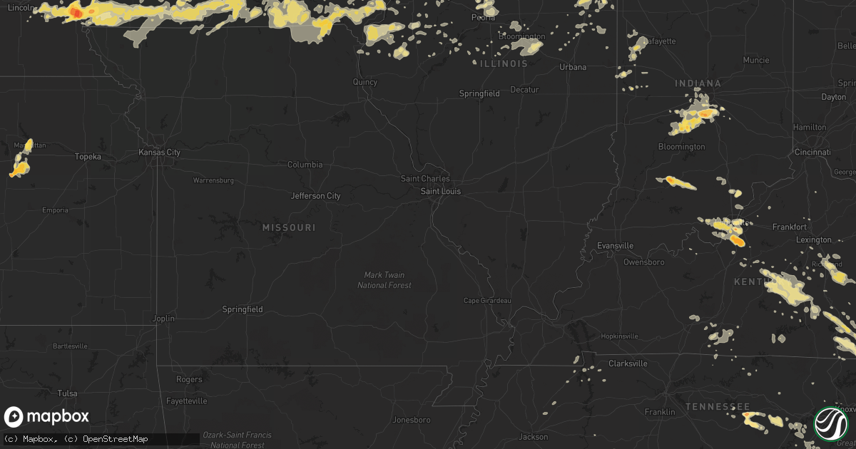
Hail Map in Tennessee on June 19, 2011
Get this storm
June 19 map
$229
one time, instant access
Download today. No call, no setup
Keep the $229
Bought the map and want the full workflow? Apply the entire $229 to a subscription within 7 days. None of it is wasted.
Every map, not just this one
This buys you this map. Subscription and you get every map we run, in the markets you choose from a few cities to whole states to nationwide. Plus real-time alerts the moment a storm fires.
Contact data
Name, contact info, occupancy, even credit band for addresses in the footprint. You go from where it hit to who to call.
Become the source they trust
Unlimited branding weather history reports on demand. You already have the documented answer ready for the property owner, and you are the one who showed up with it.
Property data and RoofTrace estimates
Pull up any address you have got, its value and the exact code rules for that jurisdiction, straight from One Click Code. Then RoofTrace estimates the squares, pitch, and roof value, priced the way you price.
Storm reports in Tennessee
Tennessee
| Date | Description |
|---|---|
| 06/19/20116:25 PM CDT | Dime to quarter sized hail |
| 06/19/20116:04 PM CDT | Baseball size hail was reported in the oak grove community at state highway 174 and pleasant grove road. |
| 06/19/20115:59 PM CDT | A local report indicates 1.00 inch wind near 2 SE WESTMORELAND |
| 06/19/20115:57 PM CDT | Largest hail measured at 2.25 inches |
| 06/19/20115:47 PM CDT | A local report indicates 1.75 inch wind near 5 N WESTMORELAND |
| 06/19/20112:35 PM CDT | A local report indicates 1.00 inch wind near POWELL |
| 06/19/201111:45 AM CDT | A few trees down. |
| 06/19/20114:00 AM CDT | Numerous trees down across the eastern portions of the county. |
| 06/19/20113:30 AM CDT | One tree down on lonesome pine trail. |
| 06/19/20113:30 AM CDT | Trees down on little creek |
| 06/19/20113:20 AM CDT | One tree down |
| 06/19/20113:03 AM CDT | Trees down on highway 25e. |
| 06/19/20112:45 AM CDT | Multiple trees down |
| 06/18/20119:55 PM CDT | Tree down on home. |
| 06/18/20119:55 PM CDT | Tree down on home at 108 mason street. |
| 06/18/20119:40 PM CDT | A local report indicates 1.00 inch wind near 5 SSE MADISONVILLE |
| 06/18/20119:25 PM CDT | One tree down on big spring gap rd. |
| 06/18/20119:05 PM CDT | A local report indicates 1.00 inch wind near TEN MILE |
| 06/18/20119:00 PM CDT | A local report indicates 2.00 inch wind near SPARTA |
| 06/18/20119:00 PM CDT | Golfball size hail reported by public on hodges ferry road. |
| 06/18/20118:50 PM CDT | Few tree limbs down. |
| 06/18/20118:28 PM CDT | 1 inch diameter hail was reported. |
| 06/18/20118:15 PM CDT | Golfball hail reported by public in de rossett in white county. |
| 06/18/20118:00 PM CDT | A local report indicates 1.75 inch wind near CROSSVILLE |
| 06/18/20117:55 PM CDT | A local report indicates 1.25 inch wind near SPARTA |
| 06/18/20117:45 PM CDT | A local report indicates 1.00 inch wind near COOKEVILLE |
| 06/18/20117:45 PM CDT | Partial roof was blown off a building at 265 south jefferson avenue. |
| 06/18/20117:42 PM CDT | Several trees were blown over near the intersection of willow avenue and west cemetery road. |
| 06/18/20117:36 PM CDT | A local report indicates 1.00 inch wind near ALGOOD |
| 06/18/20117:36 PM CDT | A local report indicates 2.00 inch wind near COOKEVILLE |
| 06/18/20117:35 PM CDT | A local report indicates 1.00 inch wind near COOKEVILLE |
| 06/18/20117:35 PM CDT | A local report indicates 60 MPH wind near 3 NE COOKEVILLE |
| 06/18/20117:30 PM CDT | A local report indicates 1.75 inch wind near COOKEVILLE |
| 06/18/20117:30 PM CDT | Several trees and powerlines down in and around algood and northeast of cookeville |
| 06/18/20117:28 PM CDT | A local report indicates 1.00 inch wind near COOKEVILLE |
| 06/18/20117:26 PM CDT | A local report indicates 1.75 inch wind near 5 N COOKEVILLE |
| 06/18/20117:25 PM CDT | A local report indicates 1.25 inch wind near 2 N COOKEVILLE |
| 06/18/20117:14 PM CDT | A local report indicates 1.00 inch wind near GAINESBORO |
| 06/18/20117:04 PM CDT | A local report indicates 1.00 inch wind near GAINESBORO |
All States Impacted by Hail Map on June 19, 2011
Cities Impacted by Hail Map on June 19, 2011
- Palisade, NE
- Hayes Center, NE
- Elwood, NE
- Maywood, NE
- Edison, NE
- Holdrege, NE
- McCook, NE
- Elsie, NE
- Stockville, NE
- Haigler, NE
- Bartley, NE
- Farnam, NE
- Eustis, NE
- Moorefield, NE
- Arapahoe, NE
- Culbertson, NE
- Bertrand, NE
- Wray, CO
- Holbrook, NE
- Indianola, NE
- Wauneta, NE
- Cambridge, NE
- Holyoke, CO
- Champion, NE
- Atlanta, NE
- Parks, NE
- Enders, NE
- Curtis, NE
- Oxford, NE
- Maxwell, NE
- Benkelman, NE
- Imperial, NE
- Seneca, IL
- Morris, IL
- Newark, IL
- Marseilles, IL
- Robbins, TN
- Paxton, IL
- Fremont, IA
- Cedar, IA
- Mount Olive, NC
- Liberty, MO
- Callaway, NE
- Waukee, IA
- Van Meter, IA
- West Des Moines, IA
- Cumming, IA
- Dover, TN
- Buda, IL
- Bradford, IL
- Sheffield, IL
- Neponset, IL
- Stilesville, IN
- Monrovia, IN
- Ashland, NE
- Lacona, IA
- Chariton, IA
- Blair, NE
- Kennard, NE
- Iroquois, IL
- Watseka, IL
- Sheldon, IL
- Sparta, TN
- Doyle, TN
- Kim, CO
- Memphis, MO
- Arbela, MO
- Menlo, IA
- Cedar Island, NC
- Prague, NE
- Cedar Bluffs, NE
- Colon, NE
- Malmo, NE
- Morse Bluff, NE
- Fremont, NC
- Stantonsburg, NC
- Waynesburg, KY
- Gravel Switch, KY
- Kings Mountain, KY
- Springfield, KY
- Middleburg, KY
- Yosemite, KY
- Hustonville, KY
- Eubank, KY
- Bethelridge, KY
- Stanford, KY
- Parksville, KY
- Liberty, KY
- Crab Orchard, KY
- Lebanon, KY
- Elk Horn, KY
- Bradfordsville, KY
- Bean Station, TN
- Yutan, NE
- Valley, NE
- Blakesburg, IA
- Unionville, IA
- Drakesville, IA
- Strasburg, CO
- Bennett, CO
- Wallace, KS
- Sharon Springs, KS
- Science Hill, KY
- Indianapolis, IN
- Elk Horn, IA
- Marne, IA
- Avoca, IA
- Harlan, IA
- Kimballton, IA
- Walnut, IA
- Branson, CO
- Dickens, NE
- Wellfleet, NE
- Albia, IA
- Moravia, IA
- Axtell, NE
- Fairland, IN
- Louisville, KY
- Elizabeth, IN
- Lanesville, IN
- New Albany, IN
- Las Animas, CO
- La Junta, CO
- Murdock, NE
- Rosalie, NE
- Lyons, NE
- Herman, NE
- Arlington, NE
- Covington, IN
- Kingman, IN
- Ordway, CO
- Olney Springs, CO
- Unionville, MO
- Coatsville, MO
- Pulaski, IA
- Livonia, MO
- Udell, IA
- Bloomfield, IA
- Exline, IA
- Moulton, IA
- Centerville, IA
- Keosauqua, IA
- Silver Creek, NE
- Chavies, KY
- Lost Creek, KY
- Eagleville, MO
- Hatfield, MO
- Sparland, IL
- Marquette, NE
- Central City, NE
- Nodaway, IA
- Corning, IA
- Colchester, IL
- Plymouth, IL
- Clarks, NE
- Fullerton, NE
- Woodrow, CO
- Keota, IA
- Spencer, TN
- San Jose, IL
- Emden, IL
- Crook, CO
- Knoxville, IA
- La Moille, IL
- Arlington, IL
- Easley, SC
- Erin, TN
- Vail, IA
- Tazewell, TN
- Sneedville, TN
- Scotia, NE
- Loup City, NE
- Saint Paul, NE
- Elba, NE
- North Loup, NE
- Wolbach, NE
- Ashton, NE
- Edina, MO
- Wyaconda, MO
- Rutledge, MO
- La Belle, MO
- Knox City, MO
- Ithaca, NE
- Florence, SC
- Conway, SC
- Myrtle Beach, SC
- Broken Bow, NE
- Mount Ayr, IA
- Benton, IA
- Diagonal, IA
- Milan, IL
- Sherrard, IL
- Effingham, SC
- Mead, NE
- Wahoo, NE
- Saint Patrick, MO
- Kahoka, MO
- Cheyenne, WY
- Dodge, NE
- Hordville, NE
- Rose Hill, IA
- Delta, IA
- La Harpe, IL
- Dix, NE
- Palmer, NE
- Milan, MO
- Logan, IA
- Persia, IA
- Allerton, IA
- Humeston, IA
- Corydon, IA
- Columbus, NE
- Dallas City, IL
- Snow Hill, NC
- Wapello, IA
- Morning Sun, IA
- Yuma, CO
- Richmond, KY
- Ellston, IA
- Tingley, IA
- Shannon City, IA
- Guernsey, IA
- Sidney, IA
- Cheraw, CO
- Rocky Ford, CO
- London, KY
- Orleans, IN
- Mitchell, IN
- Toulon, IL
- Hamlin, IA
- Exira, IA
- Audubon, IA
- Bourbonnais, IL
- Barnes City, IA
- Montezuma, IA
- New Sharon, IA
- Roggen, CO
- Merna, NE
- Brady, NE
- Gothenburg, NE
- Anselmo, NE
- Arnold, NE
- Grand Ridge, IL
- Ottawa, IL
- Streator, IL
- Des Moines, IA
- Carlisle, IA
- Glasgow, KY
- Lucas, KY
- Scottsville, KY
- Plattsmouth, NE
- Casey, IA
- Dexter, IA
- Stuart, IA
- Rogersville, TN
- Faison, NC
- Mossville, IL
- Chillicothe, IL
- Watkins, CO
- Winona, KS
- Wellman, IA
- Gresham, SC
- Webster, IA
- Sigourney, IA
- Nichols, SC
- Ashkum, IL
- Clifton, IL
- Pikeville, TN
- Cameron, MO
- Fairdale, KY
- Shepherdsville, KY
- Brooks, KY
- Mount Washington, KY
- Gretna, NE
- Bellwood, NE
- Shelby, NE
- Belgrade, NE
- Genoa, NE
- Veedersburg, IN
- Winterset, IA
- Edward, NC
- Blounts Creek, NC
- Aurora, NC
- Pineville, KY
- Williamsburg, KY
- Harrogate, TN
- Calvin, KY
- Barbourville, KY
- Middlesboro, KY
- Rockholds, KY
- Cumberland Gap, TN
- Bryants Store, KY
- Corbin, KY
- Kankakee, IL
- Gravity, IA
- New Market, IA
- Bedford, IA
- Clearfield, IA
- Clarinda, IA
- Sharpsburg, IA
- Mohawk, TN
- Midway, TN
- North Bend, NE
- Towanda, IL
- Junction City, KS
- Dwight, KS
- White City, KS
- Missouri Valley, IA
- Monterey, TN
- Eckley, CO
- Venango, NE
- Henry, IL
- Putnam, IL
- Tiskilwa, IL
- Williams, IN
- Shoals, IN
- Bargersville, IN
- Martinsville, IN
- Morgantown, IN
- Keystone, NE
- Paxton, NE
- Crowley, CO
- Denison, IA
- Manilla, IA
- Swink, CO
- Wiley, CO
- Eads, CO
- McClave, CO
- Tribune, KS
- Hasty, CO
- Sheridan Lake, CO
- Weskan, KS
- Arlington, CO
- Afton, IA
- Johnston, IA
- Farragut, IA
- Riverton, IA
- Shenandoah, IA
- Basco, IL
- Corydon, IN
- New Salisbury, IN
- Ramsey, IN
- Fort Morgan, CO
- Otis, CO
- McKee, KY
- Berea, KY
- Irvine, KY
- Panora, IA
- Plano, IA
- Seymour, IA
- Promise City, IA
- Lafayette, TN
- Wallace, NE
- Pamplico, SC
- Timmonsville, SC
- Oakland, KY
- Smiths Grove, KY
- Bowling Green, KY
- Edelstein, IL
- Dunlap, IL
- Princeville, IL
- Speer, IL
- Wyoming, IL
- Campbellsburg, IN
- Loogootee, IN
- Crane, IN
- Funk, NE
- Bonaparte, IA
- Mount Sterling, IA
- Hillsboro, IA
- Augusta, IL
- Franklin, NC
- Georgetown, KY
- Saint Charles, IA
- North Platte, NE
- Clearmont, MO
- Burlington Junction, MO
- Lillington, NC
- Angier, NC
- Spring City, TN
- Rockwood, TN
- Skidmore, MO
- Clinton, NC
- Turkey, NC
- Magnolia, NC
- Warsaw, NC
- Chula, MO
- Galva, IL
- Kewanee, IL
- Elmwood, NE
- Palmyra, NE
- Eagle, NE
- Piper City, IL
- Reddick, IL
- Danforth, IL
- Buckingham, IL
- Chebanse, IL
- Herscher, IL
- Cabery, IL
- Gilman, IL
- Atkinson, NE
- West Point, NE
- David City, NE
- Fairfax, MO
- Earlham, IA
- Haxtun, CO
- Amherst, CO
- Depauw, IN
- Milltown, IN
- Queen City, MO
- Downing, MO
- Shelton, NE
- Kenesaw, NE
- Thorn Hill, TN
- Mooresburg, TN
- Blandinsville, IL
- Hershey, NE
- Metamora, IL
- East Peoria, IL
- Peoria, IL
- Avoca, NE
- Union, NE
- Randolph, IA
- Imogene, IA
- Thurman, IA
- Nehawka, NE
- Percival, IA
- Otoe, NE
- Hamburg, IA
- Nebraska City, NE
- Greenville, SC
- Carthage, IL
- Greeley, NE
- Quebeck, TN
- Perrysville, IN
- Wood River, NE
- Pleasant Hill, IA
- Ansley, NE
- Westerville, NE
- Bradley, IL
- Westmoreland, TN
- Good Hope, IL
- Bushnell, IL
- Greeneville, TN
- McLean, IL
- Stanford, IL
- Armington, IL
- Ceresco, NE
- Milton, IA
- Douds, IA
- Manhattan, KS
- Omaha, NE
- Truro, IA
- New Virginia, IA
- Gilson, IL
- Dahinda, IL
- Essex, IL
- Bonfield, IL
- Wilmington, IL
- Memphis, NE
- Atlantic, IA
- Mason City, IL
- Forest City, IL
- Easton, IL
- Keenesburg, CO
- Mosheim, TN
- Bulls Gap, TN
- Cozad, NE
- Warne, NC
- Brasstown, NC
- Hayesville, NC
- Murphy, NC
- Cookeville, TN
- Rogers, NE
- Linwood, NE
- Louisville, NE
- Weeping Water, NE
- Kimball, NE
- New Raymer, CO
- Model, CO
- Rock Island, TN
- Marion, SC
- Hollywood, FL
- Eddyville, IA
- Sidney, NE
- Marshall, IN
- Bloomingdale, IN
- Wilson, NC
- Burlington, IA
- West Burlington, IA
- Saint Marys, IA
- Prole, IA
- Griswold, IA
- Princeton, IL
- Bureau, IL
- Wyanet, IL
- Brush, CO
- Akron, CO
- Linden, TN
- Lancaster, KY
- Miracle, KY
- Creston, IA
- Lenox, IA
- Pender, NE
- Junction City, KY
- Franklin, IN
- Greenwood, IN
- Windsor Heights, IA
- Searsboro, IA
- Grinnell, IA
- Springfield, NE
- King City, MO
- Oakville, IA
- Riverside, IA
- Kalona, IA
- Somerset, KY
- Bardstown, KY
- Joy, IL
- New Boston, IL
- Carlock, IL
- Sublette, IL
- Ohio, IL
- Van Orin, IL
- Ewing, VA
- Westside, IA
- Wall Lake, IA
- Breda, IA
- Odebolt, IA
- Hooper, NE
- Comstock, NE
- Walton, NE
- Harrells, NC
- Elizabethtown, NC
- Garland, NC
- Grand Island, NE
- Snyder, CO
- Parnell, IA
- What Cheer, IA
- Brooklyn, IA
- Malcom, IA
- Fremont, NE
- Scribner, NE
- Winslow, NE
- Ames, NE
- Fontanelle, IA
- Leland, IL
- Osceola, NE
- Monroe, NE
- Oakland, NE
- Derby, IA
- Lamoni, IA
- Garden Grove, IA
- Leon, IA
- Russell, IA
- Millerton, IA
- Weldon, IA
- Kellerton, IA
- Grand River, IA
- Decatur, IA
- Van Wert, IA
- Minooka, IL
- Schuyler, NE
- Newport, NC
- Siler, KY
- Frakes, KY
- Speedwell, TN
- New Tazewell, TN
- Morristown, TN
- Whitesburg, TN
- Russellville, TN
- Adair, IA
- Guthrie Center, IA
- Anita, IA
- Wilcox, NE
- Lindsay, NE
- Salem, IA
- Walthill, NE
- Stuart, NE
- Atlanta, IL
- Orleans, NE
- Kearney, NE
- Loomis, NE
- Elm Creek, NE
- Verona, IL
- Murray, IA
- Morehead City, NC
- Orrick, MO
- Masonic Home, KY
- Nauvoo, IL
- Niota, IL
- Hamilton, IL
- Mooresville, IN
- Whiteland, IN
- Sutter, IL
- Washington, IL
- Shelbyville, IN
- Hubert, NC
- Stella, NC
- Maysville, NC
- Crescent City, IL
- Albany, MO
- Young Harris, GA
- Hiawassee, GA
- Iowa City, IA
- Lone Tree, IA
- Hills, IA
- Coralville, IA
- Deep River, IA
- Coxs Creek, KY
- Downs, IL
- Le Roy, IL
- Craig, NE
- Onarga, IL
- Hemingway, SC
- Marshall, NC
- Mars Hill, NC
- Nickerson, NE
- Rising City, NE
- Marysville, IN
- Underwood, IN
- Nabb, IN
- Lexington, IN
- Garner, NC
- Polk City, IA
- Madrid, IA
- Rock Port, MO
- Iliff, CO
- Lemoyne, NE
- Lineville, IA
- Hopkins, MO
- Smithfield, IL
- Ellisville, IL
- Cuba, IL
- Minden, NE
- La Vista, NE
- Boys Town, NE
- Howells, NE
- Stanton, NE
- Clarkson, NE
- Manzanola, CO
- Fowler, CO
- Davis City, IA
- Blythedale, MO
- Pine Village, IN
- West Lafayette, IN
- Westpoint, IN
- Otterbein, IN
- Williamsport, IN
- Attica, IN
- Galesburg, IL
- Woodhull, IL
- New Windsor, IL
- Rio, IL
- Oneida, IL
- Alpha, IL
- North Henderson, IL
- Martinton, IL
- Defiance, IA
- Murray, NE
- Warsaw, IL
- Alexandria, MO
- Jackson, KY
- Rowdy, KY
- Hazard, KY
- Whick, KY
- Wiota, IA
- Boston, KY
- New Haven, KY
- Cainsville, MO
- Hale, MO
- Gray Court, SC
- Enoree, SC
- Redfield, IA
- Linden, IA
- Eminence, KY
- New Castle, KY
- Underwood, IA
- McClelland, IA
- Council Bluffs, IA
- North Liberty, IA
- Belton, SC
- Pelzer, SC
- Paris, TN
- Emerald Isle, NC
- Atlantic Beach, NC
- Salter Path, NC
- Montezuma, IN
- Trinidad, CO
- Lucas, IA
- Montrose, IA
- Tennessee, IL
- Elvaston, IL
- Keokuk, IA
- Macomb, IL
- Gibson, IA
- Gray, KY
- Keavy, KY
- Lily, KY
- Greenfield, IA
- Boelus, NE
- Dannebrog, NE
- Farwell, NE
- Doniphan, NE
- Winchester, KY
- Aledo, IL
- Campton, KY
- Adolphus, KY
- Sutherland, NE
- Thayer, IA
- Julesburg, CO
- Pella, IA
- Lynnville, IA
- Sully, IA
- Monmouth, IL
- Oquawka, IL
- Granville, IL
- Standard, IL
- McNabb, IL
- Wever, IA
- Danville, IA
- West Point, IA
- Kenansville, NC
- Bethpage, TN
- Chatsworth, IL
- Bellevue, NE
- Smithville, TN
- Stockport, IA
- Donnellson, IA
- Farmington, IA
- Monticello, KY
- Alpha, KY
- Grimes, IA
- Urbandale, IA
- Clive, IA
- Granger, IA
- Kirksville, MO
- Clinton, TN
- Powell, TN
- Oxford, IN
- Boswell, IN
- Templeton, IN
- Jamesport, MO
- Crossville, TN
- Mendota, IL
- Roca, NE
- Elkhart, IA
- Tekamah, NE
- West Branch, IA
- Richmond, MO
- Falmouth, KY
- Henryville, IN
- Otisco, IN
- Chillicothe, MO
- La Fayette, IL
- Savannah, MO
- Rea, MO
- Earling, IA
- Tellico Plains, TN
- Avon, SD
- Humphrey, NE
- Stapleton, NE
- Mullins, SC
- Lancaster, MO
- Rossville, IL
- Coal City, IL
- Dover, NC
- Crothersville, IN
- Brownstown, IN
- Duff, TN
- Beulaville, NC
- Sheridan, MO
- Ridgeway, MO
- Harrodsburg, KY
- Birmingham, IA
- Paragon, IN
- Neola, IA
- Green City, MO
- Bryson City, NC
- Annawan, IL
- Atkinson, IL
- Gibbon, NE
- Selma, NC
- Gallatin, MO
- Fort Riley, KS
- Troy Grove, IL
- Danville, IL
- Cayuga, IN
- Georgetown, IL
- Cissna Park, IL
- Kenly, NC
- Lucama, NC
- Maitland, MO
- Mound City, MO
- Peru, IA
- Orient, IA
- Clayton, NC
- Limestone, TN
- Chuckey, TN
- Grandview, TN
- Massena, IA
- Coin, IA
- Northboro, IA
- Ellsworth, IL
- Archer, NE
- Phillips, NE
- Chapman, NE
- Saint Libory, NE
- North English, IA
- South English, IA
- Ogallala, NE
- Canton, IL
- Albany, KY
- Jamestown, KY
- Syracuse, NE
- Essex, IA
- Yorktown, IA
- Unadilla, NE
- Blanchard, IA
- Tabor, IA
- Dunbar, NE
- Miami, FL
- Middletown, IA
- Norwalk, IA
- Indianola, IA
- Danville, KY
- Lostant, IL
- Tonica, IL
- Sterling, CO
- Brooklyn, IN
- Gosport, IN
- Media, IL
- Stronghurst, IL
- Carman, IL
- Beaverville, IL
- Ravenna, NE
- Litchfield, NE
- Hazard, NE
- Manley, NE
- Green Road, KY
- Hinkle, KY
- Girdler, KY
- Kempton, IL
- Shelby, IA
- Portsmouth, IA
- Perry, IA
- Hillsboro, IN
- Waynetown, IN
- Ovid, CO
- Big Springs, NE
- Chappell, NE
- Osceola, IA
- Woodbine, IA
- Papillion, NE
- Sargent, NE
- Crescent, IA
- Altoona, IA
- Runnells, IA
- Mitchellville, IA
- Hopedale, IL
- Needham, IN
- Beech Grove, IN
- Stinesville, IN
- Clayton, IN
- Ellettsville, IN
- West Newton, IN
- Quincy, IN
- Camby, IN
- Plainfield, IN
- Bloomington, IN
- Polk, NE
- Fort Calhoun, NE
- Honey Creek, IA
- Platte Center, NE
- Duncan, NE
- Weston, NE
- Bruno, NE
- Saint Edward, NE
- Cedar Rapids, NE
- Bennington, NE
- Minden, IA
- Panama, IA
- Kirkman, IA
- Stromsburg, NE
- Modale, IA
- Irwin, IA
- Brookfield, MO
- Sumner, MO
- Stamping Ground, KY
- Fountain Run, KY
- Loris, SC
- Astoria, IL
- Niobrara, NE
- Springfield, SD
- Smithfield, NE
- Arcadia, NE
- Ord, NE
- Delavan, IL
- Galt, MO
- Marietta, IL
- Macy, NE
- Richland, IA
- Weldona, CO
- Malden, IL
- West Brooklyn, IL
- Holly Springs, NC
- Fuquay Varina, NC
- Havana, IL
- Union Star, MO
- Helena, MO
- Potter, NE
- Apex, NC
- Naper, NE
- Ware Shoals, SC
- Laurens, SC
- Amity, MO
- Maysville, MO
- Humphreys, MO
- Ankeny, IA
- Williamsburg, IA
- Sciota, IL
- Avon, IL
- Prairie City, IL
- Roseville, IL
- Etowah, TN
- Bogard, MO
- Heidrick, KY
- Artemus, KY
- Hialeah, FL
- Dow City, IA
- Cove City, NC
- New Bern, NC
- Excello, MO
- Cary, NC
- Manhattan, IL
- Manteno, IL
- Fisher, IL
- Foosland, IL
- Newport, NE
- Livingston, TN
- Pattonsburg, MO
- Hillrose, CO
- Novinger, MO
- Greenwood, NE
- South Bend, NE
- Havelock, NC
- Bridgewater, IA
- Tarkio, MO
- Ravenna, KY
- Linneus, MO
- Purdin, MO
- Red Boiling Springs, TN
- East Galesburg, IL
- Knoxville, IL
- New London, IA
- Clarkrange, TN
- Irvington, KY
- Teachey, NC
- Kellogg, IA
- Russell Springs, KY
- Hudson, IL
- Beattyville, KY
- Piedmont, SC
- Summer Shade, KY
- Stoney Fork, KY
- Arjay, KY
- Woodbine, KY
- Bimble, KY
- Fourmile, KY
- Hulen, KY
- Flat Lick, KY
- Rutledge, TN
- Washburn, TN
- Grand Mound, IA
- Delmar, IA
- Saint Augustine, IL
- Webster, KY
- Kidder, MO
- Viola, IL
- Reynolds, IL
- Slater, IA
- Campbellsville, KY
- Odessa, MO
- West Liberty, IA
- Carson, IA
- Maquon, IL
- Valparaiso, NE
- Wallins Creek, KY
- Coldiron, KY
- Padroni, CO
- Pompano Beach, FL
- Green Valley, IL
- Calypso, NC
- Zebulon, NC
- Middlesex, NC
- Sims, NC
- Scottsburg, IN
- Plattsburg, MO
- Trenton, MO
- Wayland, MO
- Rutland, IL
- Hudson, CO
- Walling, TN
- Austin, IN
- Melrose, IA
- Robbinsville, NC
- Bethany, MO
- New Hampton, MO
- Tompkinsville, KY
- Wiggins, CO
- Keswick, IA
- Topeka, IL
- Mount Pleasant, IA
- Mount Union, IA
- Craig, MO
- Avon, IN
- Fairview, IL
- Tina, MO
- Moorhead, IA
- Abie, NE
- Brayton, IA
- Brainard, NE
- Waverly, NE
- Adel, IA
- Woodward, IA
- Minburn, IA
- Cairo, NE
- Dawson, IA
- Bancroft, NE
- Yale, IA
- Booneville, IA
- Sheldahl, IA
- De Soto, IA
- Waterloo, NE
- Dallas Center, IA
- Leigh, NE
- Harris, MO
- Newtown, MO
- Waco, KY
- Hilham, TN
- Pembroke Township, IL
- Donovan, IL
- Saint Anne, IL
- Morocco, IN
- Eureka, IL
- Peoria Heights, IL
- Lowpoint, IL
- Edwards, IL
- Hillsdale, IN
- Shirley, IL
- Heyworth, IL
- Pickering, MO
- Green Castle, MO
- Park City, KY
- Zolfo Springs, FL
- Lorimor, IA
- Osco, IL
- Blockton, IA
- Booneville, KY
- Crestline, OH
- Tiro, OH
- Stanton, IA
- Villisca, IA
- Nicholasville, KY
- Goshen, KY
- Charlestown, IN
- Prospect, KY
- Hamilton, MO
- Fort Madison, IA
- Denmark, IA
- Saint Paul, IA
- New Concord, KY
- Hazel, KY
- Murray, KY
- Cloverdale, IN
- Coatesville, IN
- Annville, KY
- Smithshire, IL
- Latta, SC
- Sellers, SC
- Coats, NC
- Lavinia, TN
- Redding, IA
- Mystic, IA
- Elmo, MO
- Woodburn, IA
- Lincoln, NE
- Malvern, IA
- Shambaugh, IA
- Alvo, NE
- College Springs, IA
- Clio, IA
- Maryville, MO
- Cameron, IL
- Moncure, NC
- Pittsboro, NC
- Wellington, IL
- Hoopeston, IL
- Milford, IL
- Oriental, NC
- Norborne, MO
- Illinois City, IL
- Harper, IA
- Hastings, IA
- Columbia, KY
- Deep Run, NC
- Pink Hill, NC
- Hedrick, IA
- Williamston, SC
- Anderson, SC
- Cantril, IA
- Oliver Springs, TN
- Mount Vernon, KY
- Kingsley, IA
- Bennet, NE
- Cumberland, IA
- Danville, IN
- Sweetwater, TN
- Niota, TN
- Athens, TN
- Depew, OK
- Boggstown, IN
- Fredericksburg, IA
- Sumner, IA
- Gibson City, IL
- Mediapolis, IA
- Earlville, IL
- Paw Paw, IL
- Lynn Center, IL
- Johnsonville, SC
- Lewistown, IL
- Mount Hermon, KY
- Hurdland, MO
- Dunnville, KY
- Bybee, TN
- Frankfort, IL
- Braidwood, IL
- Braceville, IL
- Alexis, IL
- La Plata, MO
- Elmer, MO
- Crestwood, KY
- Plainfield, IL
- Oakland, IA
- Stewart, TN
- Kinston, NC
- Loda, IL
- Alta Vista, KS
- Englewood, TN
- Madisonville, TN
- Leonore, IL
- Oglesby, IL
- Floyds Knobs, IN
- Glenview, KY
- Crandall, IN
- Jeffersonville, IN
- Georgetown, IN
- Gladstone, IL
- Biggsville, IL
- Sperry, IA
- Cincinnati, IA
- Yarmouth, IA
- Floris, IA
- Luray, MO
- Ottumwa, IA
- Decatur, TN
- Ten Mile, TN
- Bolivia, NC
- Abbeville, SC
- Willow Spring, NC
- Raleigh, NC
- Spring Valley, IL
- Nancy, KY
- Big Sandy, TN
- Kingston, TN
- Merritt, NC
- Keithsburg, IL
- Seaton, IL
- Gibbs, MO
- Sandgap, KY
- Wilmore, KY
- Cambridge, IL
- Altona, IL
- Albertson, NC
- Topton, NC
- Barnard, MO
- Guilford, MO
- Fort Pierce, FL
- Hartsburg, IL
- Libertyville, IA
- Fairfield, IA
- Lexington, NE
- Trenton, NE
- Vancleve, KY
- Offutt Afb, NE
- Smithfield, NC
- Hampton, NE
- Fort Lauderdale, FL
- Georgetown, SC
- Vincent, KY
- Fisherville, KY
- Moss, TN
- Orion, IL
- Austin, KY
- Eighty Eight, KY
- Etoile, KY
- Mackinaw, IL
- Danvers, IL
- Emington, IL
- McFall, MO
- Normal, IL
- Bloomington, IL
- Edmonton, KY
- Herington, KS
- Pine Level, NC
- Four Oaks, NC
- Lexington, KY
- Deer Creek, IL
- Pacific Junction, IA
- Oskaloosa, IA
- Leighton, IA
- Bowen, IL
- Bristow, OK
- Sibley, IL
- Mineral, IL
- Atalissa, IA
- Roseboro, NC
- Autryville, NC
- Dudley, NC
- Philadelphia, TN
- Longs, SC
- North Myrtle Beach, SC
- Afton, TN
- Hohenwald, TN
- Buckley, IL
- Roberts, IL
- Waveland, IN
- Dwight, IL
- Perryville, KY
- Geneseo, IL
- Whitleyville, TN
- Weatherby, MO
- Creston, NE
- Liverpool, IL
- Macksburg, IA
- Rose Hill, NC
- Byers, CO
- Fork, SC
- Martinsville, MO
- Gorin, MO
- Baring, MO
- Lebanon Junction, KY
- Buchanan, TN
- Nevada, IA
- Cambridge, IA
- Paint Lick, KY
- Coral Springs, FL
- Anchor, IL
- Huntingdon, TN
- Melcher Dallas, IA
- Farmer City, IL
- Wapella, IL
- Jameson, MO


