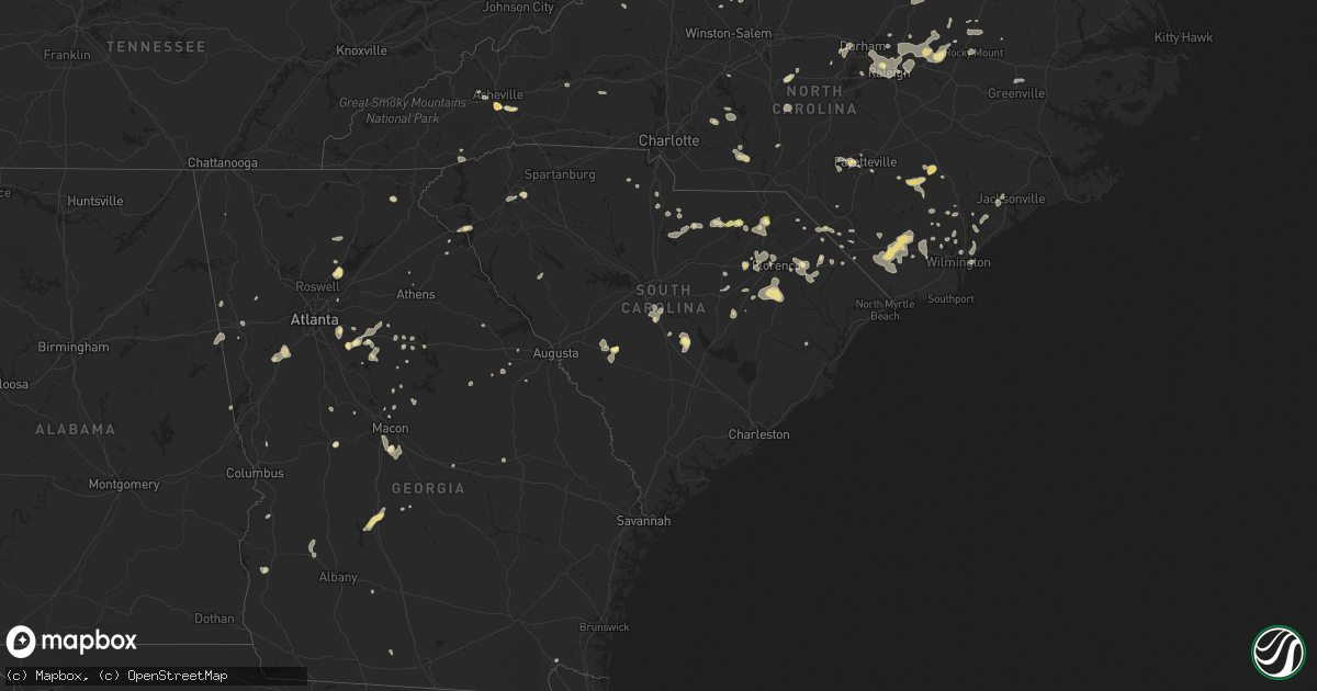
Hail Map in South Carolina on June 18, 2015
Get this storm
June 18 map
$229
one time, instant access
Download today. No call, no setup
Keep the $229
Bought the map and want the full workflow? Apply the entire $229 to a subscription within 7 days. None of it is wasted.
Every map, not just this one
This buys you this map. Subscription and you get every map we run, in the markets you choose from a few cities to whole states to nationwide. Plus real-time alerts the moment a storm fires.
Contact data
Name, contact info, occupancy, even credit band for addresses in the footprint. You go from where it hit to who to call.
Become the source they trust
Unlimited branding weather history reports on demand. You already have the documented answer ready for the property owner, and you are the one who showed up with it.
Property data and RoofTrace estimates
Pull up any address you have got, its value and the exact code rules for that jurisdiction, straight from One Click Code. Then RoofTrace estimates the squares, pitch, and roof value, priced the way you price.
Storm reports in South Carolina
South Carolina
| Date | Description |
|---|---|
| 06/18/20156:50 PM CDT | Two small trees blown down just off highway 223 near edgemoor. |
| 06/18/20156:50 PM CDT | Tree down on roadway at winter road and hall spencer road. Another tree down along saluda road which is west of interstate 77. |
| 06/18/20156:43 PM CDT | Portman marina had brief quarter sized hail and strong wind. Wind was not strong enough to cause damage in their immediate area. |
| 06/18/20155:55 PM CDT | Trees down on houses and cars. |
| 06/18/20155:55 PM CDT | A local report indicates 60 MPH wind near FORT LAWN |
| 06/18/20155:30 PM CDT | Numerous trees down. |
| 06/18/20155:28 PM CDT | Multiple trees down on chantilly rue court between five forks and simpsonville. |
| 06/18/20155:25 PM CDT | Power lines down in roadway at intersection of holland road and bridges road. Part of a tree blown down in five forks area. Tree in roadway at intersection of augusta r |
| 06/18/20154:38 PM CDT | Trees down. A tree in the road at intersection of galilee road and rock house road...tree in the road along scotch cross road...a tree on highway 34. |
| 06/18/20154:30 PM CDT | Tree down next to hwy 52. |
| 06/18/20154:18 PM CDT | 8 trees down in roadway in front of creek bridge high school. Local em also reports numerous trees down across city of marion. Time estimated by radar. |
| 06/18/20154:10 PM CDT | Tree on roadway |
| 06/18/20154:10 PM CDT | Tree down |
| 06/18/20153:42 PM CDT | Sc hwy patrol reported power lines on state hwy 6 near hwy 267 |
| 06/18/20153:42 PM CDT | Law enforcement reported trees down at 620 hampton street near elloree. |
| 06/18/20153:29 PM CDT | Highway patrol reported one tree down on sc 261 near wateree prison. |
| 06/18/20153:25 PM CDT | Public reported large branches and trees down between elloree and cameron. |
| 06/18/20153:25 PM CDT | Trees and powerlines down just northeast of alcolu. |
| 06/18/20153:25 PM CDT | Multiple trees and power poles-lines down in lonestar |
| 06/18/20153:15 PM CDT | Multiple trees and power poles-lines down in cameron |
| 06/18/20153:15 PM CDT | Trees downed in roadway. |
| 06/18/20153:11 PM CDT | Law enforcement reported a couple of trees and powerlines down on st.charles rd south of bishopville. |
| 06/18/20153:08 PM CDT | Report of tree down at rogers convenience store on oakland rd. Time estimated by radar. |
| 06/18/20153:06 PM CDT | Highway patrol reported trees down at universal drive and garners ferry. |
| 06/18/20153:03 PM CDT | Report of tree in roadway at intersection of hill creek rd and sproud rd. Time of event estimated by radar. |
| 06/18/20152:50 PM CDT | Reports of 4 to 5 trees down in and around the city of darlington. Time estimated by radar and call times into 911 center. |
| 06/18/20152:48 PM CDT | Sheriff reported trees down near sandy run including valley ridge rd. |
| 06/18/20152:39 PM CDT | Report of tree down on sc 83 and laurin wilis rd. Time estimated by radar. |
| 06/18/20152:35 PM CDT | Report of tree down at intersection of drew st and society st. Time estimated by radar. |
| 06/18/20152:31 PM CDT | Report of tree down on us 15. |
| 06/18/20152:21 PM CDT | Trees downed in roadway; airport road at jefferson road. Time est from radar. |
| 06/18/20152:19 PM CDT | Nickel to quarter size hail on camp coker rd at hwy 52. |
| 06/18/20152:09 PM CDT | Williston city police had multiple reports of trees and powerlines down including janet street. Also reported dime size hail. |
| 06/18/20152:05 PM CDT | Dot reported trees down on jones road. |
| 06/18/20152:00 PM CDT | Metal roof blown off/structural damage to greenhouse. |
| 06/18/20151:25 PM CDT | Aiken power coop reported power lines down on surrey race rd. |
| 06/18/20151:16 PM CDT | Public reported quarter sized hail on highway 4. |
All States Impacted by Hail Map on June 18, 2015
Cities Impacted by Hail Map on June 18, 2015
- Petersburg, TX
- Falmouth, KY
- Foster, KY
- Middlesex, NC
- Spring Hope, NC
- Clermont, FL
- Lubbock, TX
- Levelland, TX
- Ropesville, TX
- Meadow, TX
- Mosquero, NM
- Suwanee, GA
- Cumming, GA
- Alpharetta, GA
- Arthur, IL
- Greenfield, IN
- Lebanon, TN
- Hartsville, TN
- Ranburne, AL
- Hale Center, TX
- Plainview, TX
- Roswell, NM
- Cameron, SC
- Alcolu, SC
- Killeen, TX
- Fort Hood, TX
- Saint Albans, WV
- Hurricane, WV
- Hallsboro, NC
- Forsyth, GA
- Marion, SC
- Stanley, ND
- Lamar, SC
- Eustis, FL
- Kershaw, SC
- Miami, TX
- Whiteland, IN
- Arden, NC
- Asheville, NC
- Conyers, GA
- Mcdonough, GA
- Covington, GA
- Adrian, TX
- Slaton, TX
- New Paris, OH
- Eldorado, OH
- Eaton, OH
- Greenville, SC
- Mauldin, SC
- Simpsonville, SC
- Jefferson, SC
- McBee, SC
- Bethune, SC
- Lamar, CO
- Decker, MT
- Higgins, TX
- Rocky Mount, NC
- Mullins, SC
- Townville, SC
- Rolla, KS
- Herndon, VA
- Fairfax, VA
- Sumter, SC
- Mayesville, SC
- Dunnellon, FL
- Dalhart, TX
- Bard, NM
- Society Hill, SC
- Cheraw, SC
- Sturgis, SD
- Whitewood, SD
- Fort Meade, SD
- Oakton, VA
- Chantilly, VA
- Maple Hill, NC
- Cobbs Creek, VA
- Hartfield, VA
- Hardyville, VA
- Seale, AL
- Andrews, TX
- Wheatland, WY
- Angola, IN
- Lagrange, IN
- Howe, IN
- Fort Garland, CO
- Raeford, NC
- Fayetteville, NC
- Atkinson, NC
- Marion, VA
- Raleigh, NC
- Centreville, VA
- Annandale, VA
- Sterling, VA
- Springfield, VA
- Burke, VA
- Clifton, VA
- Reston, VA
- Uniontown, OH
- Akron, OH
- Damascus, MD
- Germantown, MD
- Gaithersburg, MD
- Newport, TN
- Bybee, TN
- White Pine, TN
- Absarokee, MT
- Bowie, MD
- Upper Marlboro, MD
- Machipongo, VA
- Franktown, VA
- Exmore, VA
- Nassawadox, VA
- Birdsnest, VA
- Warsaw, VA
- Champlain, VA
- Birney, MT
- Leicester, NC
- Whiteville, NC
- Council, NC
- Lake Waccamaw, NC
- Clarkton, NC
- Roanoke, AL
- Lafayette, AL
- Vienna, VA
- Forest, VA
- Lowry, VA
- Natural Bridge Station, VA
- Goode, VA
- Bedford, VA
- Robbins, NC
- Seagrove, NC
- Junction, TX
- Perryton, TX
- Plains, TX
- Kenbridge, VA
- Idalou, TX
- Lorenzo, TX
- Louisburg, NC
- Zebulon, NC
- Bunn, NC
- Bosler, WY
- Buckhead, GA
- Greensboro, GA
- Fredericksburg, TX
- Fair Play, SC
- Hartley, TX
- Loudon, TN
- Vega, TX
- Bruceton Mills, WV
- Albright, WV
- Ramseur, NC
- Asheboro, NC
- Franklinville, NC
- Danville, IL
- Perrysville, IN
- Georgetown, IL
- Scranton, SC
- Coward, SC
- Madison, GA
- Deland, FL
- Mount Pleasant, NC
- Brandon, FL
- Riverview, FL
- Tampa, FL
- Paisley, FL
- Altoona, FL
- Richmond, IN
- Brooksville, KY
- Mount Olivet, KY
- Fletcher, NC
- Gerton, NC
- Fairview, NC
- Florissant, CO
- Currie, NC
- Wyola, MT
- Lodge Grass, MT
- Otter, MT
- Busby, MT
- Heflin, AL
- Muscadine, AL
- Doss, TX
- Lehigh Acres, FL
- Dawson, GA
- Canon City, CO
- Chapel Hill, NC
- Hyattsville, MD
- Andrews, SC
- Elloree, SC
- Church Creek, MD
- Fishing Creek, MD
- Heath Springs, SC
- Waldorf, MD
- Morgantown, KY
- Rochester, KY
- Berry, KY
- Cynthiana, KY
- Kempner, TX
- Copperas Cove, TX
- Dickerson, MD
- Ijamsville, MD
- Frederick, MD
- Clarksburg, MD
- Springfield, SC
- Williston, SC
- Lick Creek, KY
- Big Rock, VA
- Mouthcard, KY
- Grundy, VA
- Pilgrims Knob, VA
- Oakwood, VA
- Raven, VA
- Leland, NC
- Wagener, SC
- Windsor, SC
- Aiken, SC
- Interlachen, FL
- Florahome, FL
- Palatka, FL
- Keystone Heights, FL
- Clarkesville, GA
- Boston, IN
- Liberty, IN
- Elida, NM
- Glenelg, MD
- Woodbine, MD
- Glenwood, MD
- Coleman, GA
- Franklin, IN
- Bargersville, IN
- Adamstown, MD
- Monroe, VA
- Walnut Cove, NC
- Lanett, AL
- Clinton, NC
- Garland, NC
- Moneta, VA
- San Jon, NM
- Bethel, NC
- Greenville, NC
- Robersonville, NC
- Stokes, NC
- Louisville, CO
- Broomfield, CO
- South Boston, VA
- Carrboro, NC
- Belle Fourche, SD
- Burgaw, NC
- Monticello, GA
- Crossville, TN
- Canadian, TX
- Mobeetie, TX
- Nicholson, GA
- Commerce, GA
- Mansfield, GA
- Lake Butler, FL
- Brooker, FL
- Wildorado, TX
- Social Circle, GA
- Dry Ridge, KY
- Philadelphia, TN
- Warsaw, NC
- Jackson, KY
- Salyersville, KY
- Rousseau, KY
- Turkey, NC
- Harrodsburg, KY
- Gray, GA
- Cincinnati, OH
- Edgemoor, SC
- Portales, NM
- Floyd, NM
- Florence, CO
- Connelly Springs, NC
- Vale, NC
- Five Points, AL
- Lithonia, GA
- Appomattox, VA
- Gladstone, VA
- Sunray, TX
- Dumas, TX
- Cactus, TX
- Fairland, IN
- New Palestine, IN
- Fountaintown, IN
- Indianapolis, IN
- Bremen, GA
- Mason, TX
- Abernathy, TX
- Phyllis, KY
- Simon, WV
- Verner, WV
- Adrian, GA
- Clarendon, NC
- Chadbourn, NC
- Bolton, NC
- Nakina, NC
- Riegelwood, NC
- Olanta, SC
- Timmonsville, SC
- Lake City, SC
- Lafayette, CO
- Sparta, TN
- Cookeville, TN
- Silver Spring, MD
- Olney, MD
- Derwood, MD
- Rockville, MD
- Enfield, NC
- Fort Washington, MD
- Clinton, MD
- Brandywine, MD
- Accokeek, MD
- Owenton, KY
- Wheeler, TX
- La Grange, KY
- Goshen, KY
- Monterey, TN
- Brooksville, FL
- Spring Hill, FL
- Warner Robins, GA
- Macon, GA
- Sundance, WY
- Loveland, OH
- Hartsville, SC
- Patrick, SC
- Lakemore, OH
- Newnan, GA
- Port Clinton, OH
- Lacarne, OH
- Clear Fork, WV
- Balko, OK
- Tahoka, TX
- Crosbyton, TX
- Columbus, MT
- Marion, OH
- Prospect, OH
- Wadesboro, NC
- Norwood, NC
- Autryville, NC
- Roseboro, NC
- Orrum, NC
- Deltaville, VA
- Topping, VA
- Wake, VA
- Weems, VA
- Salem, OH
- Deputy, IN
- Lexington, IN
- Austin, IN
- Scottsburg, IN
- Candler, NC
- Dillon, SC
- Tallapoosa, GA
- Buchanan, GA
- Ararat, VA
- Castalia, NC
- Lake Panasoffkee, FL
- Vancleve, KY
- Bays, KY
- Gunlock, KY
- Billings, MT
- Alzada, MT
- Broadus, MT
- Gatesville, TX
- Lewisburg, OH
- New London, NC
- Richfield, NC
- Mechanicsville, MD
- Aquasco, MD
- Hughesville, MD
- Charlotte Hall, MD
- Suitland, MD
- District Heights, MD
- Lilburn, GA
- Norcross, GA
- Knightdale, NC
- Ransom Canyon, TX
- Vickery, OH
- Fremont, OH
- Ralls, TX
- Dandridge, TN
- Wrightsville Beach, NC
- Wilmington, NC
- Saint Xavier, MT
- Sylvester, GA
- Creedmoor, NC
- Ellerbe, NC
- Candor, NC
- Beloit, OH
- Lovington, IL
- Richburg, SC
- Jacksonville, NC
- Dearing, GA
- Bronwood, GA
- Nye, MT
- Knoxville, TN
- Farnham, VA
- Lancaster, VA
- Tappahannock, VA
- Dawsonville, GA
- Rutledge, GA
- McLeod, MT
- Beechmont, KY
- Drakesboro, KY
- Beaver Dam, KY
- Browder, KY
- Belton, KY
- Kress, TX
- Roberta, GA
- Staley, NC
- Polkton, NC
- Ansonville, NC
- Florence, SC
- Concord, VA
- Madison Heights, VA
- Amherst, VA
- Gaston, SC
- Swansea, SC
- Hendersonville, NC
- Seffner, FL
- Harrells, NC
- Rose Hill, NC
- Weston, WY
- Sonora, TX
- Prince Frederick, MD
- Benedict, MD
- Bowersville, GA
- Darlington, SC
- Wake Forest, NC
- Knightstown, IN
- Carthage, IN
- Lewisville, IN
- Rocky Point, NC
- Fort Branch, IN
- Nebo, NC
- Morganton, NC
- Wolfforth, TX
- Jackson, GA
- Springfield, CO
- Labelle, FL
- Jetson, KY
- Oxford, GA
- Jonesville, KY
- New Liberty, KY
- Durham, NC
- Friona, TX
- Cordele, GA
- Unadilla, GA
- Vienna, GA
- Pinehurst, GA
- Centerville, IN
- Hartwell, GA
- Lynch Station, VA
- Ashburn, VA
- Franklin, KY
- Bowling Green, KY
- Radnor, OH
- Richwood, OH
- Steele, KY
- Elkhorn City, KY
- Regina, KY
- Belcher, KY
- Palmetto, GA
- Sharpsburg, GA
- Fishtail, MT
- Lancaster, SC
- Hulett, WY
- Bowdon, GA
- Punta Gorda, FL
- Arvada, WY
- Swords Creek, VA
- Wilmore, KY
- Folkston, GA
- Rushville, IN
- Spiceland, IN
- Hope, MI
- Rhodes, MI
- Beaverton, MI
- Mayhill, NM
- Bishopville, SC
- Scottsville, KY
- Mitchell, GA
- Warthen, GA
- Sparta, GA
- Valrico, FL
- Willard, NC
- Matthews, GA
- Llano, TX
- Sweetwater, OK
- Aldie, VA
- Leesburg, VA
- Falls Church, VA
- Alexandria, VA
- Arlington, VA
- Dunn Loring, VA
- Albemarle, NC
- Corinth, KY
- Raccoon, KY
- Pikeville, KY
- Live Oak, FL
- Dublin, GA
- Barnesville, GA
- The Rock, GA
- Ellicott City, MD
- Dayton, MD
- West Friendship, MD
- Arcadia, FL
- Rowland, NC
- Glencoe, KY
- Rowe, VA
- Sevierville, TN
- Eatonton, GA
- Logansport, IN
- Royal Center, IN
- Lockney, TX
- Nashville, NC
- Huddleston, VA
- Mason, OH
- West Chester, OH
- Rockville, IN
- Dadeville, AL
- Scotland Neck, NC
- Gresham, SC
- Dallas, GA
- Beltsville, MD
- College Park, MD
- Livingston, TN
- Stockbridge, GA
- Westcliffe, CO
- Morristown, TN
- Saint Matthews, SC
- Orangeburg, SC
- Floydada, TX
- Greenbush, VA
- Onancock, VA
- Accomac, VA
- Fairmont, NC
- Potomac, MD
- Garrett Park, MD
- Kensington, MD
- Bethesda, MD
- Louisville, KY
- Rolesville, NC
- Youngsville, NC
- Hamer, SC
- Ivanhoe, NC
- Keyes, OK
- Gibson, GA
- Hardy, VA
- Ellenwood, GA
- Goodwell, OK
- King, NC
- Cary, NC
- Morrisville, NC
- Clio, SC
- Effingham, SC
- Turbeville, SC
- Sebring, OH
- North Benton, OH
- Cotopaxi, CO
- Erick, OK
- Brevard, NC
- Whitakers, NC
- Ocala, FL
- Hudson, FL
- Groveland, FL
- Montross, VA
- Lenoir City, TN
- Greenwood, SC
- Ozona, TX
- Spearfish, SD
- Wendell, NC
- Pittsboro, NC
- Liberty Hill, SC
- Camden, SC
- Waynesboro, PA
- Fairfield, PA
- Blue Ridge Summit, PA
- Hampstead, NC
- Saint Leonard, MD
- Jefferson, NC
- Buckeystown, MD
- Jefferson, MD
- Monrovia, MD
- Mount Airy, MD
- Middletown, MD
- Piedmont, SC
- Canon, GA
- Royston, GA
- Cerro Gordo, NC
- Fair Bluff, NC
- Rockwood, TN
- Oakdale, TN
- Nichols, SC
- Quitman, GA
- Pavo, GA
- Alva, FL
- Mogadore, OH
- Barberton, OH
- Washington, GA
- Athens, GA
- Centerville, GA
- Byron, GA
- Falmouth, IN
- Straughn, IN
- Pembroke, NC
- Hallieford, VA
- Irvington, VA
- White Stone, VA
- Chesapeake Beach, MD
- Huntingtown, MD
- Castle Hayne, NC
- Hillsboro, GA
- Jacksonville, FL
- Golden, CO
- Arvada, CO
- Poolesville, MD
- York, SC
- Battletown, KY
- Leavenworth, IN
- Hawthorne, FL
- Moorcroft, WY
- McConnells, SC
- Rock Hill, SC
- Martin, KY
- David, KY
- Prestonsburg, KY
- Portland, TN
- Woodburn, KY
- Waldo, FL
- New Zion, SC
- New Market, TN
- Jefferson City, TN
- Beulah, CO
- Brentwood, MD
- Takoma Park, MD
- Mount Rainier, MD
- Washington, DC
- Chevy Chase, MD
- Henderson, NC
- Salem, IN
- Clayton, NM
- Phenix City, AL
- Haddock, GA
- Milledgeville, GA
- Pineview, GA
- Waterford, VA
- Paeonian Springs, VA
- Hamilton, VA
- Felt, OK
- Lake Toxaway, NC
- Lumpkin, GA
- Greenwood, IN
- Hawkinsville, GA
- Clarksville, MD
- Brookeville, MD
- Warrenton, GA
- Stapleton, GA
- Hamilton, GA
- Cataula, GA
- Appling, GA
- Harlem, GA
- Oglesby, TX
- Kelly, NC
- Delco, NC
- Lynchburg, SC
- Reynolds, GA
- Butler, GA
- Lexington, NC
- Fork, SC
- Carrollton, GA
- Dover, FL
- Thonotosassa, FL
- Boyds, MD
- Hawesville, KY
- Franklinton, NC
- Millers Creek, NC
- La Fayette, GA
- Apex, NC
- Tulia, TX
- Astor, FL


