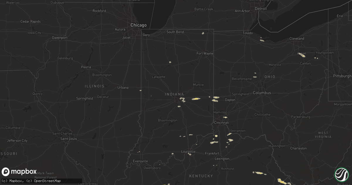
Hail Map in Indiana on June 18, 2015
Get this storm
June 18 map
$229
one time, instant access
Download today. No call, no setup
Keep the $229
Bought the map and want the full workflow? Apply the entire $229 to a subscription within 7 days. None of it is wasted.
Every map, not just this one
This buys you this map. Subscription and you get every map we run, in the markets you choose from a few cities to whole states to nationwide. Plus real-time alerts the moment a storm fires.
Contact data
Name, contact info, occupancy, even credit band for addresses in the footprint. You go from where it hit to who to call.
Become the source they trust
Unlimited branding weather history reports on demand. You already have the documented answer ready for the property owner, and you are the one who showed up with it.
Property data and RoofTrace estimates
Pull up any address you have got, its value and the exact code rules for that jurisdiction, straight from One Click Code. Then RoofTrace estimates the squares, pitch, and roof value, priced the way you price.
Storm reports in Indiana
Indiana
| Date | Description |
|---|---|
| 06/18/20155:49 PM CDT | Tree down at vancampen road and highway 31. Time estimated from radar. |
| 06/18/20154:46 PM CDT | 55 to 60 mph wind gusts. Also some 3 inch diamter tree limbs down about 10 feet long. |
| 06/18/20154:40 PM CDT | 40 ft tall pine tree uprooted...blocking road and hit power lines. |
| 06/18/20154:32 PM CDT | Tree down across cr 400 e half mile south of cr 500 s. |
| 06/18/20154:29 PM CDT | Possible downed utility pole |
| 06/18/20154:25 PM CDT | Cr 200 s at us 33. Large tree limb down |
| 06/18/20153:59 PM CDT | Several trees and power lines down... Some 8 to 12 inches in diameter. |
| 06/18/20153:50 PM CDT | Trees down relayed from fire department |
| 06/18/20153:32 PM CDT | Tree down along sr 56 in eastern part of the county. Time estimated based on radar. |
| 06/18/20153:30 PM CDT | Large tree limb snapped. |
| 06/18/20153:26 PM CDT | Large limbs and trees knocked down along wernie road. Time estimated from radar. |
| 06/18/20153:26 PM CDT | Tree knocked over and power pole damaged. Time estimated from radar. |
| 06/18/20153:26 PM CDT | Large tree uprooted. Time estimated from radar. |
| 06/18/20153:26 PM CDT | Large tree uprooted. Time estimated from radar. |
| 06/18/20153:20 PM CDT | Trees down at black road and thomas hill road. |
| 06/18/20153:18 PM CDT | Numerous full sized trees and power lines down in and around richmond. |
| 06/18/20153:13 PM CDT | 49mph wind gust... Tree down. |
| 06/18/20153:05 PM CDT | Tree down in northwest part of the county along polk rd. Time estimated based on radar. |
| 06/18/20153:04 PM CDT | Tree down near the intersection of route 3 and route 256. Time estimated from radar |
| 06/18/20152:39 PM CDT | Relayed via broadcast media. Shingle damage from roof near speed... In |
| 06/18/20152:05 PM CDT | Large tree limbs down from fairly healthy tree. |
| 06/18/20151:35 PM CDT | Multiple power poles down at sr 236 and 500 n. Police and fire are responding. The wind and rain were strong but no speed reported. |
All States Impacted by Hail Map on June 18, 2015
Cities Impacted by Hail Map on June 18, 2015
- Petersburg, TX
- Falmouth, KY
- Foster, KY
- Middlesex, NC
- Spring Hope, NC
- Clermont, FL
- Lubbock, TX
- Levelland, TX
- Ropesville, TX
- Meadow, TX
- Mosquero, NM
- Suwanee, GA
- Cumming, GA
- Alpharetta, GA
- Arthur, IL
- Greenfield, IN
- Lebanon, TN
- Hartsville, TN
- Ranburne, AL
- Hale Center, TX
- Plainview, TX
- Roswell, NM
- Cameron, SC
- Alcolu, SC
- Killeen, TX
- Fort Hood, TX
- Saint Albans, WV
- Hurricane, WV
- Hallsboro, NC
- Forsyth, GA
- Marion, SC
- Stanley, ND
- Lamar, SC
- Eustis, FL
- Kershaw, SC
- Miami, TX
- Whiteland, IN
- Arden, NC
- Asheville, NC
- Conyers, GA
- Mcdonough, GA
- Covington, GA
- Adrian, TX
- Slaton, TX
- New Paris, OH
- Eldorado, OH
- Eaton, OH
- Greenville, SC
- Mauldin, SC
- Simpsonville, SC
- Jefferson, SC
- McBee, SC
- Bethune, SC
- Lamar, CO
- Decker, MT
- Higgins, TX
- Rocky Mount, NC
- Mullins, SC
- Townville, SC
- Rolla, KS
- Herndon, VA
- Fairfax, VA
- Sumter, SC
- Mayesville, SC
- Dunnellon, FL
- Dalhart, TX
- Bard, NM
- Society Hill, SC
- Cheraw, SC
- Sturgis, SD
- Whitewood, SD
- Fort Meade, SD
- Oakton, VA
- Chantilly, VA
- Maple Hill, NC
- Cobbs Creek, VA
- Hartfield, VA
- Hardyville, VA
- Seale, AL
- Andrews, TX
- Wheatland, WY
- Angola, IN
- Lagrange, IN
- Howe, IN
- Fort Garland, CO
- Raeford, NC
- Fayetteville, NC
- Atkinson, NC
- Marion, VA
- Raleigh, NC
- Centreville, VA
- Annandale, VA
- Sterling, VA
- Springfield, VA
- Burke, VA
- Clifton, VA
- Reston, VA
- Uniontown, OH
- Akron, OH
- Damascus, MD
- Germantown, MD
- Gaithersburg, MD
- Newport, TN
- Bybee, TN
- White Pine, TN
- Absarokee, MT
- Bowie, MD
- Upper Marlboro, MD
- Machipongo, VA
- Franktown, VA
- Exmore, VA
- Nassawadox, VA
- Birdsnest, VA
- Warsaw, VA
- Champlain, VA
- Birney, MT
- Leicester, NC
- Whiteville, NC
- Council, NC
- Lake Waccamaw, NC
- Clarkton, NC
- Roanoke, AL
- Lafayette, AL
- Vienna, VA
- Forest, VA
- Lowry, VA
- Natural Bridge Station, VA
- Goode, VA
- Bedford, VA
- Robbins, NC
- Seagrove, NC
- Junction, TX
- Perryton, TX
- Plains, TX
- Kenbridge, VA
- Idalou, TX
- Lorenzo, TX
- Louisburg, NC
- Zebulon, NC
- Bunn, NC
- Bosler, WY
- Buckhead, GA
- Greensboro, GA
- Fredericksburg, TX
- Fair Play, SC
- Hartley, TX
- Loudon, TN
- Vega, TX
- Bruceton Mills, WV
- Albright, WV
- Ramseur, NC
- Asheboro, NC
- Franklinville, NC
- Danville, IL
- Perrysville, IN
- Georgetown, IL
- Scranton, SC
- Coward, SC
- Madison, GA
- Deland, FL
- Mount Pleasant, NC
- Brandon, FL
- Riverview, FL
- Tampa, FL
- Paisley, FL
- Altoona, FL
- Richmond, IN
- Brooksville, KY
- Mount Olivet, KY
- Fletcher, NC
- Gerton, NC
- Fairview, NC
- Florissant, CO
- Currie, NC
- Wyola, MT
- Lodge Grass, MT
- Otter, MT
- Busby, MT
- Heflin, AL
- Muscadine, AL
- Doss, TX
- Lehigh Acres, FL
- Dawson, GA
- Canon City, CO
- Chapel Hill, NC
- Hyattsville, MD
- Andrews, SC
- Elloree, SC
- Church Creek, MD
- Fishing Creek, MD
- Heath Springs, SC
- Waldorf, MD
- Morgantown, KY
- Rochester, KY
- Berry, KY
- Cynthiana, KY
- Kempner, TX
- Copperas Cove, TX
- Dickerson, MD
- Ijamsville, MD
- Frederick, MD
- Clarksburg, MD
- Springfield, SC
- Williston, SC
- Lick Creek, KY
- Big Rock, VA
- Mouthcard, KY
- Grundy, VA
- Pilgrims Knob, VA
- Oakwood, VA
- Raven, VA
- Leland, NC
- Wagener, SC
- Windsor, SC
- Aiken, SC
- Interlachen, FL
- Florahome, FL
- Palatka, FL
- Keystone Heights, FL
- Clarkesville, GA
- Boston, IN
- Liberty, IN
- Elida, NM
- Glenelg, MD
- Woodbine, MD
- Glenwood, MD
- Coleman, GA
- Franklin, IN
- Bargersville, IN
- Adamstown, MD
- Monroe, VA
- Walnut Cove, NC
- Lanett, AL
- Clinton, NC
- Garland, NC
- Moneta, VA
- San Jon, NM
- Bethel, NC
- Greenville, NC
- Robersonville, NC
- Stokes, NC
- Louisville, CO
- Broomfield, CO
- South Boston, VA
- Carrboro, NC
- Belle Fourche, SD
- Burgaw, NC
- Monticello, GA
- Crossville, TN
- Canadian, TX
- Mobeetie, TX
- Nicholson, GA
- Commerce, GA
- Mansfield, GA
- Lake Butler, FL
- Brooker, FL
- Wildorado, TX
- Social Circle, GA
- Dry Ridge, KY
- Philadelphia, TN
- Warsaw, NC
- Jackson, KY
- Salyersville, KY
- Rousseau, KY
- Turkey, NC
- Harrodsburg, KY
- Gray, GA
- Cincinnati, OH
- Edgemoor, SC
- Portales, NM
- Floyd, NM
- Florence, CO
- Connelly Springs, NC
- Vale, NC
- Five Points, AL
- Lithonia, GA
- Appomattox, VA
- Gladstone, VA
- Sunray, TX
- Dumas, TX
- Cactus, TX
- Fairland, IN
- New Palestine, IN
- Fountaintown, IN
- Indianapolis, IN
- Bremen, GA
- Mason, TX
- Abernathy, TX
- Phyllis, KY
- Simon, WV
- Verner, WV
- Adrian, GA
- Clarendon, NC
- Chadbourn, NC
- Bolton, NC
- Nakina, NC
- Riegelwood, NC
- Olanta, SC
- Timmonsville, SC
- Lake City, SC
- Lafayette, CO
- Sparta, TN
- Cookeville, TN
- Silver Spring, MD
- Olney, MD
- Derwood, MD
- Rockville, MD
- Enfield, NC
- Fort Washington, MD
- Clinton, MD
- Brandywine, MD
- Accokeek, MD
- Owenton, KY
- Wheeler, TX
- La Grange, KY
- Goshen, KY
- Monterey, TN
- Brooksville, FL
- Spring Hill, FL
- Warner Robins, GA
- Macon, GA
- Sundance, WY
- Loveland, OH
- Hartsville, SC
- Patrick, SC
- Lakemore, OH
- Newnan, GA
- Port Clinton, OH
- Lacarne, OH
- Clear Fork, WV
- Balko, OK
- Tahoka, TX
- Crosbyton, TX
- Columbus, MT
- Marion, OH
- Prospect, OH
- Wadesboro, NC
- Norwood, NC
- Autryville, NC
- Roseboro, NC
- Orrum, NC
- Deltaville, VA
- Topping, VA
- Wake, VA
- Weems, VA
- Salem, OH
- Deputy, IN
- Lexington, IN
- Austin, IN
- Scottsburg, IN
- Candler, NC
- Dillon, SC
- Tallapoosa, GA
- Buchanan, GA
- Ararat, VA
- Castalia, NC
- Lake Panasoffkee, FL
- Vancleve, KY
- Bays, KY
- Gunlock, KY
- Billings, MT
- Alzada, MT
- Broadus, MT
- Gatesville, TX
- Lewisburg, OH
- New London, NC
- Richfield, NC
- Mechanicsville, MD
- Aquasco, MD
- Hughesville, MD
- Charlotte Hall, MD
- Suitland, MD
- District Heights, MD
- Lilburn, GA
- Norcross, GA
- Knightdale, NC
- Ransom Canyon, TX
- Vickery, OH
- Fremont, OH
- Ralls, TX
- Dandridge, TN
- Wrightsville Beach, NC
- Wilmington, NC
- Saint Xavier, MT
- Sylvester, GA
- Creedmoor, NC
- Ellerbe, NC
- Candor, NC
- Beloit, OH
- Lovington, IL
- Richburg, SC
- Jacksonville, NC
- Dearing, GA
- Bronwood, GA
- Nye, MT
- Knoxville, TN
- Farnham, VA
- Lancaster, VA
- Tappahannock, VA
- Dawsonville, GA
- Rutledge, GA
- McLeod, MT
- Beechmont, KY
- Drakesboro, KY
- Beaver Dam, KY
- Browder, KY
- Belton, KY
- Kress, TX
- Roberta, GA
- Staley, NC
- Polkton, NC
- Ansonville, NC
- Florence, SC
- Concord, VA
- Madison Heights, VA
- Amherst, VA
- Gaston, SC
- Swansea, SC
- Hendersonville, NC
- Seffner, FL
- Harrells, NC
- Rose Hill, NC
- Weston, WY
- Sonora, TX
- Prince Frederick, MD
- Benedict, MD
- Bowersville, GA
- Darlington, SC
- Wake Forest, NC
- Knightstown, IN
- Carthage, IN
- Lewisville, IN
- Rocky Point, NC
- Fort Branch, IN
- Nebo, NC
- Morganton, NC
- Wolfforth, TX
- Jackson, GA
- Springfield, CO
- Labelle, FL
- Jetson, KY
- Oxford, GA
- Jonesville, KY
- New Liberty, KY
- Durham, NC
- Friona, TX
- Cordele, GA
- Unadilla, GA
- Vienna, GA
- Pinehurst, GA
- Centerville, IN
- Hartwell, GA
- Lynch Station, VA
- Ashburn, VA
- Franklin, KY
- Bowling Green, KY
- Radnor, OH
- Richwood, OH
- Steele, KY
- Elkhorn City, KY
- Regina, KY
- Belcher, KY
- Palmetto, GA
- Sharpsburg, GA
- Fishtail, MT
- Lancaster, SC
- Hulett, WY
- Bowdon, GA
- Punta Gorda, FL
- Arvada, WY
- Swords Creek, VA
- Wilmore, KY
- Folkston, GA
- Rushville, IN
- Spiceland, IN
- Hope, MI
- Rhodes, MI
- Beaverton, MI
- Mayhill, NM
- Bishopville, SC
- Scottsville, KY
- Mitchell, GA
- Warthen, GA
- Sparta, GA
- Valrico, FL
- Willard, NC
- Matthews, GA
- Llano, TX
- Sweetwater, OK
- Aldie, VA
- Leesburg, VA
- Falls Church, VA
- Alexandria, VA
- Arlington, VA
- Dunn Loring, VA
- Albemarle, NC
- Corinth, KY
- Raccoon, KY
- Pikeville, KY
- Live Oak, FL
- Dublin, GA
- Barnesville, GA
- The Rock, GA
- Ellicott City, MD
- Dayton, MD
- West Friendship, MD
- Arcadia, FL
- Rowland, NC
- Glencoe, KY
- Rowe, VA
- Sevierville, TN
- Eatonton, GA
- Logansport, IN
- Royal Center, IN
- Lockney, TX
- Nashville, NC
- Huddleston, VA
- Mason, OH
- West Chester, OH
- Rockville, IN
- Dadeville, AL
- Scotland Neck, NC
- Gresham, SC
- Dallas, GA
- Beltsville, MD
- College Park, MD
- Livingston, TN
- Stockbridge, GA
- Westcliffe, CO
- Morristown, TN
- Saint Matthews, SC
- Orangeburg, SC
- Floydada, TX
- Greenbush, VA
- Onancock, VA
- Accomac, VA
- Fairmont, NC
- Potomac, MD
- Garrett Park, MD
- Kensington, MD
- Bethesda, MD
- Louisville, KY
- Rolesville, NC
- Youngsville, NC
- Hamer, SC
- Ivanhoe, NC
- Keyes, OK
- Gibson, GA
- Hardy, VA
- Ellenwood, GA
- Goodwell, OK
- King, NC
- Cary, NC
- Morrisville, NC
- Clio, SC
- Effingham, SC
- Turbeville, SC
- Sebring, OH
- North Benton, OH
- Cotopaxi, CO
- Erick, OK
- Brevard, NC
- Whitakers, NC
- Ocala, FL
- Hudson, FL
- Groveland, FL
- Montross, VA
- Lenoir City, TN
- Greenwood, SC
- Ozona, TX
- Spearfish, SD
- Wendell, NC
- Pittsboro, NC
- Liberty Hill, SC
- Camden, SC
- Waynesboro, PA
- Fairfield, PA
- Blue Ridge Summit, PA
- Hampstead, NC
- Saint Leonard, MD
- Jefferson, NC
- Buckeystown, MD
- Jefferson, MD
- Monrovia, MD
- Mount Airy, MD
- Middletown, MD
- Piedmont, SC
- Canon, GA
- Royston, GA
- Cerro Gordo, NC
- Fair Bluff, NC
- Rockwood, TN
- Oakdale, TN
- Nichols, SC
- Quitman, GA
- Pavo, GA
- Alva, FL
- Mogadore, OH
- Barberton, OH
- Washington, GA
- Athens, GA
- Centerville, GA
- Byron, GA
- Falmouth, IN
- Straughn, IN
- Pembroke, NC
- Hallieford, VA
- Irvington, VA
- White Stone, VA
- Chesapeake Beach, MD
- Huntingtown, MD
- Castle Hayne, NC
- Hillsboro, GA
- Jacksonville, FL
- Golden, CO
- Arvada, CO
- Poolesville, MD
- York, SC
- Battletown, KY
- Leavenworth, IN
- Hawthorne, FL
- Moorcroft, WY
- McConnells, SC
- Rock Hill, SC
- Martin, KY
- David, KY
- Prestonsburg, KY
- Portland, TN
- Woodburn, KY
- Waldo, FL
- New Zion, SC
- New Market, TN
- Jefferson City, TN
- Beulah, CO
- Brentwood, MD
- Takoma Park, MD
- Mount Rainier, MD
- Washington, DC
- Chevy Chase, MD
- Henderson, NC
- Salem, IN
- Clayton, NM
- Phenix City, AL
- Haddock, GA
- Milledgeville, GA
- Pineview, GA
- Waterford, VA
- Paeonian Springs, VA
- Hamilton, VA
- Felt, OK
- Lake Toxaway, NC
- Lumpkin, GA
- Greenwood, IN
- Hawkinsville, GA
- Clarksville, MD
- Brookeville, MD
- Warrenton, GA
- Stapleton, GA
- Hamilton, GA
- Cataula, GA
- Appling, GA
- Harlem, GA
- Oglesby, TX
- Kelly, NC
- Delco, NC
- Lynchburg, SC
- Reynolds, GA
- Butler, GA
- Lexington, NC
- Fork, SC
- Carrollton, GA
- Dover, FL
- Thonotosassa, FL
- Boyds, MD
- Hawesville, KY
- Franklinton, NC
- Millers Creek, NC
- La Fayette, GA
- Apex, NC
- Tulia, TX
- Astor, FL


