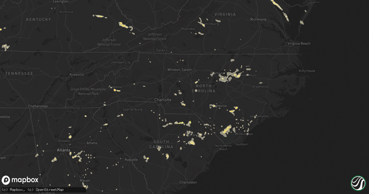
Hail Map in North Carolina on June 18, 2015
Get this storm
June 18 map
$229
one time, instant access
Download today. No call, no setup
Keep the $229
Bought the map and want the full workflow? Apply the entire $229 to a subscription within 7 days. None of it is wasted.
Every map, not just this one
This buys you this map. Subscription and you get every map we run, in the markets you choose from a few cities to whole states to nationwide. Plus real-time alerts the moment a storm fires.
Contact data
Name, contact info, occupancy, even credit band for addresses in the footprint. You go from where it hit to who to call.
Become the source they trust
Unlimited branding weather history reports on demand. You already have the documented answer ready for the property owner, and you are the one who showed up with it.
Property data and RoofTrace estimates
Pull up any address you have got, its value and the exact code rules for that jurisdiction, straight from One Click Code. Then RoofTrace estimates the squares, pitch, and roof value, priced the way you price.
Storm reports in North Carolina
North Carolina
| Date | Description |
|---|---|
| 06/18/20156:59 PM CDT | Juniper st near juniper court. |
| 06/18/20156:20 PM CDT | Two trees blown down and at least a couple power lines down. |
| 06/18/20155:55 PM CDT | 3 foot dimater oak tree toppled over onto home. |
| 06/18/20155:30 PM CDT | Tree blown over in yard on lakeshore drive |
| 06/18/20155:21 PM CDT | A local report indicates 62 MPH wind near WRIGHTSBORO |
| 06/18/20155:00 PM CDT | 1 tree down on cemetary road. Time estimated based on radar. |
| 06/18/20154:55 PM CDT | Tree down across jockey road. Time estimated based off radar. |
| 06/18/20154:23 PM CDT | Report of tree down on the 700 block of tart rd. Time of event estimated by radar. |
| 06/18/20154:21 PM CDT | Possible tornado touchdown at westpark shopping center on richlands highway. |
| 06/18/20154:21 PM CDT | Law enforcement reported tree limb down... Not consistent with a tornado touchdown at westpark shopping center on richlands highway. |
| 06/18/20154:13 PM CDT | Report of tree down on bud stephens rd. Time estimated by radar. |
| 06/18/20154:10 PM CDT | Spotter reported tree and several large tree limbs down around aragona blvd. |
| 06/18/20154:01 PM CDT | Several trees down...a few of them bradford pears. |
| 06/18/20154:00 PM CDT | Tree snapped on stag park road near jordans church. |
| 06/18/20153:45 PM CDT | Two trees were reported down near needmore road just south of turkey. |
| 06/18/20153:44 PM CDT | Several trees down..one across a house...on floyd and fisher drive |
| 06/18/20153:41 PM CDT | Several large limbs blown down and a large bench swing blown over and damaged. |
| 06/18/20153:40 PM CDT | Tree down on route 109. |
| 06/18/20153:32 PM CDT | Downed tree blocking both lanes of mcneil road. Dot dispatched to remove tree. |
| 06/18/20153:30 PM CDT | Tree snapped in half in residents yard off blue clay road |
| 06/18/20153:30 PM CDT | Approximately 20 trees were reported down near the taylors bridge community south of clinton. |
| 06/18/20153:25 PM CDT | One tree was reported down on a house near the intersection of u.s. Highway 401 and edmond matthis road. |
| 06/18/20153:17 PM CDT | A tree that was a foot in diameter fell near the intersection of valley trail road and jamestown road. |
| 06/18/20153:15 PM CDT | Multiple trees down at the intersection of morning star church road and tallent road. |
| 06/18/20153:10 PM CDT | Several large limbs blown down at silver creek plantation golf course. Radar velocity image gave the time. |
| 06/18/20152:30 PM CDT | Raeford road near skibo road |
| 06/18/20151:32 PM CDT | Golf ball size hail at biltmore park in arden. |
| 06/18/20151:30 PM CDT | Largest stones. Average size was 1.25 inch diameter. |
| 06/18/201512:22 PM CDT | First report. Several trees down around mill spring and near columbus. Trees down on moore rd...john shehan rd...and near polk central school. |
| 06/17/20157:46 PM CDT | Tree down blocking the roadway near sunset ave and western ave in rocky mount. |
| 06/17/20157:45 PM CDT | Tree down on franklin street at park place. Report from wral traffic. |
| 06/17/20157:44 PM CDT | Power lines and trees down near the intersection of jones feery road and nc 54 bypass. |
| 06/17/20157:43 PM CDT | Numerous reports of trees down across rocky mount. |
| 06/17/20157:35 PM CDT | Tree down on clover c farm. Time estimated by radar. |
| 06/17/20157:30 PM CDT | Tree down on house on dump horton road. |
| 06/17/20157:28 PM CDT | Power lines were reported down near the intersection of hiwy 58 and boddie mill pond road. |
| 06/17/20157:05 PM CDT | At crabtree valley mall |
All States Impacted by Hail Map on June 18, 2015
Cities Impacted by Hail Map on June 18, 2015
- Petersburg, TX
- Falmouth, KY
- Foster, KY
- Middlesex, NC
- Spring Hope, NC
- Clermont, FL
- Lubbock, TX
- Levelland, TX
- Ropesville, TX
- Meadow, TX
- Mosquero, NM
- Suwanee, GA
- Cumming, GA
- Alpharetta, GA
- Arthur, IL
- Greenfield, IN
- Lebanon, TN
- Hartsville, TN
- Ranburne, AL
- Hale Center, TX
- Plainview, TX
- Roswell, NM
- Cameron, SC
- Alcolu, SC
- Killeen, TX
- Fort Hood, TX
- Saint Albans, WV
- Hurricane, WV
- Hallsboro, NC
- Forsyth, GA
- Marion, SC
- Stanley, ND
- Lamar, SC
- Eustis, FL
- Kershaw, SC
- Miami, TX
- Whiteland, IN
- Arden, NC
- Asheville, NC
- Conyers, GA
- Mcdonough, GA
- Covington, GA
- Adrian, TX
- Slaton, TX
- New Paris, OH
- Eldorado, OH
- Eaton, OH
- Greenville, SC
- Mauldin, SC
- Simpsonville, SC
- Jefferson, SC
- McBee, SC
- Bethune, SC
- Lamar, CO
- Decker, MT
- Higgins, TX
- Rocky Mount, NC
- Mullins, SC
- Townville, SC
- Rolla, KS
- Herndon, VA
- Fairfax, VA
- Sumter, SC
- Mayesville, SC
- Dunnellon, FL
- Dalhart, TX
- Bard, NM
- Society Hill, SC
- Cheraw, SC
- Sturgis, SD
- Whitewood, SD
- Fort Meade, SD
- Oakton, VA
- Chantilly, VA
- Maple Hill, NC
- Cobbs Creek, VA
- Hartfield, VA
- Hardyville, VA
- Seale, AL
- Andrews, TX
- Wheatland, WY
- Angola, IN
- Lagrange, IN
- Howe, IN
- Fort Garland, CO
- Raeford, NC
- Fayetteville, NC
- Atkinson, NC
- Marion, VA
- Raleigh, NC
- Centreville, VA
- Annandale, VA
- Sterling, VA
- Springfield, VA
- Burke, VA
- Clifton, VA
- Reston, VA
- Uniontown, OH
- Akron, OH
- Damascus, MD
- Germantown, MD
- Gaithersburg, MD
- Newport, TN
- Bybee, TN
- White Pine, TN
- Absarokee, MT
- Bowie, MD
- Upper Marlboro, MD
- Machipongo, VA
- Franktown, VA
- Exmore, VA
- Nassawadox, VA
- Birdsnest, VA
- Warsaw, VA
- Champlain, VA
- Birney, MT
- Leicester, NC
- Whiteville, NC
- Council, NC
- Lake Waccamaw, NC
- Clarkton, NC
- Roanoke, AL
- Lafayette, AL
- Vienna, VA
- Forest, VA
- Lowry, VA
- Natural Bridge Station, VA
- Goode, VA
- Bedford, VA
- Robbins, NC
- Seagrove, NC
- Junction, TX
- Perryton, TX
- Plains, TX
- Kenbridge, VA
- Idalou, TX
- Lorenzo, TX
- Louisburg, NC
- Zebulon, NC
- Bunn, NC
- Bosler, WY
- Buckhead, GA
- Greensboro, GA
- Fredericksburg, TX
- Fair Play, SC
- Hartley, TX
- Loudon, TN
- Vega, TX
- Bruceton Mills, WV
- Albright, WV
- Ramseur, NC
- Asheboro, NC
- Franklinville, NC
- Danville, IL
- Perrysville, IN
- Georgetown, IL
- Scranton, SC
- Coward, SC
- Madison, GA
- Deland, FL
- Mount Pleasant, NC
- Brandon, FL
- Riverview, FL
- Tampa, FL
- Paisley, FL
- Altoona, FL
- Richmond, IN
- Brooksville, KY
- Mount Olivet, KY
- Fletcher, NC
- Gerton, NC
- Fairview, NC
- Florissant, CO
- Currie, NC
- Wyola, MT
- Lodge Grass, MT
- Otter, MT
- Busby, MT
- Heflin, AL
- Muscadine, AL
- Doss, TX
- Lehigh Acres, FL
- Dawson, GA
- Canon City, CO
- Chapel Hill, NC
- Hyattsville, MD
- Andrews, SC
- Elloree, SC
- Church Creek, MD
- Fishing Creek, MD
- Heath Springs, SC
- Waldorf, MD
- Morgantown, KY
- Rochester, KY
- Berry, KY
- Cynthiana, KY
- Kempner, TX
- Copperas Cove, TX
- Dickerson, MD
- Ijamsville, MD
- Frederick, MD
- Clarksburg, MD
- Springfield, SC
- Williston, SC
- Lick Creek, KY
- Big Rock, VA
- Mouthcard, KY
- Grundy, VA
- Pilgrims Knob, VA
- Oakwood, VA
- Raven, VA
- Leland, NC
- Wagener, SC
- Windsor, SC
- Aiken, SC
- Interlachen, FL
- Florahome, FL
- Palatka, FL
- Keystone Heights, FL
- Clarkesville, GA
- Boston, IN
- Liberty, IN
- Elida, NM
- Glenelg, MD
- Woodbine, MD
- Glenwood, MD
- Coleman, GA
- Franklin, IN
- Bargersville, IN
- Adamstown, MD
- Monroe, VA
- Walnut Cove, NC
- Lanett, AL
- Clinton, NC
- Garland, NC
- Moneta, VA
- San Jon, NM
- Bethel, NC
- Greenville, NC
- Robersonville, NC
- Stokes, NC
- Louisville, CO
- Broomfield, CO
- South Boston, VA
- Carrboro, NC
- Belle Fourche, SD
- Burgaw, NC
- Monticello, GA
- Crossville, TN
- Canadian, TX
- Mobeetie, TX
- Nicholson, GA
- Commerce, GA
- Mansfield, GA
- Lake Butler, FL
- Brooker, FL
- Wildorado, TX
- Social Circle, GA
- Dry Ridge, KY
- Philadelphia, TN
- Warsaw, NC
- Jackson, KY
- Salyersville, KY
- Rousseau, KY
- Turkey, NC
- Harrodsburg, KY
- Gray, GA
- Cincinnati, OH
- Edgemoor, SC
- Portales, NM
- Floyd, NM
- Florence, CO
- Connelly Springs, NC
- Vale, NC
- Five Points, AL
- Lithonia, GA
- Appomattox, VA
- Gladstone, VA
- Sunray, TX
- Dumas, TX
- Cactus, TX
- Fairland, IN
- New Palestine, IN
- Fountaintown, IN
- Indianapolis, IN
- Bremen, GA
- Mason, TX
- Abernathy, TX
- Phyllis, KY
- Simon, WV
- Verner, WV
- Adrian, GA
- Clarendon, NC
- Chadbourn, NC
- Bolton, NC
- Nakina, NC
- Riegelwood, NC
- Olanta, SC
- Timmonsville, SC
- Lake City, SC
- Lafayette, CO
- Sparta, TN
- Cookeville, TN
- Silver Spring, MD
- Olney, MD
- Derwood, MD
- Rockville, MD
- Enfield, NC
- Fort Washington, MD
- Clinton, MD
- Brandywine, MD
- Accokeek, MD
- Owenton, KY
- Wheeler, TX
- La Grange, KY
- Goshen, KY
- Monterey, TN
- Brooksville, FL
- Spring Hill, FL
- Warner Robins, GA
- Macon, GA
- Sundance, WY
- Loveland, OH
- Hartsville, SC
- Patrick, SC
- Lakemore, OH
- Newnan, GA
- Port Clinton, OH
- Lacarne, OH
- Clear Fork, WV
- Balko, OK
- Tahoka, TX
- Crosbyton, TX
- Columbus, MT
- Marion, OH
- Prospect, OH
- Wadesboro, NC
- Norwood, NC
- Autryville, NC
- Roseboro, NC
- Orrum, NC
- Deltaville, VA
- Topping, VA
- Wake, VA
- Weems, VA
- Salem, OH
- Deputy, IN
- Lexington, IN
- Austin, IN
- Scottsburg, IN
- Candler, NC
- Dillon, SC
- Tallapoosa, GA
- Buchanan, GA
- Ararat, VA
- Castalia, NC
- Lake Panasoffkee, FL
- Vancleve, KY
- Bays, KY
- Gunlock, KY
- Billings, MT
- Alzada, MT
- Broadus, MT
- Gatesville, TX
- Lewisburg, OH
- New London, NC
- Richfield, NC
- Mechanicsville, MD
- Aquasco, MD
- Hughesville, MD
- Charlotte Hall, MD
- Suitland, MD
- District Heights, MD
- Lilburn, GA
- Norcross, GA
- Knightdale, NC
- Ransom Canyon, TX
- Vickery, OH
- Fremont, OH
- Ralls, TX
- Dandridge, TN
- Wrightsville Beach, NC
- Wilmington, NC
- Saint Xavier, MT
- Sylvester, GA
- Creedmoor, NC
- Ellerbe, NC
- Candor, NC
- Beloit, OH
- Lovington, IL
- Richburg, SC
- Jacksonville, NC
- Dearing, GA
- Bronwood, GA
- Nye, MT
- Knoxville, TN
- Farnham, VA
- Lancaster, VA
- Tappahannock, VA
- Dawsonville, GA
- Rutledge, GA
- McLeod, MT
- Beechmont, KY
- Drakesboro, KY
- Beaver Dam, KY
- Browder, KY
- Belton, KY
- Kress, TX
- Roberta, GA
- Staley, NC
- Polkton, NC
- Ansonville, NC
- Florence, SC
- Concord, VA
- Madison Heights, VA
- Amherst, VA
- Gaston, SC
- Swansea, SC
- Hendersonville, NC
- Seffner, FL
- Harrells, NC
- Rose Hill, NC
- Weston, WY
- Sonora, TX
- Prince Frederick, MD
- Benedict, MD
- Bowersville, GA
- Darlington, SC
- Wake Forest, NC
- Knightstown, IN
- Carthage, IN
- Lewisville, IN
- Rocky Point, NC
- Fort Branch, IN
- Nebo, NC
- Morganton, NC
- Wolfforth, TX
- Jackson, GA
- Springfield, CO
- Labelle, FL
- Jetson, KY
- Oxford, GA
- Jonesville, KY
- New Liberty, KY
- Durham, NC
- Friona, TX
- Cordele, GA
- Unadilla, GA
- Vienna, GA
- Pinehurst, GA
- Centerville, IN
- Hartwell, GA
- Lynch Station, VA
- Ashburn, VA
- Franklin, KY
- Bowling Green, KY
- Radnor, OH
- Richwood, OH
- Steele, KY
- Elkhorn City, KY
- Regina, KY
- Belcher, KY
- Palmetto, GA
- Sharpsburg, GA
- Fishtail, MT
- Lancaster, SC
- Hulett, WY
- Bowdon, GA
- Punta Gorda, FL
- Arvada, WY
- Swords Creek, VA
- Wilmore, KY
- Folkston, GA
- Rushville, IN
- Spiceland, IN
- Hope, MI
- Rhodes, MI
- Beaverton, MI
- Mayhill, NM
- Bishopville, SC
- Scottsville, KY
- Mitchell, GA
- Warthen, GA
- Sparta, GA
- Valrico, FL
- Willard, NC
- Matthews, GA
- Llano, TX
- Sweetwater, OK
- Aldie, VA
- Leesburg, VA
- Falls Church, VA
- Alexandria, VA
- Arlington, VA
- Dunn Loring, VA
- Albemarle, NC
- Corinth, KY
- Raccoon, KY
- Pikeville, KY
- Live Oak, FL
- Dublin, GA
- Barnesville, GA
- The Rock, GA
- Ellicott City, MD
- Dayton, MD
- West Friendship, MD
- Arcadia, FL
- Rowland, NC
- Glencoe, KY
- Rowe, VA
- Sevierville, TN
- Eatonton, GA
- Logansport, IN
- Royal Center, IN
- Lockney, TX
- Nashville, NC
- Huddleston, VA
- Mason, OH
- West Chester, OH
- Rockville, IN
- Dadeville, AL
- Scotland Neck, NC
- Gresham, SC
- Dallas, GA
- Beltsville, MD
- College Park, MD
- Livingston, TN
- Stockbridge, GA
- Westcliffe, CO
- Morristown, TN
- Saint Matthews, SC
- Orangeburg, SC
- Floydada, TX
- Greenbush, VA
- Onancock, VA
- Accomac, VA
- Fairmont, NC
- Potomac, MD
- Garrett Park, MD
- Kensington, MD
- Bethesda, MD
- Louisville, KY
- Rolesville, NC
- Youngsville, NC
- Hamer, SC
- Ivanhoe, NC
- Keyes, OK
- Gibson, GA
- Hardy, VA
- Ellenwood, GA
- Goodwell, OK
- King, NC
- Cary, NC
- Morrisville, NC
- Clio, SC
- Effingham, SC
- Turbeville, SC
- Sebring, OH
- North Benton, OH
- Cotopaxi, CO
- Erick, OK
- Brevard, NC
- Whitakers, NC
- Ocala, FL
- Hudson, FL
- Groveland, FL
- Montross, VA
- Lenoir City, TN
- Greenwood, SC
- Ozona, TX
- Spearfish, SD
- Wendell, NC
- Pittsboro, NC
- Liberty Hill, SC
- Camden, SC
- Waynesboro, PA
- Fairfield, PA
- Blue Ridge Summit, PA
- Hampstead, NC
- Saint Leonard, MD
- Jefferson, NC
- Buckeystown, MD
- Jefferson, MD
- Monrovia, MD
- Mount Airy, MD
- Middletown, MD
- Piedmont, SC
- Canon, GA
- Royston, GA
- Cerro Gordo, NC
- Fair Bluff, NC
- Rockwood, TN
- Oakdale, TN
- Nichols, SC
- Quitman, GA
- Pavo, GA
- Alva, FL
- Mogadore, OH
- Barberton, OH
- Washington, GA
- Athens, GA
- Centerville, GA
- Byron, GA
- Falmouth, IN
- Straughn, IN
- Pembroke, NC
- Hallieford, VA
- Irvington, VA
- White Stone, VA
- Chesapeake Beach, MD
- Huntingtown, MD
- Castle Hayne, NC
- Hillsboro, GA
- Jacksonville, FL
- Golden, CO
- Arvada, CO
- Poolesville, MD
- York, SC
- Battletown, KY
- Leavenworth, IN
- Hawthorne, FL
- Moorcroft, WY
- McConnells, SC
- Rock Hill, SC
- Martin, KY
- David, KY
- Prestonsburg, KY
- Portland, TN
- Woodburn, KY
- Waldo, FL
- New Zion, SC
- New Market, TN
- Jefferson City, TN
- Beulah, CO
- Brentwood, MD
- Takoma Park, MD
- Mount Rainier, MD
- Washington, DC
- Chevy Chase, MD
- Henderson, NC
- Salem, IN
- Clayton, NM
- Phenix City, AL
- Haddock, GA
- Milledgeville, GA
- Pineview, GA
- Waterford, VA
- Paeonian Springs, VA
- Hamilton, VA
- Felt, OK
- Lake Toxaway, NC
- Lumpkin, GA
- Greenwood, IN
- Hawkinsville, GA
- Clarksville, MD
- Brookeville, MD
- Warrenton, GA
- Stapleton, GA
- Hamilton, GA
- Cataula, GA
- Appling, GA
- Harlem, GA
- Oglesby, TX
- Kelly, NC
- Delco, NC
- Lynchburg, SC
- Reynolds, GA
- Butler, GA
- Lexington, NC
- Fork, SC
- Carrollton, GA
- Dover, FL
- Thonotosassa, FL
- Boyds, MD
- Hawesville, KY
- Franklinton, NC
- Millers Creek, NC
- La Fayette, GA
- Apex, NC
- Tulia, TX
- Astor, FL


