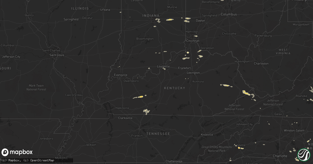
Hail Map in Kentucky on June 18, 2015
Get this storm
June 18 map
$229
one time, instant access
Download today. No call, no setup
Keep the $229
Bought the map and want the full workflow? Apply the entire $229 to a subscription within 7 days. None of it is wasted.
Every map, not just this one
This buys you this map. Subscription and you get every map we run, in the markets you choose from a few cities to whole states to nationwide. Plus real-time alerts the moment a storm fires.
Contact data
Name, contact info, occupancy, even credit band for addresses in the footprint. You go from where it hit to who to call.
Become the source they trust
Unlimited branding weather history reports on demand. You already have the documented answer ready for the property owner, and you are the one who showed up with it.
Property data and RoofTrace estimates
Pull up any address you have got, its value and the exact code rules for that jurisdiction, straight from One Click Code. Then RoofTrace estimates the squares, pitch, and roof value, priced the way you price.
Storm reports in Kentucky
Kentucky
| Date | Description |
|---|---|
| 06/18/20155:45 PM CDT | 2 trees down and an electrical line down in the lexington area. |
| 06/18/20155:22 PM CDT | Tree across shannon run rd. And another on fords mill rd. |
| 06/18/20155:15 PM CDT | Fireworks tent at 127 and 62 damaged. Steel pole blew over. |
| 06/18/20155:13 PM CDT | Roof blown off of a daycare. Also... Damage to another business reported. |
| 06/18/20155:00 PM CDT | Tree down at millard on highway 460. |
| 06/18/20154:15 PM CDT | Tree fell and collapsed roof on house in the spring creek ct area. Metrosafe also reported trees down at manchester and lake side as well as taylor and illinois. |
| 06/18/20154:00 PM CDT | Utility pole snapped off at ground. |
| 06/18/20153:54 PM CDT | Tree down at 1800 hillview boulevard. Time estimated from radar. |
| 06/18/20153:52 PM CDT | Reported tree down on car as well as another tree down on brooks schoolhouse road in area of golf course. Time estimated based on radar. |
| 06/18/20153:45 PM CDT | Barn blown down on ky-36 1 mile west of cynthiana. Another report of a tree across roadway just east of cynthiana as well. Time approximated based on radar. |
| 06/18/20153:44 PM CDT | Tree down on road near milby lane and hawkins rd. Time estimated based on radar. |
| 06/18/20153:29 PM CDT | Tree down on clifty ave. In clarkson. |
| 06/18/20153:12 PM CDT | Portions of metal roof blown off of house |
| 06/18/20152:39 PM CDT | Report relayed from viewer. |
| 06/18/20152:34 PM CDT | Twitter report of tree falling near a house. Time estimated based on radar. |
| 06/18/20152:30 PM CDT | Tree down on highway 1840. |
| 06/18/20152:21 PM CDT | Quarter sized hail reported in louisa. Relayed via nws jackson ky. |
| 06/18/20152:15 PM CDT | Tree down on highway 1353 near madison county line. |
| 06/18/20152:11 PM CDT | Twitter report passed along of several trees down along the 10000 block of barren river rd. |
| 06/18/20152:07 PM CDT | Tree blown down onto power line. |
| 06/18/20151:57 PM CDT | Tree down across highway 36. Time estimated from radar |
| 06/18/20151:42 PM CDT | Tree knocked down on john england road and kentucky 165. Time estimated from radar. |
| 06/18/20151:37 PM CDT | Trees down across trice road. Time estimated based on radar. |
| 06/18/20151:20 PM CDT | Trees reported down on maple street.. |
| 06/18/20151:11 PM CDT | Multiple trees down along belmont road. Time estimated from radar. |
| 06/18/20151:11 PM CDT | Tree knocked down at jacobs road and bellmont road. Time estimated from radar. |
| 06/18/20151:10 PM CDT | Large tree down across a portion of ky-19. |
| 06/18/20151:07 PM CDT | Tree knocked down at cemetary road and highway 127. Time estimated from radar. |
| 06/18/201512:36 PM CDT | Half a dozen shingles blown off of weather office roof. |
All States Impacted by Hail Map on June 18, 2015
Cities Impacted by Hail Map on June 18, 2015
- Petersburg, TX
- Falmouth, KY
- Foster, KY
- Middlesex, NC
- Spring Hope, NC
- Clermont, FL
- Lubbock, TX
- Levelland, TX
- Ropesville, TX
- Meadow, TX
- Mosquero, NM
- Suwanee, GA
- Cumming, GA
- Alpharetta, GA
- Arthur, IL
- Greenfield, IN
- Lebanon, TN
- Hartsville, TN
- Ranburne, AL
- Hale Center, TX
- Plainview, TX
- Roswell, NM
- Cameron, SC
- Alcolu, SC
- Killeen, TX
- Fort Hood, TX
- Saint Albans, WV
- Hurricane, WV
- Hallsboro, NC
- Forsyth, GA
- Marion, SC
- Stanley, ND
- Lamar, SC
- Eustis, FL
- Kershaw, SC
- Miami, TX
- Whiteland, IN
- Arden, NC
- Asheville, NC
- Conyers, GA
- Mcdonough, GA
- Covington, GA
- Adrian, TX
- Slaton, TX
- New Paris, OH
- Eldorado, OH
- Eaton, OH
- Greenville, SC
- Mauldin, SC
- Simpsonville, SC
- Jefferson, SC
- McBee, SC
- Bethune, SC
- Lamar, CO
- Decker, MT
- Higgins, TX
- Rocky Mount, NC
- Mullins, SC
- Townville, SC
- Rolla, KS
- Herndon, VA
- Fairfax, VA
- Sumter, SC
- Mayesville, SC
- Dunnellon, FL
- Dalhart, TX
- Bard, NM
- Society Hill, SC
- Cheraw, SC
- Sturgis, SD
- Whitewood, SD
- Fort Meade, SD
- Oakton, VA
- Chantilly, VA
- Maple Hill, NC
- Cobbs Creek, VA
- Hartfield, VA
- Hardyville, VA
- Seale, AL
- Andrews, TX
- Wheatland, WY
- Angola, IN
- Lagrange, IN
- Howe, IN
- Fort Garland, CO
- Raeford, NC
- Fayetteville, NC
- Atkinson, NC
- Marion, VA
- Raleigh, NC
- Centreville, VA
- Annandale, VA
- Sterling, VA
- Springfield, VA
- Burke, VA
- Clifton, VA
- Reston, VA
- Uniontown, OH
- Akron, OH
- Damascus, MD
- Germantown, MD
- Gaithersburg, MD
- Newport, TN
- Bybee, TN
- White Pine, TN
- Absarokee, MT
- Bowie, MD
- Upper Marlboro, MD
- Machipongo, VA
- Franktown, VA
- Exmore, VA
- Nassawadox, VA
- Birdsnest, VA
- Warsaw, VA
- Champlain, VA
- Birney, MT
- Leicester, NC
- Whiteville, NC
- Council, NC
- Lake Waccamaw, NC
- Clarkton, NC
- Roanoke, AL
- Lafayette, AL
- Vienna, VA
- Forest, VA
- Lowry, VA
- Natural Bridge Station, VA
- Goode, VA
- Bedford, VA
- Robbins, NC
- Seagrove, NC
- Junction, TX
- Perryton, TX
- Plains, TX
- Kenbridge, VA
- Idalou, TX
- Lorenzo, TX
- Louisburg, NC
- Zebulon, NC
- Bunn, NC
- Bosler, WY
- Buckhead, GA
- Greensboro, GA
- Fredericksburg, TX
- Fair Play, SC
- Hartley, TX
- Loudon, TN
- Vega, TX
- Bruceton Mills, WV
- Albright, WV
- Ramseur, NC
- Asheboro, NC
- Franklinville, NC
- Danville, IL
- Perrysville, IN
- Georgetown, IL
- Scranton, SC
- Coward, SC
- Madison, GA
- Deland, FL
- Mount Pleasant, NC
- Brandon, FL
- Riverview, FL
- Tampa, FL
- Paisley, FL
- Altoona, FL
- Richmond, IN
- Brooksville, KY
- Mount Olivet, KY
- Fletcher, NC
- Gerton, NC
- Fairview, NC
- Florissant, CO
- Currie, NC
- Wyola, MT
- Lodge Grass, MT
- Otter, MT
- Busby, MT
- Heflin, AL
- Muscadine, AL
- Doss, TX
- Lehigh Acres, FL
- Dawson, GA
- Canon City, CO
- Chapel Hill, NC
- Hyattsville, MD
- Andrews, SC
- Elloree, SC
- Church Creek, MD
- Fishing Creek, MD
- Heath Springs, SC
- Waldorf, MD
- Morgantown, KY
- Rochester, KY
- Berry, KY
- Cynthiana, KY
- Kempner, TX
- Copperas Cove, TX
- Dickerson, MD
- Ijamsville, MD
- Frederick, MD
- Clarksburg, MD
- Springfield, SC
- Williston, SC
- Lick Creek, KY
- Big Rock, VA
- Mouthcard, KY
- Grundy, VA
- Pilgrims Knob, VA
- Oakwood, VA
- Raven, VA
- Leland, NC
- Wagener, SC
- Windsor, SC
- Aiken, SC
- Interlachen, FL
- Florahome, FL
- Palatka, FL
- Keystone Heights, FL
- Clarkesville, GA
- Boston, IN
- Liberty, IN
- Elida, NM
- Glenelg, MD
- Woodbine, MD
- Glenwood, MD
- Coleman, GA
- Franklin, IN
- Bargersville, IN
- Adamstown, MD
- Monroe, VA
- Walnut Cove, NC
- Lanett, AL
- Clinton, NC
- Garland, NC
- Moneta, VA
- San Jon, NM
- Bethel, NC
- Greenville, NC
- Robersonville, NC
- Stokes, NC
- Louisville, CO
- Broomfield, CO
- South Boston, VA
- Carrboro, NC
- Belle Fourche, SD
- Burgaw, NC
- Monticello, GA
- Crossville, TN
- Canadian, TX
- Mobeetie, TX
- Nicholson, GA
- Commerce, GA
- Mansfield, GA
- Lake Butler, FL
- Brooker, FL
- Wildorado, TX
- Social Circle, GA
- Dry Ridge, KY
- Philadelphia, TN
- Warsaw, NC
- Jackson, KY
- Salyersville, KY
- Rousseau, KY
- Turkey, NC
- Harrodsburg, KY
- Gray, GA
- Cincinnati, OH
- Edgemoor, SC
- Portales, NM
- Floyd, NM
- Florence, CO
- Connelly Springs, NC
- Vale, NC
- Five Points, AL
- Lithonia, GA
- Appomattox, VA
- Gladstone, VA
- Sunray, TX
- Dumas, TX
- Cactus, TX
- Fairland, IN
- New Palestine, IN
- Fountaintown, IN
- Indianapolis, IN
- Bremen, GA
- Mason, TX
- Abernathy, TX
- Phyllis, KY
- Simon, WV
- Verner, WV
- Adrian, GA
- Clarendon, NC
- Chadbourn, NC
- Bolton, NC
- Nakina, NC
- Riegelwood, NC
- Olanta, SC
- Timmonsville, SC
- Lake City, SC
- Lafayette, CO
- Sparta, TN
- Cookeville, TN
- Silver Spring, MD
- Olney, MD
- Derwood, MD
- Rockville, MD
- Enfield, NC
- Fort Washington, MD
- Clinton, MD
- Brandywine, MD
- Accokeek, MD
- Owenton, KY
- Wheeler, TX
- La Grange, KY
- Goshen, KY
- Monterey, TN
- Brooksville, FL
- Spring Hill, FL
- Warner Robins, GA
- Macon, GA
- Sundance, WY
- Loveland, OH
- Hartsville, SC
- Patrick, SC
- Lakemore, OH
- Newnan, GA
- Port Clinton, OH
- Lacarne, OH
- Clear Fork, WV
- Balko, OK
- Tahoka, TX
- Crosbyton, TX
- Columbus, MT
- Marion, OH
- Prospect, OH
- Wadesboro, NC
- Norwood, NC
- Autryville, NC
- Roseboro, NC
- Orrum, NC
- Deltaville, VA
- Topping, VA
- Wake, VA
- Weems, VA
- Salem, OH
- Deputy, IN
- Lexington, IN
- Austin, IN
- Scottsburg, IN
- Candler, NC
- Dillon, SC
- Tallapoosa, GA
- Buchanan, GA
- Ararat, VA
- Castalia, NC
- Lake Panasoffkee, FL
- Vancleve, KY
- Bays, KY
- Gunlock, KY
- Billings, MT
- Alzada, MT
- Broadus, MT
- Gatesville, TX
- Lewisburg, OH
- New London, NC
- Richfield, NC
- Mechanicsville, MD
- Aquasco, MD
- Hughesville, MD
- Charlotte Hall, MD
- Suitland, MD
- District Heights, MD
- Lilburn, GA
- Norcross, GA
- Knightdale, NC
- Ransom Canyon, TX
- Vickery, OH
- Fremont, OH
- Ralls, TX
- Dandridge, TN
- Wrightsville Beach, NC
- Wilmington, NC
- Saint Xavier, MT
- Sylvester, GA
- Creedmoor, NC
- Ellerbe, NC
- Candor, NC
- Beloit, OH
- Lovington, IL
- Richburg, SC
- Jacksonville, NC
- Dearing, GA
- Bronwood, GA
- Nye, MT
- Knoxville, TN
- Farnham, VA
- Lancaster, VA
- Tappahannock, VA
- Dawsonville, GA
- Rutledge, GA
- McLeod, MT
- Beechmont, KY
- Drakesboro, KY
- Beaver Dam, KY
- Browder, KY
- Belton, KY
- Kress, TX
- Roberta, GA
- Staley, NC
- Polkton, NC
- Ansonville, NC
- Florence, SC
- Concord, VA
- Madison Heights, VA
- Amherst, VA
- Gaston, SC
- Swansea, SC
- Hendersonville, NC
- Seffner, FL
- Harrells, NC
- Rose Hill, NC
- Weston, WY
- Sonora, TX
- Prince Frederick, MD
- Benedict, MD
- Bowersville, GA
- Darlington, SC
- Wake Forest, NC
- Knightstown, IN
- Carthage, IN
- Lewisville, IN
- Rocky Point, NC
- Fort Branch, IN
- Nebo, NC
- Morganton, NC
- Wolfforth, TX
- Jackson, GA
- Springfield, CO
- Labelle, FL
- Jetson, KY
- Oxford, GA
- Jonesville, KY
- New Liberty, KY
- Durham, NC
- Friona, TX
- Cordele, GA
- Unadilla, GA
- Vienna, GA
- Pinehurst, GA
- Centerville, IN
- Hartwell, GA
- Lynch Station, VA
- Ashburn, VA
- Franklin, KY
- Bowling Green, KY
- Radnor, OH
- Richwood, OH
- Steele, KY
- Elkhorn City, KY
- Regina, KY
- Belcher, KY
- Palmetto, GA
- Sharpsburg, GA
- Fishtail, MT
- Lancaster, SC
- Hulett, WY
- Bowdon, GA
- Punta Gorda, FL
- Arvada, WY
- Swords Creek, VA
- Wilmore, KY
- Folkston, GA
- Rushville, IN
- Spiceland, IN
- Hope, MI
- Rhodes, MI
- Beaverton, MI
- Mayhill, NM
- Bishopville, SC
- Scottsville, KY
- Mitchell, GA
- Warthen, GA
- Sparta, GA
- Valrico, FL
- Willard, NC
- Matthews, GA
- Llano, TX
- Sweetwater, OK
- Aldie, VA
- Leesburg, VA
- Falls Church, VA
- Alexandria, VA
- Arlington, VA
- Dunn Loring, VA
- Albemarle, NC
- Corinth, KY
- Raccoon, KY
- Pikeville, KY
- Live Oak, FL
- Dublin, GA
- Barnesville, GA
- The Rock, GA
- Ellicott City, MD
- Dayton, MD
- West Friendship, MD
- Arcadia, FL
- Rowland, NC
- Glencoe, KY
- Rowe, VA
- Sevierville, TN
- Eatonton, GA
- Logansport, IN
- Royal Center, IN
- Lockney, TX
- Nashville, NC
- Huddleston, VA
- Mason, OH
- West Chester, OH
- Rockville, IN
- Dadeville, AL
- Scotland Neck, NC
- Gresham, SC
- Dallas, GA
- Beltsville, MD
- College Park, MD
- Livingston, TN
- Stockbridge, GA
- Westcliffe, CO
- Morristown, TN
- Saint Matthews, SC
- Orangeburg, SC
- Floydada, TX
- Greenbush, VA
- Onancock, VA
- Accomac, VA
- Fairmont, NC
- Potomac, MD
- Garrett Park, MD
- Kensington, MD
- Bethesda, MD
- Louisville, KY
- Rolesville, NC
- Youngsville, NC
- Hamer, SC
- Ivanhoe, NC
- Keyes, OK
- Gibson, GA
- Hardy, VA
- Ellenwood, GA
- Goodwell, OK
- King, NC
- Cary, NC
- Morrisville, NC
- Clio, SC
- Effingham, SC
- Turbeville, SC
- Sebring, OH
- North Benton, OH
- Cotopaxi, CO
- Erick, OK
- Brevard, NC
- Whitakers, NC
- Ocala, FL
- Hudson, FL
- Groveland, FL
- Montross, VA
- Lenoir City, TN
- Greenwood, SC
- Ozona, TX
- Spearfish, SD
- Wendell, NC
- Pittsboro, NC
- Liberty Hill, SC
- Camden, SC
- Waynesboro, PA
- Fairfield, PA
- Blue Ridge Summit, PA
- Hampstead, NC
- Saint Leonard, MD
- Jefferson, NC
- Buckeystown, MD
- Jefferson, MD
- Monrovia, MD
- Mount Airy, MD
- Middletown, MD
- Piedmont, SC
- Canon, GA
- Royston, GA
- Cerro Gordo, NC
- Fair Bluff, NC
- Rockwood, TN
- Oakdale, TN
- Nichols, SC
- Quitman, GA
- Pavo, GA
- Alva, FL
- Mogadore, OH
- Barberton, OH
- Washington, GA
- Athens, GA
- Centerville, GA
- Byron, GA
- Falmouth, IN
- Straughn, IN
- Pembroke, NC
- Hallieford, VA
- Irvington, VA
- White Stone, VA
- Chesapeake Beach, MD
- Huntingtown, MD
- Castle Hayne, NC
- Hillsboro, GA
- Jacksonville, FL
- Golden, CO
- Arvada, CO
- Poolesville, MD
- York, SC
- Battletown, KY
- Leavenworth, IN
- Hawthorne, FL
- Moorcroft, WY
- McConnells, SC
- Rock Hill, SC
- Martin, KY
- David, KY
- Prestonsburg, KY
- Portland, TN
- Woodburn, KY
- Waldo, FL
- New Zion, SC
- New Market, TN
- Jefferson City, TN
- Beulah, CO
- Brentwood, MD
- Takoma Park, MD
- Mount Rainier, MD
- Washington, DC
- Chevy Chase, MD
- Henderson, NC
- Salem, IN
- Clayton, NM
- Phenix City, AL
- Haddock, GA
- Milledgeville, GA
- Pineview, GA
- Waterford, VA
- Paeonian Springs, VA
- Hamilton, VA
- Felt, OK
- Lake Toxaway, NC
- Lumpkin, GA
- Greenwood, IN
- Hawkinsville, GA
- Clarksville, MD
- Brookeville, MD
- Warrenton, GA
- Stapleton, GA
- Hamilton, GA
- Cataula, GA
- Appling, GA
- Harlem, GA
- Oglesby, TX
- Kelly, NC
- Delco, NC
- Lynchburg, SC
- Reynolds, GA
- Butler, GA
- Lexington, NC
- Fork, SC
- Carrollton, GA
- Dover, FL
- Thonotosassa, FL
- Boyds, MD
- Hawesville, KY
- Franklinton, NC
- Millers Creek, NC
- La Fayette, GA
- Apex, NC
- Tulia, TX
- Astor, FL


