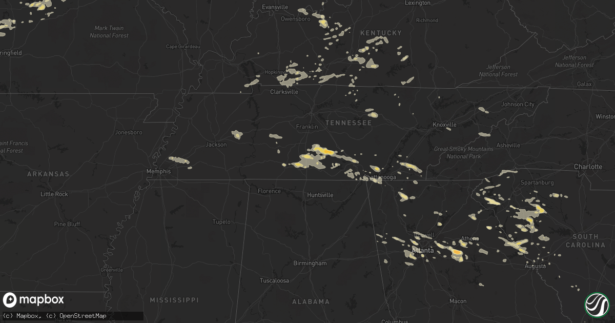
Hail Map in Tennessee on June 18, 2011
Get this storm
June 18 map
$229
one time, instant access
Download today. No call, no setup
Keep the $229
Bought the map and want the full workflow? Apply the entire $229 to a subscription within 7 days. None of it is wasted.
Every map, not just this one
This buys you this map. Subscription and you get every map we run, in the markets you choose from a few cities to whole states to nationwide. Plus real-time alerts the moment a storm fires.
Contact data
Name, contact info, occupancy, even credit band for addresses in the footprint. You go from where it hit to who to call.
Become the source they trust
Unlimited branding weather history reports on demand. You already have the documented answer ready for the property owner, and you are the one who showed up with it.
Property data and RoofTrace estimates
Pull up any address you have got, its value and the exact code rules for that jurisdiction, straight from One Click Code. Then RoofTrace estimates the squares, pitch, and roof value, priced the way you price.
Storm reports in Tennessee
Tennessee
| Date | Description |
|---|---|
| 06/18/20113:25 PM CDT | Numerous trees and power lines down. |
| 06/18/20113:20 PM CDT | 4 trees down. |
| 06/18/20113:15 PM CDT | A local report indicates 1.00 inch wind near CALHOUN |
| 06/18/20113:00 PM CDT | Numerous trees and power lines down. |
| 06/18/20112:37 PM CDT | Numerous trees down in dunlap. Reported by dispatch. |
| 06/18/20112:36 PM CDT | Tree reported down on house along with a tin structure badly damaged. |
| 06/18/20112:20 PM CDT | Trees and powerlines were knocked down in huntland. |
| 06/18/20112:13 PM CDT | Large trees were knocked down on jump off road and on highway 41 in st. Andrews. Time estimated by radar. |
| 06/18/20112:12 PM CDT | A tree was knocked down onto a home in the flintville area on quarters crossroads road. Time and location estimated. |
| 06/18/20112:12 PM CDT | Large trees and branches were knocked down on the campus of the university of the south. Time estimated by radar. |
| 06/18/20112:06 PM CDT | A tree was knocked down on a home in the 400 block of bennett street. Time estimated by radar. |
| 06/18/20112:06 PM CDT | Several trees were knocked on highway 231. Time estimated by radar. |
| 06/18/20112:06 PM CDT | Along prospect road. Fences and trailers were damaged. A 3 foot diameter oak tree was knocked down. Time estimated by radar. |
| 06/18/20112:06 PM CDT | Trees and power lines were knocked down in alto. Time estimated by radar. |
| 06/18/20112:05 PM CDT | A 5 to 6 foot diameter tree was knocked down on monks road. Time estimated by radar. |
| 06/18/20112:03 PM CDT | A 5 foot diameter tree was knocked down on simmons road. Time estimated by radar. |
| 06/18/20112:00 PM CDT | A roof was blown off of a barn in the taft area on highway 110/ardmore highway. Time and location estimated. |
| 06/18/20111:58 PM CDT | Several tree down near chapel hill |
| 06/18/20111:55 PM CDT | A tree was knocked down on a home in the 4900 block of aedc road. Time estimated by radar. |
| 06/18/20111:55 PM CDT | Minor roof damage. |
| 06/18/20111:55 PM CDT | Trees were knocked down onto a home in the capital hill community. Time estimated by radar. |
| 06/18/20111:50 PM CDT | Minor roof damage. |
| 06/18/20111:45 PM CDT | Several trees down near cornersville |
| 06/18/20111:45 PM CDT | Large branches in roads |
| 06/18/20111:35 PM CDT | A local report indicates 80 MPH wind near 1 S PULASKI |
| 06/18/20111:35 PM CDT | Several trees down south of pulaski and large oak trees stripped. |
| 06/18/20111:23 PM CDT | Power lines down on west 17th street at woodland park |
| 06/18/20111:18 PM CDT | A local report indicates 1.50 inch wind near SHELBYVILLE |
| 06/18/201112:40 PM CDT | One house destroyed and another with structural damage in southern perry county |
| 06/18/201112:27 PM CDT | Power lines and trees down along and near highway 100. |
| 06/18/201112:05 PM CDT | A couple of trees reported down southwest of camden |
| 06/18/201112:00 PM CDT | Roofing damaged on home along independence loop. |
| 06/18/201112:00 PM CDT | A local report indicates 70 MPH wind near LEXINGTON |
| 06/18/201112:00 PM CDT | *** 1 inj *** tree fell on home. 1 injury reported at this time. |
| 06/18/201111:48 AM CDT | Couple large trees down near hoan creek between yuma and clarksburg. |
| 06/18/201110:50 AM CDT | Four large trees knocked down across the county |
| 06/18/201110:40 AM CDT | A local report indicates 60 MPH wind near MARTIN |
All States Impacted by Hail Map on June 18, 2011
Cities Impacted by Hail Map on June 18, 2011
- Bowman, GA
- Dewy Rose, GA
- Elberton, GA
- Jetmore, KS
- Cimarron, KS
- Blackwell, TX
- Merkel, TX
- Nolan, TX
- Cornersville, TN
- Pulaski, TN
- Valley Center, KS
- Augusta, ME
- South China, ME
- Windsor, ME
- Vassalboro, ME
- Viroqua, WI
- Underhill, VT
- Ashland, MO
- New Bloomfield, MO
- Hartsburg, MO
- Fair Play, MO
- Independence, KS
- Nocona, TX
- Jacksboro, TX
- Bridgeport, TX
- Perrin, TX
- Alvord, TX
- Chico, TX
- Smithwick, SD
- Oelrichs, SD
- Pine Ridge, SD
- Unionville, TN
- Chapel Hill, TN
- Shelbyville, TN
- Normandy, TN
- Wartrace, TN
- Lewisburg, TN
- Ninety Six, SC
- Sulphur, OK
- Graford, TX
- Gainesville, TX
- Thackerville, OK
- Rayville, MO
- Polo, MO
- Knob Noster, MO
- Milan, GA
- Rhine, GA
- Kit Carson, CO
- Marietta, IL
- Macomb, IL
- Adair, IL
- Kissimmee, FL
- Orlando, FL
- Oviedo, FL
- Hugo, CO
- Chatsworth, GA
- Dalton, GA
- Kinsley, KS
- Kansas City, MO
- Wilcox, NE
- Hildreth, NE
- Upland, NE
- Sedan, KS
- Pawhuska, OK
- Cedar Vale, KS
- Lindsay, TX
- Booneville, AR
- Turon, KS
- McCormick, SC
- Lincolnton, GA
- Bradley, SC
- Greenwood, SC
- Dexter, KS
- Maple City, KS
- Bellevue, TX
- Welch, OK
- Vinita, OK
- Delaware, OK
- Winterville, GA
- Colbert, GA
- Arnoldsville, GA
- Pittsfield, IL
- Winchester, IL
- Funk, NE
- Selden, KS
- Charleston, AR
- Branch, AR
- Olathe, KS
- Toronto, KS
- Moore Haven, FL
- Union, SC
- Petersburg, TN
- Cedartown, GA
- Atoka, TN
- Arlington, TN
- Millington, TN
- Jamestown, TN
- Smithville, MO
- Grain Valley, MO
- Lees Summit, MO
- Blue Springs, MO
- Delano, TN
- Reliance, TN
- Charleston, TN
- Cleveland, TN
- Benton, TN
- Calhoun, TN
- Tuscola, TX
- Clinton, SC
- Joanna, SC
- Laurens, SC
- Kinards, SC
- Green Ridge, MO
- Concordia, MO
- Sweet Springs, MO
- Loomis, NE
- Alexander, IL
- Ashland, IL
- Pleasant Plains, IL
- New Berlin, IL
- Plant City, FL
- La Grange, MO
- Canton, MO
- Ewing, MO
- Lewistown, MO
- Monticello, MO
- Lakin, KS
- Leoti, KS
- English, IN
- Marengo, IN
- Paoli, IN
- French Lick, IN
- Murrayville, IL
- Roodhouse, IL
- Dighton, KS
- Scott City, KS
- Healy, KS
- Glennville, GA
- Centerville, TN
- Duck River, TN
- Paris, MO
- Neodesha, KS
- Elk City, KS
- Cherryvale, KS
- Strong City, KS
- Emporia, KS
- Council Grove, KS
- Cottonwood Falls, KS
- Lithia, FL
- Cookeville, TN
- Sparta, TN
- Monterey, TN
- Breckenridge, TX
- Ranger, TX
- Macon, MO
- Huntsville, MO
- Jacksonville, MO
- Moberly, MO
- Cairo, MO
- Excello, MO
- Clifton Hill, MO
- Madison, MO
- Curtis, NE
- Enosburg Falls, VT
- Richford, VT
- Ness City, KS
- McCune, KS
- New Vineyard, ME
- Farmington, ME
- Anson, ME
- New Portland, ME
- Garden City, MO
- Creighton, MO
- Gardiner, ME
- Randolph, ME
- Mount Vernon, ME
- Whitefield, ME
- Hallowell, ME
- Readfield, ME
- Kents Hill, ME
- Manchester, ME
- Farmingdale, ME
- Winthrop, ME
- Saint Paul, KS
- Savannah, GA
- Magazine, AR
- Pearl, IL
- Milton, IL
- Bismarck, ND
- Mandan, ND
- Springer, OK
- Ardmore, OK
- Gravois Mills, MO
- Freeburg, MO
- Russellville, MO
- Argyle, MO
- Holts Summit, MO
- Belle, MO
- Eugene, MO
- Jefferson City, MO
- Olean, MO
- Centertown, MO
- Owensville, MO
- Leslie, MO
- Hermann, MO
- Rosebud, MO
- Kaiser, MO
- Henley, MO
- California, MO
- Lake Ozark, MO
- Westphalia, MO
- New Haven, MO
- Osage Beach, MO
- Saint Thomas, MO
- Saint Elizabeth, MO
- Bonnots Mill, MO
- Meta, MO
- Eldon, MO
- Lohman, MO
- Linn, MO
- Gerald, MO
- Rocky Mount, MO
- Bland, MO
- Koeltztown, MO
- Fulton, MO
- Tuscumbia, MO
- Loose Creek, MO
- Inavale, NE
- Forest Park, GA
- Atlanta, GA
- South Portland, ME
- Portland, ME
- Cape Elizabeth, ME
- Gorham, ME
- Westbrook, ME
- Scarborough, ME
- Henrietta, MO
- Napoleon, MO
- Bates City, MO
- Camden, MO
- Lexington, MO
- Odessa, MO
- Wellington, MO
- Butler, MO
- Bolivar, MO
- Ridgeway, MO
- Eagleville, MO
- Petersburg, WV
- Old Fields, WV
- Lahmansville, WV
- El Dorado, KS
- Augusta, KS
- Towanda, KS
- Platte City, MO
- Saint Cloud, FL
- Fall Creek, WI
- Belton, SC
- Saint Francis, SD
- Stowe, VT
- Erie, KS
- Hardyville, KY
- Canmer, KY
- Greensburg, KY
- Welch, MN
- Frankewing, TN
- Pelham, TN
- Lawrenceburg, TN
- Tullahoma, TN
- Hillsboro, TN
- Manchester, TN
- Estill Springs, TN
- Culleoka, TN
- Tracy City, TN
- Belfast, TN
- Ethridge, TN
- Mulberry, TN
- Monteagle, TN
- Lynnville, TN
- Fayetteville, TN
- Woodman, WI
- Mount Hope, WI
- Central, SC
- Makoti, ND
- Ryder, ND
- Burlingame, KS
- Clearwater, KS
- Benton, KS
- Mondovi, WI
- Ridgeway, IA
- Decorah, IA
- Cresco, IA
- Cannon Falls, MN
- Spearville, KS
- Offerle, KS
- Red Wing, MN
- Lake City, MN
- Frontenac, MN
- Ulmer, SC
- Haubstadt, IN
- Elberfeld, IN
- Evansville, IN
- Halliday, ND
- Florence, KS
- Cedar Point, KS
- Rutledge, GA
- Madison, GA
- Mill Creek, OK
- Flintstone, GA
- Rossville, GA
- Lawrence, KS
- Isabel, SD
- S Coffeyville, OK
- Wann, OK
- Coffeyville, KS
- Signal Mountain, TN
- Pleasant Hill, IL
- Vandalia, MO
- Louisiana, MO
- Clarksville, MO
- Middletown, MO
- Bowling Green, MO
- Curryville, MO
- Wellsville, MO
- Hager City, WI
- Ellsworth, WI
- New Gloucester, ME
- Auburn, ME
- Poland, ME
- Falls Of Rough, KY
- Hardinsburg, KY
- Nelson, WI
- Saint Jo, TX
- Muenster, TX
- Plum Branch, SC
- Modoc, SC
- Burneyville, OK
- Leon, OK
- Whitesboro, TX
- Marietta, OK
- Montague, TX
- Overton, NE
- Elm Creek, NE
- Lexington, NE
- Axtell, NE
- Eddyville, NE
- Summer Shade, KY
- Leonard, MO
- Warsaw, IL
- Shelbyville, MO
- Durham, MO
- La Belle, MO
- Bethel, MO
- Mendon, IL
- Ursa, IL
- Quincy, IL
- Newark, MO
- Windsor, MO
- Loganville, GA
- Wilson, OK
- Garden City, KS
- Snellville, GA
- Lilburn, GA
- Leitchfield, KY
- Arkansas City, KS
- South Haven, KS
- Newkirk, OK
- Oxford, KS
- Copan, OK
- Liberty, KS
- Shidler, OK
- Geuda Springs, KS
- Caney, KS
- Winfield, KS
- Ocklawaha, FL
- Weirsdale, FL
- Belleview, FL
- Burlington, KS
- Hartford, KS
- Marienthal, KS
- Leon, KS
- Girard, KS
- Ingalls, KS
- Tompkinsville, KY
- Fountain Run, KY
- Gamaliel, KY
- Kanorado, KS
- Goodland, KS
- Hamilton, KS
- Glendale, KY
- White Mills, KY
- Eastview, KY
- Cecilia, KY
- Cleveland, MO
- Independence, MO
- Freeman, MO
- Harrisonville, MO
- Pleasant Hill, MO
- Oak Grove, MO
- Belton, MO
- Raymore, MO
- Adrian, MO
- Lone Jack, MO
- Buckner, MO
- Kingsville, MO
- Orrick, MO
- Drexel, MO
- Archie, MO
- Greenwood, MO
- Urich, MO
- Levasy, MO
- East Lynne, MO
- Sibley, MO
- Peculiar, MO
- Blairstown, MO
- Bucyrus, KS
- Kansas City, KS
- Strawn, TX
- Graham, TX
- Rockport, IN
- Kenyon, MN
- North Augusta, SC
- Montrose, IA
- Argyle, IA
- Keokuk, IA
- Wayland, MO
- Kahoka, MO
- Edina, MO
- Liberty, KY
- Red Boiling Springs, TN
- Brumley, MO
- Iberia, MO
- Ulman, MO
- Lebanon, MO
- Castalia, IA
- Ossian, IA
- Owensville, IN
- Wichita, KS
- Bowen, IL
- West Point, IL
- Loraine, IL
- Golden, IL
- Linn Creek, MO
- Mapleton, KS
- Franklin, IL
- Nebo, IL
- Lockwood, MO
- Bridgeport, AL
- South Pittsburg, TN
- Arapahoe, CO
- Cheyenne Wells, CO
- Carson, ND
- Elgin, ND
- Almont, ND
- Mason, TN
- Henrietta, TX
- Overbrook, KS
- Newton, KS
- Fairfax, VT
- Westford, VT
- Milton, VT
- Campbell, NE
- Holstein, NE
- Holdrege, NE
- Bladen, NE
- Naponee, NE
- Minden, NE
- Franklin, NE
- Atlanta, NE
- Riverton, NE
- Bloomington, NE
- Jacksonville, IL
- Appleton City, MO
- New Salem, ND
- Eastaboga, AL
- Lincoln, AL
- Latham, KS
- Atlanta, KS
- Bertrand, NE
- Lewis, KS
- Belpre, KS
- Bishop, GA
- Watkinsville, GA
- Bogart, GA
- Good Hope, GA
- Statham, GA
- Monroe, GA
- Sedgwick, KS
- Whitewater, KS
- Derby, KS
- Stephens, GA
- Crawford, GA
- Arthur, NE
- Lemoyne, NE
- Lewellen, NE
- Rutledge, MO
- Louisburg, MO
- Fredonia, KS
- Vero Beach, FL
- Half Way, MO
- Oral, SD
- Pine Bluffs, WY
- Bushnell, NE
- Blythedale, MO
- Altamont, TN
- Chappell, NE
- Bushnell, FL
- Burns, KS
- Norborne, MO
- Carrollton, MO
- Bogard, MO
- Osage City, KS
- Social Circle, GA
- Timber Lake, SD
- Eagle Butte, SD
- Dupree, SD
- Daytona Beach, FL
- Milltown, IN
- Depauw, IN
- Lawrenceville, IL
- Brookfield, MO
- Ferdinand, IN
- Camdenton, MO
- Sheridan Lake, CO
- Lamar, MO
- Golden City, MO
- Allen, KS
- Eskridge, KS
- Union City, GA
- Gridley, KS
- Eckerty, IN
- Birdseye, IN
- Iuka, KS
- Petersburg, IN
- Stockholm, WI
- Whitleyville, TN
- Pleasant Shade, TN
- Sunrise Beach, MO
- Montreal, MO
- Stoutland, MO
- Mount Sterling, MO
- Chamois, MO
- Richland, MO
- Crocker, MO
- Kingdom City, MO
- Udall, KS
- Moran, TX
- Burns, WY
- Deerfield, KS
- Edmonton, KY
- Marietta, GA
- Vincennes, IN
- Decker, IN
- Union Mills, NC
- Ocala, FL
- Osteen, FL
- New Smyrna Beach, FL
- Moorefield, NE
- Farnam, NE
- Fairburn, GA
- Douglasville, GA
- Winston, GA
- Abilene, TX
- Winona, KS
- Vona, CO
- Zumbro Falls, MN
- Millville, MN
- Norway, ME
- Mechanic Falls, ME
- Waterford, ME
- Oxford, ME
- Greenwood, ME
- Buffalo, MO
- Windyville, MO
- Commerce, GA
- Royston, GA
- Carnesville, GA
- Holcomb, KS
- Wright, KS
- Dodge City, KS
- Hanston, KS
- Smyrna, GA
- Andover, KS
- Palmetto, GA
- Sharpsburg, GA
- Newnan, GA
- Tyrone, GA
- Martinsville, MO
- Beulah, ND
- Glen Ullin, ND
- Hebron, ND
- Rose Hill, KS
- Douglass, KS
- Mulvane, KS
- McLaughlin, SD
- Chattanooga, TN
- Whitwell, TN
- Ringgold, TX
- Kennesaw, GA
- Waldron, MO
- Burden, KS
- Guthrie, KY
- Evans, GA
- Augusta, GA
- Mount Carmel, SC
- Saint Meinrad, IN
- Evanston, IN
- Eustis, NE
- Pickens, SC
- Grover, CO
- Breeding, KY
- Columbia, KY
- Parsons, KS
- Calhoun, MO
- Sequatchie, TN
- Decatur, TN
- Vienna, MO
- Lakeland, FL
- Fulton, KS
- Greenfield, MO
- Jasper, MO
- Ramah, CO
- Trenton, GA
- Jasper, TN
- Guild, TN
- Bristow, IN
- Cleveland, SC
- Marietta, SC
- Caneyville, KY
- Dadeville, MO
- Broadwater, NE
- Norwood, GA
- Thomson, GA
- Hayesville, NC
- Murphy, NC
- Haysville, KS
- Mcconnell Afb, KS
- Stratton, CO
- Ellabell, GA
- Pembroke, GA
- Gilliam, MO
- Durand, WI
- Athens, GA
- Clarkson, KY
- New Sharon, ME
- Wyaconda, MO
- Brashear, MO
- Baring, MO
- Gorin, MO
- Knox City, MO
- Hurdland, MO
- Waterloo, SC
- Hodges, SC
- Burkesville, KY
- Gradyville, KY
- Scranton, KS
- Port Orange, FL
- Due West, SC
- Cross Hill, SC
- Ware Shoals, SC
- Honea Path, SC
- Donalds, SC
- Gray Court, SC
- Mountville, SC
- Wilton, ME
- Vienna, ME
- Parshall, ND
- Fort Stewart, GA
- Lyman, NE
- Asbury, MO
- Deltona, FL
- Cisco, TX
- Tribune, KS
- Gove, KS
- Franklin, KY
- Auburn, KY
- Umatilla, FL
- Summerfield, FL
- Lady Lake, FL
- Maiden Rock, WI
- Plum City, WI
- Arkansaw, WI
- Millwood, KY
- Belgrade, ME
- Williston, FL
- Pelzer, SC
- Williamston, SC
- Arcadia, KS
- Cannelton, IN
- Leavenworth, IN
- Central, IN
- Battletown, KY
- Leopold, IN
- Mauckport, IN
- Corydon, IN
- Branchville, IN
- Riceville, TN
- Standish, ME
- Stewartville, MN
- Grand Meadow, MN
- Racine, MN
- Cozad, NE
- Mountain Rest, SC
- Walhalla, SC
- Oakland, ME
- Selfridge, ND
- McIntosh, SD
- Oshkosh, NE
- Kasson, MN
- Deer Trail, CO
- Flat Rock, IL
- Allensville, KY
- Abbeville, SC
- Roebuck, SC
- Woodruff, SC
- Fall River, KS
- Longton, KS
- Howard, KS
- Scammon, KS
- Warrensburg, MO
- Leeton, MO
- Stoutsville, MO
- Monroe City, MO
- Clarence, MO
- Clewiston, FL
- Richardton, ND
- Hazen, ND
- Ionia, MO
- Clinton, MO
- Sedalia, MO
- Cole Camp, MO
- Lincoln, MO
- Wildwood, GA
- Lookout Mountain, GA
- Auburndale, FL
- Travelers Rest, SC
- Brevard, NC
- Pisgah Forest, NC
- Landrum, SC
- Cedar Mountain, NC
- Cameron, OK
- Agate, CO
- Conyers, GA
- Lithonia, GA
- Trenton, SC
- Caddo, TX
- Bay City, WI
- Cadiz, KY
- Richmond Hill, GA
- Midway, GA
- Fleming, GA
- Pepin, WI
- Blountsville, AL
- Cleveland, AL
- Oneonta, AL
- Weir, KS
- Opolis, KS
- Cherokee, KS
- Galesburg, KS
- Elk Falls, KS
- Piedmont, KS
- Pittsburg, KS
- Columbus, KS
- Oswego, KS
- Dennis, KS
- Mindenmines, MO
- Moline, KS
- Thayer, KS
- Arcola, MO
- Walnut, KS
- Grenola, KS
- West Mineral, KS
- Liberal, MO
- Mound Valley, KS
- Oronogo, MO
- Ellijay, GA
- Graniteville, SC
- Aiken, SC
- Bonner Springs, KS
- Smithfield, NE
- Elwood, NE
- Cave City, KY
- Manchester, IA
- Peabody, KS
- Horse Cave, KY
- Edgefield, SC
- Wingate, TX
- Brady, NE
- Gothenburg, NE
- Mount Hermon, KY
- Sutherland, NE
- Tryon, NE
- Fruitland Park, FL
- Olar, SC
- Ehrhardt, SC
- Elizabethtown, KY
- Iva, SC
- Paisley, FL
- Lisco, NE
- Hixson, TN
- Windsor, KY
- Wildersville, TN
- Yuma, TN
- Lexington, TN
- Cedar Grove, TN
- Altoona, KS
- Stockton, MO
- Carthage, MO
- Galena, KS
- Frontenac, KS
- Morrisville, MO
- Brighton, MO
- Polk, MO
- South Greenfield, MO
- Benedict, KS
- Aldrich, MO
- Carl Junction, MO
- Flemington, MO
- Walnut Grove, MO
- Viola, KS
- Webb City, MO
- Everton, MO
- Jerico Springs, MO
- Peck, KS
- Mendon, MO
- Franklin, VT
- Montgomery Center, VT
- Cloverport, KY
- Harned, KY
- McDaniels, KY
- Westview, KY
- Hawesville, KY
- Murrayville, GA
- Beeler, KS
- Walton, KS
- Bloomingdale, GA
- Pooler, GA
- Dixon, MO
- Nauvoo, IL
- Claxton, GA
- Elkton, KY
- Dawn, MO
- Wedowee, AL
- Woodland, AL
- Delta, AL
- Carbondale, KS
- Reading, KS
- Harveyville, KS
- Berryton, KS
- Burlington, ND
- Milledgeville, GA
- Sparta, GA
- Bristol, VT
- Starksboro, VT
- Cumming, GA
- Somerville, TN
- Oakland, TN
- Brighton, TN
- Murray, KY
- Montrose, IL
- Decatur, TX
- Montgomery, IN
- Otwell, IN
- Jasper, IN
- Winchester, TN
- Sewanee, TN
- Belvidere, TN
- Sherwood, TN
- Martinsburg, MO
- Hardin, MO
- Ash Grove, MO
- Bowling Green, KY
- Carlsbad, TX
- Morrisonville, IL
- Matfield Green, KS
- Cassoday, KS
- Eureka, KS
- Centralia, MO
- Clark, MO
- Fountain Inn, SC
- Campbellsville, KY
- Olmstead, KY
- Rex, GA
- Jonesboro, GA
- Stockbridge, GA
- Morrow, GA
- Wauzeka, WI
- Summertown, TN
- Hohenwald, TN
- Bethlehem, GA
- Mexico, MO
- Table Grove, IL
- Smithfield, IL
- Industry, IL
- Powder Springs, GA
- Mableton, GA
- Austell, GA
- Greenwood, AR
- Huntington, AR
- Elmdale, KS
- Riverside, MO
- Dunlap, TN
- Gardner, KS
- Greenville, KY
- Macksville, KS
- Big Clifty, KY
- Dallas, GA
- Rockmart, GA
- Saluda, SC
- Johnston, SC
- Ward, SC
- Osceola, AR
- Scottsville, KY
- Alvaton, KY
- Austin, KY
- Bucklin, MO
- McRae Helena, GA
- Lumber City, GA
- Jacksonville, GA
- Rayle, GA
- Union Point, GA
- Carlisle, SC
- Chester, SC
- Lake Placid, FL
- Lorida, FL
- Minot, ME
- Seneca, SC
- Anderson, SC
- Townville, SC
- Mansfield, GA
- Holland, IN
- Huntingburg, IN
- Sharon Grove, KY
- Lewisburg, KY
- White, GA
- Rydal, GA
- Westminster, SC
- Russellville, KY
- Mims, FL
- El Dorado Springs, MO
- Burlington, CO
- Elma, IA
- Alta Vista, IA
- Custer, KY
- Garfield, KY
- Columbia, MO
- Rockfield, KY
- Woodburn, KY
- Lyndon, KS
- Wagener, SC
- St John, KS
- Monroe City, IN
- Rock, KS
- Gainesville, GA
- Dawsonville, GA
- Dover, TN
- Oakley, KS
- Christmas, FL
- Utica, KS
- Kearney, NE
- Paola, KS
- Louisburg, KS
- Edson, KS
- Elk Horn, KY
- Oak Hill, FL
- Hiram, GA
- Bronte, TX
- Onalaska, WI
- La Crosse, WI
- Rockport, IL
- Glenburn, ND
- Fort Scott, KS
- Garland, KS
- Nancy, KY
- Calhoun Falls, SC
- Madison, KS
- Kirksville, MO
- Macks Creek, MO
- Roach, MO
- Hopkinsville, KY
- Levant, KS
- Stearns, KY
- Monticello, KY
- Pittsford, VT
- Brandon, VT
- Florence, VT
- North Platte, NE
- Boonville, IN
- Yates Center, KS
- Saint Francisville, IL
- Windham, ME
- Climax Springs, MO
- Barnwell, SC
- Eudora, KS
- Edgerton, KS
- Baldwin City, KS
- Sarasota, FL
- Myakka City, FL
- Morgantown, KY
- Lafayette, TN
- Harwood, MO
- Schell City, MO
- Montrose, MO
- Buford, GA
- Flowery Branch, GA
- Robinson, IL
- Oblong, IL
- Roundhill, KY
- Lynchburg, TN
- Dix, NE
- Potter, NE
- Weston, MO
- Hackett, AR
- Brinktown, MO
- Gurley, NE
- Sidney, NE
- Roswell, GA
- Sanford, FL
- Geneva, FL
- Ormond Beach, FL
- Ridgeland, SC
- Hastings, MN
- Hartford, TN
- Hot Springs, NC
- Nerstrand, MN
- Hazlehurst, GA
- Denton, GA
- Tybee Island, GA
- Postville, IA
- Ochopee, FL
- Brewster, KS
- Dixon Springs, TN
- Harrisburg, MO
- Virgil, KS
- Buffalo, KS
- Severy, KS
- Rochester, MN
- Eyota, MN
- Stone Mountain, GA
- Lewisport, KY
- Sherman, TX
- Copperhill, TN
- Moorefield, WV
- Fisher, WV
- Lawrenceville, GA
- Grayson, GA
- Glasgow, KY
- La Follette, TN
- Norridgewock, ME
- Healdton, OK
- Lone Grove, OK
- Bluejacket, OK
- Chanute, KS
- Bloomington Springs, TN
- Baxter, TN
- Holden, MO
- Hawk Springs, WY
- Etoile, KY
- Frostproof, FL
- Colby, KS
- Mission, SD
- Greeley, KS
- Garnett, KS
- Pendleton, SC
- Dalton, MO
- Keytesville, MO
- Marion, NC
- Mansfield, AR
- Paris, AR
- Fayette, MO
- West Union, SC
- Kiowa, CO
- Le Roy, KS
- Stilwell, KS
- Tell City, IN
- Midway, TN
- Mosheim, TN
- Bowling Green, FL
- Forestburg, TX
- Enoree, SC
- Punta Gorda, FL
- Salisbury, MO
- Watauga, SD
- Cynthiana, IN
- Poseyville, IN
- Elk Mound, WI
- Eau Claire, WI
- Harvel, IL
- Dade City, FL
- Webster, FL
- Minot, ND
- North Fort Myers, FL
- Richmond, MO
- Baldwin, ND
- Whitesburg, TN
- Russellville, TN
- Mohawk, TN
- Bulls Gap, TN
- Lithia Springs, GA
- Lebo, KS
- Melvern, KS
- Waverly, KS
- Lancing, TN
- Georgetown, TN
- Brownsville, KY
- Reidsville, GA
- Virginia, IL
- Appling, GA
- Monument, KS
- Broxton, GA
- Ridge Spring, SC
- Strong, ME
- Lawson, MO
- Plymouth, IL
- La Crescent, MN
- Wellfleet, NE
- Oak Grove, KY
- Pembroke, KY
- Medford, OK
- Palm Coast, FL
- Grandview, IN
- Maceo, KY
- Edgewater, FL
- Baxter Springs, KS
- Allenhurst, GA
- Beersheba Springs, TN
- Allendale, IL
- Ooltewah, TN
- Eldridge, MO
- Bethany, MO
- New Hampton, MO
- Niotaze, KS
- Dearing, KS
- Edna, KS
- Lenapah, OK
- Tyro, KS
- Farley, MO
- Cowgill, MO
- Oxford, GA
- Covington, GA
- Dallas City, IL
- Niota, IL
- Trenton, KY
- Clarksville, TN
- Higbee, MO
- Bison, KS
- Grinnell, KS
- Harpersville, AL
- Stendal, IN
- Elkton, FL
- Hastings, FL
- Williston, TN
- Limon, CO
- Saint Patrick, MO
- Washington, GA
- Cherokee, NC
- Cosby, TN
- Clyde, NC
- Frederick, IL
- Basehor, KS
- Tonganoxie, KS
- Sonora, KY
- Durham, ME
- Bethel, ME
- South Paris, ME
- Knob Lick, KY
- Center, KY
- Triplett, MO
- Robert Lee, TX
- Plainview, MN
- Resaca, GA
- Leesburg, AL
- Port Wentworth, GA
- Woodrow, CO
- Lebanon, KY
- Bradfordsville, KY
- Chandler, IN
- Derby, IN
- Union Star, KY
- Lena, IL
- Gays Mills, WI
- Steuben, WI
- Auxvasse, MO
- Chappells, SC
- Warsaw, MO
- Lodge, SC
- Braymer, MO
- Ringgold, GA
- Marshall, MO
- Bryant, AL
- Morganton, GA
- Hudson, KY
- Sheldon, MO
- Brooksville, FL
- Epworth, GA
- Blue Ridge, GA
- Old Fort, TN
- Hilton Head Island, SC
- Sunset, SC
- Six Mile, SC
- Salem, SC
- Tamassee, SC
- Knoxville, TN
- Seymour, TN
- Fort Oglethorpe, GA
- Lookout Mountain, TN
- Chickamauga, GA
- Hardinsburg, IN
- Calhan, CO
- Rushville, IL
- Ludowici, GA
- Byron, MN
- Lamar, IN
- Chrisney, IN
- Clarks Hill, SC
- Tignall, GA
- Hazel, KY
- Science Hill, KY
- Benton City, MO
- Mulberry, FL
- Acworth, GA
- Woodstock, GA
- Peachtree Corners, GA
- Norcross, GA
- Duluth, GA
- Alpharetta, GA
- Northfield, MN
- Randolph, MN
- Farmington, MN
- Hillsboro, KS
- Spring Hill, KS
- Uniontown, KS
- Redfield, KS
- Summersville, KY
- Williamsburg, MO
- Miami, OK
- Blue Hill, NE
- Oxford, AL
- Munford, AL
- Princeton, KY
- Higginsville, MO
- Lavonia, GA
- Martin, GA
- Arriba, CO
- Flagler, CO
- Winter Springs, FL
- Flasher, ND
- Winslow, IN
- Riceboro, GA
- Carrollton, GA
- Bowdon, GA
- Buchanan, GA


