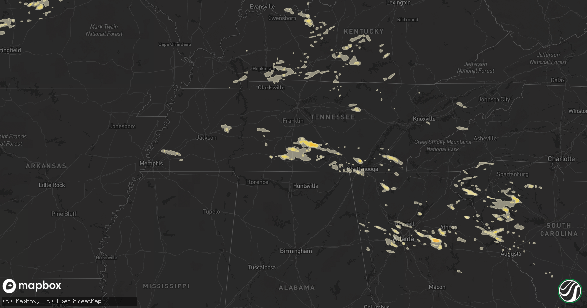
Hail Map in Missouri on June 18, 2011
Get this storm
June 18 map
$229
one time, instant access
Download today. No call, no setup
Keep the $229
Bought the map and want the full workflow? Apply the entire $229 to a subscription within 7 days. None of it is wasted.
Every map, not just this one
This buys you this map. Subscription and you get every map we run, in the markets you choose from a few cities to whole states to nationwide. Plus real-time alerts the moment a storm fires.
Contact data
Name, contact info, occupancy, even credit band for addresses in the footprint. You go from where it hit to who to call.
Become the source they trust
Unlimited branding weather history reports on demand. You already have the documented answer ready for the property owner, and you are the one who showed up with it.
Property data and RoofTrace estimates
Pull up any address you have got, its value and the exact code rules for that jurisdiction, straight from One Click Code. Then RoofTrace estimates the squares, pitch, and roof value, priced the way you price.
Storm reports in Missouri
Missouri
| Date | Description |
|---|---|
| 06/18/201111:50 AM CDT | A local report indicates 1.00 inch wind near BOWLING GREEN |
| 06/18/20117:28 AM CDT | Power lines down. |
| 06/18/20117:00 AM CDT | A local report indicates 1.00 inch wind near NEW HAMPTON |
| 06/18/20113:22 AM CDT | Power outages reported in portions of the community. |
| 06/18/20113:05 AM CDT | A few trees down on hwy 32 |
| 06/18/20113:00 AM CDT | Power lines down across the county |
| 06/18/20112:52 AM CDT | A local report indicates 60 MPH wind near FARMINGTON |
| 06/18/20112:50 AM CDT | Numerous trees uprooted or snapped...12 to 14 inches in diameter and up to 40 feet tall...on the south side of town. Time estimated. |
| 06/18/20112:35 AM CDT | Corrugated vinyl roof torn off a chicken coop. Chicken coop overturned. Several three to four inch diameter tree limbs down. |
| 06/18/20112:30 AM CDT | Tree limbs and power lines down |
| 06/18/20112:20 AM CDT | Tree limbs and powerlines down. Report relayed by fox2. Time estimated. |
| 06/18/20112:14 AM CDT | Tree limbs and power lines down near festus. Time estimated from radar. |
| 06/18/20112:05 AM CDT | Spotter reports significant damage to the upper floor of a 2 story house west of cherryville. Several other homes in the area sustained minor damage. Numerous trees and |
| 06/18/20112:05 AM CDT | Uprooted tree |
| 06/18/20112:05 AM CDT | Numerous 6 inch limbs broken out of trees. A couple of small trees snapped off near the ground. |
| 06/18/20112:05 AM CDT | Spotter reports significant damage to the upper floor of a 2 story house in cherryville. Numerous trees and power lines down. |
| 06/18/20112:00 AM CDT | Tree down across highway 19 north |
| 06/18/20112:00 AM CDT | Tree down and blocking higway 19. |
| 06/18/20112:00 AM CDT | Tree down across highway 68 just north of highway u |
| 06/18/20111:50 AM CDT | 18 to 30 inch diameter trees downed. Time estimated. |
| 06/18/20111:21 AM CDT | Tree down across highway 17. Already cleared. |
| 06/18/20111:15 AM CDT | All exposed car windshields cracked and/or broken. Numerous dings on vehicles from the hail. |
| 06/18/20111:06 AM CDT | A local report indicates 2.75 inch wind near 2 SE PLATTE CITY |
| 06/18/20111:04 AM CDT | Report via twitter |
| 06/18/20111:02 AM CDT | A local report indicates 1.75 inch wind near 2 SSE PLATTE CITY |
| 06/18/201112:55 AM CDT | Tree on a house in eldrige at hwy e and mohave dr. |
| 06/18/201112:55 AM CDT | A local report indicates 60 MPH wind near LEBANON |
| 06/18/201112:55 AM CDT | Hail lasted approximately 8 minutes. |
| 06/18/201112:45 AM CDT | Slightly larger than quarters |
| 06/18/201112:45 AM CDT | Trees and power lines down...estimated wind gust to 60 mph. |
| 06/18/201112:40 AM CDT | Power lines down across highway w between phillipsburg and lebanon |
| 06/18/201112:37 AM CDT | 63 mph gust measured at division and 65. Winds also estimated 60-65 mph at 104 mile marker on i-44. |
| 06/18/201112:35 AM CDT | Tree down and blocking grover road |
| 06/18/201112:30 AM CDT | Several limbs down. |
| 06/18/201112:15 AM CDT | Passed on by greene county oem. |
| 06/18/201112:15 AM CDT | Trees and powerlines down along farm road 35 |
| 06/18/201112:15 AM CDT | 63 mph gust measured at division and 65. Winds also estimated 60-65 mph at 104 mile marker on i-44. |
| 06/18/201112:15 AM CDT | Damage to roof of kum and go in fair grove. |
| 06/18/201112:12 AM CDT | A local report indicates 70 MPH wind near 2 SW BOLIVAR |
| 06/18/201112:12 AM CDT | A local report indicates 70 MPH wind near MORRISVILLE |
| 06/18/201112:07 AM CDT | A local report indicates 60 MPH wind near WALNUT GROVE |
| 06/18/201112:03 AM CDT | 60 to 70 mph wind gust estimated |
| 06/18/201112:03 AM CDT | Ground survey confirmed an ef-0 tornado produced 70 to 80 mph winds along an east southeast path between three miles southeast of brighton...just north of the greene co |
| 06/18/201112:00 AM CDT | Barn destroyed...shingles off of a roof...and 6-8 inch tree limbs reported down along greene county farm roads 2 and 6. Reported by polk county ema. |
| 06/17/201111:52 PM CDT | A local report indicates 1.75 inch wind near HENRIETTA |
| 06/17/201111:47 PM CDT | Deputies reported golf ball size hail in bowling green |
| 06/17/201111:45 PM CDT | A local report indicates 1.50 inch wind near BOWLING GREEN |
| 06/17/201111:41 PM CDT | Numerous trees down across central and eastern portions of dade county. |
| 06/17/201111:40 PM CDT | A nws survey team determined that an ef-1 tornado with estimated winds of 80-90 mph occurred on june 18th. The storm touched down around 1140 pm about 2 miles southeast |
| 06/17/201111:35 PM CDT | A nws survey team determined that an ef-1 tornado with winds of 80-90 mph occurred on june 18th. The tornado touched down around 1135 pm about 4 miles northeast of ever |
| 06/17/201111:35 PM CDT | Power lines down |
| 06/17/201111:34 PM CDT | Pea to quarter sized hail reported |
| 06/17/201111:30 PM CDT | A local report indicates 60 MPH wind near GREENFIELD |
| 06/17/201111:24 PM CDT | Home weather station measured wind gust of 83 mph |
| 06/17/201111:24 PM CDT | Tin roof off of a business |
| 06/17/201111:20 PM CDT | Along with pea sized hail |
| 06/17/201111:11 PM CDT | Trees down in purcell |
| 06/17/201111:01 PM CDT | A local report indicates 1.75 inch wind near 1 WNW BLUE SPRINGS |
| 06/17/201110:50 PM CDT | Grain bin destroyed...wind gust estimated at 80 mph. |
| 06/17/201110:40 PM CDT | A local report indicates 1.00 inch wind near 1 E LONE JACK |
| 06/17/201110:31 PM CDT | A local report indicates 1.00 inch wind near 1 E LONE JACK |
| 06/17/201110:30 PM CDT | 5 inch tree branches down |
| 06/17/201110:16 PM CDT | A local report indicates 1.50 inch wind near 3 SE GARDEN CITY |
| 06/17/201110:00 PM CDT | A local report indicates 1.75 inch wind near 5 S PLEASANT HILL |
| 06/17/20119:55 PM CDT | A local report indicates 1.00 inch wind near NW HARRISONVILLE |
| 06/17/20119:45 PM CDT | Photos sent into nws via local media |
| 06/17/20119:42 PM CDT | A local report indicates 1.00 inch wind near PECULIAR |
| 06/17/20119:42 PM CDT | A local report indicates 1.50 inch wind near HARRISONVILLE |
| 06/17/20119:40 PM CDT | A local report indicates 1.00 inch wind near 1 W CREIGHTON |
| 06/17/20119:35 PM CDT | A local report indicates 1.00 inch wind near 3 SE GARDEN CITY |
| 06/17/20119:33 PM CDT | Nickle to one half dollar size hail along western city limits of jefferson city |
| 06/17/20119:30 PM CDT | Quarter size hail on west side of jefferson city. |
| 06/17/20119:25 PM CDT | Northwest side of jefferson city. |
| 06/17/20119:22 PM CDT | Quarter to golfball size hail beginning to cover the ground in westview heights area. |
| 06/17/20119:21 PM CDT | A local report indicates 1.00 inch wind near ST. MARTINS |
| 06/17/20119:20 PM CDT | One half dollar size hail 2.5 miles west of jefferson city |
| 06/17/20119:07 PM CDT | Deputy sheriff 2 miles south of jefferson city reported golfball size hail |
| 06/17/20119:03 PM CDT | A local report indicates 1.75 inch wind near WINDSOR |
| 06/17/20119:00 PM CDT | A local report indicates 1.75 inch wind near WINDSOR |
| 06/17/20118:53 PM CDT | A local report indicates 1.75 inch wind near 2 ENE ARCHIE |
| 06/17/20118:35 PM CDT | A local report indicates 1.75 inch wind near LAKELAND |
| 06/17/20118:35 PM CDT | A local report indicates 1.25 inch wind near CALHOUN |
| 06/17/20118:35 PM CDT | Relayed by krcg tv |
All States Impacted by Hail Map on June 18, 2011
Cities Impacted by Hail Map on June 18, 2011
- Bowman, GA
- Dewy Rose, GA
- Elberton, GA
- Jetmore, KS
- Cimarron, KS
- Blackwell, TX
- Merkel, TX
- Nolan, TX
- Cornersville, TN
- Pulaski, TN
- Valley Center, KS
- Augusta, ME
- South China, ME
- Windsor, ME
- Vassalboro, ME
- Viroqua, WI
- Underhill, VT
- Ashland, MO
- New Bloomfield, MO
- Hartsburg, MO
- Fair Play, MO
- Independence, KS
- Nocona, TX
- Jacksboro, TX
- Bridgeport, TX
- Perrin, TX
- Alvord, TX
- Chico, TX
- Smithwick, SD
- Oelrichs, SD
- Pine Ridge, SD
- Unionville, TN
- Chapel Hill, TN
- Shelbyville, TN
- Normandy, TN
- Wartrace, TN
- Lewisburg, TN
- Ninety Six, SC
- Sulphur, OK
- Graford, TX
- Gainesville, TX
- Thackerville, OK
- Rayville, MO
- Polo, MO
- Knob Noster, MO
- Milan, GA
- Rhine, GA
- Kit Carson, CO
- Marietta, IL
- Macomb, IL
- Adair, IL
- Kissimmee, FL
- Orlando, FL
- Oviedo, FL
- Hugo, CO
- Chatsworth, GA
- Dalton, GA
- Kinsley, KS
- Kansas City, MO
- Wilcox, NE
- Hildreth, NE
- Upland, NE
- Sedan, KS
- Pawhuska, OK
- Cedar Vale, KS
- Lindsay, TX
- Booneville, AR
- Turon, KS
- McCormick, SC
- Lincolnton, GA
- Bradley, SC
- Greenwood, SC
- Dexter, KS
- Maple City, KS
- Bellevue, TX
- Welch, OK
- Vinita, OK
- Delaware, OK
- Winterville, GA
- Colbert, GA
- Arnoldsville, GA
- Pittsfield, IL
- Winchester, IL
- Funk, NE
- Selden, KS
- Charleston, AR
- Branch, AR
- Olathe, KS
- Toronto, KS
- Moore Haven, FL
- Union, SC
- Petersburg, TN
- Cedartown, GA
- Atoka, TN
- Arlington, TN
- Millington, TN
- Jamestown, TN
- Smithville, MO
- Grain Valley, MO
- Lees Summit, MO
- Blue Springs, MO
- Delano, TN
- Reliance, TN
- Charleston, TN
- Cleveland, TN
- Benton, TN
- Calhoun, TN
- Tuscola, TX
- Clinton, SC
- Joanna, SC
- Laurens, SC
- Kinards, SC
- Green Ridge, MO
- Concordia, MO
- Sweet Springs, MO
- Loomis, NE
- Alexander, IL
- Ashland, IL
- Pleasant Plains, IL
- New Berlin, IL
- Plant City, FL
- La Grange, MO
- Canton, MO
- Ewing, MO
- Lewistown, MO
- Monticello, MO
- Lakin, KS
- Leoti, KS
- English, IN
- Marengo, IN
- Paoli, IN
- French Lick, IN
- Murrayville, IL
- Roodhouse, IL
- Dighton, KS
- Scott City, KS
- Healy, KS
- Glennville, GA
- Centerville, TN
- Duck River, TN
- Paris, MO
- Neodesha, KS
- Elk City, KS
- Cherryvale, KS
- Strong City, KS
- Emporia, KS
- Council Grove, KS
- Cottonwood Falls, KS
- Lithia, FL
- Cookeville, TN
- Sparta, TN
- Monterey, TN
- Breckenridge, TX
- Ranger, TX
- Macon, MO
- Huntsville, MO
- Jacksonville, MO
- Moberly, MO
- Cairo, MO
- Excello, MO
- Clifton Hill, MO
- Madison, MO
- Curtis, NE
- Enosburg Falls, VT
- Richford, VT
- Ness City, KS
- McCune, KS
- New Vineyard, ME
- Farmington, ME
- Anson, ME
- New Portland, ME
- Garden City, MO
- Creighton, MO
- Gardiner, ME
- Randolph, ME
- Mount Vernon, ME
- Whitefield, ME
- Hallowell, ME
- Readfield, ME
- Kents Hill, ME
- Manchester, ME
- Farmingdale, ME
- Winthrop, ME
- Saint Paul, KS
- Savannah, GA
- Magazine, AR
- Pearl, IL
- Milton, IL
- Bismarck, ND
- Mandan, ND
- Springer, OK
- Ardmore, OK
- Gravois Mills, MO
- Freeburg, MO
- Russellville, MO
- Argyle, MO
- Holts Summit, MO
- Belle, MO
- Eugene, MO
- Jefferson City, MO
- Olean, MO
- Centertown, MO
- Owensville, MO
- Leslie, MO
- Hermann, MO
- Rosebud, MO
- Kaiser, MO
- Henley, MO
- California, MO
- Lake Ozark, MO
- Westphalia, MO
- New Haven, MO
- Osage Beach, MO
- Saint Thomas, MO
- Saint Elizabeth, MO
- Bonnots Mill, MO
- Meta, MO
- Eldon, MO
- Lohman, MO
- Linn, MO
- Gerald, MO
- Rocky Mount, MO
- Bland, MO
- Koeltztown, MO
- Fulton, MO
- Tuscumbia, MO
- Loose Creek, MO
- Inavale, NE
- Forest Park, GA
- Atlanta, GA
- South Portland, ME
- Portland, ME
- Cape Elizabeth, ME
- Gorham, ME
- Westbrook, ME
- Scarborough, ME
- Henrietta, MO
- Napoleon, MO
- Bates City, MO
- Camden, MO
- Lexington, MO
- Odessa, MO
- Wellington, MO
- Butler, MO
- Bolivar, MO
- Ridgeway, MO
- Eagleville, MO
- Petersburg, WV
- Old Fields, WV
- Lahmansville, WV
- El Dorado, KS
- Augusta, KS
- Towanda, KS
- Platte City, MO
- Saint Cloud, FL
- Fall Creek, WI
- Belton, SC
- Saint Francis, SD
- Stowe, VT
- Erie, KS
- Hardyville, KY
- Canmer, KY
- Greensburg, KY
- Welch, MN
- Frankewing, TN
- Pelham, TN
- Lawrenceburg, TN
- Tullahoma, TN
- Hillsboro, TN
- Manchester, TN
- Estill Springs, TN
- Culleoka, TN
- Tracy City, TN
- Belfast, TN
- Ethridge, TN
- Mulberry, TN
- Monteagle, TN
- Lynnville, TN
- Fayetteville, TN
- Woodman, WI
- Mount Hope, WI
- Central, SC
- Makoti, ND
- Ryder, ND
- Burlingame, KS
- Clearwater, KS
- Benton, KS
- Mondovi, WI
- Ridgeway, IA
- Decorah, IA
- Cresco, IA
- Cannon Falls, MN
- Spearville, KS
- Offerle, KS
- Red Wing, MN
- Lake City, MN
- Frontenac, MN
- Ulmer, SC
- Haubstadt, IN
- Elberfeld, IN
- Evansville, IN
- Halliday, ND
- Florence, KS
- Cedar Point, KS
- Rutledge, GA
- Madison, GA
- Mill Creek, OK
- Flintstone, GA
- Rossville, GA
- Lawrence, KS
- Isabel, SD
- S Coffeyville, OK
- Wann, OK
- Coffeyville, KS
- Signal Mountain, TN
- Pleasant Hill, IL
- Vandalia, MO
- Louisiana, MO
- Clarksville, MO
- Middletown, MO
- Bowling Green, MO
- Curryville, MO
- Wellsville, MO
- Hager City, WI
- Ellsworth, WI
- New Gloucester, ME
- Auburn, ME
- Poland, ME
- Falls Of Rough, KY
- Hardinsburg, KY
- Nelson, WI
- Saint Jo, TX
- Muenster, TX
- Plum Branch, SC
- Modoc, SC
- Burneyville, OK
- Leon, OK
- Whitesboro, TX
- Marietta, OK
- Montague, TX
- Overton, NE
- Elm Creek, NE
- Lexington, NE
- Axtell, NE
- Eddyville, NE
- Summer Shade, KY
- Leonard, MO
- Warsaw, IL
- Shelbyville, MO
- Durham, MO
- La Belle, MO
- Bethel, MO
- Mendon, IL
- Ursa, IL
- Quincy, IL
- Newark, MO
- Windsor, MO
- Loganville, GA
- Wilson, OK
- Garden City, KS
- Snellville, GA
- Lilburn, GA
- Leitchfield, KY
- Arkansas City, KS
- South Haven, KS
- Newkirk, OK
- Oxford, KS
- Copan, OK
- Liberty, KS
- Shidler, OK
- Geuda Springs, KS
- Caney, KS
- Winfield, KS
- Ocklawaha, FL
- Weirsdale, FL
- Belleview, FL
- Burlington, KS
- Hartford, KS
- Marienthal, KS
- Leon, KS
- Girard, KS
- Ingalls, KS
- Tompkinsville, KY
- Fountain Run, KY
- Gamaliel, KY
- Kanorado, KS
- Goodland, KS
- Hamilton, KS
- Glendale, KY
- White Mills, KY
- Eastview, KY
- Cecilia, KY
- Cleveland, MO
- Independence, MO
- Freeman, MO
- Harrisonville, MO
- Pleasant Hill, MO
- Oak Grove, MO
- Belton, MO
- Raymore, MO
- Adrian, MO
- Lone Jack, MO
- Buckner, MO
- Kingsville, MO
- Orrick, MO
- Drexel, MO
- Archie, MO
- Greenwood, MO
- Urich, MO
- Levasy, MO
- East Lynne, MO
- Sibley, MO
- Peculiar, MO
- Blairstown, MO
- Bucyrus, KS
- Kansas City, KS
- Strawn, TX
- Graham, TX
- Rockport, IN
- Kenyon, MN
- North Augusta, SC
- Montrose, IA
- Argyle, IA
- Keokuk, IA
- Wayland, MO
- Kahoka, MO
- Edina, MO
- Liberty, KY
- Red Boiling Springs, TN
- Brumley, MO
- Iberia, MO
- Ulman, MO
- Lebanon, MO
- Castalia, IA
- Ossian, IA
- Owensville, IN
- Wichita, KS
- Bowen, IL
- West Point, IL
- Loraine, IL
- Golden, IL
- Linn Creek, MO
- Mapleton, KS
- Franklin, IL
- Nebo, IL
- Lockwood, MO
- Bridgeport, AL
- South Pittsburg, TN
- Arapahoe, CO
- Cheyenne Wells, CO
- Carson, ND
- Elgin, ND
- Almont, ND
- Mason, TN
- Henrietta, TX
- Overbrook, KS
- Newton, KS
- Fairfax, VT
- Westford, VT
- Milton, VT
- Campbell, NE
- Holstein, NE
- Holdrege, NE
- Bladen, NE
- Naponee, NE
- Minden, NE
- Franklin, NE
- Atlanta, NE
- Riverton, NE
- Bloomington, NE
- Jacksonville, IL
- Appleton City, MO
- New Salem, ND
- Eastaboga, AL
- Lincoln, AL
- Latham, KS
- Atlanta, KS
- Bertrand, NE
- Lewis, KS
- Belpre, KS
- Bishop, GA
- Watkinsville, GA
- Bogart, GA
- Good Hope, GA
- Statham, GA
- Monroe, GA
- Sedgwick, KS
- Whitewater, KS
- Derby, KS
- Stephens, GA
- Crawford, GA
- Arthur, NE
- Lemoyne, NE
- Lewellen, NE
- Rutledge, MO
- Louisburg, MO
- Fredonia, KS
- Vero Beach, FL
- Half Way, MO
- Oral, SD
- Pine Bluffs, WY
- Bushnell, NE
- Blythedale, MO
- Altamont, TN
- Chappell, NE
- Bushnell, FL
- Burns, KS
- Norborne, MO
- Carrollton, MO
- Bogard, MO
- Osage City, KS
- Social Circle, GA
- Timber Lake, SD
- Eagle Butte, SD
- Dupree, SD
- Daytona Beach, FL
- Milltown, IN
- Depauw, IN
- Lawrenceville, IL
- Brookfield, MO
- Ferdinand, IN
- Camdenton, MO
- Sheridan Lake, CO
- Lamar, MO
- Golden City, MO
- Allen, KS
- Eskridge, KS
- Union City, GA
- Gridley, KS
- Eckerty, IN
- Birdseye, IN
- Iuka, KS
- Petersburg, IN
- Stockholm, WI
- Whitleyville, TN
- Pleasant Shade, TN
- Sunrise Beach, MO
- Montreal, MO
- Stoutland, MO
- Mount Sterling, MO
- Chamois, MO
- Richland, MO
- Crocker, MO
- Kingdom City, MO
- Udall, KS
- Moran, TX
- Burns, WY
- Deerfield, KS
- Edmonton, KY
- Marietta, GA
- Vincennes, IN
- Decker, IN
- Union Mills, NC
- Ocala, FL
- Osteen, FL
- New Smyrna Beach, FL
- Moorefield, NE
- Farnam, NE
- Fairburn, GA
- Douglasville, GA
- Winston, GA
- Abilene, TX
- Winona, KS
- Vona, CO
- Zumbro Falls, MN
- Millville, MN
- Norway, ME
- Mechanic Falls, ME
- Waterford, ME
- Oxford, ME
- Greenwood, ME
- Buffalo, MO
- Windyville, MO
- Commerce, GA
- Royston, GA
- Carnesville, GA
- Holcomb, KS
- Wright, KS
- Dodge City, KS
- Hanston, KS
- Smyrna, GA
- Andover, KS
- Palmetto, GA
- Sharpsburg, GA
- Newnan, GA
- Tyrone, GA
- Martinsville, MO
- Beulah, ND
- Glen Ullin, ND
- Hebron, ND
- Rose Hill, KS
- Douglass, KS
- Mulvane, KS
- McLaughlin, SD
- Chattanooga, TN
- Whitwell, TN
- Ringgold, TX
- Kennesaw, GA
- Waldron, MO
- Burden, KS
- Guthrie, KY
- Evans, GA
- Augusta, GA
- Mount Carmel, SC
- Saint Meinrad, IN
- Evanston, IN
- Eustis, NE
- Pickens, SC
- Grover, CO
- Breeding, KY
- Columbia, KY
- Parsons, KS
- Calhoun, MO
- Sequatchie, TN
- Decatur, TN
- Vienna, MO
- Lakeland, FL
- Fulton, KS
- Greenfield, MO
- Jasper, MO
- Ramah, CO
- Trenton, GA
- Jasper, TN
- Guild, TN
- Bristow, IN
- Cleveland, SC
- Marietta, SC
- Caneyville, KY
- Dadeville, MO
- Broadwater, NE
- Norwood, GA
- Thomson, GA
- Hayesville, NC
- Murphy, NC
- Haysville, KS
- Mcconnell Afb, KS
- Stratton, CO
- Ellabell, GA
- Pembroke, GA
- Gilliam, MO
- Durand, WI
- Athens, GA
- Clarkson, KY
- New Sharon, ME
- Wyaconda, MO
- Brashear, MO
- Baring, MO
- Gorin, MO
- Knox City, MO
- Hurdland, MO
- Waterloo, SC
- Hodges, SC
- Burkesville, KY
- Gradyville, KY
- Scranton, KS
- Port Orange, FL
- Due West, SC
- Cross Hill, SC
- Ware Shoals, SC
- Honea Path, SC
- Donalds, SC
- Gray Court, SC
- Mountville, SC
- Wilton, ME
- Vienna, ME
- Parshall, ND
- Fort Stewart, GA
- Lyman, NE
- Asbury, MO
- Deltona, FL
- Cisco, TX
- Tribune, KS
- Gove, KS
- Franklin, KY
- Auburn, KY
- Umatilla, FL
- Summerfield, FL
- Lady Lake, FL
- Maiden Rock, WI
- Plum City, WI
- Arkansaw, WI
- Millwood, KY
- Belgrade, ME
- Williston, FL
- Pelzer, SC
- Williamston, SC
- Arcadia, KS
- Cannelton, IN
- Leavenworth, IN
- Central, IN
- Battletown, KY
- Leopold, IN
- Mauckport, IN
- Corydon, IN
- Branchville, IN
- Riceville, TN
- Standish, ME
- Stewartville, MN
- Grand Meadow, MN
- Racine, MN
- Cozad, NE
- Mountain Rest, SC
- Walhalla, SC
- Oakland, ME
- Selfridge, ND
- McIntosh, SD
- Oshkosh, NE
- Kasson, MN
- Deer Trail, CO
- Flat Rock, IL
- Allensville, KY
- Abbeville, SC
- Roebuck, SC
- Woodruff, SC
- Fall River, KS
- Longton, KS
- Howard, KS
- Scammon, KS
- Warrensburg, MO
- Leeton, MO
- Stoutsville, MO
- Monroe City, MO
- Clarence, MO
- Clewiston, FL
- Richardton, ND
- Hazen, ND
- Ionia, MO
- Clinton, MO
- Sedalia, MO
- Cole Camp, MO
- Lincoln, MO
- Wildwood, GA
- Lookout Mountain, GA
- Auburndale, FL
- Travelers Rest, SC
- Brevard, NC
- Pisgah Forest, NC
- Landrum, SC
- Cedar Mountain, NC
- Cameron, OK
- Agate, CO
- Conyers, GA
- Lithonia, GA
- Trenton, SC
- Caddo, TX
- Bay City, WI
- Cadiz, KY
- Richmond Hill, GA
- Midway, GA
- Fleming, GA
- Pepin, WI
- Blountsville, AL
- Cleveland, AL
- Oneonta, AL
- Weir, KS
- Opolis, KS
- Cherokee, KS
- Galesburg, KS
- Elk Falls, KS
- Piedmont, KS
- Pittsburg, KS
- Columbus, KS
- Oswego, KS
- Dennis, KS
- Mindenmines, MO
- Moline, KS
- Thayer, KS
- Arcola, MO
- Walnut, KS
- Grenola, KS
- West Mineral, KS
- Liberal, MO
- Mound Valley, KS
- Oronogo, MO
- Ellijay, GA
- Graniteville, SC
- Aiken, SC
- Bonner Springs, KS
- Smithfield, NE
- Elwood, NE
- Cave City, KY
- Manchester, IA
- Peabody, KS
- Horse Cave, KY
- Edgefield, SC
- Wingate, TX
- Brady, NE
- Gothenburg, NE
- Mount Hermon, KY
- Sutherland, NE
- Tryon, NE
- Fruitland Park, FL
- Olar, SC
- Ehrhardt, SC
- Elizabethtown, KY
- Iva, SC
- Paisley, FL
- Lisco, NE
- Hixson, TN
- Windsor, KY
- Wildersville, TN
- Yuma, TN
- Lexington, TN
- Cedar Grove, TN
- Altoona, KS
- Stockton, MO
- Carthage, MO
- Galena, KS
- Frontenac, KS
- Morrisville, MO
- Brighton, MO
- Polk, MO
- South Greenfield, MO
- Benedict, KS
- Aldrich, MO
- Carl Junction, MO
- Flemington, MO
- Walnut Grove, MO
- Viola, KS
- Webb City, MO
- Everton, MO
- Jerico Springs, MO
- Peck, KS
- Mendon, MO
- Franklin, VT
- Montgomery Center, VT
- Cloverport, KY
- Harned, KY
- McDaniels, KY
- Westview, KY
- Hawesville, KY
- Murrayville, GA
- Beeler, KS
- Walton, KS
- Bloomingdale, GA
- Pooler, GA
- Dixon, MO
- Nauvoo, IL
- Claxton, GA
- Elkton, KY
- Dawn, MO
- Wedowee, AL
- Woodland, AL
- Delta, AL
- Carbondale, KS
- Reading, KS
- Harveyville, KS
- Berryton, KS
- Burlington, ND
- Milledgeville, GA
- Sparta, GA
- Bristol, VT
- Starksboro, VT
- Cumming, GA
- Somerville, TN
- Oakland, TN
- Brighton, TN
- Murray, KY
- Montrose, IL
- Decatur, TX
- Montgomery, IN
- Otwell, IN
- Jasper, IN
- Winchester, TN
- Sewanee, TN
- Belvidere, TN
- Sherwood, TN
- Martinsburg, MO
- Hardin, MO
- Ash Grove, MO
- Bowling Green, KY
- Carlsbad, TX
- Morrisonville, IL
- Matfield Green, KS
- Cassoday, KS
- Eureka, KS
- Centralia, MO
- Clark, MO
- Fountain Inn, SC
- Campbellsville, KY
- Olmstead, KY
- Rex, GA
- Jonesboro, GA
- Stockbridge, GA
- Morrow, GA
- Wauzeka, WI
- Summertown, TN
- Hohenwald, TN
- Bethlehem, GA
- Mexico, MO
- Table Grove, IL
- Smithfield, IL
- Industry, IL
- Powder Springs, GA
- Mableton, GA
- Austell, GA
- Greenwood, AR
- Huntington, AR
- Elmdale, KS
- Riverside, MO
- Dunlap, TN
- Gardner, KS
- Greenville, KY
- Macksville, KS
- Big Clifty, KY
- Dallas, GA
- Rockmart, GA
- Saluda, SC
- Johnston, SC
- Ward, SC
- Osceola, AR
- Scottsville, KY
- Alvaton, KY
- Austin, KY
- Bucklin, MO
- McRae Helena, GA
- Lumber City, GA
- Jacksonville, GA
- Rayle, GA
- Union Point, GA
- Carlisle, SC
- Chester, SC
- Lake Placid, FL
- Lorida, FL
- Minot, ME
- Seneca, SC
- Anderson, SC
- Townville, SC
- Mansfield, GA
- Holland, IN
- Huntingburg, IN
- Sharon Grove, KY
- Lewisburg, KY
- White, GA
- Rydal, GA
- Westminster, SC
- Russellville, KY
- Mims, FL
- El Dorado Springs, MO
- Burlington, CO
- Elma, IA
- Alta Vista, IA
- Custer, KY
- Garfield, KY
- Columbia, MO
- Rockfield, KY
- Woodburn, KY
- Lyndon, KS
- Wagener, SC
- St John, KS
- Monroe City, IN
- Rock, KS
- Gainesville, GA
- Dawsonville, GA
- Dover, TN
- Oakley, KS
- Christmas, FL
- Utica, KS
- Kearney, NE
- Paola, KS
- Louisburg, KS
- Edson, KS
- Elk Horn, KY
- Oak Hill, FL
- Hiram, GA
- Bronte, TX
- Onalaska, WI
- La Crosse, WI
- Rockport, IL
- Glenburn, ND
- Fort Scott, KS
- Garland, KS
- Nancy, KY
- Calhoun Falls, SC
- Madison, KS
- Kirksville, MO
- Macks Creek, MO
- Roach, MO
- Hopkinsville, KY
- Levant, KS
- Stearns, KY
- Monticello, KY
- Pittsford, VT
- Brandon, VT
- Florence, VT
- North Platte, NE
- Boonville, IN
- Yates Center, KS
- Saint Francisville, IL
- Windham, ME
- Climax Springs, MO
- Barnwell, SC
- Eudora, KS
- Edgerton, KS
- Baldwin City, KS
- Sarasota, FL
- Myakka City, FL
- Morgantown, KY
- Lafayette, TN
- Harwood, MO
- Schell City, MO
- Montrose, MO
- Buford, GA
- Flowery Branch, GA
- Robinson, IL
- Oblong, IL
- Roundhill, KY
- Lynchburg, TN
- Dix, NE
- Potter, NE
- Weston, MO
- Hackett, AR
- Brinktown, MO
- Gurley, NE
- Sidney, NE
- Roswell, GA
- Sanford, FL
- Geneva, FL
- Ormond Beach, FL
- Ridgeland, SC
- Hastings, MN
- Hartford, TN
- Hot Springs, NC
- Nerstrand, MN
- Hazlehurst, GA
- Denton, GA
- Tybee Island, GA
- Postville, IA
- Ochopee, FL
- Brewster, KS
- Dixon Springs, TN
- Harrisburg, MO
- Virgil, KS
- Buffalo, KS
- Severy, KS
- Rochester, MN
- Eyota, MN
- Stone Mountain, GA
- Lewisport, KY
- Sherman, TX
- Copperhill, TN
- Moorefield, WV
- Fisher, WV
- Lawrenceville, GA
- Grayson, GA
- Glasgow, KY
- La Follette, TN
- Norridgewock, ME
- Healdton, OK
- Lone Grove, OK
- Bluejacket, OK
- Chanute, KS
- Bloomington Springs, TN
- Baxter, TN
- Holden, MO
- Hawk Springs, WY
- Etoile, KY
- Frostproof, FL
- Colby, KS
- Mission, SD
- Greeley, KS
- Garnett, KS
- Pendleton, SC
- Dalton, MO
- Keytesville, MO
- Marion, NC
- Mansfield, AR
- Paris, AR
- Fayette, MO
- West Union, SC
- Kiowa, CO
- Le Roy, KS
- Stilwell, KS
- Tell City, IN
- Midway, TN
- Mosheim, TN
- Bowling Green, FL
- Forestburg, TX
- Enoree, SC
- Punta Gorda, FL
- Salisbury, MO
- Watauga, SD
- Cynthiana, IN
- Poseyville, IN
- Elk Mound, WI
- Eau Claire, WI
- Harvel, IL
- Dade City, FL
- Webster, FL
- Minot, ND
- North Fort Myers, FL
- Richmond, MO
- Baldwin, ND
- Whitesburg, TN
- Russellville, TN
- Mohawk, TN
- Bulls Gap, TN
- Lithia Springs, GA
- Lebo, KS
- Melvern, KS
- Waverly, KS
- Lancing, TN
- Georgetown, TN
- Brownsville, KY
- Reidsville, GA
- Virginia, IL
- Appling, GA
- Monument, KS
- Broxton, GA
- Ridge Spring, SC
- Strong, ME
- Lawson, MO
- Plymouth, IL
- La Crescent, MN
- Wellfleet, NE
- Oak Grove, KY
- Pembroke, KY
- Medford, OK
- Palm Coast, FL
- Grandview, IN
- Maceo, KY
- Edgewater, FL
- Baxter Springs, KS
- Allenhurst, GA
- Beersheba Springs, TN
- Allendale, IL
- Ooltewah, TN
- Eldridge, MO
- Bethany, MO
- New Hampton, MO
- Niotaze, KS
- Dearing, KS
- Edna, KS
- Lenapah, OK
- Tyro, KS
- Farley, MO
- Cowgill, MO
- Oxford, GA
- Covington, GA
- Dallas City, IL
- Niota, IL
- Trenton, KY
- Clarksville, TN
- Higbee, MO
- Bison, KS
- Grinnell, KS
- Harpersville, AL
- Stendal, IN
- Elkton, FL
- Hastings, FL
- Williston, TN
- Limon, CO
- Saint Patrick, MO
- Washington, GA
- Cherokee, NC
- Cosby, TN
- Clyde, NC
- Frederick, IL
- Basehor, KS
- Tonganoxie, KS
- Sonora, KY
- Durham, ME
- Bethel, ME
- South Paris, ME
- Knob Lick, KY
- Center, KY
- Triplett, MO
- Robert Lee, TX
- Plainview, MN
- Resaca, GA
- Leesburg, AL
- Port Wentworth, GA
- Woodrow, CO
- Lebanon, KY
- Bradfordsville, KY
- Chandler, IN
- Derby, IN
- Union Star, KY
- Lena, IL
- Gays Mills, WI
- Steuben, WI
- Auxvasse, MO
- Chappells, SC
- Warsaw, MO
- Lodge, SC
- Braymer, MO
- Ringgold, GA
- Marshall, MO
- Bryant, AL
- Morganton, GA
- Hudson, KY
- Sheldon, MO
- Brooksville, FL
- Epworth, GA
- Blue Ridge, GA
- Old Fort, TN
- Hilton Head Island, SC
- Sunset, SC
- Six Mile, SC
- Salem, SC
- Tamassee, SC
- Knoxville, TN
- Seymour, TN
- Fort Oglethorpe, GA
- Lookout Mountain, TN
- Chickamauga, GA
- Hardinsburg, IN
- Calhan, CO
- Rushville, IL
- Ludowici, GA
- Byron, MN
- Lamar, IN
- Chrisney, IN
- Clarks Hill, SC
- Tignall, GA
- Hazel, KY
- Science Hill, KY
- Benton City, MO
- Mulberry, FL
- Acworth, GA
- Woodstock, GA
- Peachtree Corners, GA
- Norcross, GA
- Duluth, GA
- Alpharetta, GA
- Northfield, MN
- Randolph, MN
- Farmington, MN
- Hillsboro, KS
- Spring Hill, KS
- Uniontown, KS
- Redfield, KS
- Summersville, KY
- Williamsburg, MO
- Miami, OK
- Blue Hill, NE
- Oxford, AL
- Munford, AL
- Princeton, KY
- Higginsville, MO
- Lavonia, GA
- Martin, GA
- Arriba, CO
- Flagler, CO
- Winter Springs, FL
- Flasher, ND
- Winslow, IN
- Riceboro, GA
- Carrollton, GA
- Bowdon, GA
- Buchanan, GA


