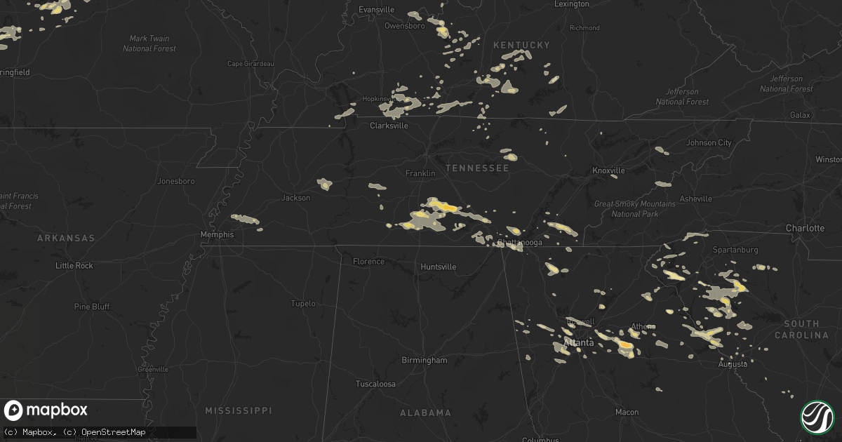
Hail Map in South Carolina on June 18, 2011
Get this storm
June 18 map
$229
one time, instant access
Download today. No call, no setup
Keep the $229
Bought the map and want the full workflow? Apply the entire $229 to a subscription within 7 days. None of it is wasted.
Every map, not just this one
This buys you this map. Subscription and you get every map we run, in the markets you choose from a few cities to whole states to nationwide. Plus real-time alerts the moment a storm fires.
Contact data
Name, contact info, occupancy, even credit band for addresses in the footprint. You go from where it hit to who to call.
Become the source they trust
Unlimited branding weather history reports on demand. You already have the documented answer ready for the property owner, and you are the one who showed up with it.
Property data and RoofTrace estimates
Pull up any address you have got, its value and the exact code rules for that jurisdiction, straight from One Click Code. Then RoofTrace estimates the squares, pitch, and roof value, priced the way you price.
Storm reports in South Carolina
South Carolina
| Date | Description |
|---|---|
| 06/18/20116:20 PM CDT | Report of tree down on lanneiu snipes rd near sc 41. Time of event estimated by radar. |
| 06/18/20116:15 PM CDT | Tree in roadway near us 76 and brick mill rd |
| 06/18/20115:53 PM CDT | Tree in roadway...near i-85 mm 11 |
| 06/18/20115:45 PM CDT | Powerlines in road...hw-187 and fisher jenkins rd. |
| 06/18/20115:30 PM CDT | Couple trees down along hwy 67 near callison. |
| 06/18/20115:26 PM CDT | Trees down near us highway 76 and hiller rd. |
| 06/18/20115:25 PM CDT | Em reported trees down in cheraw on laney and old cash roads. |
| 06/18/20115:24 PM CDT | Trees down near morningside drive and beatty rd in west columbia. |
| 06/18/20115:20 PM CDT | Sc hwy patrol reports tree in road near intersection of seagull lane and osprey point at lake murray |
| 06/18/20115:20 PM CDT | Several trees down along hwy 702 east of ninety six. |
| 06/18/20115:19 PM CDT | Kbbp asos reported gust of 58 mph. |
| 06/18/20115:18 PM CDT | Report of tree down on sc 9. Time of event estimated by radar. |
| 06/18/20115:17 PM CDT | Tree down on east old camden rd near sister sister. |
| 06/18/20115:17 PM CDT | Reported tree down on new hopewell rd. Time of event estimated by radar. |
| 06/18/20115:16 PM CDT | Tree down on east old camden rd near sister sister. Event time estimated by radar. |
| 06/18/20115:16 PM CDT | Tree down near intersection of s fifth street and patrick hwy. Time of event estimated by radar. |
| 06/18/20115:16 PM CDT | Reported tree down on bethlehem rd between us hwy 15 and byrdtown rd. Time of event estimated by radar. |
| 06/18/20114:58 PM CDT | Sherriff office reports trees down on brocks mill road. Time estimated by radar. |
| 06/18/20114:30 PM CDT | Tree in roadway along us 25 |
| 06/18/20114:21 PM CDT | Sc hwy patrol reports tree in roadway near sc hwy 56 and brehmer road. |
| 06/18/20114:18 PM CDT | Tree in roadway along sam hodges and morgan rds |
| 06/18/20114:15 PM CDT | Sherriffs dispatch reports numerous trees down countywide including the city of newberry. |
| 06/18/20113:55 PM CDT | Awos at lancaster county mcwhirter field airport observed a wind gust of 50 knots..or 58 mph. |
| 06/18/20113:53 PM CDT | Tree in roadway near young rd and us 76. |
| 06/18/20113:50 PM CDT | Media reported several trees and large limbs down on york st. |
| 06/18/20113:45 PM CDT | County sherriff reports numerous trees and powerlines down between hwy 5 south to the city of lancaster |
| 06/18/20113:44 PM CDT | Tree in road...simpson rd and harmony church rd. |
| 06/18/20113:38 PM CDT | Highway patrol reports a tree down on highway 308 just north of the city...with another tree on young rd 3 se of town. |
| 06/18/20113:38 PM CDT | Tree in roadway along hw-308 |
| 06/18/20113:30 PM CDT | Ham radio operator reported power lines down on dawson dr. Other power lines are down in the western part of the county. |
| 06/18/20113:21 PM CDT | Tree in roadway near ora rd and us 221 |
| 06/18/20113:15 PM CDT | Ice cube size hail on coneross creek rd- between quarter and golf ball size. |
| 06/18/20113:02 PM CDT | Spotter reports large limbs down on phone lines on forest st. |
| 06/18/20112:47 PM CDT | Ham radio operator reported trees down at highway 29 and highway 105. |
| 06/18/20112:45 PM CDT | Tree down near i-85 mm104 |
| 06/18/20112:45 PM CDT | 8-10 inch diameter tree snapped off lindsey ridge rd |
| 06/18/20112:45 PM CDT | Ham radio operator reports trees down on north st and duncan st. |
| 06/18/20112:45 PM CDT | Tree in roadway near east cherokee st |
| 06/18/20112:44 PM CDT | Ham radio operator reports a tree down on a house on fulton ave...with fire dept dispatched to extract occupants |
| 06/18/20112:35 PM CDT | Tree in roadway highway 9 and business 85 |
| 06/18/20112:22 PM CDT | Ham radio operator reported power lines down at cannon ford rd and country estates rd. Also highway patrol reports a tree down on coley spring rd- 3 ne |
| 06/18/20112:20 PM CDT | Tree in roadway cooley springs rd and mcswain rd |
| 06/18/20112:17 PM CDT | Powerlines down on red hill lane |
| 06/18/20112:13 PM CDT | Tree in roadway near us 178 and rocky bottom rd |
| 06/18/20111:30 PM CDT | Trees down on powerlines on dr. Johns rd. |
| 06/17/201110:00 PM CDT | Large oak tree down near the intersection of main road and river road. |
| 06/17/20119:59 PM CDT | Nws employee reported large tree down along bees ferry rd. |
| 06/17/20119:41 PM CDT | Dispatch center reported trees down on colony gardens rd. |
| 06/17/20119:14 PM CDT | Dispatch center reported trees down near jenkins and green circle. |
| 06/17/20119:10 PM CDT | Dispatch center reported trees down on bailey rd. |
| 06/17/20119:09 PM CDT | Dispatch center reported trees down near big estate rd and river rd. |
| 06/17/20119:07 PM CDT | County officials relayed numerous reports of trees and power lines down. Time estimated by radar. |
| 06/17/20119:01 PM CDT | Dispatch center reported trees down near old sheldon church and castle hall rd. |
| 06/17/20119:01 PM CDT | Dispatch center reported trees down at la creuset rd and river rd. |
| 06/17/20119:00 PM CDT | County officials relayed numerous reports of trees down. Time estimated by radar. |
| 06/17/20119:00 PM CDT | County officials relayed numerous reports of trees down across the northern portion of the county. Time estimated by radar. |
| 06/17/20118:42 PM CDT | Numerous reports of trees down along yemassee hwy and walterboro hwy. Time estimated by radar. |
| 06/17/20118:23 PM CDT | Trees down on low country highway...reported by schp. |
| 06/17/20118:21 PM CDT | Trees and powerlines down in various locations in allendale county. |
| 06/17/20118:08 PM CDT | Numerous reports of trees down along yemassee hwy and walterboro hwy. Time estimated by radar. |
| 06/17/20117:40 PM CDT | Trees down at the intersection of powderhouse rd and vanderbilt dr southeast of aiken. |
| 06/17/20117:15 PM CDT | Sc hwy patrol reports trees down on interstate 20 between mile markers 2 and 5. |
All States Impacted by Hail Map on June 18, 2011
Cities Impacted by Hail Map on June 18, 2011
- Bowman, GA
- Dewy Rose, GA
- Elberton, GA
- Jetmore, KS
- Cimarron, KS
- Blackwell, TX
- Merkel, TX
- Nolan, TX
- Cornersville, TN
- Pulaski, TN
- Valley Center, KS
- Augusta, ME
- South China, ME
- Windsor, ME
- Vassalboro, ME
- Viroqua, WI
- Underhill, VT
- Ashland, MO
- New Bloomfield, MO
- Hartsburg, MO
- Fair Play, MO
- Independence, KS
- Nocona, TX
- Jacksboro, TX
- Bridgeport, TX
- Perrin, TX
- Alvord, TX
- Chico, TX
- Smithwick, SD
- Oelrichs, SD
- Pine Ridge, SD
- Unionville, TN
- Chapel Hill, TN
- Shelbyville, TN
- Normandy, TN
- Wartrace, TN
- Lewisburg, TN
- Ninety Six, SC
- Sulphur, OK
- Graford, TX
- Gainesville, TX
- Thackerville, OK
- Rayville, MO
- Polo, MO
- Knob Noster, MO
- Milan, GA
- Rhine, GA
- Kit Carson, CO
- Marietta, IL
- Macomb, IL
- Adair, IL
- Kissimmee, FL
- Orlando, FL
- Oviedo, FL
- Hugo, CO
- Chatsworth, GA
- Dalton, GA
- Kinsley, KS
- Kansas City, MO
- Wilcox, NE
- Hildreth, NE
- Upland, NE
- Sedan, KS
- Pawhuska, OK
- Cedar Vale, KS
- Lindsay, TX
- Booneville, AR
- Turon, KS
- McCormick, SC
- Lincolnton, GA
- Bradley, SC
- Greenwood, SC
- Dexter, KS
- Maple City, KS
- Bellevue, TX
- Welch, OK
- Vinita, OK
- Delaware, OK
- Winterville, GA
- Colbert, GA
- Arnoldsville, GA
- Pittsfield, IL
- Winchester, IL
- Funk, NE
- Selden, KS
- Charleston, AR
- Branch, AR
- Olathe, KS
- Toronto, KS
- Moore Haven, FL
- Union, SC
- Petersburg, TN
- Cedartown, GA
- Atoka, TN
- Arlington, TN
- Millington, TN
- Jamestown, TN
- Smithville, MO
- Grain Valley, MO
- Lees Summit, MO
- Blue Springs, MO
- Delano, TN
- Reliance, TN
- Charleston, TN
- Cleveland, TN
- Benton, TN
- Calhoun, TN
- Tuscola, TX
- Clinton, SC
- Joanna, SC
- Laurens, SC
- Kinards, SC
- Green Ridge, MO
- Concordia, MO
- Sweet Springs, MO
- Loomis, NE
- Alexander, IL
- Ashland, IL
- Pleasant Plains, IL
- New Berlin, IL
- Plant City, FL
- La Grange, MO
- Canton, MO
- Ewing, MO
- Lewistown, MO
- Monticello, MO
- Lakin, KS
- Leoti, KS
- English, IN
- Marengo, IN
- Paoli, IN
- French Lick, IN
- Murrayville, IL
- Roodhouse, IL
- Dighton, KS
- Scott City, KS
- Healy, KS
- Glennville, GA
- Centerville, TN
- Duck River, TN
- Paris, MO
- Neodesha, KS
- Elk City, KS
- Cherryvale, KS
- Strong City, KS
- Emporia, KS
- Council Grove, KS
- Cottonwood Falls, KS
- Lithia, FL
- Cookeville, TN
- Sparta, TN
- Monterey, TN
- Breckenridge, TX
- Ranger, TX
- Macon, MO
- Huntsville, MO
- Jacksonville, MO
- Moberly, MO
- Cairo, MO
- Excello, MO
- Clifton Hill, MO
- Madison, MO
- Curtis, NE
- Enosburg Falls, VT
- Richford, VT
- Ness City, KS
- McCune, KS
- New Vineyard, ME
- Farmington, ME
- Anson, ME
- New Portland, ME
- Garden City, MO
- Creighton, MO
- Gardiner, ME
- Randolph, ME
- Mount Vernon, ME
- Whitefield, ME
- Hallowell, ME
- Readfield, ME
- Kents Hill, ME
- Manchester, ME
- Farmingdale, ME
- Winthrop, ME
- Saint Paul, KS
- Savannah, GA
- Magazine, AR
- Pearl, IL
- Milton, IL
- Bismarck, ND
- Mandan, ND
- Springer, OK
- Ardmore, OK
- Gravois Mills, MO
- Freeburg, MO
- Russellville, MO
- Argyle, MO
- Holts Summit, MO
- Belle, MO
- Eugene, MO
- Jefferson City, MO
- Olean, MO
- Centertown, MO
- Owensville, MO
- Leslie, MO
- Hermann, MO
- Rosebud, MO
- Kaiser, MO
- Henley, MO
- California, MO
- Lake Ozark, MO
- Westphalia, MO
- New Haven, MO
- Osage Beach, MO
- Saint Thomas, MO
- Saint Elizabeth, MO
- Bonnots Mill, MO
- Meta, MO
- Eldon, MO
- Lohman, MO
- Linn, MO
- Gerald, MO
- Rocky Mount, MO
- Bland, MO
- Koeltztown, MO
- Fulton, MO
- Tuscumbia, MO
- Loose Creek, MO
- Inavale, NE
- Forest Park, GA
- Atlanta, GA
- South Portland, ME
- Portland, ME
- Cape Elizabeth, ME
- Gorham, ME
- Westbrook, ME
- Scarborough, ME
- Henrietta, MO
- Napoleon, MO
- Bates City, MO
- Camden, MO
- Lexington, MO
- Odessa, MO
- Wellington, MO
- Butler, MO
- Bolivar, MO
- Ridgeway, MO
- Eagleville, MO
- Petersburg, WV
- Old Fields, WV
- Lahmansville, WV
- El Dorado, KS
- Augusta, KS
- Towanda, KS
- Platte City, MO
- Saint Cloud, FL
- Fall Creek, WI
- Belton, SC
- Saint Francis, SD
- Stowe, VT
- Erie, KS
- Hardyville, KY
- Canmer, KY
- Greensburg, KY
- Welch, MN
- Frankewing, TN
- Pelham, TN
- Lawrenceburg, TN
- Tullahoma, TN
- Hillsboro, TN
- Manchester, TN
- Estill Springs, TN
- Culleoka, TN
- Tracy City, TN
- Belfast, TN
- Ethridge, TN
- Mulberry, TN
- Monteagle, TN
- Lynnville, TN
- Fayetteville, TN
- Woodman, WI
- Mount Hope, WI
- Central, SC
- Makoti, ND
- Ryder, ND
- Burlingame, KS
- Clearwater, KS
- Benton, KS
- Mondovi, WI
- Ridgeway, IA
- Decorah, IA
- Cresco, IA
- Cannon Falls, MN
- Spearville, KS
- Offerle, KS
- Red Wing, MN
- Lake City, MN
- Frontenac, MN
- Ulmer, SC
- Haubstadt, IN
- Elberfeld, IN
- Evansville, IN
- Halliday, ND
- Florence, KS
- Cedar Point, KS
- Rutledge, GA
- Madison, GA
- Mill Creek, OK
- Flintstone, GA
- Rossville, GA
- Lawrence, KS
- Isabel, SD
- S Coffeyville, OK
- Wann, OK
- Coffeyville, KS
- Signal Mountain, TN
- Pleasant Hill, IL
- Vandalia, MO
- Louisiana, MO
- Clarksville, MO
- Middletown, MO
- Bowling Green, MO
- Curryville, MO
- Wellsville, MO
- Hager City, WI
- Ellsworth, WI
- New Gloucester, ME
- Auburn, ME
- Poland, ME
- Falls Of Rough, KY
- Hardinsburg, KY
- Nelson, WI
- Saint Jo, TX
- Muenster, TX
- Plum Branch, SC
- Modoc, SC
- Burneyville, OK
- Leon, OK
- Whitesboro, TX
- Marietta, OK
- Montague, TX
- Overton, NE
- Elm Creek, NE
- Lexington, NE
- Axtell, NE
- Eddyville, NE
- Summer Shade, KY
- Leonard, MO
- Warsaw, IL
- Shelbyville, MO
- Durham, MO
- La Belle, MO
- Bethel, MO
- Mendon, IL
- Ursa, IL
- Quincy, IL
- Newark, MO
- Windsor, MO
- Loganville, GA
- Wilson, OK
- Garden City, KS
- Snellville, GA
- Lilburn, GA
- Leitchfield, KY
- Arkansas City, KS
- South Haven, KS
- Newkirk, OK
- Oxford, KS
- Copan, OK
- Liberty, KS
- Shidler, OK
- Geuda Springs, KS
- Caney, KS
- Winfield, KS
- Ocklawaha, FL
- Weirsdale, FL
- Belleview, FL
- Burlington, KS
- Hartford, KS
- Marienthal, KS
- Leon, KS
- Girard, KS
- Ingalls, KS
- Tompkinsville, KY
- Fountain Run, KY
- Gamaliel, KY
- Kanorado, KS
- Goodland, KS
- Hamilton, KS
- Glendale, KY
- White Mills, KY
- Eastview, KY
- Cecilia, KY
- Cleveland, MO
- Independence, MO
- Freeman, MO
- Harrisonville, MO
- Pleasant Hill, MO
- Oak Grove, MO
- Belton, MO
- Raymore, MO
- Adrian, MO
- Lone Jack, MO
- Buckner, MO
- Kingsville, MO
- Orrick, MO
- Drexel, MO
- Archie, MO
- Greenwood, MO
- Urich, MO
- Levasy, MO
- East Lynne, MO
- Sibley, MO
- Peculiar, MO
- Blairstown, MO
- Bucyrus, KS
- Kansas City, KS
- Strawn, TX
- Graham, TX
- Rockport, IN
- Kenyon, MN
- North Augusta, SC
- Montrose, IA
- Argyle, IA
- Keokuk, IA
- Wayland, MO
- Kahoka, MO
- Edina, MO
- Liberty, KY
- Red Boiling Springs, TN
- Brumley, MO
- Iberia, MO
- Ulman, MO
- Lebanon, MO
- Castalia, IA
- Ossian, IA
- Owensville, IN
- Wichita, KS
- Bowen, IL
- West Point, IL
- Loraine, IL
- Golden, IL
- Linn Creek, MO
- Mapleton, KS
- Franklin, IL
- Nebo, IL
- Lockwood, MO
- Bridgeport, AL
- South Pittsburg, TN
- Arapahoe, CO
- Cheyenne Wells, CO
- Carson, ND
- Elgin, ND
- Almont, ND
- Mason, TN
- Henrietta, TX
- Overbrook, KS
- Newton, KS
- Fairfax, VT
- Westford, VT
- Milton, VT
- Campbell, NE
- Holstein, NE
- Holdrege, NE
- Bladen, NE
- Naponee, NE
- Minden, NE
- Franklin, NE
- Atlanta, NE
- Riverton, NE
- Bloomington, NE
- Jacksonville, IL
- Appleton City, MO
- New Salem, ND
- Eastaboga, AL
- Lincoln, AL
- Latham, KS
- Atlanta, KS
- Bertrand, NE
- Lewis, KS
- Belpre, KS
- Bishop, GA
- Watkinsville, GA
- Bogart, GA
- Good Hope, GA
- Statham, GA
- Monroe, GA
- Sedgwick, KS
- Whitewater, KS
- Derby, KS
- Stephens, GA
- Crawford, GA
- Arthur, NE
- Lemoyne, NE
- Lewellen, NE
- Rutledge, MO
- Louisburg, MO
- Fredonia, KS
- Vero Beach, FL
- Half Way, MO
- Oral, SD
- Pine Bluffs, WY
- Bushnell, NE
- Blythedale, MO
- Altamont, TN
- Chappell, NE
- Bushnell, FL
- Burns, KS
- Norborne, MO
- Carrollton, MO
- Bogard, MO
- Osage City, KS
- Social Circle, GA
- Timber Lake, SD
- Eagle Butte, SD
- Dupree, SD
- Daytona Beach, FL
- Milltown, IN
- Depauw, IN
- Lawrenceville, IL
- Brookfield, MO
- Ferdinand, IN
- Camdenton, MO
- Sheridan Lake, CO
- Lamar, MO
- Golden City, MO
- Allen, KS
- Eskridge, KS
- Union City, GA
- Gridley, KS
- Eckerty, IN
- Birdseye, IN
- Iuka, KS
- Petersburg, IN
- Stockholm, WI
- Whitleyville, TN
- Pleasant Shade, TN
- Sunrise Beach, MO
- Montreal, MO
- Stoutland, MO
- Mount Sterling, MO
- Chamois, MO
- Richland, MO
- Crocker, MO
- Kingdom City, MO
- Udall, KS
- Moran, TX
- Burns, WY
- Deerfield, KS
- Edmonton, KY
- Marietta, GA
- Vincennes, IN
- Decker, IN
- Union Mills, NC
- Ocala, FL
- Osteen, FL
- New Smyrna Beach, FL
- Moorefield, NE
- Farnam, NE
- Fairburn, GA
- Douglasville, GA
- Winston, GA
- Abilene, TX
- Winona, KS
- Vona, CO
- Zumbro Falls, MN
- Millville, MN
- Norway, ME
- Mechanic Falls, ME
- Waterford, ME
- Oxford, ME
- Greenwood, ME
- Buffalo, MO
- Windyville, MO
- Commerce, GA
- Royston, GA
- Carnesville, GA
- Holcomb, KS
- Wright, KS
- Dodge City, KS
- Hanston, KS
- Smyrna, GA
- Andover, KS
- Palmetto, GA
- Sharpsburg, GA
- Newnan, GA
- Tyrone, GA
- Martinsville, MO
- Beulah, ND
- Glen Ullin, ND
- Hebron, ND
- Rose Hill, KS
- Douglass, KS
- Mulvane, KS
- McLaughlin, SD
- Chattanooga, TN
- Whitwell, TN
- Ringgold, TX
- Kennesaw, GA
- Waldron, MO
- Burden, KS
- Guthrie, KY
- Evans, GA
- Augusta, GA
- Mount Carmel, SC
- Saint Meinrad, IN
- Evanston, IN
- Eustis, NE
- Pickens, SC
- Grover, CO
- Breeding, KY
- Columbia, KY
- Parsons, KS
- Calhoun, MO
- Sequatchie, TN
- Decatur, TN
- Vienna, MO
- Lakeland, FL
- Fulton, KS
- Greenfield, MO
- Jasper, MO
- Ramah, CO
- Trenton, GA
- Jasper, TN
- Guild, TN
- Bristow, IN
- Cleveland, SC
- Marietta, SC
- Caneyville, KY
- Dadeville, MO
- Broadwater, NE
- Norwood, GA
- Thomson, GA
- Hayesville, NC
- Murphy, NC
- Haysville, KS
- Mcconnell Afb, KS
- Stratton, CO
- Ellabell, GA
- Pembroke, GA
- Gilliam, MO
- Durand, WI
- Athens, GA
- Clarkson, KY
- New Sharon, ME
- Wyaconda, MO
- Brashear, MO
- Baring, MO
- Gorin, MO
- Knox City, MO
- Hurdland, MO
- Waterloo, SC
- Hodges, SC
- Burkesville, KY
- Gradyville, KY
- Scranton, KS
- Port Orange, FL
- Due West, SC
- Cross Hill, SC
- Ware Shoals, SC
- Honea Path, SC
- Donalds, SC
- Gray Court, SC
- Mountville, SC
- Wilton, ME
- Vienna, ME
- Parshall, ND
- Fort Stewart, GA
- Lyman, NE
- Asbury, MO
- Deltona, FL
- Cisco, TX
- Tribune, KS
- Gove, KS
- Franklin, KY
- Auburn, KY
- Umatilla, FL
- Summerfield, FL
- Lady Lake, FL
- Maiden Rock, WI
- Plum City, WI
- Arkansaw, WI
- Millwood, KY
- Belgrade, ME
- Williston, FL
- Pelzer, SC
- Williamston, SC
- Arcadia, KS
- Cannelton, IN
- Leavenworth, IN
- Central, IN
- Battletown, KY
- Leopold, IN
- Mauckport, IN
- Corydon, IN
- Branchville, IN
- Riceville, TN
- Standish, ME
- Stewartville, MN
- Grand Meadow, MN
- Racine, MN
- Cozad, NE
- Mountain Rest, SC
- Walhalla, SC
- Oakland, ME
- Selfridge, ND
- McIntosh, SD
- Oshkosh, NE
- Kasson, MN
- Deer Trail, CO
- Flat Rock, IL
- Allensville, KY
- Abbeville, SC
- Roebuck, SC
- Woodruff, SC
- Fall River, KS
- Longton, KS
- Howard, KS
- Scammon, KS
- Warrensburg, MO
- Leeton, MO
- Stoutsville, MO
- Monroe City, MO
- Clarence, MO
- Clewiston, FL
- Richardton, ND
- Hazen, ND
- Ionia, MO
- Clinton, MO
- Sedalia, MO
- Cole Camp, MO
- Lincoln, MO
- Wildwood, GA
- Lookout Mountain, GA
- Auburndale, FL
- Travelers Rest, SC
- Brevard, NC
- Pisgah Forest, NC
- Landrum, SC
- Cedar Mountain, NC
- Cameron, OK
- Agate, CO
- Conyers, GA
- Lithonia, GA
- Trenton, SC
- Caddo, TX
- Bay City, WI
- Cadiz, KY
- Richmond Hill, GA
- Midway, GA
- Fleming, GA
- Pepin, WI
- Blountsville, AL
- Cleveland, AL
- Oneonta, AL
- Weir, KS
- Opolis, KS
- Cherokee, KS
- Galesburg, KS
- Elk Falls, KS
- Piedmont, KS
- Pittsburg, KS
- Columbus, KS
- Oswego, KS
- Dennis, KS
- Mindenmines, MO
- Moline, KS
- Thayer, KS
- Arcola, MO
- Walnut, KS
- Grenola, KS
- West Mineral, KS
- Liberal, MO
- Mound Valley, KS
- Oronogo, MO
- Ellijay, GA
- Graniteville, SC
- Aiken, SC
- Bonner Springs, KS
- Smithfield, NE
- Elwood, NE
- Cave City, KY
- Manchester, IA
- Peabody, KS
- Horse Cave, KY
- Edgefield, SC
- Wingate, TX
- Brady, NE
- Gothenburg, NE
- Mount Hermon, KY
- Sutherland, NE
- Tryon, NE
- Fruitland Park, FL
- Olar, SC
- Ehrhardt, SC
- Elizabethtown, KY
- Iva, SC
- Paisley, FL
- Lisco, NE
- Hixson, TN
- Windsor, KY
- Wildersville, TN
- Yuma, TN
- Lexington, TN
- Cedar Grove, TN
- Altoona, KS
- Stockton, MO
- Carthage, MO
- Galena, KS
- Frontenac, KS
- Morrisville, MO
- Brighton, MO
- Polk, MO
- South Greenfield, MO
- Benedict, KS
- Aldrich, MO
- Carl Junction, MO
- Flemington, MO
- Walnut Grove, MO
- Viola, KS
- Webb City, MO
- Everton, MO
- Jerico Springs, MO
- Peck, KS
- Mendon, MO
- Franklin, VT
- Montgomery Center, VT
- Cloverport, KY
- Harned, KY
- McDaniels, KY
- Westview, KY
- Hawesville, KY
- Murrayville, GA
- Beeler, KS
- Walton, KS
- Bloomingdale, GA
- Pooler, GA
- Dixon, MO
- Nauvoo, IL
- Claxton, GA
- Elkton, KY
- Dawn, MO
- Wedowee, AL
- Woodland, AL
- Delta, AL
- Carbondale, KS
- Reading, KS
- Harveyville, KS
- Berryton, KS
- Burlington, ND
- Milledgeville, GA
- Sparta, GA
- Bristol, VT
- Starksboro, VT
- Cumming, GA
- Somerville, TN
- Oakland, TN
- Brighton, TN
- Murray, KY
- Montrose, IL
- Decatur, TX
- Montgomery, IN
- Otwell, IN
- Jasper, IN
- Winchester, TN
- Sewanee, TN
- Belvidere, TN
- Sherwood, TN
- Martinsburg, MO
- Hardin, MO
- Ash Grove, MO
- Bowling Green, KY
- Carlsbad, TX
- Morrisonville, IL
- Matfield Green, KS
- Cassoday, KS
- Eureka, KS
- Centralia, MO
- Clark, MO
- Fountain Inn, SC
- Campbellsville, KY
- Olmstead, KY
- Rex, GA
- Jonesboro, GA
- Stockbridge, GA
- Morrow, GA
- Wauzeka, WI
- Summertown, TN
- Hohenwald, TN
- Bethlehem, GA
- Mexico, MO
- Table Grove, IL
- Smithfield, IL
- Industry, IL
- Powder Springs, GA
- Mableton, GA
- Austell, GA
- Greenwood, AR
- Huntington, AR
- Elmdale, KS
- Riverside, MO
- Dunlap, TN
- Gardner, KS
- Greenville, KY
- Macksville, KS
- Big Clifty, KY
- Dallas, GA
- Rockmart, GA
- Saluda, SC
- Johnston, SC
- Ward, SC
- Osceola, AR
- Scottsville, KY
- Alvaton, KY
- Austin, KY
- Bucklin, MO
- McRae Helena, GA
- Lumber City, GA
- Jacksonville, GA
- Rayle, GA
- Union Point, GA
- Carlisle, SC
- Chester, SC
- Lake Placid, FL
- Lorida, FL
- Minot, ME
- Seneca, SC
- Anderson, SC
- Townville, SC
- Mansfield, GA
- Holland, IN
- Huntingburg, IN
- Sharon Grove, KY
- Lewisburg, KY
- White, GA
- Rydal, GA
- Westminster, SC
- Russellville, KY
- Mims, FL
- El Dorado Springs, MO
- Burlington, CO
- Elma, IA
- Alta Vista, IA
- Custer, KY
- Garfield, KY
- Columbia, MO
- Rockfield, KY
- Woodburn, KY
- Lyndon, KS
- Wagener, SC
- St John, KS
- Monroe City, IN
- Rock, KS
- Gainesville, GA
- Dawsonville, GA
- Dover, TN
- Oakley, KS
- Christmas, FL
- Utica, KS
- Kearney, NE
- Paola, KS
- Louisburg, KS
- Edson, KS
- Elk Horn, KY
- Oak Hill, FL
- Hiram, GA
- Bronte, TX
- Onalaska, WI
- La Crosse, WI
- Rockport, IL
- Glenburn, ND
- Fort Scott, KS
- Garland, KS
- Nancy, KY
- Calhoun Falls, SC
- Madison, KS
- Kirksville, MO
- Macks Creek, MO
- Roach, MO
- Hopkinsville, KY
- Levant, KS
- Stearns, KY
- Monticello, KY
- Pittsford, VT
- Brandon, VT
- Florence, VT
- North Platte, NE
- Boonville, IN
- Yates Center, KS
- Saint Francisville, IL
- Windham, ME
- Climax Springs, MO
- Barnwell, SC
- Eudora, KS
- Edgerton, KS
- Baldwin City, KS
- Sarasota, FL
- Myakka City, FL
- Morgantown, KY
- Lafayette, TN
- Harwood, MO
- Schell City, MO
- Montrose, MO
- Buford, GA
- Flowery Branch, GA
- Robinson, IL
- Oblong, IL
- Roundhill, KY
- Lynchburg, TN
- Dix, NE
- Potter, NE
- Weston, MO
- Hackett, AR
- Brinktown, MO
- Gurley, NE
- Sidney, NE
- Roswell, GA
- Sanford, FL
- Geneva, FL
- Ormond Beach, FL
- Ridgeland, SC
- Hastings, MN
- Hartford, TN
- Hot Springs, NC
- Nerstrand, MN
- Hazlehurst, GA
- Denton, GA
- Tybee Island, GA
- Postville, IA
- Ochopee, FL
- Brewster, KS
- Dixon Springs, TN
- Harrisburg, MO
- Virgil, KS
- Buffalo, KS
- Severy, KS
- Rochester, MN
- Eyota, MN
- Stone Mountain, GA
- Lewisport, KY
- Sherman, TX
- Copperhill, TN
- Moorefield, WV
- Fisher, WV
- Lawrenceville, GA
- Grayson, GA
- Glasgow, KY
- La Follette, TN
- Norridgewock, ME
- Healdton, OK
- Lone Grove, OK
- Bluejacket, OK
- Chanute, KS
- Bloomington Springs, TN
- Baxter, TN
- Holden, MO
- Hawk Springs, WY
- Etoile, KY
- Frostproof, FL
- Colby, KS
- Mission, SD
- Greeley, KS
- Garnett, KS
- Pendleton, SC
- Dalton, MO
- Keytesville, MO
- Marion, NC
- Mansfield, AR
- Paris, AR
- Fayette, MO
- West Union, SC
- Kiowa, CO
- Le Roy, KS
- Stilwell, KS
- Tell City, IN
- Midway, TN
- Mosheim, TN
- Bowling Green, FL
- Forestburg, TX
- Enoree, SC
- Punta Gorda, FL
- Salisbury, MO
- Watauga, SD
- Cynthiana, IN
- Poseyville, IN
- Elk Mound, WI
- Eau Claire, WI
- Harvel, IL
- Dade City, FL
- Webster, FL
- Minot, ND
- North Fort Myers, FL
- Richmond, MO
- Baldwin, ND
- Whitesburg, TN
- Russellville, TN
- Mohawk, TN
- Bulls Gap, TN
- Lithia Springs, GA
- Lebo, KS
- Melvern, KS
- Waverly, KS
- Lancing, TN
- Georgetown, TN
- Brownsville, KY
- Reidsville, GA
- Virginia, IL
- Appling, GA
- Monument, KS
- Broxton, GA
- Ridge Spring, SC
- Strong, ME
- Lawson, MO
- Plymouth, IL
- La Crescent, MN
- Wellfleet, NE
- Oak Grove, KY
- Pembroke, KY
- Medford, OK
- Palm Coast, FL
- Grandview, IN
- Maceo, KY
- Edgewater, FL
- Baxter Springs, KS
- Allenhurst, GA
- Beersheba Springs, TN
- Allendale, IL
- Ooltewah, TN
- Eldridge, MO
- Bethany, MO
- New Hampton, MO
- Niotaze, KS
- Dearing, KS
- Edna, KS
- Lenapah, OK
- Tyro, KS
- Farley, MO
- Cowgill, MO
- Oxford, GA
- Covington, GA
- Dallas City, IL
- Niota, IL
- Trenton, KY
- Clarksville, TN
- Higbee, MO
- Bison, KS
- Grinnell, KS
- Harpersville, AL
- Stendal, IN
- Elkton, FL
- Hastings, FL
- Williston, TN
- Limon, CO
- Saint Patrick, MO
- Washington, GA
- Cherokee, NC
- Cosby, TN
- Clyde, NC
- Frederick, IL
- Basehor, KS
- Tonganoxie, KS
- Sonora, KY
- Durham, ME
- Bethel, ME
- South Paris, ME
- Knob Lick, KY
- Center, KY
- Triplett, MO
- Robert Lee, TX
- Plainview, MN
- Resaca, GA
- Leesburg, AL
- Port Wentworth, GA
- Woodrow, CO
- Lebanon, KY
- Bradfordsville, KY
- Chandler, IN
- Derby, IN
- Union Star, KY
- Lena, IL
- Gays Mills, WI
- Steuben, WI
- Auxvasse, MO
- Chappells, SC
- Warsaw, MO
- Lodge, SC
- Braymer, MO
- Ringgold, GA
- Marshall, MO
- Bryant, AL
- Morganton, GA
- Hudson, KY
- Sheldon, MO
- Brooksville, FL
- Epworth, GA
- Blue Ridge, GA
- Old Fort, TN
- Hilton Head Island, SC
- Sunset, SC
- Six Mile, SC
- Salem, SC
- Tamassee, SC
- Knoxville, TN
- Seymour, TN
- Fort Oglethorpe, GA
- Lookout Mountain, TN
- Chickamauga, GA
- Hardinsburg, IN
- Calhan, CO
- Rushville, IL
- Ludowici, GA
- Byron, MN
- Lamar, IN
- Chrisney, IN
- Clarks Hill, SC
- Tignall, GA
- Hazel, KY
- Science Hill, KY
- Benton City, MO
- Mulberry, FL
- Acworth, GA
- Woodstock, GA
- Peachtree Corners, GA
- Norcross, GA
- Duluth, GA
- Alpharetta, GA
- Northfield, MN
- Randolph, MN
- Farmington, MN
- Hillsboro, KS
- Spring Hill, KS
- Uniontown, KS
- Redfield, KS
- Summersville, KY
- Williamsburg, MO
- Miami, OK
- Blue Hill, NE
- Oxford, AL
- Munford, AL
- Princeton, KY
- Higginsville, MO
- Lavonia, GA
- Martin, GA
- Arriba, CO
- Flagler, CO
- Winter Springs, FL
- Flasher, ND
- Winslow, IN
- Riceboro, GA
- Carrollton, GA
- Bowdon, GA
- Buchanan, GA


