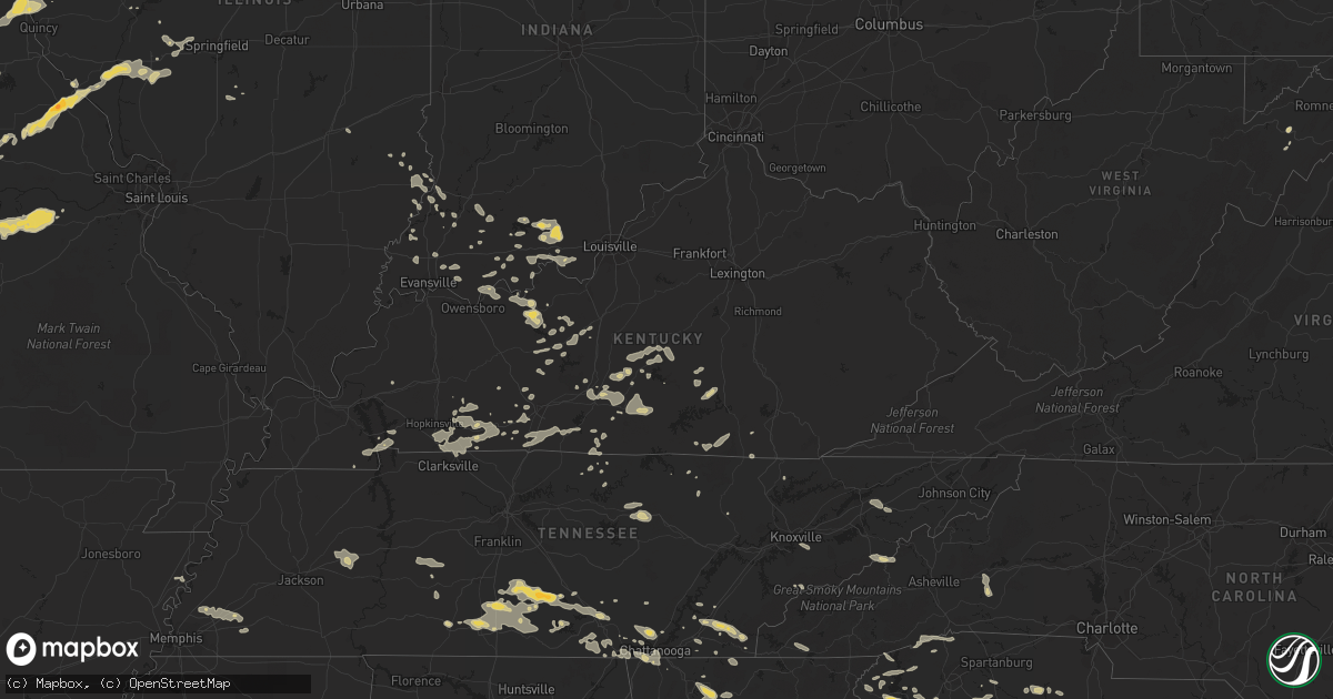
Hail Map on June 18, 2011
Get this storm
June 18 map
$229
one time, instant access
Download today. No call, no setup
Keep the $229
Bought the map and want the full workflow? Apply the entire $229 to a subscription within 7 days. None of it is wasted.
Every map, not just this one
This buys you this map. Subscription and you get every map we run, in the markets you choose from a few cities to whole states to nationwide. Plus real-time alerts the moment a storm fires.
Contact data
Name, contact info, occupancy, even credit band for addresses in the footprint. You go from where it hit to who to call.
Become the source they trust
Unlimited branding weather history reports on demand. You already have the documented answer ready for the property owner, and you are the one who showed up with it.
Property data and RoofTrace estimates
Pull up any address you have got, its value and the exact code rules for that jurisdiction, straight from One Click Code. Then RoofTrace estimates the squares, pitch, and roof value, priced the way you price.
States Impacted by Hail Map on June 18, 2011
Storm reports
Minnesota
| Date | Description |
|---|---|
| 06/18/20113:57 PM CDT | A local report indicates 1.25 inch wind near 1 SE RED WING |
Illinois
| Date | Description |
|---|---|
| 06/18/20117:38 AM CDT | Trees blown down...a few onto power lines. |
| 06/18/20117:33 AM CDT | Several trees blown down...a few onto power lines. |
| 06/18/20117:18 AM CDT | Very little bit of hail. |
| 06/18/20115:00 AM CDT | 16 inch diameter tree blown down on route 45 at route 50 intersection. |
| 06/18/20114:10 AM CDT | Power outages and disruptive phone service reported throughout the community. |
| 06/18/20114:01 AM CDT | Trees down. |
| 06/18/20114:00 AM CDT | *** 1 inj *** ...update at 430 am...camper blown over with 3 individuals trapped inside located at the du quoin state fairgrounds. Individuals had to be extracted by fi |
| 06/18/20113:45 AM CDT | Measured just west of town by trained spotter. |
| 06/18/20112:00 AM CDT | Two inch diameter tree limbs downed. Time estimated. |
Texas
| Date | Description |
|---|---|
| 06/18/20116:43 PM CDT | 11 miles northwest of gainesville |
| 06/18/20115:45 PM CDT | Ping pong hail reported near possum kingdom lake |
| 06/18/20115:30 PM CDT | Winds estimated to be around 70 mph on the east side of abilene. Large diameter trees were snapped...power poles snapped at the intersection of east highway 80 and judg |
| 06/17/201110:30 PM CDT | Numerous reports of powerlines down from river oaks to lake worth. |
| 06/17/201110:27 PM CDT | Measured at the joint reserve base...knfw. |
| 06/17/20118:26 PM CDT | Possible microburst in sadler. Unknown damage with an injury. Ems on scene. |
| 06/17/20118:23 PM CDT | *** 1 inj *** substantial damage to a home resulted in an injury. Occupant suffered a broken arm. |
| 06/17/20118:08 PM CDT | *** 1 inj *** multiple one foot diameter trees blown down. Some into houses which resulted in one injury. |
| 06/17/20117:52 PM CDT | Roof blown off the main building of the north central texas college. |
| 06/17/20117:52 PM CDT | Large trees down across roads south of gainesville. |
| 06/17/20117:45 PM CDT | Gutters and siding blown off of a home. Glass patio table thrown and shattered. Est. 80 mph |
| 06/17/20117:22 PM CDT | Lots of 6+ inch tree limps down in muester. One fell on a car. |
| 06/17/20117:13 PM CDT | Reported at a gas station in alvord. |
| 06/17/20117:11 PM CDT | A member of the rainfall network called with a report of downed tree limbs. The average diameter of the limb was approx 2 inches. The observer also reported a 62 mph wi |
| 06/17/20117:05 PM CDT | Golf ball sized hail reported by chico fd |
Wisconsin
| Date | Description |
|---|---|
| 06/17/201111:05 PM CDT | Few trees down on grand st on west side of la crosse airport. Tree down on house on island park blvd on sw side of la crosse airport. |
| 06/17/201111:00 PM CDT | A local report indicates 58 MPH wind near 4 N LA CROSSE |
| 06/17/201111:00 PM CDT | Trees down in the vicinity of quincy street. Also received dime sized hail and 3.5 inches of rain creating some street flooding. |
| 06/17/20117:55 PM CDT | Windows blown out in a business south side of eau claire |
Florida
| Date | Description |
|---|---|
| 06/18/20116:30 PM CDT | Wftv channel 9 reported large tree fell onto part of roof of house near intersection of simms ave. And merryweather dr. In orlando. |
| 06/18/20116:20 PM CDT | Quarter size hail along with estimated 60 mph wind gust and minor street flooding near intersection of hoffner ave. And goldenrod rd. In orlando. |
| 06/18/20116:11 PM CDT | Kmco orlando international airport asos measured a 61 kt/70 mph wind gust. |
| 06/18/20115:58 PM CDT | Quarter inch hail observed near intersection of alafaya trail and chapman rd. |
| 06/18/20115:53 PM CDT | Quarter size hail along with estimated 50 knot wind gusts and small tree branches in street observed near intersection of east mitchell hammock and kingsbridge drive in |
| 06/18/20114:37 PM CDT | Emergency management relayed report from dept of forestry of kmart sign damaged and parts on road at us 92 and west international speedway blvd. |
| 06/18/20114:15 PM CDT | 2 foot diameter tree toppled onto sidewalk near nova rd. And beville rd. Time estimated from radar. |
| 06/18/20114:15 PM CDT | 6 inch diameter tree limb down in yard on nova rd. Between cedar st. And south st. Time estimated from radar. |
| 06/18/20113:25 PM CDT | Trees reported down across powerlines along county road 309 near satsuma. |
| 06/18/20113:05 PM CDT | Ktix awos measured a 50 kt/58 mph wind gust. |
| 06/17/20117:50 PM CDT | Kcof patrick afb measured 50 kt/58 mph wind gust. |
| 06/17/20117:48 PM CDT | Kcof patrick afb measured 53 kt/61 mph wind gust. |
| 06/17/20117:36 PM CDT | Kcof patrick afb measured 56 kt/64 mph wind gust. |
| 06/17/20117:00 PM CDT | Ksc 54 foot tower number 2202 measured 56 kt/64 mph wind gust. |
Missouri
| Date | Description |
|---|---|
| 06/18/201111:50 AM CDT | A local report indicates 1.00 inch wind near BOWLING GREEN |
| 06/18/20117:28 AM CDT | Power lines down. |
| 06/18/20117:00 AM CDT | A local report indicates 1.00 inch wind near NEW HAMPTON |
| 06/18/20113:22 AM CDT | Power outages reported in portions of the community. |
| 06/18/20113:05 AM CDT | A few trees down on hwy 32 |
| 06/18/20113:00 AM CDT | Power lines down across the county |
| 06/18/20112:52 AM CDT | A local report indicates 60 MPH wind near FARMINGTON |
| 06/18/20112:50 AM CDT | Numerous trees uprooted or snapped...12 to 14 inches in diameter and up to 40 feet tall...on the south side of town. Time estimated. |
| 06/18/20112:35 AM CDT | Corrugated vinyl roof torn off a chicken coop. Chicken coop overturned. Several three to four inch diameter tree limbs down. |
| 06/18/20112:30 AM CDT | Tree limbs and power lines down |
| 06/18/20112:20 AM CDT | Tree limbs and powerlines down. Report relayed by fox2. Time estimated. |
| 06/18/20112:14 AM CDT | Tree limbs and power lines down near festus. Time estimated from radar. |
| 06/18/20112:05 AM CDT | Spotter reports significant damage to the upper floor of a 2 story house west of cherryville. Several other homes in the area sustained minor damage. Numerous trees and |
| 06/18/20112:05 AM CDT | Spotter reports significant damage to the upper floor of a 2 story house in cherryville. Numerous trees and power lines down. |
| 06/18/20112:05 AM CDT | Numerous 6 inch limbs broken out of trees. A couple of small trees snapped off near the ground. |
| 06/18/20112:05 AM CDT | Uprooted tree |
| 06/18/20112:00 AM CDT | Tree down across highway 19 north |
| 06/18/20112:00 AM CDT | Tree down across highway 68 just north of highway u |
| 06/18/20112:00 AM CDT | Tree down and blocking higway 19. |
| 06/18/20111:50 AM CDT | 18 to 30 inch diameter trees downed. Time estimated. |
| 06/18/20111:21 AM CDT | Tree down across highway 17. Already cleared. |
| 06/18/20111:15 AM CDT | All exposed car windshields cracked and/or broken. Numerous dings on vehicles from the hail. |
| 06/18/20111:06 AM CDT | A local report indicates 2.75 inch wind near 2 SE PLATTE CITY |
| 06/18/20111:04 AM CDT | Report via twitter |
| 06/18/20111:02 AM CDT | A local report indicates 1.75 inch wind near 2 SSE PLATTE CITY |
| 06/18/201112:55 AM CDT | A local report indicates 60 MPH wind near LEBANON |
| 06/18/201112:55 AM CDT | Hail lasted approximately 8 minutes. |
| 06/18/201112:55 AM CDT | Tree on a house in eldrige at hwy e and mohave dr. |
| 06/18/201112:45 AM CDT | Slightly larger than quarters |
| 06/18/201112:45 AM CDT | Trees and power lines down...estimated wind gust to 60 mph. |
| 06/18/201112:40 AM CDT | Power lines down across highway w between phillipsburg and lebanon |
| 06/18/201112:37 AM CDT | 63 mph gust measured at division and 65. Winds also estimated 60-65 mph at 104 mile marker on i-44. |
| 06/18/201112:35 AM CDT | Tree down and blocking grover road |
| 06/18/201112:30 AM CDT | Several limbs down. |
| 06/18/201112:15 AM CDT | Trees and powerlines down along farm road 35 |
| 06/18/201112:15 AM CDT | Damage to roof of kum and go in fair grove. |
| 06/18/201112:15 AM CDT | Passed on by greene county oem. |
| 06/18/201112:15 AM CDT | 63 mph gust measured at division and 65. Winds also estimated 60-65 mph at 104 mile marker on i-44. |
| 06/18/201112:12 AM CDT | A local report indicates 70 MPH wind near 2 SW BOLIVAR |
| 06/18/201112:12 AM CDT | A local report indicates 70 MPH wind near MORRISVILLE |
| 06/18/201112:07 AM CDT | A local report indicates 60 MPH wind near WALNUT GROVE |
| 06/18/201112:03 AM CDT | Ground survey confirmed an ef-0 tornado produced 70 to 80 mph winds along an east southeast path between three miles southeast of brighton...just north of the greene co |
| 06/18/201112:03 AM CDT | 60 to 70 mph wind gust estimated |
| 06/18/201112:00 AM CDT | Barn destroyed...shingles off of a roof...and 6-8 inch tree limbs reported down along greene county farm roads 2 and 6. Reported by polk county ema. |
| 06/17/201111:52 PM CDT | A local report indicates 1.75 inch wind near HENRIETTA |
| 06/17/201111:47 PM CDT | Deputies reported golf ball size hail in bowling green |
| 06/17/201111:45 PM CDT | A local report indicates 1.50 inch wind near BOWLING GREEN |
| 06/17/201111:41 PM CDT | Numerous trees down across central and eastern portions of dade county. |
| 06/17/201111:40 PM CDT | A nws survey team determined that an ef-1 tornado with estimated winds of 80-90 mph occurred on june 18th. The storm touched down around 1140 pm about 2 miles southeast |
| 06/17/201111:35 PM CDT | A nws survey team determined that an ef-1 tornado with winds of 80-90 mph occurred on june 18th. The tornado touched down around 1135 pm about 4 miles northeast of ever |
| 06/17/201111:35 PM CDT | Power lines down |
| 06/17/201111:34 PM CDT | Pea to quarter sized hail reported |
| 06/17/201111:30 PM CDT | A local report indicates 60 MPH wind near GREENFIELD |
| 06/17/201111:24 PM CDT | Home weather station measured wind gust of 83 mph |
| 06/17/201111:24 PM CDT | Tin roof off of a business |
| 06/17/201111:20 PM CDT | Along with pea sized hail |
| 06/17/201111:11 PM CDT | Trees down in purcell |
| 06/17/201111:01 PM CDT | A local report indicates 1.75 inch wind near 1 WNW BLUE SPRINGS |
| 06/17/201110:50 PM CDT | Grain bin destroyed...wind gust estimated at 80 mph. |
| 06/17/201110:40 PM CDT | A local report indicates 1.00 inch wind near 1 E LONE JACK |
| 06/17/201110:31 PM CDT | A local report indicates 1.00 inch wind near 1 E LONE JACK |
| 06/17/201110:30 PM CDT | 5 inch tree branches down |
| 06/17/201110:16 PM CDT | A local report indicates 1.50 inch wind near 3 SE GARDEN CITY |
| 06/17/201110:00 PM CDT | A local report indicates 1.75 inch wind near 5 S PLEASANT HILL |
| 06/17/20119:55 PM CDT | A local report indicates 1.00 inch wind near NW HARRISONVILLE |
| 06/17/20119:45 PM CDT | Photos sent into nws via local media |
| 06/17/20119:42 PM CDT | A local report indicates 1.50 inch wind near HARRISONVILLE |
| 06/17/20119:42 PM CDT | A local report indicates 1.00 inch wind near PECULIAR |
| 06/17/20119:40 PM CDT | A local report indicates 1.00 inch wind near 1 W CREIGHTON |
| 06/17/20119:35 PM CDT | A local report indicates 1.00 inch wind near 3 SE GARDEN CITY |
| 06/17/20119:33 PM CDT | Nickle to one half dollar size hail along western city limits of jefferson city |
| 06/17/20119:30 PM CDT | Quarter size hail on west side of jefferson city. |
| 06/17/20119:25 PM CDT | Northwest side of jefferson city. |
| 06/17/20119:22 PM CDT | Quarter to golfball size hail beginning to cover the ground in westview heights area. |
| 06/17/20119:21 PM CDT | A local report indicates 1.00 inch wind near ST. MARTINS |
| 06/17/20119:20 PM CDT | One half dollar size hail 2.5 miles west of jefferson city |
| 06/17/20119:07 PM CDT | Deputy sheriff 2 miles south of jefferson city reported golfball size hail |
| 06/17/20119:03 PM CDT | A local report indicates 1.75 inch wind near WINDSOR |
| 06/17/20119:00 PM CDT | A local report indicates 1.75 inch wind near WINDSOR |
| 06/17/20118:53 PM CDT | A local report indicates 1.75 inch wind near 2 ENE ARCHIE |
| 06/17/20118:35 PM CDT | A local report indicates 1.75 inch wind near LAKELAND |
| 06/17/20118:35 PM CDT | Relayed by krcg tv |
| 06/17/20118:35 PM CDT | A local report indicates 1.25 inch wind near CALHOUN |
Indiana
| Date | Description |
|---|---|
| 06/18/20116:58 AM CDT | A local report indicates 60 MPH wind near CORYDON |
| 06/18/20116:53 AM CDT | Numerous trees down...power lines down |
| 06/18/20116:47 AM CDT | The roof was blown off the posey township fire house. Some bleachers and an announcers booth were blown about 50 yards. |
| 06/18/20116:35 AM CDT | Several trees downed around valeene. |
| 06/18/20116:33 AM CDT | Numerous trees down around the county. |
| 06/18/20116:13 AM CDT | Power line down at 2nd st. And shipping st. In edwardsport. |
| 06/18/20116:09 AM CDT | Large tree down. |
| 06/18/20116:05 AM CDT | Several small trees down. |
| 06/18/20115:59 AM CDT | A local report indicates 66 MPH wind near ROCKPORT |
| 06/18/20115:30 AM CDT | Event occurred on the east side of town. |
| 06/18/20115:27 AM CDT | Power lines down. Reported near the community of angel mounds. |
| 06/18/20115:17 AM CDT | A local report indicates 61 MPH wind near 2 E MOUNT VERNON |
| 06/18/20115:13 AM CDT | Reported by spotter and relayed through media. |
North Carolina
| Date | Description |
|---|---|
| 06/18/20116:54 PM CDT | Several large trees blown down on mote road near white lake. Report relayed through local tv meteorologist. |
| 06/18/20116:30 PM CDT | 10 to 15 trees down between clinton and garland |
| 06/18/20116:20 PM CDT | Tree down across john mitchel road at 720 pm and a few other tress down nearby on nc 96 |
| 06/18/20116:15 PM CDT | Roof blown off mobile home on singletary church rd. Time of event estimated by radar. |
| 06/18/20115:50 PM CDT | Powerlines down across roadway on dobbs drive. Time of event estimated by radar. |
| 06/18/20115:48 PM CDT | Tree down |
| 06/18/20115:45 PM CDT | Three trees down across bridgers rd near purvis rd. Time of event estimated by radar. |
| 06/18/20115:45 PM CDT | Tree down at 645 pm |
| 06/18/20115:45 PM CDT | Reported tree down on north chicken rd near hwy 211 west. Time of event estimated by radar. |
| 06/18/20115:43 PM CDT | Tree down near fayetteville |
| 06/18/20115:40 PM CDT | Reported trees down near intersection of union chapel rd and barber shop rd. Time of event estimated by radar. |
| 06/18/20115:38 PM CDT | Tree down on house |
| 06/18/20115:33 PM CDT | A local report indicates 58 MPH wind near FT BRAGG SIMMONS AAF |
| 06/18/20115:32 PM CDT | 8 inch diameter tree down |
| 06/18/20115:25 PM CDT | Tree down on fulford mcmillan road |
| 06/18/20115:21 PM CDT | Trees down |
| 06/18/20115:20 PM CDT | Approximately 6 trees down in lee county |
| 06/18/20115:20 PM CDT | Trees down across county |
| 06/18/20115:15 PM CDT | Tree down on shed |
| 06/18/20115:13 PM CDT | Tree down |
| 06/18/20115:13 PM CDT | 4 inch diameter tree down... 3 inch diamter limb down |
| 06/18/20115:10 PM CDT | 10 large trees down along furr road... 1 tree measured at 1 foot in diameter |
| 06/18/20115:05 PM CDT | Tree down on white cross road |
| 06/18/20115:04 PM CDT | Trees down near west end |
| 06/18/20114:58 PM CDT | Tree down near hamlet |
| 06/18/20114:53 PM CDT | Tree down on pirate lane |
| 06/18/20114:50 PM CDT | Tree down on spanish oak road |
| 06/18/20114:50 PM CDT | Tree down on durham st extension |
| 06/18/20114:45 PM CDT | Power lines blown down |
| 06/18/20114:35 PM CDT | *** 1 fatal *** tree limb snapped and killed a 39 year old woman on blewett falls road in lilesville. The strong winds associated with the storm were out in advance of |
| 06/18/20114:35 PM CDT | Six inch diameter tree down |
| 06/18/20114:30 PM CDT | Several trees down. |
| 06/18/20114:30 PM CDT | 1 foot diameter tree blown over... 52 mph wind measured by anemometer |
| 06/18/20114:25 PM CDT | Tree down |
| 06/18/20114:25 PM CDT | Tree down |
| 06/18/20114:25 PM CDT | Tree down |
| 06/18/20114:25 PM CDT | Tree down on mt vernon road |
| 06/18/20114:25 PM CDT | Numerous trees down in randolph county |
| 06/18/20114:20 PM CDT | Widespread tree and power line damage across the county. |
| 06/18/20114:15 PM CDT | Large branches broken |
| 06/18/20114:10 PM CDT | Several trees down in the ranger area. |
| 06/18/20114:08 PM CDT | 12 inch diameter tree snapped in half |
| 06/18/20114:05 PM CDT | Several trees down. |
| 06/18/20114:00 PM CDT | 18 inch diameter limb down |
| 06/18/20113:56 PM CDT | Large branches broken |
| 06/18/20113:56 PM CDT | Public reported large tree limbs blown down in the mineral springs area. |
| 06/18/20113:55 PM CDT | Large branches broken |
| 06/18/20113:50 PM CDT | Tree down on kennedy road at 450 pm |
| 06/18/20113:50 PM CDT | Power line damaged by falling limb |
| 06/18/20113:49 PM CDT | Several trees down |
| 06/18/20113:47 PM CDT | Numeous tress down |
| 06/18/20113:45 PM CDT | Approximately 6-12 trees down across davidson county. |
| 06/18/20113:44 PM CDT | Power lines down along magnolia ave |
| 06/18/20113:41 PM CDT | Trees down near rocky river and hood roads |
| 06/18/20113:40 PM CDT | Large branches broken |
| 06/18/20113:39 PM CDT | Trees down along barrington dr |
| 06/18/20113:38 PM CDT | Ham radio operator reported a tree down through a house on 7th street...with power lines also down in the area. |
| 06/18/20113:38 PM CDT | Powerlines down along farmbrook dr |
| 06/18/20113:34 PM CDT | Ham radio operator reported power lines down on highway 29. |
| 06/18/20113:33 PM CDT | Powerlines down near central ave and st. Julien st |
| 06/18/20113:31 PM CDT | Public reports a large tree down blocking wilann dr. |
| 06/18/20113:30 PM CDT | Tree down on hendrick mill road at 430 pm |
| 06/18/20113:30 PM CDT | Tree fell on a house and through the roof at 4000 country club road in western winston-salem |
| 06/18/20113:28 PM CDT | Trees down near tyvola rd and old statesville rd |
| 06/18/20113:25 PM CDT | Tree down on swicegood road |
| 06/18/20113:24 PM CDT | Trees down on east cook st |
| 06/18/20113:24 PM CDT | Trees down on woodstone dr |
| 06/18/20113:23 PM CDT | Powerlines down oak drive |
| 06/18/20113:23 PM CDT | Ham radio operator reports power lines down on woodleaf rd. |
| 06/18/20113:14 PM CDT | Em reports trees and power lines down at mount ulla hwy and triplett rd. |
| 06/18/20113:12 PM CDT | Trees down near crowders creek rd and wild wing dr |
| 06/18/20113:07 PM CDT | Em reports trees and power lines down on stonemaker rd. |
| 06/18/20113:07 PM CDT | Em reports trees and power lines down on stonemaker rd. |
| 06/18/20113:06 PM CDT | Trees down |
| 06/18/20113:05 PM CDT | Large tree limbs down on crowders creek rd near whitworth rd. |
| 06/18/20113:04 PM CDT | Trees down on east pine street in flat rock area. |
| 06/18/20113:00 PM CDT | A tree fell down on westlake drive. |
| 06/18/20113:00 PM CDT | Em reports power lines down on highway 901. |
| 06/18/20112:57 PM CDT | Numerous trees down in and around the city on country club road...fancy gap road...springs road...and on highway 52 just west of town. Tree down on house on springs roa |
| 06/18/20112:51 PM CDT | Trees down |
| 06/18/20112:47 PM CDT | A tree fell across dobbins mill road. |
| 06/18/20112:47 PM CDT | A large limb fell across west atkins street near the elementary school. |
| 06/18/20112:45 PM CDT | Ham radio operator reports trees and power lines blown down at long branch rd and east dixon rd. One tree is on a house on long branch rd. |
| 06/18/20112:39 PM CDT | Spotter reported a tree down on power lines and large limbs down near south post rd and highway 18. |
| 06/18/20112:37 PM CDT | Trees and powerlines down across parts of the city |
| 06/18/20112:37 PM CDT | Ham radio operator reported numerous trees blown down on patterson rd. |
| 06/18/20112:34 PM CDT | Spotter reports numerous trees blown down in the lattimore area |
| 06/18/20112:34 PM CDT | Tree and powerlines down mooresboro and devon rds |
| 06/18/20112:25 PM CDT | Spotter reported multiple trees blown down. |
| 06/18/20112:22 PM CDT | Public reported trees blown down |
| 06/18/20112:15 PM CDT | Damage to a tin barn. |
| 06/18/20112:15 PM CDT | A tree was blown down on route 21. |
| 06/18/20112:15 PM CDT | Tree down on powerlines on north lake summit road. 911 center reported trees down all areas of county. |
| 06/18/20112:10 PM CDT | A local report indicates 64 MPH wind near 4 SE MORGANTON |
| 06/18/20112:10 PM CDT | Powerlines down on connelly springs rd...caught tree on fire. |
| 06/18/20112:09 PM CDT | A tree was blown down on us route 221. |
| 06/18/20112:07 PM CDT | Tree on a house on hemlock dr ne |
| 06/18/20112:05 PM CDT | Trees down on powerlines. |
| 06/18/20112:00 PM CDT | A tree was blown down at the intersection of route 113 and route 221. |
| 06/18/20111:58 PM CDT | A tree was blown down on route 113. |
| 06/18/20111:58 PM CDT | A tree was blown down at the 4800 block of route 113. |
| 06/18/20111:58 PM CDT | A tree was blown down at 1700 allen road. |
| 06/18/20111:57 PM CDT | Tree down along highway 74 |
| 06/18/20111:56 PM CDT | Three trees were blown down on weaver road. |
| 06/18/20111:55 PM CDT | A tree fell on chestnut hill road. |
| 06/18/20111:55 PM CDT | Trees and powerlines down on brown mtn beach rd |
| 06/18/20111:54 PM CDT | Powerlines down on pace rd |
| 06/18/20111:50 PM CDT | Public reported trees blown down in the marion area. |
| 06/18/20111:50 PM CDT | Tree down on naples rd |
| 06/18/20111:47 PM CDT | One tree down on nc highway 88 and another fell on a power line on east main street. |
| 06/18/20111:43 PM CDT | Tree down on west deep ford. |
| 06/18/20111:42 PM CDT | One foot thick tree across cimarron rd |
| 06/18/20111:42 PM CDT | Tree on powerline on greenwood acres drive |
| 06/18/20111:40 PM CDT | Tree on vehicle and blocking shady bottom rd |
| 06/18/20111:35 PM CDT | A tree fell on a power line on hickory heights drive. |
| 06/18/20111:35 PM CDT | Trees down all over the county. |
| 06/18/20111:27 PM CDT | Tree down on bee tree rd |
| 06/18/20111:27 PM CDT | Tree on vehicle and blocking shady bottom rd |
| 06/18/20111:25 PM CDT | Trees down and roof off house on shope creek road in the riceville area. |
| 06/18/20111:20 PM CDT | Trees down on beech mtn parkway and on wedling weg rd in beech mtn. |
| 06/18/20111:15 PM CDT | Roof off a structure on majestic mountain dr |
| 06/18/20111:15 PM CDT | Tree down piney knob rd and horseback lane |
| 06/18/20111:13 PM CDT | Powerlines down and started a fire |
| 06/18/20111:12 PM CDT | Tree down near flint hill rd and panther branch rd |
| 06/18/201112:59 PM CDT | Tree across crawford rd |
| 06/18/201112:59 PM CDT | Tree across crawford rd near iron duff rd |
| 06/18/20116:55 AM CDT | Power lines down along oneil circle. |
| 06/18/20116:20 AM CDT | Trees down along hwy 25/70 north of marshall. |
| 06/18/20114:25 AM CDT | Tree down on garage in walnut community. |
| 06/17/20117:51 PM CDT | Trees down along with powerlines and transformer on e. Southerland st |
| 06/17/20117:31 PM CDT | Trees down on frank cottle rd |
| 06/17/20117:12 PM CDT | Trees down along with power lines and transformer on nash johnson pond rd. |
Kentucky
| Date | Description |
|---|---|
| 06/18/20116:43 AM CDT | Ef-0 tornado damaged the roof of a well constructed barn. |
| 06/18/20116:42 AM CDT | Part of gymnasium roof blown off near hwy 1401 and richard moore road... Barns... Shed... And carports damaged near harned... Locust hill... And westview |
| 06/18/20116:40 AM CDT | Trees down on big bend road. |
| 06/18/20116:40 AM CDT | Roof blown off house |
| 06/18/20116:39 AM CDT | Ef-2 tornado removed roof from home...destroyed barns...and snapped and uprooted trees. |
| 06/18/20116:38 AM CDT | Tree limbs down as well as a few trees. |
| 06/18/20116:20 AM CDT | A tree was reported down on highway 144 e in patesville. Also...another tree was reported down along state road 2181 between pelleville and hawesville. |
| 06/18/20116:00 AM CDT | Tree across hwy 200 in the number one community. |
| 06/18/20116:00 AM CDT | Late report. |
| 06/18/20115:55 AM CDT | Event occurred on west side of town. |
| 06/18/20115:50 AM CDT | Widespread power outages. |
Virginia
| Date | Description |
|---|---|
| 06/18/20115:40 PM CDT | 6 inch diameter tree limb down on power lines on 3200 block of forest brook rd |
| 06/18/20115:33 PM CDT | Tree down at 382 homewood drive |
| 06/18/20114:17 PM CDT | Tree down about a half mile north of the intersection of route 40 and 122. |
| 06/18/20114:15 PM CDT | A tree fell bringing doen a power pole and power lines at 700 orange ave ne. |
| 06/18/20114:12 PM CDT | A few small trees down near highlane ave se. |
| 06/18/20114:00 PM CDT | Tree down on philpott drive |
New Hampshire
| Date | Description |
|---|---|
| 06/18/20115:24 PM CDT | A local report indicates 1.00 inch wind near ROCHESTER |
| 06/18/20115:20 PM CDT | Large branches down |
| 06/18/20114:50 PM CDT | A local report indicates 1.00 inch wind near CORNISH |
| 06/18/20114:14 PM CDT | Sailboat capsized near black cat island |
Tennessee
| Date | Description |
|---|---|
| 06/18/20113:25 PM CDT | Numerous trees and power lines down. |
| 06/18/20113:20 PM CDT | 4 trees down. |
| 06/18/20113:15 PM CDT | A local report indicates 1.00 inch wind near CALHOUN |
| 06/18/20113:00 PM CDT | Numerous trees and power lines down. |
| 06/18/20112:37 PM CDT | Numerous trees down in dunlap. Reported by dispatch. |
| 06/18/20112:36 PM CDT | Tree reported down on house along with a tin structure badly damaged. |
| 06/18/20112:20 PM CDT | Trees and powerlines were knocked down in huntland. |
| 06/18/20112:13 PM CDT | Large trees were knocked down on jump off road and on highway 41 in st. Andrews. Time estimated by radar. |
| 06/18/20112:12 PM CDT | A tree was knocked down onto a home in the flintville area on quarters crossroads road. Time and location estimated. |
| 06/18/20112:12 PM CDT | Large trees and branches were knocked down on the campus of the university of the south. Time estimated by radar. |
| 06/18/20112:06 PM CDT | A tree was knocked down on a home in the 400 block of bennett street. Time estimated by radar. |
| 06/18/20112:06 PM CDT | Along prospect road. Fences and trailers were damaged. A 3 foot diameter oak tree was knocked down. Time estimated by radar. |
| 06/18/20112:06 PM CDT | Several trees were knocked on highway 231. Time estimated by radar. |
| 06/18/20112:06 PM CDT | Trees and power lines were knocked down in alto. Time estimated by radar. |
| 06/18/20112:05 PM CDT | A 5 to 6 foot diameter tree was knocked down on monks road. Time estimated by radar. |
| 06/18/20112:03 PM CDT | A 5 foot diameter tree was knocked down on simmons road. Time estimated by radar. |
| 06/18/20112:00 PM CDT | A roof was blown off of a barn in the taft area on highway 110/ardmore highway. Time and location estimated. |
| 06/18/20111:58 PM CDT | Several tree down near chapel hill |
| 06/18/20111:55 PM CDT | Trees were knocked down onto a home in the capital hill community. Time estimated by radar. |
| 06/18/20111:55 PM CDT | Minor roof damage. |
| 06/18/20111:55 PM CDT | A tree was knocked down on a home in the 4900 block of aedc road. Time estimated by radar. |
| 06/18/20111:50 PM CDT | Minor roof damage. |
| 06/18/20111:45 PM CDT | Several trees down near cornersville |
| 06/18/20111:45 PM CDT | Large branches in roads |
| 06/18/20111:35 PM CDT | Several trees down south of pulaski and large oak trees stripped. |
| 06/18/20111:35 PM CDT | A local report indicates 80 MPH wind near 1 S PULASKI |
| 06/18/20111:23 PM CDT | Power lines down on west 17th street at woodland park |
| 06/18/20111:18 PM CDT | A local report indicates 1.50 inch wind near SHELBYVILLE |
| 06/18/201112:40 PM CDT | One house destroyed and another with structural damage in southern perry county |
| 06/18/201112:27 PM CDT | Power lines and trees down along and near highway 100. |
| 06/18/201112:05 PM CDT | A couple of trees reported down southwest of camden |
| 06/18/201112:00 PM CDT | Roofing damaged on home along independence loop. |
| 06/18/201112:00 PM CDT | *** 1 inj *** tree fell on home. 1 injury reported at this time. |
| 06/18/201112:00 PM CDT | A local report indicates 70 MPH wind near LEXINGTON |
| 06/18/201111:48 AM CDT | Couple large trees down near hoan creek between yuma and clarksburg. |
| 06/18/201110:50 AM CDT | Four large trees knocked down across the county |
| 06/18/201110:40 AM CDT | A local report indicates 60 MPH wind near MARTIN |
Iowa
| Date | Description |
|---|---|
| 06/18/20117:32 AM CDT | Two large branches down in the north side of town...one crossing the road...time estimated from radar |
Vermont
| Date | Description |
|---|---|
| 06/18/20111:45 PM CDT | Pittsford country club |
| 06/18/20111:00 PM CDT | Stowe mountain road |
| 06/18/201112:55 PM CDT | Traveling on upper pleasant valley road near underhill state park |
| 06/18/201112:52 PM CDT | A local report indicates 1.00 inch wind near MONTGOMERY |
| 06/18/201112:50 PM CDT | A local report indicates 1.75 inch wind near 2 E ENOSBURG CENTER |
| 06/18/201112:50 PM CDT | Driving on route 118 between enosburg falls and montogery center |
| 06/18/201112:45 PM CDT | Located on dean and corbertt roads in underhill |
| 06/18/201112:45 PM CDT | Pittsford country club |
North Dakota
| Date | Description |
|---|---|
| 06/17/20117:59 PM CDT | Relay by state radio |
Oklahoma
| Date | Description |
|---|---|
| 06/18/20116:49 PM CDT | Win star golf course |
| 06/18/20116:49 PM CDT | Winstar golf course |
| 06/18/20115:15 PM CDT | A local report indicates 1.75 inch wind near SPRINGER |
| 06/18/20114:25 PM CDT | A local report indicates 1.00 inch wind near 3 E HEALDTON |
| 06/17/201110:01 PM CDT | A local report indicates 1.00 inch wind near SOUTH COFFEYVILLE |
| 06/17/20119:10 PM CDT | Spotter reported golf ball hail in the copan lake area. |
| 06/17/20118:25 PM CDT | Several storms chasers...storm spotters and at least one off duty nws meteorologist witnessed this tornado. It lasted 10 to 15 minutes and produced no known damage. |
| 06/17/20118:09 PM CDT | Live video of brief tornado was broadcasted by kjrh |
Georgia
| Date | Description |
|---|---|
| 06/18/20116:20 PM CDT | Camper at elijah clarke state park reports quarter sized hail. |
| 06/18/20116:10 PM CDT | Trees down county wide. |
| 06/18/20116:05 PM CDT | A total of 8 trees down in lexington and crawford areas. |
| 06/18/20115:50 PM CDT | 4 trees and numerous power lines down in athens. The city of athens is without power. |
| 06/18/20115:46 PM CDT | *** 1 fatal *** 1 tree fell on a car and killed 1 person on powers ferry rd |
| 06/18/20115:45 PM CDT | At least 6 trees down from watkinsville to east of bishop. |
| 06/18/20115:30 PM CDT | Numerous trees down in all areas of franklin co. |
| 06/18/20115:29 PM CDT | A local report indicates 1.00 inch wind near SMYRNA |
| 06/18/20115:25 PM CDT | At least 11 trees down in county line area. |
| 06/18/20115:23 PM CDT | A local report indicates 1.00 inch wind near 3 ESE MONROE |
| 06/18/20115:15 PM CDT | 2 trees down on 2 cars in marietta. Numerous other trees down across the county. |
| 06/18/20115:15 PM CDT | A local report indicates 1.00 inch wind near 5 SSE MARIETTA |
| 06/18/20115:15 PM CDT | A local report indicates 1.00 inch wind near 1 W MONROE |
| 06/18/20115:15 PM CDT | 4 trees down west of monroe. Also quarter sized hail. |
| 06/18/20115:13 PM CDT | Spotter reports trees and power lines down in the highway 17 area. |
| 06/18/20115:00 PM CDT | Trees down on houses. |
| 06/18/20115:00 PM CDT | Gwinnett county 911 call center relayed a report of powerlines down in the buford area. |
| 06/18/20115:00 PM CDT | Trees down on houses. |
| 06/18/20115:00 PM CDT | Damage to billboard and traffic light. |
| 06/18/20114:58 PM CDT | Trees and lines down across the county. |
| 06/18/20114:40 PM CDT | Numerous trees down across the county with several reported in the dallas area. |
| 06/18/20114:40 PM CDT | Cherokee county ema relayed a report of widespread tree damage throughout the county. |
| 06/18/20114:31 PM CDT | Dawson county 911 relayed a report of at least 30-50 trees down across the county. |
| 06/18/20114:21 PM CDT | Pickens county ema relayed a report of widespread tree damage county wide. Ema also reports trees down on structures and across some roads. |
| 06/18/20114:20 PM CDT | A local report indicates 1.75 inch wind near HERNDONVILLE |
| 06/18/20114:15 PM CDT | Numerous trees down across the county to include in the downtown ellijay area. |
| 06/18/20114:10 PM CDT | At least 6 trees down with multiple power lines down in epworth area. |
| 06/18/20113:40 PM CDT | 3 trees down in the town. |
| 06/18/20113:40 PM CDT | 2 trees down on houses in rocky face. |
| 06/18/20113:40 PM CDT | 4 trees down on 4 different houses within the city. |
| 06/18/20113:30 PM CDT | 3 trees down in town. |
| 06/18/20113:20 PM CDT | The public reports multiple trees down at this location. Other reports from chickamauga are three trees down in the city with one down on a car and dime size hail. |
| 06/18/20113:20 PM CDT | Six trees down just north of chickamauga. |
| 06/18/20113:05 PM CDT | At least six trees down across the county...1 tree down across i-59 about 3 miles north of trenton... And numerous trees down across parts of look out moutain east and |
| 06/18/201110:44 AM CDT | Broadcast meteorologist reported numerous trees down on bradley point road and johnny mercer blvd. |
| 06/18/201110:43 AM CDT | Numerous trees down along jonny mercer blvd and hwy 80... Near the wilmington island bridge. |
| 06/17/201111:03 PM CDT | Public official reported trees down on 54th and waters ave. Time estimated by radar. |
| 06/17/201111:03 PM CDT | Public official reported a tree down over power lines on 37th street. Time estimated by radar. |
| 06/17/201110:44 PM CDT | Broadcast meteorologist reported numerous trees down on bradley point road and johnny mercer blvd. |
| 06/17/201110:43 PM CDT | Media relayed viewer report of a plum tree and pine tree uprooted in yard. Small storage shed destroyed by fallen trees. |
| 06/17/201110:43 PM CDT | 1 large pine tree down. Numerous large branches and power lines down. |
| 06/17/201110:43 PM CDT | Numerous trees down along jonny mercer blvd and hwy 80... Near the wilmington island bridge. |
| 06/17/201110:34 PM CDT | Spotter reported large tree on road near intersection of chatham parkway and highway 17. |
| 06/17/201110:34 PM CDT | Spotter reported trees down near gould elementary. |
| 06/17/201110:15 PM CDT | Public report of power lines down. |
| 06/17/20119:59 PM CDT | Dispatch center reported trees down along ray rd at stable rd and mary todd rd. |
| 06/17/20119:55 PM CDT | Public reported large tree branch broken over power lines. |
| 06/17/20119:54 PM CDT | 911 center reported tree down on palmer road. |
| 06/17/20119:50 PM CDT | 911 center reported a power line down on rye patch road. |
| 06/17/20119:32 PM CDT | Reports of numerous trees down near glennville. Time estimated by radar. |
| 06/17/20119:14 PM CDT | 911 center reported tree down on oc banks road. |
| 06/17/20119:10 PM CDT | Dispatch center reported tree down on ga hwy 17n near harry lindsay rd. |
| 06/17/20118:52 PM CDT | 911 center reported tree down near intersection of sunbury rd and red mill rd. |
| 06/17/20118:34 PM CDT | Multiple reports of numerous trees down along effingham hwy and capitola road. Time estimated by radar. |
| 06/17/20118:00 PM CDT | Report from sherriffs office of a few trees down across county roadways |
West Virginia
| Date | Description |
|---|---|
| 06/18/20115:05 PM CDT | Limbs and branches down from thunderstorm wind and blocking a few roadways south of williamsport rd in western hardy county. |
South Carolina
| Date | Description |
|---|---|
| 06/18/20116:20 PM CDT | Report of tree down on lanneiu snipes rd near sc 41. Time of event estimated by radar. |
| 06/18/20116:15 PM CDT | Tree in roadway near us 76 and brick mill rd |
| 06/18/20115:53 PM CDT | Tree in roadway...near i-85 mm 11 |
| 06/18/20115:45 PM CDT | Powerlines in road...hw-187 and fisher jenkins rd. |
| 06/18/20115:30 PM CDT | Couple trees down along hwy 67 near callison. |
| 06/18/20115:26 PM CDT | Trees down near us highway 76 and hiller rd. |
| 06/18/20115:25 PM CDT | Em reported trees down in cheraw on laney and old cash roads. |
| 06/18/20115:24 PM CDT | Trees down near morningside drive and beatty rd in west columbia. |
| 06/18/20115:20 PM CDT | Sc hwy patrol reports tree in road near intersection of seagull lane and osprey point at lake murray |
| 06/18/20115:20 PM CDT | Several trees down along hwy 702 east of ninety six. |
| 06/18/20115:19 PM CDT | Kbbp asos reported gust of 58 mph. |
| 06/18/20115:18 PM CDT | Report of tree down on sc 9. Time of event estimated by radar. |
| 06/18/20115:17 PM CDT | Tree down on east old camden rd near sister sister. |
| 06/18/20115:17 PM CDT | Reported tree down on new hopewell rd. Time of event estimated by radar. |
| 06/18/20115:16 PM CDT | Tree down on east old camden rd near sister sister. Event time estimated by radar. |
| 06/18/20115:16 PM CDT | Tree down near intersection of s fifth street and patrick hwy. Time of event estimated by radar. |
| 06/18/20115:16 PM CDT | Reported tree down on bethlehem rd between us hwy 15 and byrdtown rd. Time of event estimated by radar. |
| 06/18/20114:58 PM CDT | Sherriff office reports trees down on brocks mill road. Time estimated by radar. |
| 06/18/20114:30 PM CDT | Tree in roadway along us 25 |
| 06/18/20114:21 PM CDT | Sc hwy patrol reports tree in roadway near sc hwy 56 and brehmer road. |
| 06/18/20114:18 PM CDT | Tree in roadway along sam hodges and morgan rds |
| 06/18/20114:15 PM CDT | Sherriffs dispatch reports numerous trees down countywide including the city of newberry. |
| 06/18/20113:55 PM CDT | Awos at lancaster county mcwhirter field airport observed a wind gust of 50 knots..or 58 mph. |
| 06/18/20113:53 PM CDT | Tree in roadway near young rd and us 76. |
| 06/18/20113:50 PM CDT | Media reported several trees and large limbs down on york st. |
| 06/18/20113:45 PM CDT | County sherriff reports numerous trees and powerlines down between hwy 5 south to the city of lancaster |
| 06/18/20113:44 PM CDT | Tree in road...simpson rd and harmony church rd. |
| 06/18/20113:38 PM CDT | Highway patrol reports a tree down on highway 308 just north of the city...with another tree on young rd 3 se of town. |
| 06/18/20113:38 PM CDT | Tree in roadway along hw-308 |
| 06/18/20113:30 PM CDT | Ham radio operator reported power lines down on dawson dr. Other power lines are down in the western part of the county. |
| 06/18/20113:21 PM CDT | Tree in roadway near ora rd and us 221 |
| 06/18/20113:15 PM CDT | Ice cube size hail on coneross creek rd- between quarter and golf ball size. |
| 06/18/20113:02 PM CDT | Spotter reports large limbs down on phone lines on forest st. |
| 06/18/20112:47 PM CDT | Ham radio operator reported trees down at highway 29 and highway 105. |
| 06/18/20112:45 PM CDT | Tree in roadway near east cherokee st |
| 06/18/20112:45 PM CDT | Tree down near i-85 mm104 |
| 06/18/20112:45 PM CDT | Ham radio operator reports trees down on north st and duncan st. |
| 06/18/20112:45 PM CDT | 8-10 inch diameter tree snapped off lindsey ridge rd |
| 06/18/20112:44 PM CDT | Ham radio operator reports a tree down on a house on fulton ave...with fire dept dispatched to extract occupants |
| 06/18/20112:35 PM CDT | Tree in roadway highway 9 and business 85 |
| 06/18/20112:22 PM CDT | Ham radio operator reported power lines down at cannon ford rd and country estates rd. Also highway patrol reports a tree down on coley spring rd- 3 ne |
| 06/18/20112:20 PM CDT | Tree in roadway cooley springs rd and mcswain rd |
| 06/18/20112:17 PM CDT | Powerlines down on red hill lane |
| 06/18/20112:13 PM CDT | Tree in roadway near us 178 and rocky bottom rd |
| 06/18/20111:30 PM CDT | Trees down on powerlines on dr. Johns rd. |
| 06/17/201110:00 PM CDT | Large oak tree down near the intersection of main road and river road. |
| 06/17/20119:59 PM CDT | Nws employee reported large tree down along bees ferry rd. |
| 06/17/20119:41 PM CDT | Dispatch center reported trees down on colony gardens rd. |
| 06/17/20119:14 PM CDT | Dispatch center reported trees down near jenkins and green circle. |
| 06/17/20119:10 PM CDT | Dispatch center reported trees down on bailey rd. |
| 06/17/20119:09 PM CDT | Dispatch center reported trees down near big estate rd and river rd. |
| 06/17/20119:07 PM CDT | County officials relayed numerous reports of trees and power lines down. Time estimated by radar. |
| 06/17/20119:01 PM CDT | Dispatch center reported trees down near old sheldon church and castle hall rd. |
| 06/17/20119:01 PM CDT | Dispatch center reported trees down at la creuset rd and river rd. |
| 06/17/20119:00 PM CDT | County officials relayed numerous reports of trees down across the northern portion of the county. Time estimated by radar. |
| 06/17/20119:00 PM CDT | County officials relayed numerous reports of trees down. Time estimated by radar. |
| 06/17/20118:42 PM CDT | Numerous reports of trees down along yemassee hwy and walterboro hwy. Time estimated by radar. |
| 06/17/20118:23 PM CDT | Trees down on low country highway...reported by schp. |
| 06/17/20118:21 PM CDT | Trees and powerlines down in various locations in allendale county. |
| 06/17/20118:08 PM CDT | Numerous reports of trees down along yemassee hwy and walterboro hwy. Time estimated by radar. |
| 06/17/20117:40 PM CDT | Trees down at the intersection of powderhouse rd and vanderbilt dr southeast of aiken. |
| 06/17/20117:15 PM CDT | Sc hwy patrol reports trees down on interstate 20 between mile markers 2 and 5. |
Kansas
| Date | Description |
|---|---|
| 06/18/20116:42 PM CDT | A local report indicates 2.50 inch wind near 2 ENE MAPLE CITY |
| 06/18/20116:40 PM CDT | Reports of power outagages in arkansas city. |
| 06/18/20116:36 PM CDT | A local report indicates 1.00 inch wind near 4 WNW BURDEN |
| 06/18/20116:15 PM CDT | Delayed report of half dollar size hail. |
| 06/18/20116:12 PM CDT | A local report indicates 1.00 inch wind near 2 W MAPLE CITY |
| 06/18/20116:03 PM CDT | Emergency manager reports golf ball size hail at the waste water plant southeast side of arkansas city. |
| 06/18/20116:00 PM CDT | Reports of power outagages in arkansas city. |
| 06/18/20115:01 PM CDT | A local report indicates 1.25 inch wind near 1 N KANORADO |
| 06/18/201112:46 AM CDT | Wind gust to 35 mph |
| 06/18/201112:40 AM CDT | A local report indicates 1.00 inch wind near 1 W WEIR |
| 06/18/201112:14 AM CDT | A local report indicates 1.50 inch wind near WSW PARSONS |
| 06/18/201112:05 AM CDT | A local report indicates 1.00 inch wind near 1 SE DENNIS |
| 06/17/201111:43 PM CDT | A local report indicates 1.00 inch wind near 6 NE MCCUNE |
| 06/17/201111:28 PM CDT | A local report indicates 1.00 inch wind near 5 WNW HOPEWELL |
| 06/17/201111:04 PM CDT | On butler road north of benton. |
| 06/17/201110:59 PM CDT | A local report indicates 70 MPH wind near 2 SSE BURNS |
| 06/17/201110:55 PM CDT | A local report indicates 70 MPH wind near HOWARD |
| 06/17/201110:55 PM CDT | Law enforcement reports 70 mph winds gusts. |
| 06/17/201110:55 PM CDT | A local report indicates 1.00 inch wind near 5 N HOWARD |
| 06/17/201110:50 PM CDT | Tree down blocking one lane of highway 126. Wind estimated at 60 mph. |
| 06/17/201110:50 PM CDT | Nickel and quarter sized hail along with wind gusts to 40 mph. |
| 06/17/201110:48 PM CDT | A local report indicates 1.00 inch wind near 5 W HOWARD |
| 06/17/201110:45 PM CDT | Storm spotter has cracked wind shield from this hail. |
| 06/17/201110:45 PM CDT | *** 1 inj *** overturned semi on highway 50 due to strong thunderstorm winds. Storm chaser as first responder called an ambulance for the truck driver that had several |
| 06/17/201110:40 PM CDT | A local report indicates 1.25 inch wind near 6 SE NEWTON |
| 06/17/201110:40 PM CDT | Delayed report. Courtesy of kjrh. |
| 06/17/201110:38 PM CDT | A local report indicates 1.00 inch wind near INDEPENDENCE |
| 06/17/201110:33 PM CDT | A local report indicates 60 MPH wind near 4 E CHEROKEE |
| 06/17/201110:29 PM CDT | Along cherokee and crawford county line...relayed by cherokee em |
| 06/17/201110:29 PM CDT | Along cherokee and crawford county line...relayed by cherokee em |
| 06/17/201110:17 PM CDT | A local report indicates 1.75 inch wind near 1 NW COFFEYVILLE |
| 06/17/201110:17 PM CDT | A local report indicates 1.00 inch wind near 3 N COFFEYVILLE |
| 06/17/201110:10 PM CDT | A local report indicates 1.00 inch wind near BEULAH |
| 06/17/201110:05 PM CDT | A local report indicates 60 MPH wind near BEULAH |
| 06/17/201110:01 PM CDT | A local report indicates 1.00 inch wind near CANEY |
| 06/17/20119:58 PM CDT | A local report indicates 1.50 inch wind near 1 SSW KALVESTA |
| 06/17/20119:53 PM CDT | A local report indicates 1.00 inch wind near 4 SW GREENBUSH |
| 06/17/20119:49 PM CDT | A local report indicates 1.50 inch wind near 10 W KALVESTA |
| 06/17/20119:30 PM CDT | A local report indicates 1.75 inch wind near 2 SE KALVESTA |
| 06/17/20119:30 PM CDT | A local report indicates 1.00 inch wind near 13 NNE CHARLESTON |
| 06/17/20119:25 PM CDT | A local report indicates 1.50 inch wind near 5 S ST. PAUL |
| 06/17/20119:21 PM CDT | A local report indicates 1.25 inch wind near 4 SW AUGUSTA |
| 06/17/20119:17 PM CDT | A local report indicates 1.50 inch wind near 12 SE FRIEND |
| 06/17/20119:16 PM CDT | Reports of nickel to quarter size hail north end of arkansas city. |
| 06/17/20119:15 PM CDT | A local report indicates 1.25 inch wind near LYDIA |
| 06/17/20119:13 PM CDT | A local report indicates 1.50 inch wind near 4 SW AUGUSTA |
| 06/17/20119:00 PM CDT | A local report indicates 1.00 inch wind near 2 WNW NESS CITY |
| 06/17/20118:55 PM CDT | A local report indicates 1.00 inch wind near 6 SE FRIEND |
| 06/17/20118:55 PM CDT | A local report indicates 60 MPH wind near 6 SE FRIEND |
| 06/17/20118:35 PM CDT | A local report indicates 2.50 inch wind near SOUTH HAVEN |
| 06/17/20118:32 PM CDT | A local report indicates 1.00 inch wind near 5 ESE ALTOONA |
| 06/17/20118:30 PM CDT | A local report indicates 1.25 inch wind near 7 NNE KALVESTA |
| 06/17/20118:26 PM CDT | A local report indicates 1.00 inch wind near 4 NE AMY |
| 06/17/20118:14 PM CDT | A local report indicates 1.00 inch wind near 1 N ALTOONA |
| 06/17/20118:05 PM CDT | A local report indicates 1.50 inch wind near ELGIN |
| 06/17/20117:46 PM CDT | A local report indicates 1.25 inch wind near FREDONIA |
| 06/17/20117:45 PM CDT | Pea size hail covering the ground. |
| 06/17/20117:40 PM CDT | A local report indicates 60 MPH wind near 4 N TRIBUNE |
| 06/17/20117:40 PM CDT | A local report indicates a tornado near 11 SW GOVE |
| 06/17/20117:33 PM CDT | Pea to quarter size hail. |
| 06/17/20117:22 PM CDT | A local report indicates 1.25 inch wind near 1 W NEW ALBANY |
| 06/17/20117:16 PM CDT | A local report indicates 59 MPH wind near 6 NW GRINNELL |
| 06/17/20117:10 PM CDT | A local report indicates 1.00 inch wind near 7 SW CEDAR VALE |
| 06/17/20117:02 PM CDT | A local report indicates 1.00 inch wind near 8 SSW FALL RIVER |
Maine
| Date | Description |
|---|---|
| 06/18/20115:10 PM CDT | Trees down on wires in durham |
| 06/18/20115:01 PM CDT | A local report indicates 1.00 inch wind near 1 SSW SOUTH PORTLAND |
| 06/18/20115:00 PM CDT | A local report indicates 1.00 inch wind near SOUTH PORTLAND |
| 06/18/20114:59 PM CDT | A local report indicates 1.00 inch wind near HALLOWELL |
| 06/18/20114:55 PM CDT | Half dollar size hail |
| 06/18/20114:55 PM CDT | On the scarborough south portland town line. |
| 06/18/20114:53 PM CDT | A local report indicates 1.00 inch wind near HALLOWELL |
| 06/18/20114:50 PM CDT | Golf ball size hail |
| 06/18/20114:50 PM CDT | A local report indicates 1.00 inch wind near WINDSOR |
| 06/18/20114:48 PM CDT | A local report indicates 1.00 inch wind near AUBURN |
| 06/18/20114:46 PM CDT | Large limbs down |
| 06/18/20114:45 PM CDT | A local report indicates 1.00 inch wind near READFIELD |
| 06/18/20114:41 PM CDT | A local report indicates 1.00 inch wind near GORHAM |
| 06/18/20114:34 PM CDT | A local report indicates 1.00 inch wind near 2 NE OXFORD |
| 06/18/20114:16 PM CDT | . |
| 06/18/20114:14 PM CDT | A local report indicates 1.25 inch wind near 3 WNW VASSALBORO |
| 06/18/20113:35 PM CDT | Trees down |
| 06/18/20113:25 PM CDT | Ground covered rt 137 near town line |
| 06/18/20113:25 PM CDT | Ground covered rt 137 near town line |
| 06/18/20113:10 PM CDT | Trees down |
Alabama
| Date | Description |
|---|---|
| 06/18/20113:55 PM CDT | Power lines down on county road 46 near county road 15 near the broomtown fire department. Tree down on county road 60. |
| 06/18/20113:54 PM CDT | Power lines and trees were blown down. |
| 06/18/20113:40 PM CDT | A tree was blown down near hustleville road and baker road. |
| 06/18/20113:12 PM CDT | Tree down on powerline on chalakee road. |
| 06/18/20113:00 PM CDT | Trees reported down from gurley to the east side of the county. |
| 06/18/20113:00 PM CDT | Power lines reported down from childress to jackson roads. |
| 06/18/20112:53 PM CDT | Numerous trees and powerlines were knocked down in the city of bridgeport and surrounding areas. Power is out. A tree was knocked onto a home on dr. Lee avenue in bridg |
| 06/18/20112:52 PM CDT | A tree was knocked down onto a home on county road 206. |
| 06/18/20112:48 PM CDT | Damaged sustained to a funeral tent...literally blown over. |
| 06/18/20112:40 PM CDT | Several reports of trees and powerlines knocked down in the skyline area. Power is out. Time estimated by radar. |
| 06/18/20112:30 PM CDT | A 100 foot tall pine tree was uprooted and knocked down onto a home on bremerton drive southwest. |
| 06/18/20112:30 PM CDT | Two trees were snapped. A six inch diameter tree was snapped at its base while a sapling with a one inch diameter trunk was snapped halfway up the tree. |
| 06/18/20112:25 PM CDT | Multiple tree branches blown down. Some one inch in diameter. |
| 06/18/20112:25 PM CDT | Several trees down along winchester road. |
| 06/18/20112:25 PM CDT | Tree reported down along greenville pike road in northern madison county. |
| 06/18/20112:25 PM CDT | A tree was blown down on brownsboro road. |
| 06/18/20112:23 PM CDT | Trees were blown down blocking roadways on bell factory and streakley roads. |
| 06/18/20112:23 PM CDT | Tree blown down on hurricane creek road |
| 06/18/20112:20 PM CDT | A bradford pear tree was knocked down on cummings research park. Time estimated by radar. |
| 06/18/20112:05 PM CDT | Roof damage sustained to a shed |
Nebraska
| Date | Description |
|---|---|
| 06/18/20113:00 PM CDT | Tornado on the ground 3 miles west of mitchell moving northeast. |
| 06/17/201111:22 PM CDT | Delayed report. A large tree uprooted in park and fell on gazebo roof. Another tree in park broke off. Many branches and limbs down some with diameter up to 3 to 4 inch |
| 06/17/201111:22 PM CDT | A local report indicates 65 MPH wind near CAMPBELL |
| 06/17/201110:25 PM CDT | Estimated 50-60 mph winds and nickel size hail |
| 06/17/20119:46 PM CDT | A local report indicates 1.00 inch wind near ELM CREEK |
| 06/17/20119:35 PM CDT | Heavy rain with nickel size hail and 60 mile per hour winds. |
Colorado
| Date | Description |
|---|---|
| 06/18/20116:34 PM CDT | Power pole snapped off at base |
| 06/18/20116:22 PM CDT | Dime to quarter size hail falling also |
| 06/18/20116:05 PM CDT | A local report indicates 4.00 inch wind near 4 S CHEYENNE WELLS |
| 06/18/20115:31 PM CDT | A local report indicates a tornado near 9 SE KIT CARSON |
| 06/18/20115:30 PM CDT | 5 to 6 inch diameter tree limbs down around town. Time approximate. |
| 06/18/20115:30 PM CDT | A local report indicates a tornado near 2 W FIRSTVIEW |
| 06/18/20115:29 PM CDT | A local report indicates a tornado near 3 SE KIT CARSON |
| 06/18/20115:17 PM CDT | A local report indicates 1.50 inch wind near 9 NNE KIT CARSON |
| 06/18/20115:13 PM CDT | A local report indicates 1.00 inch wind near 9 NNE KIT CARSON |
| 06/18/20115:12 PM CDT | A local report indicates 1.25 inch wind near 9 N KIT CARSON |
| 06/18/20115:10 PM CDT | A local report indicates 1.75 inch wind near 11 NNE WILD HORSE |
| 06/18/20114:52 PM CDT | Via storm chaser video |
| 06/18/20114:50 PM CDT | 5 and 9 inch limbs torn from trees. 10 ft. Long empty stock tank blown 1/8 mile. 10 ft. Long metal feeder damaged and blown 1/16 mile. Estimated time of report from rad |
| 06/18/20114:40 PM CDT | A local report indicates 1.75 inch wind near 13 NNW WILD HORSE |
| 06/18/20114:09 PM CDT | A local report indicates 1.00 inch wind near 9 SW JOES |
| 06/18/20113:29 PM CDT | A local report indicates 1.50 inch wind near OTIS |
| 06/18/20113:20 PM CDT | A local report indicates 1.25 inch wind near 5 W OTIS |
| 06/18/20113:16 PM CDT | A local report indicates 1.50 inch wind near LIMON |
| 06/18/20113:15 PM CDT | A local report indicates 1.50 inch wind near LIMON |
| 06/18/20113:10 PM CDT | A local report indicates 1.00 inch wind near AGATE |
| 06/18/20111:55 PM CDT | A local report indicates 1.00 inch wind near 11 N RAMAH |
South Dakota
| Date | Description |
|---|---|
| 06/18/20116:30 PM CDT | A local report indicates 1.00 inch wind near 2 S MCINTOSH |
| 06/18/20115:50 PM CDT | A local report indicates 60 MPH wind near OELRICHS |
| 06/18/20115:30 PM CDT | A local report indicates 1.00 inch wind near 8 S WATAUGA |
| 06/18/20115:30 PM CDT | A local report indicates 1.00 inch wind near 2 S MCINTOSH |
| 06/17/20118:55 PM CDT | A local report indicates 1.00 inch wind near 4 S ISABEL |
| 06/17/20118:42 PM CDT | Pea to marble size hail for the last half hour. Larger hail began at the event time. |
| 06/17/20117:33 PM CDT | A local report indicates 1.00 inch wind near 9 ENE THUNDER BUTTE |
Cities Impacted by Hail Map on June 18, 2011
- Bowman, GA
- Dewy Rose, GA
- Elberton, GA
- Jetmore, KS
- Cimarron, KS
- Blackwell, TX
- Merkel, TX
- Nolan, TX
- Cornersville, TN
- Pulaski, TN
- Valley Center, KS
- Augusta, ME
- South China, ME
- Windsor, ME
- Vassalboro, ME
- Viroqua, WI
- Underhill, VT
- Ashland, MO
- New Bloomfield, MO
- Hartsburg, MO
- Fair Play, MO
- Independence, KS
- Nocona, TX
- Jacksboro, TX
- Bridgeport, TX
- Perrin, TX
- Alvord, TX
- Chico, TX
- Smithwick, SD
- Oelrichs, SD
- Pine Ridge, SD
- Unionville, TN
- Chapel Hill, TN
- Shelbyville, TN
- Normandy, TN
- Wartrace, TN
- Lewisburg, TN
- Ninety Six, SC
- Sulphur, OK
- Graford, TX
- Gainesville, TX
- Thackerville, OK
- Rayville, MO
- Polo, MO
- Knob Noster, MO
- Milan, GA
- Rhine, GA
- Kit Carson, CO
- Marietta, IL
- Macomb, IL
- Adair, IL
- Kissimmee, FL
- Orlando, FL
- Oviedo, FL
- Hugo, CO
- Chatsworth, GA
- Dalton, GA
- Kinsley, KS
- Kansas City, MO
- Wilcox, NE
- Hildreth, NE
- Upland, NE
- Sedan, KS
- Pawhuska, OK
- Cedar Vale, KS
- Lindsay, TX
- Booneville, AR
- Turon, KS
- McCormick, SC
- Lincolnton, GA
- Bradley, SC
- Greenwood, SC
- Dexter, KS
- Maple City, KS
- Bellevue, TX
- Welch, OK
- Vinita, OK
- Delaware, OK
- Winterville, GA
- Colbert, GA
- Arnoldsville, GA
- Pittsfield, IL
- Winchester, IL
- Funk, NE
- Selden, KS
- Charleston, AR
- Branch, AR
- Olathe, KS
- Toronto, KS
- Moore Haven, FL
- Union, SC
- Petersburg, TN
- Cedartown, GA
- Atoka, TN
- Arlington, TN
- Millington, TN
- Jamestown, TN
- Smithville, MO
- Grain Valley, MO
- Lees Summit, MO
- Blue Springs, MO
- Delano, TN
- Reliance, TN
- Charleston, TN
- Cleveland, TN
- Benton, TN
- Calhoun, TN
- Tuscola, TX
- Clinton, SC
- Joanna, SC
- Laurens, SC
- Kinards, SC
- Green Ridge, MO
- Concordia, MO
- Sweet Springs, MO
- Loomis, NE
- Alexander, IL
- Ashland, IL
- Pleasant Plains, IL
- New Berlin, IL
- Plant City, FL
- La Grange, MO
- Canton, MO
- Ewing, MO
- Lewistown, MO
- Monticello, MO
- Lakin, KS
- Leoti, KS
- English, IN
- Marengo, IN
- Paoli, IN
- French Lick, IN
- Murrayville, IL
- Roodhouse, IL
- Dighton, KS
- Scott City, KS
- Healy, KS
- Glennville, GA
- Centerville, TN
- Duck River, TN
- Paris, MO
- Neodesha, KS
- Elk City, KS
- Cherryvale, KS
- Strong City, KS
- Emporia, KS
- Council Grove, KS
- Cottonwood Falls, KS
- Lithia, FL
- Cookeville, TN
- Sparta, TN
- Monterey, TN
- Breckenridge, TX
- Ranger, TX
- Macon, MO
- Huntsville, MO
- Jacksonville, MO
- Moberly, MO
- Cairo, MO
- Excello, MO
- Clifton Hill, MO
- Madison, MO
- Curtis, NE
- Enosburg Falls, VT
- Richford, VT
- Ness City, KS
- McCune, KS
- New Vineyard, ME
- Farmington, ME
- Anson, ME
- New Portland, ME
- Garden City, MO
- Creighton, MO
- Gardiner, ME
- Randolph, ME
- Mount Vernon, ME
- Whitefield, ME
- Hallowell, ME
- Readfield, ME
- Kents Hill, ME
- Manchester, ME
- Farmingdale, ME
- Winthrop, ME
- Saint Paul, KS
- Savannah, GA
- Magazine, AR
- Pearl, IL
- Milton, IL
- Bismarck, ND
- Mandan, ND
- Springer, OK
- Ardmore, OK
- Gravois Mills, MO
- Freeburg, MO
- Russellville, MO
- Argyle, MO
- Holts Summit, MO
- Belle, MO
- Eugene, MO
- Jefferson City, MO
- Olean, MO
- Centertown, MO
- Owensville, MO
- Leslie, MO
- Hermann, MO
- Rosebud, MO
- Kaiser, MO
- Henley, MO
- California, MO
- Lake Ozark, MO
- Westphalia, MO
- New Haven, MO
- Osage Beach, MO
- Saint Thomas, MO
- Saint Elizabeth, MO
- Bonnots Mill, MO
- Meta, MO
- Eldon, MO
- Lohman, MO
- Linn, MO
- Gerald, MO
- Rocky Mount, MO
- Bland, MO
- Koeltztown, MO
- Fulton, MO
- Tuscumbia, MO
- Loose Creek, MO
- Inavale, NE
- Forest Park, GA
- Atlanta, GA
- South Portland, ME
- Portland, ME
- Cape Elizabeth, ME
- Gorham, ME
- Westbrook, ME
- Scarborough, ME
- Henrietta, MO
- Napoleon, MO
- Bates City, MO
- Camden, MO
- Lexington, MO
- Odessa, MO
- Wellington, MO
- Butler, MO
- Bolivar, MO
- Ridgeway, MO
- Eagleville, MO
- Petersburg, WV
- Old Fields, WV
- Lahmansville, WV
- El Dorado, KS
- Augusta, KS
- Towanda, KS
- Platte City, MO
- Saint Cloud, FL
- Fall Creek, WI
- Belton, SC
- Saint Francis, SD
- Stowe, VT
- Erie, KS
- Hardyville, KY
- Canmer, KY
- Greensburg, KY
- Welch, MN
- Frankewing, TN
- Pelham, TN
- Lawrenceburg, TN
- Tullahoma, TN
- Hillsboro, TN
- Manchester, TN
- Estill Springs, TN
- Culleoka, TN
- Tracy City, TN
- Belfast, TN
- Ethridge, TN
- Mulberry, TN
- Monteagle, TN
- Lynnville, TN
- Fayetteville, TN
- Woodman, WI
- Mount Hope, WI
- Central, SC
- Makoti, ND
- Ryder, ND
- Burlingame, KS
- Clearwater, KS
- Benton, KS
- Mondovi, WI
- Ridgeway, IA
- Decorah, IA
- Cresco, IA
- Cannon Falls, MN
- Spearville, KS
- Offerle, KS
- Red Wing, MN
- Lake City, MN
- Frontenac, MN
- Ulmer, SC
- Haubstadt, IN
- Elberfeld, IN
- Evansville, IN
- Halliday, ND
- Florence, KS
- Cedar Point, KS
- Rutledge, GA
- Madison, GA
- Mill Creek, OK
- Flintstone, GA
- Rossville, GA
- Lawrence, KS
- Isabel, SD
- S Coffeyville, OK
- Wann, OK
- Coffeyville, KS
- Signal Mountain, TN
- Pleasant Hill, IL
- Vandalia, MO
- Louisiana, MO
- Clarksville, MO
- Middletown, MO
- Bowling Green, MO
- Curryville, MO
- Wellsville, MO
- Hager City, WI
- Ellsworth, WI
- New Gloucester, ME
- Auburn, ME
- Poland, ME
- Falls Of Rough, KY
- Hardinsburg, KY
- Nelson, WI
- Saint Jo, TX
- Muenster, TX
- Plum Branch, SC
- Modoc, SC
- Burneyville, OK
- Leon, OK
- Whitesboro, TX
- Marietta, OK
- Montague, TX
- Overton, NE
- Elm Creek, NE
- Lexington, NE
- Axtell, NE
- Eddyville, NE
- Summer Shade, KY
- Leonard, MO
- Warsaw, IL
- Shelbyville, MO
- Durham, MO
- La Belle, MO
- Bethel, MO
- Mendon, IL
- Ursa, IL
- Quincy, IL
- Newark, MO
- Windsor, MO
- Loganville, GA
- Wilson, OK
- Garden City, KS
- Snellville, GA
- Lilburn, GA
- Leitchfield, KY
- Arkansas City, KS
- South Haven, KS
- Newkirk, OK
- Oxford, KS
- Copan, OK
- Liberty, KS
- Shidler, OK
- Geuda Springs, KS
- Caney, KS
- Winfield, KS
- Ocklawaha, FL
- Weirsdale, FL
- Belleview, FL
- Burlington, KS
- Hartford, KS
- Marienthal, KS
- Leon, KS
- Girard, KS
- Ingalls, KS
- Tompkinsville, KY
- Fountain Run, KY
- Gamaliel, KY
- Kanorado, KS
- Goodland, KS
- Hamilton, KS
- Glendale, KY
- White Mills, KY
- Eastview, KY
- Cecilia, KY
- Cleveland, MO
- Independence, MO
- Freeman, MO
- Harrisonville, MO
- Pleasant Hill, MO
- Oak Grove, MO
- Belton, MO
- Raymore, MO
- Adrian, MO
- Lone Jack, MO
- Buckner, MO
- Kingsville, MO
- Orrick, MO
- Drexel, MO
- Archie, MO
- Greenwood, MO
- Urich, MO
- Levasy, MO
- East Lynne, MO
- Sibley, MO
- Peculiar, MO
- Blairstown, MO
- Bucyrus, KS
- Kansas City, KS
- Strawn, TX
- Graham, TX
- Rockport, IN
- Kenyon, MN
- North Augusta, SC
- Montrose, IA
- Argyle, IA
- Keokuk, IA
- Wayland, MO
- Kahoka, MO
- Edina, MO
- Liberty, KY
- Red Boiling Springs, TN
- Brumley, MO
- Iberia, MO
- Ulman, MO
- Lebanon, MO
- Castalia, IA
- Ossian, IA
- Owensville, IN
- Wichita, KS
- Bowen, IL
- West Point, IL
- Loraine, IL
- Golden, IL
- Linn Creek, MO
- Mapleton, KS
- Franklin, IL
- Nebo, IL
- Lockwood, MO
- Bridgeport, AL
- South Pittsburg, TN
- Arapahoe, CO
- Cheyenne Wells, CO
- Carson, ND
- Elgin, ND
- Almont, ND
- Mason, TN
- Henrietta, TX
- Overbrook, KS
- Newton, KS
- Fairfax, VT
- Westford, VT
- Milton, VT
- Campbell, NE
- Holstein, NE
- Holdrege, NE
- Bladen, NE
- Naponee, NE
- Minden, NE
- Franklin, NE
- Atlanta, NE
- Riverton, NE
- Bloomington, NE
- Jacksonville, IL
- Appleton City, MO
- New Salem, ND
- Eastaboga, AL
- Lincoln, AL
- Latham, KS
- Atlanta, KS
- Bertrand, NE
- Lewis, KS
- Belpre, KS
- Bishop, GA
- Watkinsville, GA
- Bogart, GA
- Good Hope, GA
- Statham, GA
- Monroe, GA
- Sedgwick, KS
- Whitewater, KS
- Derby, KS
- Stephens, GA
- Crawford, GA
- Arthur, NE
- Lemoyne, NE
- Lewellen, NE
- Rutledge, MO
- Louisburg, MO
- Fredonia, KS
- Vero Beach, FL
- Half Way, MO
- Oral, SD
- Pine Bluffs, WY
- Bushnell, NE
- Blythedale, MO
- Altamont, TN
- Chappell, NE
- Bushnell, FL
- Burns, KS
- Norborne, MO
- Carrollton, MO
- Bogard, MO
- Osage City, KS
- Social Circle, GA
- Timber Lake, SD
- Eagle Butte, SD
- Dupree, SD
- Daytona Beach, FL
- Milltown, IN
- Depauw, IN
- Lawrenceville, IL
- Brookfield, MO
- Ferdinand, IN
- Camdenton, MO
- Sheridan Lake, CO
- Lamar, MO
- Golden City, MO
- Allen, KS
- Eskridge, KS
- Union City, GA
- Gridley, KS
- Eckerty, IN
- Birdseye, IN
- Iuka, KS
- Petersburg, IN
- Stockholm, WI
- Whitleyville, TN
- Pleasant Shade, TN
- Sunrise Beach, MO
- Montreal, MO
- Stoutland, MO
- Mount Sterling, MO
- Chamois, MO
- Richland, MO
- Crocker, MO
- Kingdom City, MO
- Udall, KS
- Moran, TX
- Burns, WY
- Deerfield, KS
- Edmonton, KY
- Marietta, GA
- Vincennes, IN
- Decker, IN
- Union Mills, NC
- Ocala, FL
- Osteen, FL
- New Smyrna Beach, FL
- Moorefield, NE
- Farnam, NE
- Fairburn, GA
- Douglasville, GA
- Winston, GA
- Abilene, TX
- Winona, KS
- Vona, CO
- Zumbro Falls, MN
- Millville, MN
- Norway, ME
- Mechanic Falls, ME
- Waterford, ME
- Oxford, ME
- Greenwood, ME
- Buffalo, MO
- Windyville, MO
- Commerce, GA
- Royston, GA
- Carnesville, GA
- Holcomb, KS
- Wright, KS
- Dodge City, KS
- Hanston, KS
- Smyrna, GA
- Andover, KS
- Palmetto, GA
- Sharpsburg, GA
- Newnan, GA
- Tyrone, GA
- Martinsville, MO
- Beulah, ND
- Glen Ullin, ND
- Hebron, ND
- Rose Hill, KS
- Douglass, KS
- Mulvane, KS
- McLaughlin, SD
- Chattanooga, TN
- Whitwell, TN
- Ringgold, TX
- Kennesaw, GA
- Waldron, MO
- Burden, KS
- Guthrie, KY
- Evans, GA
- Augusta, GA
- Mount Carmel, SC
- Saint Meinrad, IN
- Evanston, IN
- Eustis, NE
- Pickens, SC
- Grover, CO
- Breeding, KY
- Columbia, KY
- Parsons, KS
- Calhoun, MO
- Sequatchie, TN
- Decatur, TN
- Vienna, MO
- Lakeland, FL
- Fulton, KS
- Greenfield, MO
- Jasper, MO
- Ramah, CO
- Trenton, GA
- Jasper, TN
- Guild, TN
- Bristow, IN
- Cleveland, SC
- Marietta, SC
- Caneyville, KY
- Dadeville, MO
- Broadwater, NE
- Norwood, GA
- Thomson, GA
- Hayesville, NC
- Murphy, NC
- Haysville, KS
- Mcconnell Afb, KS
- Stratton, CO
- Ellabell, GA
- Pembroke, GA
- Gilliam, MO
- Durand, WI
- Athens, GA
- Clarkson, KY
- New Sharon, ME
- Wyaconda, MO
- Brashear, MO
- Baring, MO
- Gorin, MO
- Knox City, MO
- Hurdland, MO
- Waterloo, SC
- Hodges, SC
- Burkesville, KY
- Gradyville, KY
- Scranton, KS
- Port Orange, FL
- Due West, SC
- Cross Hill, SC
- Ware Shoals, SC
- Honea Path, SC
- Donalds, SC
- Gray Court, SC
- Mountville, SC
- Wilton, ME
- Vienna, ME
- Parshall, ND
- Fort Stewart, GA
- Lyman, NE
- Asbury, MO
- Deltona, FL
- Cisco, TX
- Tribune, KS
- Gove, KS
- Franklin, KY
- Auburn, KY
- Umatilla, FL
- Summerfield, FL
- Lady Lake, FL
- Maiden Rock, WI
- Plum City, WI
- Arkansaw, WI
- Millwood, KY
- Belgrade, ME
- Williston, FL
- Pelzer, SC
- Williamston, SC
- Arcadia, KS
- Cannelton, IN
- Leavenworth, IN
- Central, IN
- Battletown, KY
- Leopold, IN
- Mauckport, IN
- Corydon, IN
- Branchville, IN
- Riceville, TN
- Standish, ME
- Stewartville, MN
- Grand Meadow, MN
- Racine, MN
- Cozad, NE
- Mountain Rest, SC
- Walhalla, SC
- Oakland, ME
- Selfridge, ND
- McIntosh, SD
- Oshkosh, NE
- Kasson, MN
- Deer Trail, CO
- Flat Rock, IL
- Allensville, KY
- Abbeville, SC
- Roebuck, SC
- Woodruff, SC
- Fall River, KS
- Longton, KS
- Howard, KS
- Scammon, KS
- Warrensburg, MO
- Leeton, MO
- Stoutsville, MO
- Monroe City, MO
- Clarence, MO
- Clewiston, FL
- Richardton, ND
- Hazen, ND
- Ionia, MO
- Clinton, MO
- Sedalia, MO
- Cole Camp, MO
- Lincoln, MO
- Wildwood, GA
- Lookout Mountain, GA
- Auburndale, FL
- Travelers Rest, SC
- Brevard, NC
- Pisgah Forest, NC
- Landrum, SC
- Cedar Mountain, NC
- Cameron, OK
- Agate, CO
- Conyers, GA
- Lithonia, GA
- Trenton, SC
- Caddo, TX
- Bay City, WI
- Cadiz, KY
- Richmond Hill, GA
- Midway, GA
- Fleming, GA
- Pepin, WI
- Blountsville, AL
- Cleveland, AL
- Oneonta, AL
- Weir, KS
- Opolis, KS
- Cherokee, KS
- Galesburg, KS
- Elk Falls, KS
- Piedmont, KS
- Pittsburg, KS
- Columbus, KS
- Oswego, KS
- Dennis, KS
- Mindenmines, MO
- Moline, KS
- Thayer, KS
- Arcola, MO
- Walnut, KS
- Grenola, KS
- West Mineral, KS
- Liberal, MO
- Mound Valley, KS
- Oronogo, MO
- Ellijay, GA
- Graniteville, SC
- Aiken, SC
- Bonner Springs, KS
- Smithfield, NE
- Elwood, NE
- Cave City, KY
- Manchester, IA
- Peabody, KS
- Horse Cave, KY
- Edgefield, SC
- Wingate, TX
- Brady, NE
- Gothenburg, NE
- Mount Hermon, KY
- Sutherland, NE
- Tryon, NE
- Fruitland Park, FL
- Olar, SC
- Ehrhardt, SC
- Elizabethtown, KY
- Iva, SC
- Paisley, FL
- Lisco, NE
- Hixson, TN
- Windsor, KY
- Wildersville, TN
- Yuma, TN
- Lexington, TN
- Cedar Grove, TN
- Altoona, KS
- Stockton, MO
- Carthage, MO
- Galena, KS
- Frontenac, KS
- Morrisville, MO
- Brighton, MO
- Polk, MO
- South Greenfield, MO
- Benedict, KS
- Aldrich, MO
- Carl Junction, MO
- Flemington, MO
- Walnut Grove, MO
- Viola, KS
- Webb City, MO
- Everton, MO
- Jerico Springs, MO
- Peck, KS
- Mendon, MO
- Franklin, VT
- Montgomery Center, VT
- Cloverport, KY
- Harned, KY
- McDaniels, KY
- Westview, KY
- Hawesville, KY
- Murrayville, GA
- Beeler, KS
- Walton, KS
- Bloomingdale, GA
- Pooler, GA
- Dixon, MO
- Nauvoo, IL
- Claxton, GA
- Elkton, KY
- Dawn, MO
- Wedowee, AL
- Woodland, AL
- Delta, AL
- Carbondale, KS
- Reading, KS
- Harveyville, KS
- Berryton, KS
- Burlington, ND
- Milledgeville, GA
- Sparta, GA
- Bristol, VT
- Starksboro, VT
- Cumming, GA
- Somerville, TN
- Oakland, TN
- Brighton, TN
- Murray, KY
- Montrose, IL
- Decatur, TX
- Montgomery, IN
- Otwell, IN
- Jasper, IN
- Winchester, TN
- Sewanee, TN
- Belvidere, TN
- Sherwood, TN
- Martinsburg, MO
- Hardin, MO
- Ash Grove, MO
- Bowling Green, KY
- Carlsbad, TX
- Morrisonville, IL
- Matfield Green, KS
- Cassoday, KS
- Eureka, KS
- Centralia, MO
- Clark, MO
- Fountain Inn, SC
- Campbellsville, KY
- Olmstead, KY
- Rex, GA
- Jonesboro, GA
- Stockbridge, GA
- Morrow, GA
- Wauzeka, WI
- Summertown, TN
- Hohenwald, TN
- Bethlehem, GA
- Mexico, MO
- Table Grove, IL
- Smithfield, IL
- Industry, IL
- Powder Springs, GA
- Mableton, GA
- Austell, GA
- Greenwood, AR
- Huntington, AR
- Elmdale, KS
- Riverside, MO
- Dunlap, TN
- Gardner, KS
- Greenville, KY
- Macksville, KS
- Big Clifty, KY
- Dallas, GA
- Rockmart, GA
- Saluda, SC
- Johnston, SC
- Ward, SC
- Osceola, AR
- Scottsville, KY
- Alvaton, KY
- Austin, KY
- Bucklin, MO
- McRae Helena, GA
- Lumber City, GA
- Jacksonville, GA
- Rayle, GA
- Union Point, GA
- Carlisle, SC
- Chester, SC
- Lake Placid, FL
- Lorida, FL
- Minot, ME
- Seneca, SC
- Anderson, SC
- Townville, SC
- Mansfield, GA
- Holland, IN
- Huntingburg, IN
- Sharon Grove, KY
- Lewisburg, KY
- White, GA
- Rydal, GA
- Westminster, SC
- Russellville, KY
- Mims, FL
- El Dorado Springs, MO
- Burlington, CO
- Elma, IA
- Alta Vista, IA
- Custer, KY
- Garfield, KY
- Columbia, MO
- Rockfield, KY
- Woodburn, KY
- Lyndon, KS
- Wagener, SC
- St John, KS
- Monroe City, IN
- Rock, KS
- Gainesville, GA
- Dawsonville, GA
- Dover, TN
- Oakley, KS
- Christmas, FL
- Utica, KS
- Kearney, NE
- Paola, KS
- Louisburg, KS
- Edson, KS
- Elk Horn, KY
- Oak Hill, FL
- Hiram, GA
- Bronte, TX
- Onalaska, WI
- La Crosse, WI
- Rockport, IL
- Glenburn, ND
- Fort Scott, KS
- Garland, KS
- Nancy, KY
- Calhoun Falls, SC
- Madison, KS
- Kirksville, MO
- Macks Creek, MO
- Roach, MO
- Hopkinsville, KY
- Levant, KS
- Stearns, KY
- Monticello, KY
- Pittsford, VT
- Brandon, VT
- Florence, VT
- North Platte, NE
- Boonville, IN
- Yates Center, KS
- Saint Francisville, IL
- Windham, ME
- Climax Springs, MO
- Barnwell, SC
- Eudora, KS
- Edgerton, KS
- Baldwin City, KS
- Sarasota, FL
- Myakka City, FL
- Morgantown, KY
- Lafayette, TN
- Harwood, MO
- Schell City, MO
- Montrose, MO
- Buford, GA
- Flowery Branch, GA
- Robinson, IL
- Oblong, IL
- Roundhill, KY
- Lynchburg, TN
- Dix, NE
- Potter, NE
- Weston, MO
- Hackett, AR
- Brinktown, MO
- Gurley, NE
- Sidney, NE
- Roswell, GA
- Sanford, FL
- Geneva, FL
- Ormond Beach, FL
- Ridgeland, SC
- Hastings, MN
- Hartford, TN
- Hot Springs, NC
- Nerstrand, MN
- Hazlehurst, GA
- Denton, GA
- Tybee Island, GA
- Postville, IA
- Ochopee, FL
- Brewster, KS
- Dixon Springs, TN
- Harrisburg, MO
- Virgil, KS
- Buffalo, KS
- Severy, KS
- Rochester, MN
- Eyota, MN
- Stone Mountain, GA
- Lewisport, KY
- Sherman, TX
- Copperhill, TN
- Moorefield, WV
- Fisher, WV
- Lawrenceville, GA
- Grayson, GA
- Glasgow, KY
- La Follette, TN
- Norridgewock, ME
- Healdton, OK
- Lone Grove, OK
- Bluejacket, OK
- Chanute, KS
- Bloomington Springs, TN
- Baxter, TN
- Holden, MO
- Hawk Springs, WY
- Etoile, KY
- Frostproof, FL
- Colby, KS
- Mission, SD
- Greeley, KS
- Garnett, KS
- Pendleton, SC
- Dalton, MO
- Keytesville, MO
- Marion, NC
- Mansfield, AR
- Paris, AR
- Fayette, MO
- West Union, SC
- Kiowa, CO
- Le Roy, KS
- Stilwell, KS
- Tell City, IN
- Midway, TN
- Mosheim, TN
- Bowling Green, FL
- Forestburg, TX
- Enoree, SC
- Punta Gorda, FL
- Salisbury, MO
- Watauga, SD
- Cynthiana, IN
- Poseyville, IN
- Elk Mound, WI
- Eau Claire, WI
- Harvel, IL
- Dade City, FL
- Webster, FL
- Minot, ND
- North Fort Myers, FL
- Richmond, MO
- Baldwin, ND
- Whitesburg, TN
- Russellville, TN
- Mohawk, TN
- Bulls Gap, TN
- Lithia Springs, GA
- Lebo, KS
- Melvern, KS
- Waverly, KS
- Lancing, TN
- Georgetown, TN
- Brownsville, KY
- Reidsville, GA
- Virginia, IL
- Appling, GA
- Monument, KS
- Broxton, GA
- Ridge Spring, SC
- Strong, ME
- Lawson, MO
- Plymouth, IL
- La Crescent, MN
- Wellfleet, NE
- Oak Grove, KY
- Pembroke, KY
- Medford, OK
- Palm Coast, FL
- Grandview, IN
- Maceo, KY
- Edgewater, FL
- Baxter Springs, KS
- Allenhurst, GA
- Beersheba Springs, TN
- Allendale, IL
- Ooltewah, TN
- Eldridge, MO
- Bethany, MO
- New Hampton, MO
- Niotaze, KS
- Dearing, KS
- Edna, KS
- Lenapah, OK
- Tyro, KS
- Farley, MO
- Cowgill, MO
- Oxford, GA
- Covington, GA
- Dallas City, IL
- Niota, IL
- Trenton, KY
- Clarksville, TN
- Higbee, MO
- Bison, KS
- Grinnell, KS
- Harpersville, AL
- Stendal, IN
- Elkton, FL
- Hastings, FL
- Williston, TN
- Limon, CO
- Saint Patrick, MO
- Washington, GA
- Cherokee, NC
- Cosby, TN
- Clyde, NC
- Frederick, IL
- Basehor, KS
- Tonganoxie, KS
- Sonora, KY
- Durham, ME
- Bethel, ME
- South Paris, ME
- Knob Lick, KY
- Center, KY
- Triplett, MO
- Robert Lee, TX
- Plainview, MN
- Resaca, GA
- Leesburg, AL
- Port Wentworth, GA
- Woodrow, CO
- Lebanon, KY
- Bradfordsville, KY
- Chandler, IN
- Derby, IN
- Union Star, KY
- Lena, IL
- Gays Mills, WI
- Steuben, WI
- Auxvasse, MO
- Chappells, SC
- Warsaw, MO
- Lodge, SC
- Braymer, MO
- Ringgold, GA
- Marshall, MO
- Bryant, AL
- Morganton, GA
- Hudson, KY
- Sheldon, MO
- Brooksville, FL
- Epworth, GA
- Blue Ridge, GA
- Old Fort, TN
- Hilton Head Island, SC
- Sunset, SC
- Six Mile, SC
- Salem, SC
- Tamassee, SC
- Knoxville, TN
- Seymour, TN
- Fort Oglethorpe, GA
- Lookout Mountain, TN
- Chickamauga, GA
- Hardinsburg, IN
- Calhan, CO
- Rushville, IL
- Ludowici, GA
- Byron, MN
- Lamar, IN
- Chrisney, IN
- Clarks Hill, SC
- Tignall, GA
- Hazel, KY
- Science Hill, KY
- Benton City, MO
- Mulberry, FL
- Acworth, GA
- Woodstock, GA
- Peachtree Corners, GA
- Norcross, GA
- Duluth, GA
- Alpharetta, GA
- Northfield, MN
- Randolph, MN
- Farmington, MN
- Hillsboro, KS
- Spring Hill, KS
- Uniontown, KS
- Redfield, KS
- Summersville, KY
- Williamsburg, MO
- Miami, OK
- Blue Hill, NE
- Oxford, AL
- Munford, AL
- Princeton, KY
- Higginsville, MO
- Lavonia, GA
- Martin, GA
- Arriba, CO
- Flagler, CO
- Winter Springs, FL
- Flasher, ND
- Winslow, IN
- Riceboro, GA
- Carrollton, GA
- Bowdon, GA
- Buchanan, GA